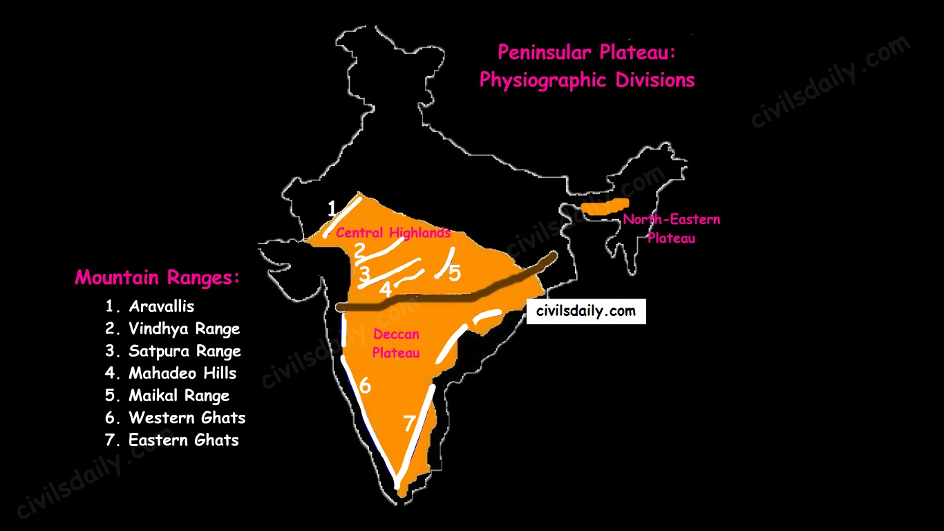
Physiographic Divisions:
On the basis of prominent relief features, the peninsular plateau can be divided into three broad groups:
- The Central Highlands
- The Deccan Plateau
- The Northeastern Plateau.
Let’s take up these divisions one by one:
1. The Central Highlands
- The northern segment of the peninsular plateau is known as the Central Highlands.
- Location:
- North of Narmada river.
- They are bounded to the west by the Aravallis.
- Satpura ranges (formed by a series of scarped plateaus) lie in the South.
- General Elevation: 700-1,000 m above the mean sea level and it slopes towards the north and northeastern directions.
- These highlands consist of the:
- Marwar upland – to the east of Aravallis in Rajasthan
- A rolling plain carved by Banas river. [Rolling Plain: ‘Rolling plains’ are not completely flat; there are slight rises and fall in the land form. Ex: Prairies of USA]
- Average elevation is 250-500 m above sea level.
- Madhya Bharat Pathar – to the east of Marwar upland.
- Malwa plateau – It lies in Madhya Pradesh between Aravali and Vindhyas. It is composed of extensive lava flow and is covered with black soils.
- Bundelkhand plateau – It lies along the borders of UP and MP. Because of intensive erosion, semi-arid climate and undulating area, it is unfit for cultivation.
- Baghelkhand plateau – It lies to the east of the Maikal range.
- Chhotanagpur plateau – the north–east part of Peninsular plateau.
- It Includes Jharkhand, parts of Chhattisgarh and West Bengal.
- This plateau consists of series of step like sub-plateaus (locally called patlands – high-level plateau). It is thus famous as the Patland plateau and known as Ruhr of India.
- Rajmahal Hills are the northeastern projection of Chhota Nagpur Plateau.
- It is a mineral rich plateau.
- Marwar upland – to the east of Aravallis in Rajasthan
- The extension of the Peninsular plateau can be seen as far as Jaisalmer in the West, where it has been covered by the longitudinal sand ridges and crescent-shaped sand dunes called barchans.
- This region has undergone metamorphic processes in its geological history, which can be corroborated by the presence of metamorphic rocks such as marble, slate, gneiss, etc.
- Most of the tributaries of the river Yamuna have their origin in the Vindhyan and Kaimur ranges. Banas is the only significant tributary of the river Chambal that originates from the Aravalli in the west.
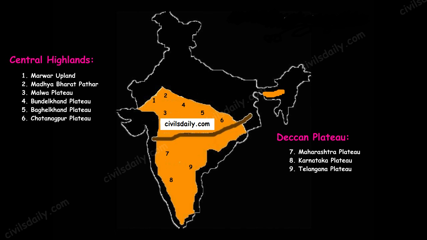
2. The Deccan Plateau
- The Deccan Plateau lies to the south of the Narmada River and is shaped as an inverted triangle.
- It is bordered by:
- The Western Ghats in the west,
- The Eastern Ghats in the east,
- The Satpura, Maikal range and Mahadeo hills in the north.
- It is volcanic in origin, made up of horizontal layers of solidified lava forming trap structure with step-like appearance. The sedimentary layers are also found in between the layers of solidified lava, making it inter–trapping in structure.
- Most of the rivers flow from west to east.
- The plateau is suitable for the cultivation of cotton; home to rich mineral resources and a source to generate hydroelectric power.
- The Deccan plateau can be subdivided as follows:
- The Maharashtra Plateau – it has typical deccan trap topography underlain by basaltic rock, the regur.
- The Karnataka Plateau (also known as Mysore plateau) – divided into western hilly country region of ‘Malnad’ and plain ‘Maidan’
- Telangana Plateau
3. The Northeastern Plateau:
- The Meghalaya (or Shillong) plateau is separated from peninsular rock base by the Garo-Rajmahal gap.
- Shillong (1,961 m) is the highest point of the plateau.
- The region has the Garo, Khasi, Jaintia and Mikir (Rengma) hills.
- An extension of the Meghalaya plateau is also seen in the Karbi Anglong hills of Assam.
- The Meghalaya plateau is also rich in mineral resources like coal, iron ore, sillimanite, limestone and uranium.
- This area receives maximum rainfall from the south-west monsoon. As a result, the Meghalaya plateau has a highly eroded surface. Cherrapunji displays a bare rocky surface devoid of any permanent vegetation cover.
Hill ranges of the peninsula:
Most of the hills in the peninsular region are of the relict type (residual hills). They are the remnants of the hills and horsts formed many million years ago (horst: uplifted block; graben: subsided block).
The plateaus of the Peninsular region are separated from one another by these hill ranges and various river valleys.
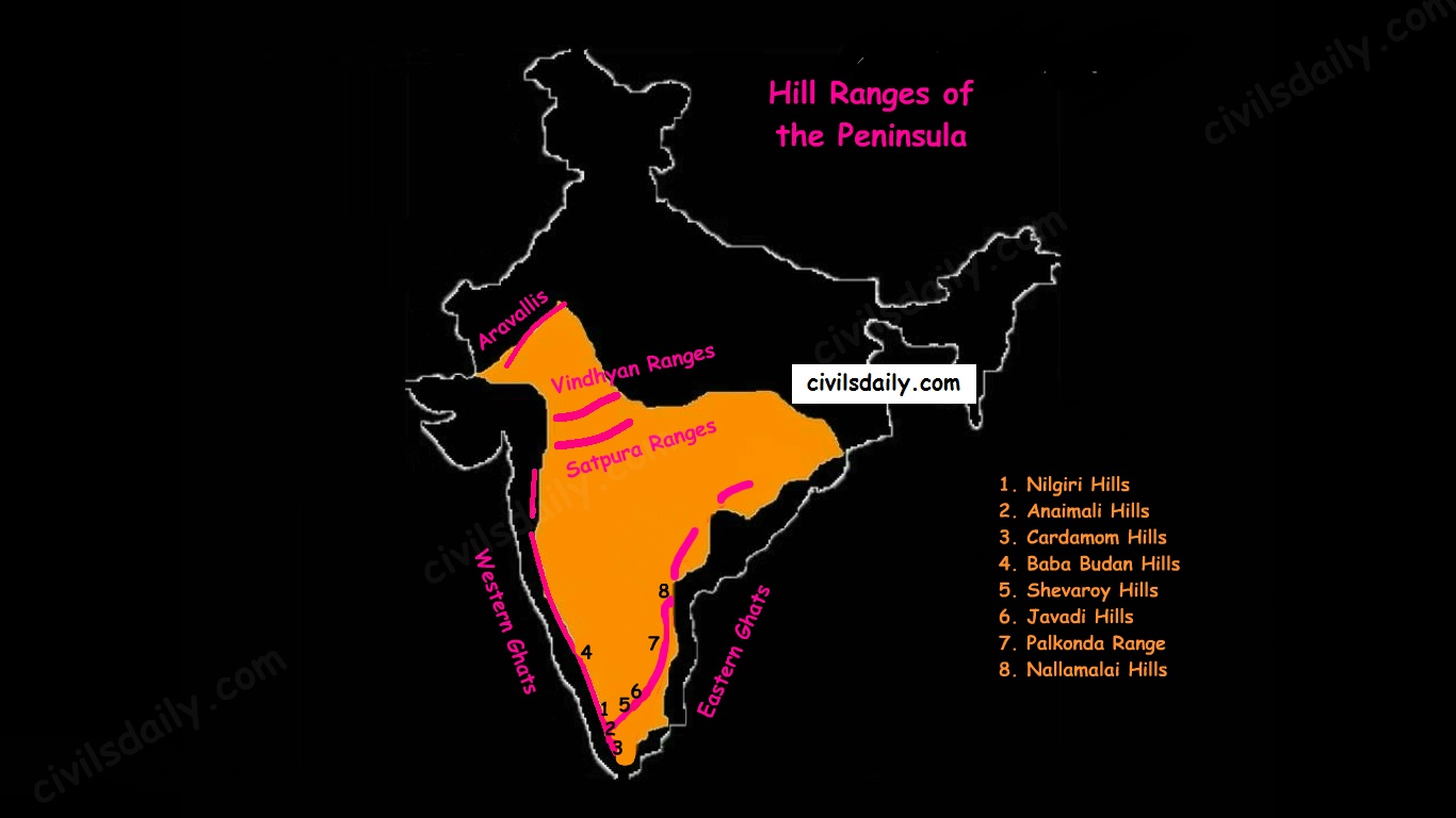
1. The Aravalli Mountain Range:
- It is a relic of one of the oldest fold mountains of the world.
- Its general elevation is only 400-600 m, with few hills well above 1,000 m.
- At present, it is seen as a discontinuous ridge from Delhi to Ajmer and rising up to 1722m (Gurushikhar peak in Mount Abu) and thence southward.
- It is known as ‘Jarga’ near Udaipur and ‘Delhi Ridge’ near Delhi.
- Dilwara Jain Temple, the famous Jain temple is situated on Mt. Abu.
2. Vindhyan Ranges:
- They rise as an escarpment running parallel to the Narmada-Son valley.
- General elevation: 300 to 650 m.
- Most of them are made up of sedimentary rocks of ancient ages.
- They act as a watershed between Gangetic and peninsular river systems.
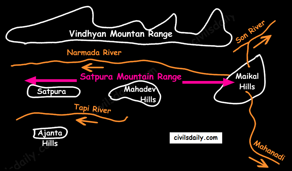
3. Satpura ranges:
- Satpura range is a series of seven mountains (‘Sat’ = seven and ‘pura’ = mountains).
- The seven mountain ranges or folds of Satpura’s are:
- Maikal Hills
- Mahadeo Hills near Pachmarhi
- Kalibhit
- Asirgarh
- Bijagarh
- Barwani
- Arwani which extends to Rajpipla Hills in Eastern Gujarat.
- Satpura ranges run parallel between Narmada and Tapi, parallel to Maharashtra-MP border.
- Dhupgarh (1,350 m) near Pachmarhi on Mahadev Hills is the highest peak of the Satpura Range.
- Amarkantak (1,127 m) is another important peak. Amarkantak is the highest peak of the Maikal Hills from where two prominent rivers – the Narmada and the Son originate.
- Note that three rivers originate from the three sides of Maikal hills (as shown in the following map) but, from Amarkantak, only two rivers (the Narmada and the Son) originate (and not Mahanadi).
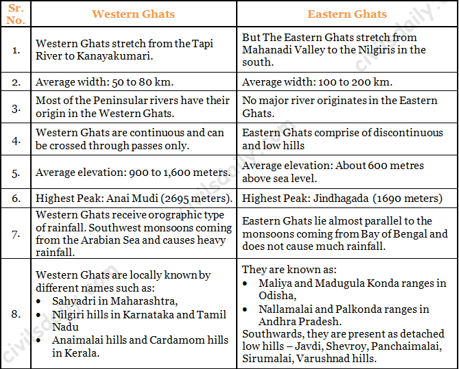
4. Western and Eastern Ghats:
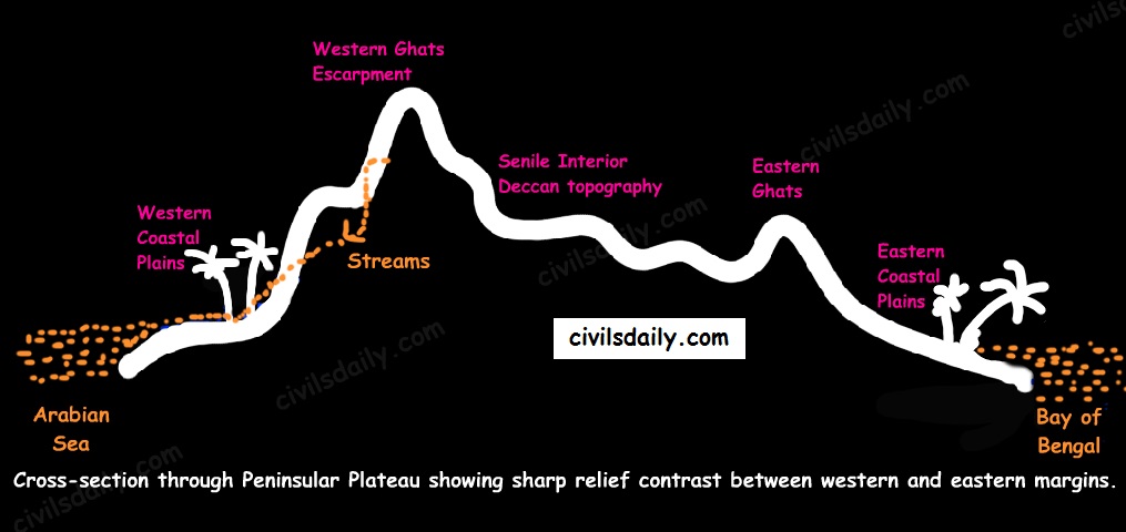
- The Western Ghats:
- These are a faulted part of the Deccan plateau running parallel from the Tapi valley to a little north of Kanyakumari (1600km). Their western slope is like an escarpment while eastern slope merges gently with the plateau.
- Their average elevation is about 1,500 m with the height increasing from north to south.
- The Eastern Ghats are in the form of residual mountains which are not regular but broken at intervals.
- The Eastern and the Western Ghats meet each other at the Nilgiri hills.
- A brief comparison between them:
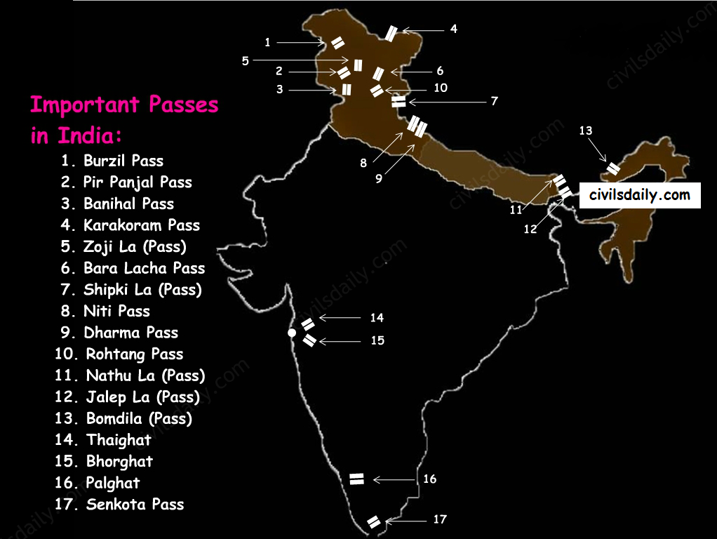
Note: The Western Ghats are continuous and can be crossed through passes only. There are four main passes which have developed in the Western Ghats. These are:
- Thal Ghat – It links Nasik to Mumbai.
- Bhor Ghat – It links Mumbai to Pune.
- Pal Ghat – This pass is located between the Nilgiris and the Annamalai mountains. It is in Kerala and connects Kochi and Chennai.
- Senkota Pass – This pass located between the Nagercoil and the Cardamom hills links Thiruvananthapuram and Madurai.
For the geographical location of these passes, see the following map:
Significance of the Peninsular Region:
- Rich in mineral resources: The peninsular region of India is rich in both metallic and non-metallic minerals. About 98% of the Gondwana coal deposits of India are found in the peninsular region.
- Agriculture: Black soil found in a substantial part of the peninsula is conducive for the cultivation of cotton, maize , citrus fruits etc. Some areas are also suitable for the cultivation of tea, coffee, groundnut etc.
- Forest Products: Apart from teal, sal wood and other forest products, the forests of Western and Eastern Ghats are rich in medicinal plants and are home to many wild animals.
- Hydel Power: many rivers, which have waterfalls. They help in the generation of hydroelectric power.
- Tourism: There are numerous hill stations and hill resorts like Ooty, Mahabaleshwar, Khandala, etc.
Now that we are done with this part, let’s try to attempt some questions from the past UPSC examinations:
Prelims:
1995
Question: Which one of the following mountain ranges is spread over only one state in India?
A) Aravalli
B) Satpura
C) Ajanta
D) Sahyadri
Ans. C
1997
Question: Consider the map given below:
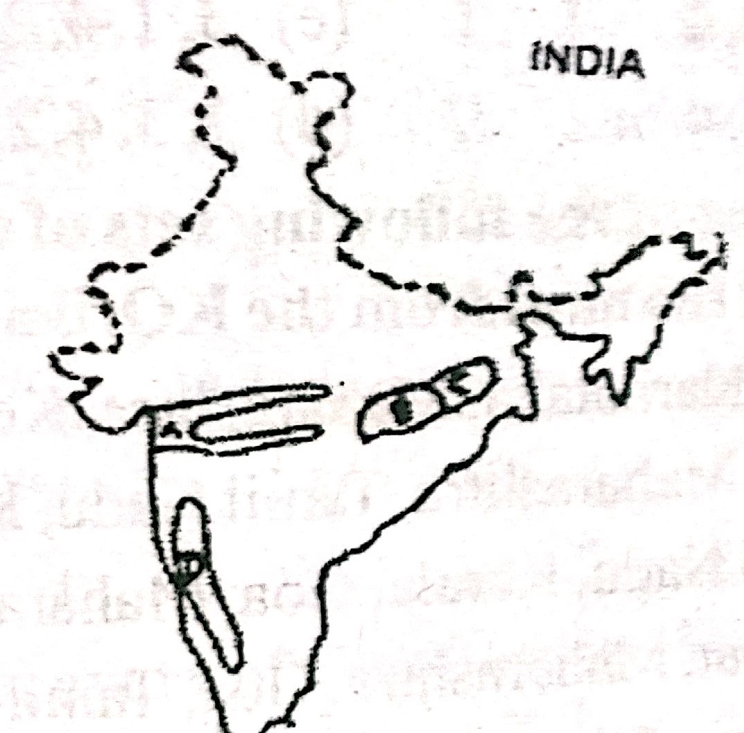
The places marked A,B, C, and D in the map are respectively
A) Rift valley region, Chattisgarh plain, Rain shadow region, and Chotanagpur Plateau
B) Chattisgarh plain , Chotanagpur Plateau, Rift valley region, Rain shadow region
C) Rift valley region, Chattisgarh plain, Chotanagpur Plateau and Rain shadow region
D) Chattisgarh plain , Rain shadow region, Chotanagpur Plateau, Rift valley region,
Ans. C
2005
Question: Which one of the following statements is not correct?
A) The Western Ghats are relatively higher in their northern regions.
B) The Anaimudi is the highest peak in the Western Ghats
C) Tapi river lies to the south of Satpura
D) The Narmada and the Tapi river valleys are said to be old rift valleys.
Ans. A
Question: Which one of the following is the correct sequence of the given hills starting from the north and going towards the south?
A) Nallamalai Hills – Nilgiri Hills – Javadi Hills – Anaimalai Hills
B) Anaimalai Hills – Javadi Hills – Nilgiri Hills – Nallamalai Hills
C) Nallamalai Hills – Javadi Hills – Nilgiri Hills – Anaimalai Hills
D) Anaimalai Hills – Nilgiri Hills – Javadi Hills – Nallamalai Hills
Ans. C
2007
Question: In which state is the Guru Shikhar peak located?
- Rajasthan
- Gujarat
- Madhya Pradesh
- Maharashtra
Ans. A


thank you sir
Amazing content
systematic and informative content. thank you