Its important to analyze the role of water in the atmosphere. Water is present in 3 forms – namely gaseous, liquid and solid.
Lets go through some simple but important definitions
- Humidity : A generic term to refer to the amount of water vapour present in the atmosphere.
- Absolute Humidity : Its the actual weight of the water vapour(grams) present per unit volume(cubic meter m^3) of the atmosphere. This gives us an estimate of the actual amount of water present in a given atmosphere.
- Relative Humidity : The % of water vapour present in the atmosphere compared to its full capacity at a given temperature is called Relative Humidity.
- Condensation : Transformation of water vapour into water is called condensation. It releases heat.
- Sublimation : When the water vapour directly condenses into solid form, it is called sublimation.
Now, you would’ve guessed, water vapour in the atmosphere is a function of temperature. As you increase the temperature of the air, you increase its water holding capacity. This relationship is best described by the graph below. You can make out, its not linear.

We come to the most important concept of this topic – SATURATION. We will be required to understand what it means, what it can do and most importantly what are the different ways it can happen.
Water in the atmosphere is mostly lying idle. However all the magic happens when saturation point is reached. By Saturation we mean air, at that temperature is incapable of holding any additional moisture. The temperature at which saturation occurs in a given sample of air is known as dew point.
How can we bring about saturation? Well, the most logical thing to say here would be by increasing the amount of water vapour. Thats correct. Another important method would be to bring down the maximum holding capacity of the air by bringing down the temperature of the atmosphere to dew point. The next section will explain why the second method is the most preferred one.
CONDENSATION
After Saturation, Condensation takes place. And when it happens, one of the following will be formed – dew, frost, fog and clouds. Lets see how –
- Add Moisture – Pretty obvious. You add more moisture, the relative humidity increases till the saturation point reaches.
- Cooling by removing heat – If I remove heat from the atmosphere, I’ll most certainly bring down the temperature to dew point and saturate the air. When condensation takes place within itself on dust particles, its called fog.
- Radiation Fog : Occurs on clear nights on land. As we’ve studied earlier, during the night we have relatively cool earth because its not being heated by the sun and much of its infrared radiation can escape to space. Thus fog if formed near the earth’s surface.

- Advection Fog : Occurs over cold ocean currents. When we have an already cold surface and moisture laden winds pass through it, they condense. The only difference between Advection and Radiation is the method of cooling. In the first case, we had the surface that was getting cooled while in the second we already had a cool surface to begin with. All cold currents of the world with warm air blowing over them will experience this. Also remember, sea-smoke is almost the opposite of this – when we have cold air and warm water.

- Dew : Mostly observed in early morning. When the saturated air comes in contact with cold surfaces like that of leaves, trees, grass, etc.
- Frost : Same as above, but in this case the Due Point is below 0^C. This leads to the formation of ice-crystals instead of droplets.
- Radiation Fog : Occurs on clear nights on land. As we’ve studied earlier, during the night we have relatively cool earth because its not being heated by the sun and much of its infrared radiation can escape to space. Thus fog if formed near the earth’s surface.
- Cooling by adiabatic expansion – If we make the air just rise, it will expand, lose heat and saturate.
- Leads to the formation of clouds
- Vortices
- Supersonic flight
Lets come to one of the most interesting topics – Clouds. Repeating what we’ve already established – adiabatic cooling is responsible for the formation of clouds. Clouds will always have water. If they don’t then its just air, its not a cloud. Its interesting to note that though all clouds have water, they might not rain(precipitate would be a more correct term to use). However for every rainfall there has to be a corresponding cloud.
CLASSIFICATION OF CLOUDS
The general classification of clouds was proposed by Luke Howard in 1803. It was descriptive based on shape and height.
A. On the basis of Shape
Cumulus – A heap or a pile of cotton mass. They look like cotton wool. They are formed at a height of 4K-7K m. They exist is patches and have a flat base.
There’s an timelapse video where you can observe the process happening. The air doesn’t rise much higher than the ground, forms clouds and descends. And these clouds appear and disappear.
Stratus – As the name implies they are layered clouds covering large portions of the sky. Formed due to loss of heat of mixing of air masses. They are spread out and mostly found in the lower heights (as shown in the video).
Cirrus – Cirrus clouds are formed at high altitudes (8K-12K m). They are thin and detached clouds having a feathery appearance.
B. On the basis of Height
As low clouds, middle clouds and high clouds.
In this classification, Luke Howard very intelligently re-uses the terms defined in A. How ?? He notices that all low clouds are generally Stratus and all high clouds are generally Cirrus. Meaning he didn’t have to look for separate words for low and high clouds. Eg. A high Cumulus cloud becomes – cirrocumulus. Similarly a low cumulus cloud becomes stratocumulus.
He, however had to coin a term for middle – ‘Alto’. Eg. Altostratus, Altocumulus implies clouds of middle height.
Nimbus : It is used as an adjective to the above clouds to indicate that these clouds are black or grey suggesting they are rain-bearing. Eg. cumulonimbus clouds are those huge clouds that lead to thunderstorm and lightening.
PRECIPITATION
As we had earlier pointed out, clouds alone cannot give precipitation. While the theory behind cloud formation is understood in science, what happens after cloud formation to result in precipitation is not so clearly understood.
We know one thing for sure, for precipitation to take place, the cloud droplets (10 microns) need to grow in size. A raindrop has 100 times the radius of a cloud droplet. So the cloud droplets have to grow that large in order to overpower the force of gravity and upward turbulence and finally come down.
There are 2 theories proposed in this regard :
I. Collision Coalescence : It assumes that you have differently sized droplets where the large ones collide with the small ones and form bigger particles. Why? the larger ones will be moving at a different pace, hence they are bound to collide with the smaller ones coming in their way. It’s not a very efficient process most of the time, because more often that not, you will have similar cloud droplets, not varying too much in size. There’s not enough of a range of large to small particles to get this going. But on occasion, especially over tropical oceans, this mechanism is thought to dominate.
II. Ice Crystal Formation Theory : Before we discuss this in detail, lets see the different forms in which water exists.
T>0 : Water
-40<T<0 : Supercooled water (This is water thats not frozen but will freeze as soon as it comes in contact with a nuclei)
T<-40 : Ice
This theory assumes that you have supercooled water droplets in the cloud. This could happen because lets say the whole of the cloud or a part of it is below the freezing point. Now some of this supercooled water freezes and becomes ice crystals. Now these ice crystals have the tendency to attract water droplets.
Supercooled water condenses on these ice crystals. This forms the snowflakes. Once this starts falling, it may collide with other water droplets or ice crystals forming Hail. Similarly as they fall and experience a warmer atmosphere, they may melt and convert to rain.

FORMS OF PRECIPITATION
As we noted above, after condensation, the release of moisture is known as precipitation. It can occur in the following forms.
- Rain : Precipitation in form of water is called rain.
- Drizzle : Is spray like rainfall which is very slow with water droplets having .mm diameter. They mostly happen via stratus clouds.
- Snow : As discussed above, when ice crystals come down.
- Sleet : When the falling water experiences a cool atmosphere just before touching the earth and freezes forming a sheet.

- Hail : Is the most complex of all precipitation. It mostly originates from the cumulonimbus clouds as a result of active turbulence and vertical air currents.
RAINFALL
We will study in detail, the most common form of precipitation – Rainfall.
Rainfall can be classified on the basis of its origin.
- Convectional : When air is being heated, it rises up and cools adiabatically. When such cooling appears, it saturates. This leads to cloud formation which may in turn lead to shedding of excess moisture in form of Rain. Such rain doesn’t last long. As you saw, the precondition for such rainfall was the air being heated. Hence this type of rainfall is mainly a feature of equatorial regions particularly in the Northern Hemisphere.
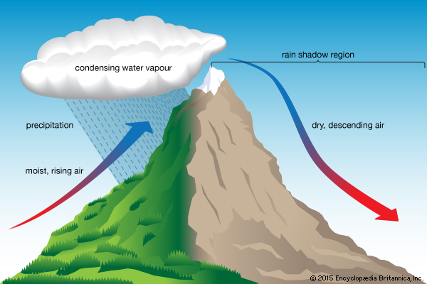
- Orographic : It is due to a topographic barrier. When the moist air hits the windward side of a mountain, it is forced to rise which cause it to adiabatically cool and saturate. Hence the windward side receives rain. The cool air descends towards the leeward side making that area dry.
- Frontal : Frontal rainfall is a feature of middle latitudes. It will be more clear when we’ve gone through what fronts are in the topic Atmospheric circulations. Just for some conceptual clarity, we say fronts are boundary of two different air masses say warm air mass and cold air mass. When these two airs masses meet, rain might occur. This type of rainfall is called frontal rains.
