Note4Students
From UPSC perspective, the following things are important :
Prelims level: Darvaza Gas Crater, TAPI gas pipeline
Mains level: Not Much

Turkmenistan President has ordered experts to find a way to extinguish a fire in a huge natural gas crater, the Darvaza gas crater also known as the ‘Gateway to Hell’.
Darvaza Gas Crater
- Located in the Karakum desert, 260 kilometres away from Turkmenistan’s capital, Ashgabat, the crater has been burning for the last 50 years.
- The crater is 69 metres wide and 30 metres deep.
- While the details of the origin of the crater are contested but it has been said that the crater was created in 1971 during a Soviet drilling operation.
- In 1971, Soviet geologists were drilling for oil in the Karakum desert when they hit a pocket of natural gas by mistake, which caused the earth to collapse and ended up forming three huge sinkholes.
Why is it flamed?
- This pocket of natural gas contained methane, hence to stop that methane from leaking into the atmosphere, the scientists lit it with fire, assuming the gas present in the pit would burn out within a few weeks.
- The scientists seemed to have misjudged the amount of gas present in the pit, because the crater has been on fire for five decades now.
A popular tourist attraction
- The crater has become a significant tourist attraction in Turkmenistan.
- In 2018, the country’s president officially renamed it as the “Shining of Karakum”.
Why did Turkmenistan order to extinguish it?
- Calling it a human-made crater, it has negative effects on both environment and the health of the people living nearby.
- It also ends up losing valuable natural resources for which could fetch significant profits.
How harmful are methane leaks?
- Methane is the primary contributor to the formation of ground-level ozone, a hazardous air pollutant and greenhouse gas, exposure to which causes 1 million premature deaths every year.
- Methane is also a powerful greenhouse gas. Over a 20-year period, it is 80 times more potent at warming than carbon dioxide.
Back2Basics: TAPI Gas Pipeline
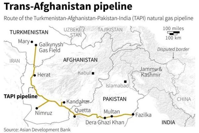
- The Turkmenistan–Afghanistan–Pakistan–India (TAPI) Pipeline is a natural gas pipeline being developed with the participation of the Asian Development Bank.
- It will be a 1,814km trans-country natural gas pipeline running across four countries.
- It will transport natural gas from the Galkynysh Gas Field in Turkmenistan through Afghanistan into Pakistan and then to India.
- The plan for the TAPI project was originally conceived in the 1990s to generate revenue from Turkmenistan’s gas reserves by exporting natural gas via Afghanistan to Pakistan and India.
- Construction on the project started in Turkmenistan on 13 December 2015, work on the Afghan section began in February 2018, and work on the Pakistani section was planned to commence in December 2018.
- Presently, the construction work has been stalled due to terror activities of Taliban in Afghanistan since few years.
UPSC 2022 countdown has begun! Get your personal guidance plan now! (Click here)
Get an IAS/IPS ranker as your 1: 1 personal mentor for UPSC 2024
Attend Now
Note4Students
From UPSC perspective, the following things are important :
Prelims level: Orang NP
Mains level: NA
The Assam government has recently issued a preliminary notification for adding 200.32 sq. km to the 78.82 sq. km Orang National Park, the State’s oldest reserve, about 110 km northeast of Guwahati.
The government had in September 21 dropped the ‘Rajiv Gandhi’ prefix to Orang given by the government in 1992.
Orang National Park
- Orang NP is located on the northern bank of the Brahmaputra River in the Darrang and Sonitpur districts of Assam.
- It was established as a sanctuary in 1985 and declared a national park in 1999.
- It has a rich flora and fauna, including great Indian rhinoceros, pygmy hog, Asian elephant, wild water buffalo and Bengal tiger.
- Orang, on the northern bank of the river, is strategic to the Kaziranga Orang Riverine Landscape.
- Tigers and rhinos are known to use the islands in this riverine landscape, about 180 km long, to hop between Orang and Kaziranga.
Why in news?
- The Assam government is pursuing a policy for the reintroduction of the gharial that became locally extinct more than six decades ago.
- With better protection, the stretch of the Kaziranga-Orang landscape is ideal for sustaining the gharials.
Back2Basics: National Park
- Even before the Indian independence, sanctuaries had been created in the form of shooting blocks, game reserves or hunting reserves by the provisional governments or by the native rulers in their respective areas.
- In 1936, the first National Park in India was created and named as the Hailey National Park, now called the Corbett National Park, in Uttaranchal.
- The Wildlife Protection Act 1972 provides for the declaration of five types of protected areas viz. National Parks, Wildlife Sanctuaries, Community Reserves, Conservation Reserves and Tiger Reserves.
- A National Park is defined by state government via notification under the WPA.
- The state government can fix and alter boundaries of the National Parks with prior consultation and approval with National Board of Wildlife.
- There is no need to pass an act for alternation of boundaries of National Parks.
- No human activities are permitted in a National Park.
UPSC 2022 countdown has begun! Get your personal guidance plan now! (Click here)
Get an IAS/IPS ranker as your 1: 1 personal mentor for UPSC 2024
Attend Now
Note4Students
From UPSC perspective, the following things are important :
Prelims level: Pangong Tso
Mains level: LAC ambiguities

China is building a bridge across the Pangong Tso area connecting the North and South Banks which will significantly reduce the time for moving troops and equipment between the two sides.
About Pangong Tso
- Pangong Tso or Pangong Lake is an endorheic lake in the Himalayas situated at a height of about 4,350 m.
- It is 134 km long and extends from India to the Tibetan Autonomous Region, China.
- Approximately 60% of the length of the lake lies within the Tibetan Autonomous Region.
- The lake is 5 km wide at its broadest point. All together it covers 604 sq.km.
- During winter the lake freezes completely, despite being saline water.
- It is not a part of the Indus river basin area and is geographically a separate landlocked river basin.
- Earlier, Pangong Tso had an outlet to Shyok River, a tributary of Indus River, but it was closed off due to natural damming.
Tactical significance of the lake
- It lies in the path of the Chushul approach, one of the main approaches that China can use for an offensive into Indian Territory.
- During the 1962 war, this was where China launched its main offensive — the Indian Army fought heroically at Rezang La under Maj. Shaitan Singh.
- Not far away, to the north of the lake, is the Army’s Dhan Singh Thapa post, named after Major Dhan Singh Thapa who was awarded the country’s highest gallantry award, the Param Vir Chakra.
- Major Thapa and his platoon were manning the Sirijap-1 outpost which was essential for the defense of the Chushul airfield.
Connectivity in the region
- Over the years, the Chinese have built motorable roads along their banks of the Pangong Tso. This points to the importance accorded by the Chinese to the area.
- Even during peacetime, the difference in perception over where the LAC lies on the northern bank of the lake makes this contested terrain.
- In 1999, when the Army unit from the area was moved to Kargil for Operation Vijay, China took the opportunity to build 5 km of a road inside the Indian Territory along the lake’s bank.
- From one of these roads, Chinese positions physically overlook Indian positions on the northern tip of the Pangong Tso Lake.
What is the importance of the bridge over Pangong Tso?
- The bridge over Pangong Tso is located around 25 kms ahead of the LAC in Chinese territory and will significantly reduce the time for movement of Chinese army.
- The Indian Army gained tactical advantage over the PLA on the south bank in end August 2020 by occupying several peaks lying vacant since 1962 gaining a dominating view.
- This has prompted China to build deep alternate roads behind the friction points away from the line of sight.
How is India responding to developments on the ground?
- The bridge is well within Chinese territory.
- The implications of this new bridge will have to be factored in the Indian Army’s operational planning for the future.
- On its part, over the last few years India has been focusing on infrastructure development in forward areas and improving connectivity to the forward areas.
- Large-scale construction of roads, bridges and tunnels is underway all along the LAC.
UPSC 2022 countdown has begun! Get your personal guidance plan now! (Click here)
Get an IAS/IPS ranker as your 1: 1 personal mentor for UPSC 2024
Attend Now
Note4Students
From UPSC perspective, the following things are important :
Prelims level: Chisumle- Demchok Road
Mains level: Critical border infrastructures

Ladakh’s Chisumle-Demchok Road, when it crosses the Umling Pass, is now the world’s highest motorable road.
Chisumle- Demchok Road
- The project to build the road through the pass — a part of Border Roads Organization (BRO) Project Himank — had been completed in 2017, after which vehicles had started playing on the route.
- The road is in south Ladakh. It passes through Umling La Pass, which is at a height of over 19,000 feet.
- The height of the pass makes it the highest motorable road in the world, and was recently recognized as such by Guinness World Records.
- The 52-km road ‘black-top’ tarmac road from Chisumle to Demchok betters the previous record of a road in Bolivia, which connects the volcano Uturuncu at 18,953 feet.
- The road was built under extremely challenging conditions, as temperatures in the region can fall to below minus 40 degrees Celsius, and oxygen levels go down to 50 per cent below normal.
Top of the world
- At the pass, the road is higher than both the base camps for the climb to Mount Everest, the world’s highest mountain.
- The South Base Camp in Nepal is at a height of 17,598 ft, while North Base Camp in Tibet is at 16,900 ft.
- The Chisumle-Demchok road is also higher than the Siachen Glacier, which is situated at 17,700 feet.
- Khardung La in Leh, which at one time was among the highest roads in the world, is at an altitude of 17,582 feet.
Military significance of the road
- This road provides a direct route from Chisumle, which lies on the major road coming from Leh, Karu and Nyoma.
- All of these stations have important military stations which are close to the Line of Actual Control.
- Demchok has been an India-China flashpoint earlier, the site of a standoff between the two armies in 2016.
- In the current standoff in eastern Ladakh, which began in May 2020, Demchok has come up as a point of contention.
Other benefits offered
- The new axis will be helpful for the armed forces, making it easier to mobilize troops and equipment, including rations.
- The road will not only enable faster movement of armed forces to the region but will also boost tourism and improve the socio-economic condition of the local people in the region.
Certain limitations
- Since the road goes through such a high pass, road transport will be unfeasible during the winter, when the armed forces rely on air support.
UPSC 2022 countdown has begun! Get your personal guidance plan now! (Click here)
Get an IAS/IPS ranker as your 1: 1 personal mentor for UPSC 2024
Attend Now
Note4Students
From UPSC perspective, the following things are important :
Prelims level: Deucha-Pachami Mines
Mains level: Not Much
Thousands of Tribals fear displacement following the implementation of the project to mine coals and basalts from the Deucha-Pachami coal block in West Bengal’s Birbhoom district.
Deucha-Pachami Mines
- Deucha-Pachami-Dewanganj-Harinsinga coal block is the second-largest coal block in the world; it is the largest in India.
- It is located in Deucha and Panchamati area under Mohamad bazar community Development Block of Birbhum district, West Bengal.
- The block has a thick coal seam trapped between equally thick layers of rocks, mostly basalt. It has a great economic value.
- The existence of these thick basalt layers, however, makes mining of coal difficult; foreign investment and technology will be hence needed for mining.
UPSC 2022 countdown has begun! Get your personal guidance plan now! (Click here)
Get an IAS/IPS ranker as your 1: 1 personal mentor for UPSC 2024
Attend Now
Note4Students
From UPSC perspective, the following things are important :
Prelims level: Carmichael Mine
Mains level: NA

The Adani Group will begin exporting high quality, low sulphur coal from its Carmichael mine in Australia as early as this week, tapping a new multi-decade source to meet energy needs.
Carmichael Mine
- The Carmichael mine is located in the North Galilee Basin, more than 300 kilometers from the Queensland coastline and approximately 160 km north-west of Clermont in regional Queensland.
- The Carmichael project, proposed in 2010, had provoked a sustained campaign by climate activists in Australia and other places globally, forcing banks and insurers not to work with the Adani group.
- The conglomerate run by India’s second-richest man Gautam Adani has planned an initial production of 10 million tonnes a year from the mines in the Galilee Basin.
- The Coal mined here has low sulfur content and high calorific value.
UPSC 2022 countdown has begun! Get your personal guidance plan now! (Click here)
Get an IAS/IPS ranker as your 1: 1 personal mentor for UPSC 2024
Attend Now
Note4Students
From UPSC perspective, the following things are important :
Prelims level: Irrecoverable Carbon
Mains level: Global carbon sinks

Researchers have identified and mapped 139 gigatonnes (Gt) of “irrecoverable carbon” in some of the world’s major forests and peatlands — including the Amazon and the Congo — to avoid catastrophic climate change.
What is Irrecoverable Carbon?
- The concept of ‘irrecoverable carbon’ was introduced in 2020.
- All kinds of ecosystems — lush rainforest, muddy peatland, shady mangroves — contain eons of stored carbon, captured by photosynthesis.
- Per square kilometer, the forests are among the most effective carbon stores in the world; but they’re also some of the most difficult to restore.
- If destroyed, these ecosystems could take decades or centuries to regenerate.
- In other words, the 139 gigatons of carbon contained in these areas are effectively irrecoverable if released due to anthropogenic activities.
- Once released in air, it can be recovered but would take centuries to fully recover or naturally reintegrate.
What is the new research?
- In the new study, researchers have identified and mapped carbon reserves that are “manageable, are vulnerable to disturbance” and cannot be recovered by 2050.
- They held study of peatlands of the Congo Basin and Northern Europe; and in North America, the mangrove swamps of the Everglades and old-growth forests of the Pacific Northwest.
- 2050 has been set as the deadline for taking global carbon emissions to net zero in order for Earth to avoid warming at 1.5-2 degrees celsius above the pre-industrial levels.
- To mitigate such a warming scenario, it is imperative to conserve the ecosystems with 139 Gt carbon.
Key findings
- Amazon is the biggest carbon sink on earth, holding 31.5 Gt irrecoverable carbon.
- Brazil has the second-largest irrecoverable carbon reserves, after Russia that holds 23 per cent of the total irrecoverable carbon outlay in the world.
- The second-largest reserve of carbon, at 132 Gt, comprise the islands of Southeast Asia, with their equatorial rainforests.
- The Congo basin is the third-largest hotspot of irrecoverable carbon with over 8 Gt of carbon reserves, according to the study.
- Australia, which has become a hotspot for wildfires, is home to 2.5 per cent of the world’s carbon reserve along its coastal mangroves and forests in the southeast and southwest.
Why conserve these forests?
- These regions are already being ravaged by wildfires and exploited for resources by mining and oil industries.
- Since 2010, agriculture, logging and wildfire have caused emissions of at least 4 Gt of irrecoverable carbon.
UPSC 2022 countdown has begun! Get your personal guidance plan now! (Click here)
Get an IAS/IPS ranker as your 1: 1 personal mentor for UPSC 2024
Attend Now
Note4Students
From UPSC perspective, the following things are important :
Prelims level: Chalcolithic culture in India
Mains level: Not Much
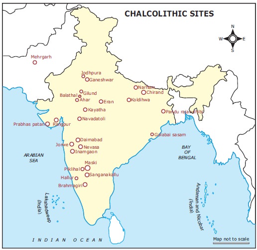
The Chalcolithic cultures of Central India are adequately investigated and studied informed the Ministry of Culture in particular reference to the sites of Eran and Tewar.
Major sites in Central India
[1] Eran (Dist. Sagar, MP )
- Eran (ancient Airikina) is situated on the left bank of the Bina (ancient Venva) river and surrounded by it on three sides.
- The recent excavation has unearthed a variety of antiquities including a copper coin, an iron arrowhead, terracotta bead, stone beads along with copper coins, stone celt, beads of steatite and jasper, etc.
- The occurrence of few specimens of plain, thin grey ware is noteworthy.
- The use of iron was evidenced by few metallic objects at the site.
[2] Tewar (Dist. Jabalpur, MP)
- Tewar (Tripuri) village is located 12 km west of Jabalpur district on Jabalpur – Bhopal highway.
- This excavation did not reach the natural soil and revealed four folds of cultural sequences i.e. Kushana, Shunga, Satvahana, and Kalachuri.
- Antiquarian remains in this excavation include viz remains of sculptures, hopscotch, terracotta balls, Iron nails, copper coins, terracotta beads, implements of Iron and terracotta figurine, ceramics red ware etc.
- It also revealed structural remains consist of brick wall and structure of sandstone columns.
Back2Basics: Chalcolithic Culture in India
- A completely different kind of culture known as Chalcolithic Culture was developed in central India and Deccan region by the end of the Neolithic period.
- It is characterized by the use of both stone and bronze implements.
Major Chalcolithic complexes in India
- Ahar culture c. 2,800-1,500 B.C.
- Kayatha culture c. 2,450-700 B.C.
- Malwa culture c. 1,900-1,400 B.C.
- Savalda culture c. 2,300-2,000 B.C.
- Jorwe culture c. 1,500 -900 B.C.
- Prabhas culture c. 2,000-1,400 B.C.
- Rangpur culture c. 1,700-1,400 B.C.
Important features
- The people of Chalcolithic culture had used unique painted earthenware usually black-on-red.
- The use of copper and bronze tools also evidenced on a limited scale.
- The economy was largely based on subsistence agriculture, stock-raising, hunting, and fishing.
- They, however, never reached the level of urbanization in spite they were using metal.
- They were contemporary of the Harappan culture, but some other were of later Harappan age.
Their locations
- The centers of Chalcolithic cultures flourished in semi-arid regions of Rajasthan, Madhya Pradesh, Gujarat, and Maharashtra.
- The settlements of Kayatha culture were mostly located on the Chambal River and its tributaries.
- The settlements of Malwa culture are mostly located on the Narmada and its tributaries.
- The three best known settlements of Malwa culture are at Navdatoli, Eran, and Nagada.
- Navdatoli was one of the largest Chalcolithic settlements in the country spread in almost 10 hectares.
- The settlements of Rangpur culture are located mostly on Ghelo and Kalubhar rivers in Gujarat.
- More than 200 settlements of Jorwe culture are known. Greater numbers of these settlements are found in Maharashtra.
- The best known settlements of Jorwe culture are Prakash, Daimabad, and Inamgaon. Daimabad was the largest one that measured almost 20 hectares.
Development of Agriculture
- They cultivated both Kharif and Rabi crops in rotation and also raised cattle with it.
- They cultivated wheat and barley in Malwa region. Rice was cultivated in Inamgaon and Ahar.
- They also cultivated jowar, bajra, kulth, ragi, green peas, lentil, and green and black grams.
- Largely, the Chalcolithic cultures flourished in the black cotton soil zone.
Trade and Commerce
- The Chalcolithic communities traded and exchanged materials with other contemporary communities.
- A large settlement serves as the major centers of trade and exchange.
- Some of them were Ahar, Gilund, Nagada, Navdatoli, Eran, Prabhas, Rangpur, Prakash, Daimabad, and Inamgaon.
- The Ahar people settled close to the copper source and were used to supply copper tools and objects to other contemporary communities in Malwa and Gujarat.
- Identical marks embedded on most of the copper axes found in Malwa, Jorwe, and Prabhas cultures that might indicate that it may be the trademarks of the smiths who made them.
- It is found that Conch shell for bangles was traded from the Saurashtra coast to various other parts of the Chalcolithic regions.
- Gold and ivory come to Jorwe people from Tekkalkotta in Karnataka and semiprecious stones may have been traded to various parts from Rajpipla in Gujarat.
- Wheeled bullock carts were used for long distance trade, besides the river transport. The drawings of wheeled bullock carts have been found on pots.
Try this PYQ from CSP 2019. It is dicey, but you cannot escape such questions.
Q. Which one of the following is not a Harappan site?
(a) Chanhudaro
(b) Kot Diji
(c) Sohgaura
(d) Desalpur
Post your answers here.
UPSC 2022 countdown has begun! Get your personal guidance plan now! (Click here)
Get an IAS/IPS ranker as your 1: 1 personal mentor for UPSC 2024
Attend Now
Note4Students
From UPSC perspective, the following things are important :
Prelims level: Buxa Tiger Reserve
Mains level: Success of Tiger Conservation

In a major success for tiger conservation, a photograph of a tiger was captured in a camera trap in West Bengal’s Buxa Tiger Reserve since 1998.
Locate all major tiger reserves in India.
Buxa Tiger Reserve
- Buxa Tiger Reserve is a tiger reserve in northern West Bengal, India, covering an area of 760 km2 (290 sq mi).
- In altitude, it ranges from 60 m in the Gangetic Plains to 1,750 m bordering the Himalayas in the north.
- Its northern boundary runs along the international border with Bhutan.
- The Sinchula hill range lies all along the northern side of BTR and the eastern boundary touches that of the Assam state.
Key features of BTR
- It is the easternmost extension of extreme bio-diverse North-East India and represents highly endemic Indo-Malayan region.
- The fragile “Terai Eco-System” constitutes a part of this reserve.
- The Phibsoo Wildlife Sanctuary of Bhutan is contiguous to the north of BTR.
- It serves as an international corridor for Asian elephant migration between India and Bhutan.
UPSC 2022 countdown has begun! Get your personal guidance plan now! (Click here)
Get an IAS/IPS ranker as your 1: 1 personal mentor for UPSC 2024
Attend Now
Note4Students
From UPSC perspective, the following things are important :
Prelims level: Sahel Region
Mains level: Great Green Wall Project

Africa’s Great Green Wall (GGW) program to combat desertification in the Sahel region is an important contribution towards combating climate change, Food and Agriculture Organization (FAO) said in a study.
Note the countries swept by the GGW project on the African map.
About GGW Program

- The Great Green Wall project is conceived by 11 countries located along the southern border of the Sahara and their international partners, is aimed at limiting the desertification of the Sahel zone.
- Led by the African Union, the initiative aims to transform the lives of millions of people by creating a mosaic of green and productive landscapes across North Africa.
- The initial idea of the GGW was to develop a line of trees from east to the west bordering the Saharan Desert.
- Its vision has evolved into that of a mosaic of interventions addressing the challenges facing the people in the Sahel and the Sahara.
Why was such project incepted?
- The project is a response to the combined effect of natural resources degradation and drought in rural areas.
- It aimed to restore 100 million hectares of degraded land by 2030; only four million hectares had been restored between 2007 and 2019.
- It is a partnership that supports communities working towards sustainable management and use of forests, rangelands and other natural resources.
- It seeks to help communities mitigate and adapt to climate change, as well as improve food security.
UPSC 2022 countdown has begun! Get your personal guidance plan now! (Click here)
Get an IAS/IPS ranker as your 1: 1 personal mentor for UPSC 2024
Attend Now
Note4Students
From UPSC perspective, the following things are important :
Prelims level: Nuclear Projects in India
Mains level: Nuclear Energy

If built on time, Jaitapur Project in Maharashtra would be the largest nuclear power generating station in the world by net generation capacity, at 9,900 MW.
Jaitapur Nuclear Power Project
- Jaitapur Project is a proposed nuclear power plant in India.
- The power project is proposed by Nuclear Power Corporation of India (NPCIL) and would be built at Madban village of Ratnagiri district in Maharashtra.
- It is being built with technical cooperation from France.
Project description
- It is proposed to construct 6 European Pressurized Reactors designed and developed by Framatome (former Areva) of France, each of 1650 MW, thus totaling 9900 MW.
- These are the third generation pressurized water reactors (PWR).
- The cost of building the plant is about ₹20 crore (US$2.7 million) per MW electric power compared with ₹5 crore (US$660,000) per MW electric power for a coal power station.
- A consortium of French financial institutions will finance this project as a loan. Both French and Indian government will give sovereign guarantee for this loan.
Issues with the project
(I) Liability for nuclear damage
- The lack of clarity on the Civil Liability for Nuclear Damage Bill 2010 passed in Indian Parliament in August 2010 is a hurdle in finalizing deal.
- This Civil Liability for Nuclear Damage Bill 2010 has a clause that deals with the legal binding of the culpable groups in case of a nuclear accident.
- It allows only the operator (NPCIL) to sue the manufacturers and suppliers. Victims will not be able to sue anyone.
(II) Clearance issue
- Environmental effects of nuclear power and geological issues have been raised by anti-nuclear activists of India against this power project.
- Even though the Maharashtra state govt completed land acquisition in 2010, only few people had accepted compensation cheques.
(III) Seismicity of the area
- Since Jaitapur is a seismically sensitive area, the danger of an earthquake has been foremost on the minds of people.
- According to the Earthquake hazard zoning of India, Jaitapur comes under Zone III. This zone is called the moderate Risk Zone and covers areas liable to MSK VIII.
- The presence of two major creeks on the proposed site has been ignored while clearing the site.
(IV) Nuclear waste disposal
- It is not clear where the nuclear waste from the site will be shipped for recycling or removed for disposal.
- The plant is estimated to generate 300 tonnes of used nuclear fuel each year.
UPSC 2022 countdown has begun! Get your personal guidance plan now! (Click here)
Get an IAS/IPS ranker as your 1: 1 personal mentor for UPSC 2024
Attend Now
Note4Students
From UPSC perspective, the following things are important :
Prelims level: Solomon Islands
Mains level: NA

Australia has announced sending police, troops and diplomats to the Solomon Islands to help after anti-Government demonstrators.
Solomon Islands
- Solomon Islands is a sovereign country consisting of six major islands and over 900 smaller islands in Oceania, to the east of Papua New Guinea and northwest of Vanuatu.
- Its capital, Honiara, is located on the largest island, Guadalcanal.
- The country takes its name from the Solomon Islands archipelago, which is a collection of Melanesian islands that also includes the North Solomon Islands (a part of Papua New Guinea).
- It excludes outlying islands, such as the Santa Cruz Islands and Rennell and Bellona.
UPSC 2022 countdown has begun! Get your personal guidance plan now! (Click here)
Get an IAS/IPS ranker as your 1: 1 personal mentor for UPSC 2024
Attend Now
Note4Students
From UPSC perspective, the following things are important :
Prelims level: Majuli Island
Mains level: Not Much

Soil erosion, coupled with changing climatic conditions, has been writing a cruel destiny for the inhabitants of Majuli in Assam, the largest river island in the world.
About Majuli Island
- Majuli is a riverine island in the Brahmaputra River, Assam and in 2016 it became the first island to be made a district in India.
- Majuli has shrunk as the river surrounding it has grown.
- It had an area of 880 square kilometers (340 sq mi) at the beginning of the 20th century but having lost significantly to erosion it covers 553 square kilometers as at 2014.
- It is the abode of the Assamese neo-Vaishnavite culture.
Its formation
- The island is formed by the Brahmaputra River in the south and the Kherkutia Xuti, an anabranch of the Brahmaputra, joined by the Subansiri River in the north.
- It was formed due to course changes by the river Brahmaputra and its tributaries, mainly the Lohit.
UPSC 2022 countdown has begun! Get your personal guidance plan now! (Click here)
Get an IAS/IPS ranker as your 1: 1 personal mentor for UPSC 2024
Attend Now
Note4Students
From UPSC perspective, the following things are important :
Prelims level: Mudumalai TR
Mains level: Not Much
P
PC: MapsOfIndia
A tiger believed to have been responsible for the death of two herders in the Mudumalai Tiger Reserve was finally captured.
Read all the tiger reserves in India through this map. Put more focus on South Indian states and the NE region.
Mudumalai Tiger Reserve
- Mudumalai National Park is a national park in the Nilgiri Mountains in Tamil Nadu.
- It is located in the Nilgiri District and shares boundaries with the states of Karnataka and Kerala.
- It is part of the Nilgiri Biosphere Reserve and was declared a tiger reserve in 2007.
- It harbours several endangered and vulnerable species including Bengal tiger, Indian leopard, Indian elephant and gaur.
Try this PYQ:
Q. Recently there was a proposal to translocate some of the lions from their natural habitat in Gujarat to which one of the following sites?
(a) Corbett National Park
(b) Kuno Palpur Wildlife Sanctuary
(c) Mudumalai Wildlife Sanctuary
(d) Sariska National Park
Post your answers here.
UPSC 2022 countdown has begun! Get your personal guidance plan now! (Click here)
Get an IAS/IPS ranker as your 1: 1 personal mentor for UPSC 2024
Attend Now
Note4Students
From UPSC perspective, the following things are important :
Prelims level: Jim Corbett NP
Mains level: Tiger Conservation

The Union Minister of State for Environment, Forest and Climate Change has recently proposed to change the name of Corbett National Park to Ramganga National Park.
Who was Jim Corbett?
- Born in Nainital in 1875, Edward James Corbett lived in India till Independence, after which he left for Kenya where he died in 1955.
- India’s best known hunter, Corbett earned fame after he tracked down and killed a number of man-eating tigers and leopards (he is said to have killed over a dozen).
- An ace shot, Corbett was called upon regularly by the government to track and shoot man-eaters in the villages of Garhwal and Kumaon in Uttarakhand.
Corbett National Park
- Jim Corbett National Park is a national park in India located in the Nainital district of Uttarakhand state.
- The first national park in India, it was established in 1936 during the British Raj and named Haily National Park after a governor of the United Provinces in which it was then located.
- It was renamed Ramganga National Park, named after the river that flows through it, shortly after Independence and was rechristened yet again as Corbett National Park in 1956.
- Jim Corbett had played a leading role in its establishment and had died the year before.
- The park was the first to come under the Project Tiger initiative.
The tiger reserve
- The national park along with the neighbouring 301-sq km-Sonanadi Wildlife Sanctuary together make the critical tiger habitat of the Corbett Tiger Reserve.
- With its hills, grasslands and streams, it is ideal tiger territory.
- The place from where Project Tiger was launched in 1973, with its tiger population at 163, it boasts of a single largest tiger population in a tiger reserve and one of the highest tiger densities in the country.
UPSC 2022 countdown has begun! Get your personal guidance plan now! (Click here)
Get an IAS/IPS ranker as your 1: 1 personal mentor for UPSC 2024
Attend Now
Note4Students
From UPSC perspective, the following things are important :
Prelims level: Bhoramdeo Tiger Reserves
Mains level: Not Much
The National Tiger Conservation Authority (NTCA) approved the Chhattisgarh government’s proposal to declare the combined areas of the Guru Ghasidas National Park and Tamor Pingla Wildlife Sanctuary as a Tiger Reserve.
Bhoramdeo Tiger Reserve
- The new Reserve is located in the northern part of the state, bordering Madhya Pradesh and Jharkhand.
- This will be the fourth Tiger Reserve in Chhattisgarh, after the Udanti-Sitanadi, Achanakmar, and Indravati Reserves.
- The proposal was considered under Section 38V(1) of The Wildlife (Protection) Act, 1972.
- This section says that the State Government shall, on the recommendation of the Tiger Conservation Authority, notify an area as a tiger reserve.
A decade in making
- The Tamor Pingla Wildlife Sanctuary was identified as part of the Sarguja Jashpur Elephant Reserve in 2011.
- The Guru Ghasidas National Park used to be part of the Sanjay National Park in undivided Madhya Pradesh.
- Both were identified as reserve forests, and had been in line to be notified as Tiger Reserve since 2011.
Medium-sized reserve
- The constituent units of the new Tiger Reserve, Guru Ghasidas National Park and Tamor Pingla Wildlife Sanctuary, are spread over 1,44,000 hectares (1,440 sq km) and 60,850 hectares (608.5 sq km) respectively.
- Guru Ghasidas National Park is in Koriya district; Tamor Pingla is in Surajpur district in the northwestern corner of Chhattisgarh.
UPSC 2022 countdown has begun! Get your personal guidance plan now! (Click here)
Get an IAS/IPS ranker as your 1: 1 personal mentor for UPSC 2024
Attend Now
Note4Students
From UPSC perspective, the following things are important :
Prelims level: Weddel Sea, Mapping of Southern Ocean
Mains level: NA

India has extended support for protecting the Antarctic environment and for co-sponsoring the proposal of the European Union for designating East Antarctica and the Weddell Sea as Marine Protected Areas (MPAs).
About Weddell Sea
- The Weddell Sea is part of the Southern Ocean and contains the Weddell Gyre.
- Its land boundaries are defined by the bay formed from the coasts of Coats Land and the Antarctic Peninsula.
- Much of the southern part of the sea is covered by a permanent, massive ice shelf field, the Filchner-Ronne Ice Shelf.
- The sea is contained within the two overlapping Antarctic territorial claims of Argentine Antarctica, the British Antarctic Territory, and also resides partially within the Antarctic Chilean Territory.
Major ice shelves
- Various ice shelves, including the Filchner-Ronne Ice Shelf, fringe the Weddell sea.
- Some of the ice shelves on the east side of the Antarctic Peninsula, which formerly covered roughly 10,000 square kilometres of the Weddell Sea, had completely disappeared by 2002.
- The Weddell Sea has been deemed by scientists to have the clearest water of any sea.
India’s support for the Antarctic
- India supports sustainability in protecting the Antarctic environment.
- The proposed MPAs are essential to regulate illegal unreported and unregulated fishing.
- India had urged the Commission for the Conservation of Antarctic Marine Living Resources (CCAMLR) member countries to ensure Antarctic conservation.
- India remains associated with the formulation, adaptation and implementation mechanisms of these MPAs in future.
What is CCAMLR?
- CCAMLR is an international treaty to manage Antarctic fisheries to preserve species diversity and stability of the entire Antarctic marine ecosystem.
- CCAMLR came into force in April 1982.
- India has been a permanent member of the CCAMLR since 1986.
- Work pertaining to the CCAMLR is coordinated in India by the Ministry of Earth Sciences through its attached office, the Centre for Marine Living Resources and Ecology (CMLRE) in Kochi, Kerala.
Back2Basics: Marine Protected Areas (MPAs)
- An MPA is a marine protected area that provides protection for all or part of its natural resources.
- Certain activities within an MPA are limited or prohibited to meet specific conservation, habitat protection, ecosystem monitoring, or fisheries management objectives.
- MPAs can be conserved for a number of reasons including economic resources, biodiversity conservation, and species protection.
- They are created by delineating zones with permitted and non-permitted uses within that zone.
UPSC 2022 countdown has begun! Get your personal guidance plan now! (Click here)
Get an IAS/IPS ranker as your 1: 1 personal mentor for UPSC 2024
Attend Now
Note4Students
From UPSC perspective, the following things are important :
Prelims level: Zoji La Pass and other himalayan passes
Mains level: Critical border infrastructures

Union Minister for Road Transport and Highways has inspected the work on Zojila and Z Morh tunnels.
Zojila Tunnel
- The Zojila is set to be Asia’s longest bi-directional tunnel.
- It will connect Srinagar, Dras, Kargil and Leh via a tunnel through the famous Zojila Pass.
- Located at more than 11,500 feet above sea level, the all-weather Zojila tunnel will be 14.15 km long and ensure road connectivity even during winters.
- It will make the travel on the 434-km Srinagar-Kargil-Leh Section of NH-1 free from avalanches, enhance safety and reduce the travel time from more than 3 hours to just 15 minutes.
- The speed limit inside the tunnel is likely to be the same as in the Atal tunnel – 80 kmph.
Z-Morh tunnel
- The Z-Morh tunnel — being developed at Sonmarg — will provide it all-weather connectivity with Srinagar allowing it to remain open to tourists all year round.
- It is likely to be ready by December 2023 and is being developed at a cost of ₹2,378 crore.
Significance of these tunnels
- The project holds strategic significance as Zojila Pass is situated at an altitude of 11,578 feet on the Srinagar-Kargil-Leh National Highway and remains closed during winters due to heavy snowfall.
- At present, it is one of the most dangerous stretches in the world to drive a vehicle and this project is also geo-strategically sensitive.
UPSC 2022 countdown has begun! Get your personal guidance plan now! (Click here)
Back2Basics: Major Passes in India

Get an IAS/IPS ranker as your 1: 1 personal mentor for UPSC 2024
Attend Now
Note4Students
From UPSC perspective, the following things are important :
Prelims level: MMD Biosphere Reserve, BRs in India
Mains level: Not Much

UNESCO has designated Mura-Drava-Danube (MDD) as the world’s first ‘five-country biosphere reserve’.
About Mura-Drava-Danube BR
- The biosphere reserve covers 700 kilometres of the Mura, Drava and Danube rivers and stretches across Austria, Slovenia, Croatia, Hungary and Serbia.
- The total area of the reserve — a million hectares — in the so-called ‘Amazon of Europe’, makes it the largest riverine protected area on the continent.
- The reserve is home to floodplain forests, gravel and sand banks, river islands, oxbows and meadows.
- It is home to continental Europe’s highest density of breeding white-tailed eagle (more than 150 pairs), as well as endangered species such as the little tern, black stork, otters, beavers and sturgeons.
- It is also an important annual resting and feeding place for more than 250,000 migratory birds, according to WWF.
- Almost 900,000 people live in the biosphere reserve. (UPSC may ask if it is uninhabited.)
Significance of this BR
- The new reserve represented an important contribution to the European Green Deal and contributes to the implementation of the EU Biodiversity Strategy in the Mura-Drava-Danube region.
- The strategy’s aim is to revitalize 25,000 km of rivers and protect 30 per cent of the European Union’s land area by 2030.
- The declaration as BR puts river revitalization, sustainable business practices enhancing cross-border cooperation into focus.
Ignore at your own risk! Its better to correct it here itself.
Such PYQs are ought to repeat any number of times in UPSC CSE.
Q. Consider the following statements:
- The boundaries of a National Park are defined by legislation.
- A Biosphere Reserve is declared to conserve a few specific species of flora and fauna.
- In a Wildlife Sanctuary, limited biotic interference is permitted.
Which of the above statements is/are correct?
(a) 1 only
(b) 2 and 3 only
(c) 1 and 3 only
(d) 1, 2 and 3
Post your answers here.
Back2Basics: UNESCO Biosphere Reserves
- Biosphere reserves are ‘learning places for sustainable development’.
- They are nominated by national governments and remain under the sovereign jurisdiction of the states where they are located.
- They are designated under the intergovernmental MAB Programme by the Director-General of UNESCO following the decisions of the MAB International Coordinating Council (MAB ICC).
- Their status is internationally recognized. Member States can submit sites through the designation process.
- Biosphere reserves include terrestrial, marine and coastal ecosystems.
They integrate three main “functions”:

- Conservation of biodiversity and cultural diversity
- Economic development that is socio-culturally and environmentally sustainable
- Logistic support, underpinning development through research, monitoring, education and training
(a) Core Areas
It comprises a strictly protected zone that contributes to the conservation of landscapes, ecosystems, species and genetic variation
(b) Buffer Zones
It surrounds or adjoins the core area(s), and is used for activities compatible with sound ecological practices that can reinforce scientific research, monitoring, training and education.
(c) Transition Area
The transition area is where communities foster socio-culturally and ecologically sustainable economic and human activities.
UNESCO recognized BRs in India
Year of
recognition
|
Name
|
States
|
| 2000 |
Nilgiri Biosphere Reserve |
Tamil Nadu |
| 2001 |
Gulf of Mannar Biosphere Reserve |
Tamil Nadu |
| 2001 |
Sundarbans Biosphere Reserve |
West Bengal |
| 2004 |
Nanda Devi Biosphere Reserve |
Uttarakhand |
| 2009 |
Pachmarhi Biosphere Reserve |
Madhya Pradesh |
| 2009 |
Nokrek Biosphere Reserve |
Meghalaya |
| 2009 |
Simlipal Biosphere Reserve |
Odisha |
| 2012 |
Achanakmar-Amarkantak Biosphere Reserve |
Chhattisgarh |
| 2013 |
Great Nicobar Biosphere Reserve |
Great Nicobar |
| 2016 |
Agasthyamala Biosphere Reserve |
Kerala and Tamil Nadu |
| 2018 |
Kanchenjunga Biosphere Reserve |
Part of North and West Sikkim districts |
| 2020 |
Panna Biosphere Reserve |
Madhya Pradesh |
|
|
|
|
UPSC 2022 countdown has begun! Get your personal guidance plan now! (Click here)
Get an IAS/IPS ranker as your 1: 1 personal mentor for UPSC 2024
Attend Now
Note4Students
From UPSC perspective, the following things are important :
Prelims level: Pilibhit Tiger Reserve
Mains level: Not Much
A herd of around 25 elephants from Nepal’s Shuklaphanta National Park reached the tiger reserve in Uttar Pradesh almost a month back.
Pilibhit Tiger Reserve
- Pilibhit Tiger Reserve is located in Pilibhit district of Uttar Pradesh and was notified as a tiger reserve in 2014.
- It is one of the few well-forested districts in Uttar Pradesh.
- It forms part of the Terai Arc Landscape in the upper Gangetic Plain along the India-Nepal border.
- The habitat is characterized by sal forests, tall grasslands and swamp maintained by periodic flooding from rivers.
- The Sharda Sagar Dam extending up to a length of 22 km is on the boundary of the reserve.
- The tiger reserve got the first international award TX2 for doubling the tiger population in a stipulated time.
Try answering this PYQ:
Q.Consider the following protected areas:
- Bandipur
- Bhitarkanika
- Manas
- Sunderbans
Which of the above are declared Tiger Reserves?
(a) 1 and 2 only
(b) 1, 3 and 4 only
(c) 2, 3 and 4 only
(d) 1, 2, 3 and 4
Post your answers here.
UPSC 2022 countdown has begun! Get your personal guidance plan now! (Click here)
Get an IAS/IPS ranker as your 1: 1 personal mentor for UPSC 2024
Attend Now