💥Join UPSC 2027,2028 Mentorship (August Batch) + XFactor Notes & Microthemes PDF

GS Paper: GS1-12.Distribution of key Natural Resources (world, South Asia and Indian subcontinent)

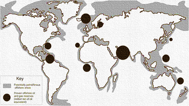
  • Give a geographical explanation of the distribution of off-shore oil reserves of the world. How are they different from the on-shore occurrences of oil reserves?

    Petroleum reserves are found in sedimentary basins, where organic matter is trapped under pressure. Offshore reserves account for ~30% of global crude oil production. Their distribution is linked to continental shelf geology, passive margins, and deep-water basins.

    Geographical distribution

    The Persian Gulf (Middle East)- result of the collision between the Arabian and Eurasian plates, which created perfect “anticline” traps for oil. Eg- Safaniya field (Saudi Arabia), largest offshore oil field in the world.

    The Gulf of Mexico (North America)- It is characterized by salt domes that trap oil in the surrounding porous rock.

    The North Sea (Europe)- Situated between the UK, Norway, and Denmark. This region is a rift basin, with deep depressions where organic matter could settle.

    The South Atlantic Margins (Brazil & West Africa)- formed when South America and Africa drifted apart.

    Southeast Asia & India- in the South China Sea and India’s Mumbai High and Krishna-Godavari (KG) Basin

    Difference between off-shore and on-shore oil reserves

    Implications of uneven distribution of mineral oils in the world

    Energy security challenges – Oil-deficient countries face high import bills and current account deficits. Eg- India imports ~85% of its crude oil requirement.

    Resource Curse in Oil-rich Nations (Paradox of Plenty) – Overdependence on oil leads to limited economic diversification. Eg- Venezuela’s economic crisis.

    Energy trade is one of the key drivers of global geopolitics. Eg- US sanctions on Russian and Iran oil trade

    Competition for oil resources leads to wars and regional instability. Eg- Gulf Wars, Saudi-Iran rivalry.

    Oil-rich regions face oil spills, land degradation, and marine pollution. Eg- Niger Delta pollution.

    Global Carbon Emissions – oil and gas industry is responsible for over 5 billion tonnes of CO2 equivalent in direct emissions annually (15% of total energy-related emissions)

    In the long run, reducing oil dependence through clean energy, strategic reserves, and diversified supply chains is essential for ensuring equitable and sustainable global development.

  • Discuss the distribution and density of population in the Ganga River Basin with special reference to land, soil and water resources.

    The Ganga River Basin houses around 43% of India’s population (600 million) in about 26% of its geographical area. The average population density exceeds 520 persons/km².

    Distribution and Density of Population

    Upper Ganga Basin

    Characterized by low density (approx. 150-300 persons/km²).

    Rugged terrain and steep slopes restrict large-scale habitation to river valleys like Dehradun and Haridwar.

    Middle Ganga Plain – “demographic heartland” with very high density (800-1,100+ persons/km²).

    Lower Ganga Plain – extremely high density (exceeding 1,000-1,300 persons/km²), particularly in the deltaic regions and the Kolkata Metropolitan Area.

    Impact of Land on Distribution and Density of Population

    Extensive level plains support agriculture, transport, and urban expansion. Eg- eastern Uttar Pradesh and north Bihar.

    A high proportion of cultivable land supports intensive agricultural activity. Eg- Rice-wheat belt of the middle Ganga plain.

    Deltaic plains – Urban and industrial concentration. Eg- Kolkata-Howrah region in the lower Ganga plain.

    Piedmont and Tarai zone – Forests converted into agricultural land increased settlement. Eg- Tarai region of Uttarakhand and Uttar Pradesh.

    Himalayan Foothills-In the Upper Basin (Uttarakhand), rugged terrain restricts population to valley floors. Eg- Dehradun and Haridwar

    Ease of Habitation-The vast, flat alluvial plains allow for the construction of dense transport networks. Eg- National Highway 19 corridor connects mega-cities like Delhi, Kanpur, and Kolkata.

    Gentle Slope-A gradient of barely 20cm/km facilitates large-scale urban sprawl. Eg- The rapid expansion of cities like Noida and Ghaziabad

    Doab Regions-The fertile land between two rivers (Doabs) shows the highest density. Eg- The Ganga-Yamuna Doab

    Impact of soil on distribution and density of population

    Alluvial Dominance-Over 70% of the basin is covered by nutrient-rich alluvium, supporting 80% of its population.

    Soil suitable for diverse crops – Rice, wheat, sugarcane, pulses and jute support a dense population. Eg- Jute cultivation in West Bengal delta.

    Khadar (New Alluvium)-Annually replenished by floods, these soils support intensive agriculture. Eg- North Bihar plains sustain a density of over 1,100 persons/km² due to its high productivity.

    Bhangar (Old Alluvium)-Stable, older soils support the wheat-sugar cane belt and high rural density of Western Uttar Pradesh.

    Multi-cropping Potential-Eg- Farmers in the Lower Ganga Basin (West Bengal) grow three rice crops (Aman, Aus, Boro), sustaining very high rural populations.

    Deltaic Silt-The nutrient-dense silt in the Sunderbans and Bengal delta supports high-intensity fishing and farming. Eg- High densities in districts like South 24 Parganas despite the risk of cyclones.

    Impact of water on distribution and density of population

    Perennial river system – Reliable water for domestic and agricultural use supports dense settlements. Eg- Kanpur on Ganga bank.

    Extensive canal irrigation supports agricultural intensification and increases rural density. Eg- Upper Ganga Canal in western Uttar Pradesh.

    Groundwater Availability-Eg- The widespread use of tubewells in the Bihar plains allows for dense human clusters away from the main river.

    Inland water transport supports urban growth. Eg- Eg- National Waterway-1 along the Ganga.

    Major Challenges

    Very high population pressure on land – Average landholding size in Bihar and eastern UP is less than 1 hectare.

    Frequent floods – Displacement and loss of livelihood. Eg- Annual floods in north Bihar.

    Groundwater depletion – Over-extraction for irrigation in western and central UP.

    Water pollution – Eg- Industrial and domestic waste in Kanpur-Varanasi stretch.

    Declining soil fertility due to overuse of fertilisers. Eg- Green Revolution areas of western UP.

    Unplanned urbanisation – Pressure on land and water resources

    Climate variability – Irregular monsoon and heat stress impact agriculture productivity and public health.

    Efficient land use planning, flood management, groundwater regulation, and soil conservation are essential for maintaining the region’s demographic and ecological balance.

    Society

    Salient Features
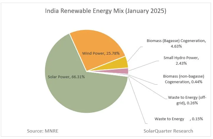
  • Explain briefly the ecological and economic benefits of solar energy generation in India with suitable examples.

    India has emerged as a global leader in solar energy with over 140 GW of installed solar capacity (Nov 2025) and ranks 3rd in the world in solar capacity and generation.

    Ecological Benefits

    Carbon Sequestration

    By replacing coal-fired thermal power, which is the primary source of CO-2 emissions. Every 1 GW of solar power reduces CO2 emissions by approximately 1.5 million tonnes annually.

    Supports India’s NDC targets – 500 GW non-fossil capacity by 2030 and net-zero by 2070.

    Water Conservation – Use 95% less water than thermal power plants. Shifting to solar saves roughly 2.5 liters of water per kWh generated.

    Preservation of Fragile Ecosystems – Installing panels on reservoirs reduces water evaporation and algae growth. Eg- Omkareshwar Floating Solar Park (Madhya Pradesh).

    Agrivoltaic Biodiversity – “Solar farming” allows crops to grow beneath panels, creating a micro-climate that reduces soil moisture loss.

    Reduction Air Pollution – Unlike fossil fuels, solar generation releases zero SOx, NOx, or particulate matter (PM 2.5).

    Soil Reclamation – Solar parks built on saline or degraded “wastelands,” prevent further soil erosion. Eg- Khavda Hybrid Park in the Rann of Kutch

    Transition to Circular Economy – Eg- Draft Solar Waste Management Rules mandate recycling of end-of-life panels.

    Protection of Glacial Regions – Eg- Solar projects in Ladakh (13 GW planned) can reduce black carbon deposits on glaciers, which otherwise accelerate melting.

    Economic Benefits

    Cost Savings for Households – Solar tariffs are lower compared to coal based power.

    Reduction in Energy Import Bill – Solar energy helped India save roughly $4.2 billion in fuel costs in 2024-25, strengthening the Current Account Balance.

    Boost to Domestic Manufacturing (PLI Scheme) – Solar manufacturing capacity jumped from 38 GW to 74 GW in 2025, attracting ₹52,900 crore in fresh private investment.

    Agricultural Income Diversification- Under PM-KUSUM Component A, farmers can earn income by installing solar plants on unproductive land.

    Attraction of Global FDI – 100% FDI under the automatic route has made India a top destination for ESG-focused global funds.

    Rural Electrification – Solar micro-grids provide 24/7 power to remote villages where grid extension is expensive.

    Infrastructure Development – Mega solar parks bring roads, water, and connectivity to previously isolated regions.

    Export Potential– India exported $1.5 billion worth of solar equipment in 2025.

    Challenges in Solar Energy Generation

    Intermittency and Storage Gap- shortage of Battery Energy Storage Systems (BESS)

    Land Acquisition Hurdles for Mega-parks

    Lack of grid connectivity

    Import dependency- India still imports over 90% of its wafers and ingots from China.

    Limited recycling infrastructure creates a toxic waste risk (lead and cadmium).

    Poor Financial Health of DISCOMs- delayed payments to solar developers and deterring investment.

    Steps Taken by Governments

    PM-Surya Ghar- Muft Bijli Yojana to solarize 1 crore households by 2027

    Solar Park Scheme- A target of 40 GW across 50+ parks by March 2026.

    PM-KUSUM- Solarizing over 30 million irrigation pumps.

    PLI Scheme- to boost domestic manufacturing of high-efficiency solar modules

    A balanced strategy focusing on decentralised solar, grid expansion, storage systems, and region-specific planning is essential to achieve Panchamrit Targets.

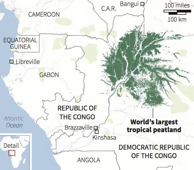
  • Cuvette Centrale: World’s Largest Tropical Peatland Complex

    Why in the News?

    The Democratic Republic of the Congo (DRC) has launched oil exploration over 124 million hectares of the Cuvette Centrale peatlands raising global ecological risk.

    About the Cuvette Centrale Peatland Complex:

    • Location: Central Congo Basin, spanning the Democratic Republic of the Congo and the Republic of Congo.
    • Size: Covers approximately 145,000–167,600 sq. km—larger than England and about 10% of the Congo Basin.
    • Peat Coverage: Around 40% of the region is underlain by peat—formed over 10,000 years due to flat terrain, rainforest climate, and slow-moving water.
    • Landscape: Features a mosaic of seasonal lakes, floating prairies, swamp forests, rivers, and grasslands.
    • Global Status: The world’s largest near-contiguous tropical peatland complex.

    Ecological Significance:

    • Carbon Storage: Holds about 30–30.6 gigatonnes of carbon—
      • Equal to 3 years of global fossil fuel emissions.
      • Nearly 15 years of U.S. emissions.
      • About 28% of global tropical peat carbon stock.
    • Climate Impact: Acts as a major carbon sink, critical for regulating global temperatures and mitigating climate change.
    • Biodiversity: Habitat for forest elephants, lowland gorillas, and rare plant species.
    • Local Importance: Sustains indigenous livelihoods and maintains regional water cycles.
    • Conservation Status: Recognized as a transnational Ramsar wetland site, highlighting its international ecological value.
    [UPSC 2024] One of the following regions has the world’s largest tropical peatland, which holds about three years’ worth of global carbon emissions from fossil fuels, and the possible destruction of which can exert a detrimental effect on the global climate. Which one of the following denotes that region?

    Options: (a) Amazon Basin (b) Congo Basin* (c) Kikori basin (d) Rio De La Plata Basin


  • Assessment of Water Resources of India, 2024 by CWC

    Why in the News?

    • The Central Water Commission (CWC) recently released its study titled ‘Assessment of Water Resources of India, 2024.
      • It estimated India’s average annual water availability from 1985 to 2023 at 2,115.95 billion cubic meters (BCM).

    Key Highlights of CWC’s ‘Assessment of Water Resources of India 2024’ Report:

    • Total Water Availability: India’s average annual water availability between 1985 and 2023 is estimated at 2,115.95 billion cubic meters (BCM).
    • Top 3 Basins in (annual water availability):
      • Brahmaputra Basin: 592.32 BCM
      • Ganga Basin: 581.75 BCM
      • Godavari Basin: 129.17 BCM
    • Bottom 3 Basins in (annual water availability):
      • Sabarmati Basin: 9.87 BCM
      • Pennar Basin: 10.42 BCM
      • Mahi Basin: 13.03 BCM
    • Comparison to Previous Assessment (2019):
      • The current figure of 2,115.95 BCM is higher than the 1,999.2 BCM estimated in 2019.
      • The increase is due to the inclusion of Bhutan’s contribution to the Brahmaputra basin and Nepal’s contribution to the Ganga basin.
    • Per Capita Water Availability:
      • Based on the 2019 study: 1,486 cubic meters for the year 2021.
      • For 2024, with the new data, the per capita availability is projected to be 1,513 cubic meters (based on a population of 1.398 billion).
      • Despite the increase, India remains under water stress (less than 1,700 cubic meters per capita).
    • Utilizable Water Resources:
      • The CWC estimates utilizable surface water at 690 BCM out of the total 1,999.2 BCM.
      • Smaller basins have a higher proportion of utilisable water compared to larger ones like the Brahmaputra sub-basin.

    About the Central Water Commission (CWC):

    • CWC was established in 1945 as the Central Waterways, Irrigation and Navigation Commission (CWINC) on the advice of Dr. B. R. Ambedkar.
    • Operates under the Ministry of Jal Shakti, Department of Water Resources, River Development, and Ganga Rejuvenation.
    • A statutory advisory body for water resource development and management.
    • Headquarters: New Delhi.
    • Chairman serves as the Ex-Officio Secretary to the Government of India.
    • Responsibilities include:
      • Control, conservation, and utilization of water resources.
      • Maintaining the National Register of Large Dams (NRLD).
      • Conducting hydrological surveys.
      • Handles surface water, while the Central Groundwater Board (CGWB) manages groundwater resources.
    • Wings:
      • Designs and Research (D&R) Wing.
      • River Management (RM) Wing.
      • Water Planning and Projects (WP&P) Wing.


    PYQ:

    [2020] Consider the following statements:

    1. 36% of India’s districts are classified as “overexploited” or “critical” by the Central Ground Water Authority (CGWA).

    2. CGWA was formed under the Environment (Protection) Act.

    3. India has the largest area under groundwater irrigation in the world.

    Which of the statements given above is/are correct?

    (a) 1 only

    (b) 2 and 3 only

    (c) 2 only

    (d) 1 and 3 only

  • Critical Minerals under iCET

    Why in the News?

    What are Critical Minerals?

    • Critical minerals are elements that are crucial to modern-day technologies and are at risk of supply chain disruptions.
    • These minerals are mostly used in making electronic equipment such as mobile phones, computers, batteries, electric vehicles, and green technologies like solar panels and wind turbines.
    • Many of these are required to meet the manufacturing needs of green technologies, high-tech equipment, aviation, and national defence.

    List of critical minerals includes:

    The centre has released a list of 30 critical minerals for India in 2023:

    1. Identified Minerals: Antimony, Beryllium, Bismuth, Cobalt, Copper, Gallium, Germanium, Graphite, Hafnium, Indium, Lithium, Molybdenum, Niobium, Nickel, Platinum Group elements (PGE), Phosphorous, Potash, Rare Earth Elements (REE), Rhenium, Silicon, Strontium, Tantalum, Tellurium, Tin, Titanium, Tungsten, Vanadium, Zirconium, Selenium and Cadmium.
    2. Fertilizer Minerals: Two minerals critical for fertilizer production, phosphorous and potash, are also included in the above list.

    Critical Mineral Blocks in India

    • Distribution: There are 20 blocks spread across eight states, including Tamil Nadu, Odisha, Bihar, Uttar Pradesh, Gujarat, Jharkhand, Chhattisgarh, and Jammu & Kashmir.
    • Types of Licenses: Four blocks are for a Mining License (ML), allowing immediate mining post-clearance. The remaining 16 blocks are for a Composite License (CL), permitting further exploration before potentially converting to an ML.
    • Approvals Required: Licensees must obtain various approvals, including forest clearance and environmental clearance.
    • Forest Land: Approximately 17% of the total concession area, or 1,234 hectares, is forest land.

    India’s Critical Mineral Imports

    • Lithium Imports: In FY23, India imported 2,145 tonnes of lithium carbonate and lithium oxide, costing Rs 732 crore.
    • Nickel and Copper Imports: The country imported 32,000 tonnes of unwrought nickel and 1.2 million tonnes of copper ore, costing Rs 6,549 crore and Rs 27,374 crore, respectively.
    • Import Dependence: India relies entirely on imports for lithium and nickel, and 93% for copper.

    Country-wise dependence:

    1. China: India heavily relies on China for the import of critical minerals like lithium, cobalt, nickel, and graphite.
    2. Australia: India is actively engaged with Australia for acquiring mineral assets, particularly lithium and cobalt, to secure its supply chain for critical minerals.
    3. Argentina, Bolivia, and Chile: India is engaging with these countries, known for their reserves of battery metals like lithium and cobalt, to diversify its sources for critical minerals.

    India’s Strategic Mineral Initiatives

    • Amendments to the Mines and Minerals (Development and Regulation) Act, 1957 support expanded exploration.
    • Establishment of Khanij Bidesh India Ltd. (KABIL) with equity from National Aluminium Company Ltd, Hindustan Copper Ltd, and Mineral Exploration and Consultancy Ltd for global mineral asset acquisition.

    International Collaborations and Partnerships

    • India joined the U.S.-led mineral security partnership to secure critical mineral supply chains.
    • Creation of an India-U.S. advanced materials research forum to foster collaboration in universities, laboratories, and private sectors.
    • Bilateral technology collaboration on neodymium-iron-boron and studies on minerals like lithium, titanium, gallium, and vanadium.

    Back2Basics: Indo-US Comprehensive Economic and Trade Agreement (iCET)

    Details
    Initiation Announced in May 2022, officially launched in January 2023
    Management Overseen by the National Security Councils of India and the US
    Objectives Enhance bilateral cooperation in critical and emerging technologies
    Focus Areas of the Initiative
    1. AI Research Agency Partnership
    2. Defense Industrial and Technological Cooperation
    3. Innovation Ecosystems
    4. Semiconductor Ecosystem Development
    5. Cooperation on Human Spaceflight
    6. Advancement in 5G and 6G Technologies
    Key Achievements
    • Quantum Coordination Mechanism
    • Public-private dialogues on telecommunications and AI
    • MoU on semiconductor supply chain
    • Defense industrial cooperation roadmap
    Upcoming Initiatives
    • Finalization of major jet engine deal
    • Launch of India-US Defence Acceleration Ecosystem (INDUS-X)
    • Strategic Trade Dialogue establishment


    PYQ:

    [2019] With reference to the management of minor minerals in India, consider the following statements:

    1. Sand is a ‘minor mineral’ according to the prevailing law in the country.
    2. State governments have the power to grant mining leases of minor minerals, but the powers regarding the formation of rules related to the grant of minor minerals lie with the Central Government.
    3. State Governments have the power to frame rules to prevent illegal mining of minor minerals.

    Which of the statements given above is/are correct?

    (a) 1 and 3

    (b) 2 and 3

    (c) 3 only

    (d) 1, 2 and 3

  • PREMIUM – Travelling the Regions of South America

    PREMIUM – Travelling the Regions of South America

    Why in the News?

    South America, known for its diverse landscapes and cultures, also harbors several disputed territories, each with its own historical, geopolitical, and economic significance. These disputes often arise from conflicting territorial claims, historical grievances, or resource-rich areas. 

    Diverse Landscapes of South America:

    • The Pacific Coastal Strip:
      • Between the ocean and the Andes mountain Range.
      • The coastline of South America is smooth and regular. At the river mouths, some inlets are used as harbors. The southwestern coast of the continent has fiords or deep inlets of the sea.
    • Andes Mountain Range:
      • The Andes stretch through the entire continent, running in the north-south direction from the Isthmus of Panama to the Strait of Magellan. The second-highest mountain system in the world.
      • Mount Aconcagua (an extinct volcano lies in Argentina)
      • Mount Ojas del Salado is the highest active volcano in the world of Argentina.
      • Part of seven countries: Venezuela, Colombia, Ecuador, Bolivia, Peru, Chile, and Argentina.
      • They form a chain of ranges and knots with enclosed intermontane plateaus namely in Ecuador and Bolivia.
      • Being part of the Pacific Ring of Fire, there are many volcanoes and frequent earthquakes in this region. Mount Cotopaxi and Mount Chimborazo are active volcanic peaks, which is the highest peak in South America.
    • About the Amazon River:
      • It is the world’s largest and second-longest (6,400 km) river in the world after the Nile.
      • Its journey begins high in the Andes Mountains. The river then makes its way east through thousands of miles of rainforests and lowlands until it empties into the Atlantic Ocean on the northeastern coast of Brazil
      • Its watershed spans the countries of Brazil, Peru, Ecuador, Colombia, Venezuela, and Bolivia.
      • It has more than 1,100 tributaries, which include the rivers like the Rio Negro, the Madeira River, and the Xingu River, etc.
      • The Amazon Rainforest, which represents about half of the Earth’s remaining rainforest, also constitutes its single largest reserve of biological resources.
      • It is sometimes referred to as the “lungs of the Earth” due to its role in regulating the planet’s oxygen and carbon cycles.

    Disputed Areas in South America

    Countries Involved Key Points Geographical Features
    Gulf of Venezuela Colombia, Venezuela
    • Inlet of the Caribbean Sea is Disputed over islands such as Los Monjes Archipelago due to Fishing rights and potential oil reserves.
    • Interpretation disputes regarding the 1941 Treaty of Delimitation            
    • Recent tensions over maritime confrontations and oil exploration activities.
    Surrounded by coastal mountain ranges with waters fed by several rivers
    Essequibo Region Guyana, Venezuela
    • Covers two-thirds of Guyana’s territory Historical grievances claimed by Venezuela.         
    • Recent oil discoveries raising tensions; ICJ case filed by Guyana.
    • Essequibo River flows through this region.
    Diverse landscapes including rainforests, savannahs, and mountains with the Essequibo River
    Atacama Desert Peru, Chile
    • Extremely Arid desert region            
    • War of the Pacific led to Chile’s control           
    • Valuable mineral resources contribute to disputes            
    • Bilateral talks and arbitration proposals for settlement
    Bordered by the Andes Mountains and the Pacific Ocean with salt flats, sand dunes, and volcanic formations
    Falkland Islands (Malvinas) Argentina, UK
    • Sovereignty disputes since 1833           
    • Economic interests include fisheries, tourism, and potential oil reserves           
    • Diplomatic efforts and UN resolutions for resolution
    Consists of two main islands with rugged coastlines and low mountains
    Darien Gap Colombia, Panama
    • Dense jungle terrain separating North and South America            
    • Challenges in illegal immigration discussions            
    • Characterized by dense rainforests, swamps, and mountains
    Part of the Darien National Park with dense rainforests, mangroves, and steep mountain slopes
    Arroyo de la Invernada or Rincon de Artigas… Brazil, Uruguay
    • Dispute over the Invernada River region near Masoller            
    • UN does not officially recognize the claim            
    • 237 km2 region with significant natural resources            
    • Efforts to resolve through bilateral talks and international mediation
    Rolling hills, grasslands, and small rivers with the Invernada River
    New River Triangle (Tigri Area) Suriname, Guyana
    • Disputed region within the Guiana Highlands            
    • Conflicting claims over territory interpretation of historical treaties and boundaries
    Dense rainforests, mountain ranges, and numerous rivers
    Isla Brasilera/Ilha Brasileira Brazil, Uruguay
    • Uruguay claims ownership of Isla Brasilera            
    • Strategically located near the tripoint with Argentina            
    • Efforts to resolve through diplomatic negotiations and legal arguments
    Small island located in the Uruguay River with lush vegetation
    Isla Suarez/Ilha de Guajara-mirim Bolivia, Brazil
    • Located in the Rio Mamore as a border between Bolivia and Brazil           
    • Economically dependent on Guajara-Mirim, Brazil            
    • Treaty signed in 1958 maintains the status quo            
    • Challenges of border management in riverine environments
    Riverine island characterized by tropical vegetation and wetlands
    Southern Patagonian Ice Field Argentina, Chile
    • Spanning parts of Argentina and Chile            
    • Border demarcation remains undefined in certain areas           
    • Bilateral efforts for resolution include scientific cooperation and mapping projects
    Vast expanse of ice and snow covering rugged mountain ranges and deep valleys
    Lithium Triangle  Argentina, Bolivia, and Chile
    • It is characterized by various salt pans or salars, concentrated along the Atacama Desert and adjacent arid regions.
    • The Salar de Atacama in Chile boasts the highest lithium concentration (0.15% by weight) among all brine sources worldwide. 
    • Argentina boasts more than half of the world’s total lithium resources and holds the distinction of having the 2nd-largest lithium resources, the 3rd-largest lithium reserves, and the 4th-largest lithium production in the world.
    • India’s KABIL (Khanij Bidesh India Ltd) has announced an investment of ₹211 crore ($25.712 million) over five years for exploration stage activities in five lithium blocks in the Fiambala area of Argentina.
    Key reserves of Lithium include:

    1. Uyuni (Bolivia): This salt flat is not only the world’s largest salt flat but also contains significant lithium reserves.  
    2. Atacama (Chile): Located in the Atacama Desert, Salar de Atacama is home to one of the largest lithium reserves globally. 
    3. Hombre Muerto (Argentina): This salt flat in northwestern Argentina also hosts lithium extraction operations.


    Note: Bolivia and Paraguay are land-locked countries in South America

    PYQ:

    [2013] “Climate is extreme, rainfall is scanty and the people used to be nomadic herders.”  

    The above statement best describes which of the following regions?

    (a) African Savannah

    (b) Central Asian Steppe

    (c) South American Tropical

    (d) Siberian Tundra


  • What are Critical Minerals?

    Why in the news?

    • India is looking for cobalt and other critical minerals in Zambia, Namibia, Congo, Ghana and Mozambique. It is still engaging with Australia for lithium blocks.
    • Critical minerals, including lithium and cobalt, are crucial for technology, manufacturing and other industries.

    What are Critical Minerals?

    • Critical minerals are elements that are crucial to modern-day technologies and are at risk of supply chain disruptions.
    • These minerals are mostly used in making electronic equipment such as mobile phones, computers, batteries, electric vehicles, and green technologies like solar panels and wind turbines.
    • Many of these are required to meet the manufacturing needs of green technologies, high-tech equipment, aviation, and national defence.

    List of critical minerals includes:

    The centre has released a list of 30 critical minerals for India in 2023:

    1. Identified Minerals: Antimony, Beryllium, Bismuth, Cobalt, Copper, Gallium, Germanium, Graphite, Hafnium, Indium, Lithium, Molybdenum, Niobium, Nickel, Platinum Group elements (PGE), Phosphorous, Potash, Rare Earth Elements (REE), Rhenium, Silicon, Strontium, Tantalum, Tellurium, Tin, Titanium, Tungsten, Vanadium, Zirconium, Selenium and Cadmium.
    2. Fertilizer Minerals: Two minerals critical for fertilizer production, phosphorous and potash, are also included in the above list.

    Critical Mineral Blocks in India

    • Distribution: There are 20 blocks spread across eight states, including Tamil Nadu, Odisha, Bihar, Uttar Pradesh, Gujarat, Jharkhand, Chhattisgarh, and Jammu & Kashmir.
    • Types of Licenses: Four blocks are for a Mining License (ML), allowing immediate mining post-clearance. The remaining 16 blocks are for a Composite License (CL), permitting further exploration before potentially converting to an ML.
    • Approvals Required: Licensees must obtain various approvals, including forest clearance and environmental clearance.
    • Forest Land: Approximately 17% of the total concession area, or 1,234 hectares, is forest land.

    India’s Critical Mineral Imports

    • Lithium Imports: In FY23, India imported 2,145 tonnes of lithium carbonate and lithium oxide, costing Rs 732 crore.
    • Nickel and Copper Imports: The country imported 32,000 tonnes of unwrought nickel and 1.2 million tonnes of copper ore, costing Rs 6,549 crore and Rs 27,374 crore, respectively.
    • Import Dependence: India relies entirely on imports for lithium and nickel, and 93% for copper.

    Country-wise dependence:

    1. China: India heavily relies on China for the import of critical minerals like lithium, cobalt, nickel, and graphite.
    2. Australia: India is actively engaged with Australia for acquiring mineral assets, particularly lithium and cobalt, to secure its supply chain for critical minerals.
    3. Argentina, Bolivia, and Chile: India is engaging with these countries, known for their reserves of battery metals like lithium and cobalt, to diversify its sources for critical minerals.


    PYQ:

    2019: With reference to the management of minor minerals in India, consider the following statements:

    1. Sand is a ‘minor mineral’ according to the prevailing law in the country.
    2. State governments have the power to grant mining leases of minor minerals, but the powers regarding the formation of rules related to the grant of minor minerals lie with the Central Government.
    3. State Governments have the power to frame rules to prevent illegal mining of minor minerals.

    Which of the statements given above is/are correct?

    1. 1 and 3
    2. 2 and 3
    3. 3 only
    4. 1, 2 and 3


    Practice MCQ:

    Consider the following statements:

    1. Critical minerals are those elements which are crucial to modern-day technologies and are at risk of supply chain disruptions.
    2. India has notified 30 elements in the Critical Minerals List.
    3. Fertilizer minerals Phosphorous and potash are also included in the Critical Minerals List.

    How many of the given statements is/are correct?

    1. One
    2. Two
    3. Three
    4. None
  • An expansive land management policy is overdue


    Mains Pyq:  Discuss the role of land reforms in agricultural development. Identify the factors that were responsible for the success of land reforms in India. (UPSC CSE 2016)


    Prelims Pyq: With reference to land reforms in independent India, which one of the following statements is correct?  (UPSC CSE 2019)

    1. The ceiling laws were aimed at family holdings and not individual holdings.
    2. The major aim of land reforms was providing agricultural land to all the landless.
    3. It resulted in cultivation of cash crops as a predominant form of cultivation.
    4. Land reforms permitted no exemptions to the ceiling limits. 

    India lost 2.5 per cent of GDP to land degradation

    Context:

    Land is central to all human activities. It provides ecological, economic, social, and cultural services. But this multi-dimensional character of land is often overlooked in land management practices, resulting in excessive stress, land degradation, and environmental draw down.

    What do various reports highlight about land degradation and management?

    • Global Losses Due to Land Degradation: The annual losses of ecosystem services due to land degradation have been estimated at a staggering $6 trillion globally. This highlights the significant economic impact of neglecting land management.
    • UN Convention to Combat Desertification (COP14): The COP14 held in New Delhi in 2019 focused on discussing the problem of land degradation experienced by different countries. It emphasized the need to achieve land degradation neutrality, indicating the urgency of addressing this issue on a global scale.
    • Intergovernmental Panel on Climate Change (IPCC) Special Report: The IPCC’s special report on ‘Climate Change and Land’ in 2019 underscored the importance of country-level stocktaking of land management practices. It recommended near- and long-term actions aimed at reducing competition for land while maximizing co-benefits and minimizing negative impacts on key ecosystem services.
    • Food and Agriculture Organization (FAO) Report: The FAO’s report titled ‘State of the World’s Land and Water Resources for Food and Agriculture: The System at Breaking Point’ in 2021 emphasized the urgent need to prioritize land, soil, and water management. It highlighted the neglected area of public policy and human welfare, stressing the importance of caring for the long-term future of land resources.

    What are the challenges in land management in India?

    • Limited Geographical Area, High Population Density: Despite having only 2.4% of the world’s geographical area, India accommodates more than 17% of the world population. This high population density exacerbates land management issues, increasing pressure on available land resources.
    • Degraded Land: Approximately 30% of India’s total geographical area is degraded land. This degradation reduces agricultural productivity, diminishes ecosystem services, and contributes to environmental issues such as soil erosion and desertification.
    • Competition for Arable Land: With around 55% of India’s total geographical area classified as arable land, there is intense competition among farmers and various sectors for access to agricultural land. This competition is further fueled by the demand for land due to rapid urbanization, infrastructure development, and industrial expansion.
    • Urbanization and Infrastructure Development: Rapid urbanization and infrastructure development are leading to the conversion of agricultural land into urban areas, resulting in the loss of fertile land and natural habitats. This trend contributes to land use conflicts, escalating land prices, and changing land rights.
    • Environmental Degradation and Loss of Ecological Functions: The encroachment on natural areas and degradation of land lead to the loss of ecological functions and biodiversity. This not only affects the livelihood opportunities of people dependent on environmental resources but also undermines the buffering capacity of natural ecosystems against disasters such as floods, droughts, and pollution.
    • Climate Change Impacts: Climate change exacerbates land management challenges by altering precipitation patterns, increasing the frequency of extreme weather events, and contributing to temperature rise. These changes further stress land resources, exacerbating land degradation and impacting agricultural productivity.

    What is the current status of land management in India?

    • Sectoral Approach and Administrative Complexity: Land management practices in India are predominantly sectoral, with different government departments implementing their own approaches. This fragmented governance structure leads to administrative complexity and coordination challenges among various stakeholders involved in land management.
    • State Government Jurisdiction: Land management falls under the purview of state governments in India. While this decentralization allows for localized decision-making, it can also lead to inconsistencies in policies and regulations across different regions.
    • Privately Owned Cultural Land: A significant portion of land in India, particularly cultural land, is privately owned. Land-use decisions are constitutionally vested with the owner, which further complicates the regulatory framework and implementation of land management practices.

    Status of Adoption and Implementation Land management practices:

    • Knowledge Gaps: Limited understanding of sustainable land management practices and their implications.
    • Short-Term Planning Bias: Emphasis on short-term gains over long-term sustainability in land-use planning.
    • Fragmented Approach: Lack of coordination among government agencies and stakeholders, leading to disjointed efforts in land management.
    • Lack of Action for Unforeseen Events: Inadequate preparedness and response mechanisms for unforeseen events such as natural disasters or climate change impacts.
    • Regulatory Barriers: Complex regulatory frameworks and bureaucratic hurdles that impede effective land management initiatives.

    What suggestions does this article give for addressing land management challenges in India?

    • Establishment of Multi-Stakeholder Platforms: Setting up multi-stakeholder platforms at the district and sub-district levels to bring together farmers, land managers, policymakers, civil society organizations, business leaders, and investors. This collaborative approach aims to facilitate sectoral integration and collective decision-making in land management.
    • Activation of District Planning Committees: Utilizing Article 243ZD (1) of the Constitution, which provides for district planning committees, to consolidate plans from panchayats and municipalities. These committees can be activated to prepare comprehensive land management plans covering both agricultural and non-agricultural sectors.
    • Adoption of a Landscape Approach: Embracing a landscape approach to land management, which considers the interconnectedness of various land uses and ecosystems. This approach provides deep insights into the potential of land and facilitates the allocation and reallocation of land for appropriate uses. It also enables evaluation, negotiation, trade-offs, and decision-making processes.
    • Integration of Climate-Smart Strategies: Incorporating climate-smart strategies into land management practices to address climate objectives, enhance agricultural production, improve local livelihoods, and promote the conservation of biodiversity. This entails implementing measures that mitigate climate change impacts and enhance resilience in land use planning and management.


    Case study of netherland for value addition 

    • Room for the River Program initiated by the Dutch government in 2006 to address flood risks.
    • Program adopts an integrated approach to water and land management, recognizing interconnectedness of river systems, floodplains, and landscapes.
    • Emphasizes nature-based solutions like creating floodplains, restoring wetlands, and constructing bypass channels.
    • Stakeholder engagement crucial for success, involving local communities, landowners, and stakeholders.
    • Aims for resilient landscapes, employing adaptive management for flexible responses to changing environmental conditions.

    In conclusion, effective land management is paramount for sustainable development, global stability, and environmental resilience. By embracing integrated approaches, nature-based solutions, and community engagement, India can address its land management challenges and pave the way for a more sustainable future. It is imperative for policymakers to prioritize these strategies, fostering collaboration and adaptability to safeguard India’s landscapes for generations to come.


  • Centre identifies 30 critical minerals: Why, how, and importance of the exercise

    minerals

    Central Idea

    • In a strategic move, the Indian government has recognized the importance of 30 critical minerals, including lithium, cobalt, nickel, graphite, tin, and copper, which play a crucial role in the country’s economic development and national security. These minerals are essential for various sectors such as clean technologies, information and communication technologies, and advanced manufacturing inputs.

    *Relevance of the topic:

    *As countries shift towards clean energy and digital economies, critical and rare earth minerals are essential for driving this transition

    *Dependence on other nations for procuring these resources can pose significant risks to the economy and strategic autonomy.

    *Also keep an eye on the reserves of these critical minerals. For example, Vast Lithium deposits discovered in the Himalayan region of Kashmir. A 5.9-million-ton lithium deposit was discovered in the Reasi district by the Geological Survey of India

    Background

    • Previous efforts have been made to identify critical minerals in India, including a 2011 initiative by the Planning Commission (now NITI Aayog).
    • This initiative emphasized the importance of ensuring the availability of mineral resources for industrial growth through planned exploration and management of existing resources. From 2017 to 2020, the country also focused on the exploration and development of rare earth elements.
    • The latest exercise was triggered by India’s international commitments to reduce carbon emissions and transition towards clean energy sources

    Major Critical Minerals and its applications

    • Graphite: Graphite is extensively used in the manufacturing of electric vehicle (EV) batteries. It is a key component in the anode of lithium-ion batteries, which power EVs and several portable electronic devices.
    • Lithium: Lithium is another essential mineral in the production of EV batteries. Lithium-ion batteries are widely used in electric vehicles, providing them with energy storage capacity. Lithium is also utilized in other applications, such as renewable energy storage systems.
    • Cobalt: Cobalt is a critical mineral required for the production of lithium-ion batteries used in electric vehicles. It enhances the stability and performance of the batteries. Additionally, cobalt finds applications in aerospace, communications, and defense industries. It is used in manufacturing fighter jets, drones, and other critical equipment.
    • Rare Earth Minerals: Rare earth minerals, although required in trace amounts, play a significant role in the manufacturing of semiconductors and high-end electronics. These minerals include elements like neodymium, dysprosium, and praseodymium, which are crucial for producing magnets used in electric motors, wind turbines, and other advanced technology applications.
    • Nickel: Nickel is another essential component in lithium-ion batteries, especially those used in electric vehicles. It helps enhance battery performance and energy density. Nickel is also utilized in various other industries, including aerospace and defense.

    Three-stage Assessment for identification of critical minerals in India

    1. In the first stage, strategies of various countries like Australia, the USA, Canada, UK, Japan, and South Korea were analyzed. Sixty-nine elements/minerals that were considered critical by these major global economies were shortlisted. Domestic initiatives were also given due importance.
    2. The second stage involved inter-ministerial consultations with various ministries to identify minerals critical to their sectors. Valuable inputs and suggestions were received from ministries such as Power, Atomic Energy, New and Renewable Energy, Fertilizers, Science and Technology, Pharmaceuticals, and NITI Aayog.
    3. The third stage aimed to develop an empirical formula for evaluating mineral criticality. This stage drew inspiration from the European Union’s methodology, which considers economic importance and supply risk as two major factors. Based on this comprehensive assessment process, a list of 30 critical minerals for India was finalized.

    Importance of Establishing a Specialized Agency

    • The committee responsible for identifying critical minerals emphasized the need to establish a National Institute or Centre of Excellence for critical minerals, similar to Australia’s CSIRO.
    • This proposed center would periodically update the list of critical minerals, develop a critical mineral strategy, and execute functions essential for the development of an effective value chain in the country.

    Significance of independent source of Critical Minerals and its impact

    • Key Industry Enablers: Critical minerals are fundamental components in industries such as clean energy, electronics, transportation, defense, and manufacturing. They enable the production of advanced technologies, including electric vehicles, renewable energy systems, high-tech electronics, and communication devices. Without a stable supply of critical minerals, these industries would face significant challenges in meeting the growing global demand for their products.
    • Technological Advancements: Critical minerals are crucial for driving technological advancements and innovation. They provide the necessary raw materials for developing and improving clean technologies, energy storage systems, telecommunications devices, advanced electronics, and defense technologies. Access to critical minerals supports the development of cutting-edge technologies, enhances competitiveness, and fosters sustainable practices in various sectors.
    • Clean Energy Transition: Critical minerals play a pivotal role in the transition to clean energy sources. Minerals like lithium, cobalt, nickel, and rare earth elements are vital for the production of high-performance batteries used in electric vehicles and renewable energy storage systems. By ensuring a stable supply of these minerals, countries can accelerate the adoption of clean energy technologies, reduce greenhouse gas emissions, and mitigate the impact of climate change.
    • Economic Growth and Job Creation: Critical minerals contribute to economic growth by supporting industries that generate employment opportunities and foster innovation. Domestic production and processing of critical minerals create jobs across the entire value chain, including exploration, mining, processing, manufacturing, and research and development. By developing a robust critical minerals sector, countries can stimulate economic growth, enhance competitiveness, and reduce dependence on foreign imports.
    • National Security: Dependence on foreign sources for critical minerals can pose risks to national security. Disruptions in the supply chain due to geopolitical factors, trade conflicts, or market fluctuations can significantly impact industries crucial for defense, infrastructure, and strategic sectors. By identifying and developing domestic sources of critical minerals, countries can enhance their resilience, reduce vulnerabilities, and safeguard national security interests.
    • Sustainable Resource Management: The identification and sustainable management of critical minerals contribute to responsible resource utilization and environmental stewardship. By ensuring responsible mining practices, promoting recycling and circular economy approaches, and minimizing the environmental impact of mineral extraction and processing, countries can meet their mineral needs while addressing social, environmental, and governance concerns.

    Conclusion

    • The identification of critical minerals is a strategic move by the Indian government towards economic development and national security. The country can learn from global practices while leveraging domestic and international collaborations to secure critical mineral resources and accelerate its growth in sectors like clean technologies and advanced manufacturing.

    Also read:

    Big Lithium find: Risks and Rewards