Mains Ready By December. Smash Mains & Smash PYQ Admissions Open

GS Paper: GS3-18.Conservation, Environmental Pollution and Degradation, Environmental Impact Assessment.

  • Eco-ducts or Eco-bridges and their significance

    Ramnagar Forest Division in Nainital district, Uttarakhand, recently built its first eco-bridge for reptiles and smaller mammals.

    Q.Discuss how Eco-ducts or eco-bridges provide the best alternative for wildlife connectivity which is disrupted because of manmade highways. Also, discuss various challenges in building such bridges.

    What are Eco-bridges?

    • Eco-ducts or eco-bridges aim to enhance wildlife connectivity that can be disrupted because of highways or logging.
    • These include canopy bridges (usually for monkeys, squirrels and other arboreal species); concrete underpasses or overpass tunnels or viaducts (usually for larger animals); and amphibian tunnels or culverts.
    • Usually, these bridges are overlaid with planting from the area to give it a contiguous look with the landscape.

    Why need such bridges?

    • There are many roadkills on this route, especially of reptiles such as the monitor lizard.
    • The bridge is an awareness-building mechanism for this very congested tourist route.
    • These bridges are a way to see how we can preserve the ecosystem necessary for reptiles that feed on insects, for snakes that feed on reptiles, and for eagles that feed on snakes.

    Need of the hour

    • A 2020 study by the Wildlife Institute of India (WII) noted that nearly 50,000 km of road projects have been identified for construction over the next five to six years.
    • Many highways are being upgraded to four lanes.
    • The National Tiger Conservation Authority had identified three major sites that were cutting across animal corridors.
    • These including National Highway 37 through the Kaziranga-Karbi Anglong landscape in Assam, and State Highway 33 through the Nagarhole Tiger Reserve in Karnataka.

    Some considerations

    • The span and distribution of eco-bridges should depend on animal movement patterns.
    • The bigger bridges will see sambar, spotted deer, nilgai, wild pig using them, while for tigers or leopards if the bridge is 5m or 500 m, it doesn’t bother them.
    • But some animals like the deers, which prefer closed habitats, need smaller bridges.

    Some successes

    • The observation on NH 44, which intersects Kanha-Pench and Pench-Navegaon-Nagzira corridors in various sections, is a success.
    • With five animal underpasses and four minor bridges on the 6.6-km road within the forests, it’s one of India’s success stories.

    Such bridges in news

    • One of the largest underpasses – 1.4km – for animal conservation in India is being built along the Madhya Pradesh-Maharashtra border.
    • Other proposals include the Chennai-Bangalore National Highway, in the Hosur-Krishnagiri segment, near reserve forests for elephant crossings, and in the Tadoba-Andhari Tiger Reserve in Chandrapur, Maharashtra.
  • Jadav Payeng: The Forest Man of India

    Jadav Payeng, known as ‘The Forest Man of India’, takes us through his journey of grit that saw a desert turning into a forest. His story is been depicted through an upcoming trilingual film.

    We knew about the mountain man in India. We have also had the Forest Man of India who is also a living inspiration for successful afforestation. We can quote such examples in essays very well.

    Who is Jadav Payeng?

    • Jadav “Molai” Payeng (born 1963) is an environmental activist and forestry worker from Majuli Island popularly known as the Forest Man of India.
    • He was born in the indigenous Mising tribe of Assam.
    • Over the course of several decades, he has planted and tended trees on a sandbar of the river Brahmaputra turning it into a forest reserve.
    • The forest, called Molai forest after him is located near Kokilamukh of Jorhat, Assam, India and encompasses an area of about 1,360 acres / 550 hectares.
    • In 2015, he was honoured with Padmashri, the fourth highest civilian award in India.

    His work

    • The forest, which came to be known as Molai forest, now houses Bengal tigers, Indian rhinoceros, and over 100 deer and rabbits.
    • Molai forest is also home to elephants and several varieties of birds, including a large number of vultures.
    • Bamboo covers an area of over 300 hectares.
  • World Heritage Irrigation Structure (WHIS) Sites

    Four sites in India have received the World Heritage Irrigation Structure (WHIS) tag this year.

    Try this PYQ:

    Q.The FAO accords the status of ‘Globally Important Agricultural Heritage Systems (GIAHS)’ to traditional agricultural systems. What is the overall goal of this initiative?

    1. To provide modern technology, training in modern farming methods and financial support to local communities of identified GIAHS so as to greatly enhance their agricultural productivity.
    2. To identify and safeguard eco-friendly traditional farm practices and their associated landscapes, agricultural biodiversity and knowledge systems of the local communities.
    3. To provide Geographical Indication status to all the varieties of agricultural produce in such identified GIAHS.

    Select the correct answer using the code given below:

    (a) 1 and 3 only

    (b) 2 only

    (c) 2 and 3 only

    (d) 1, 2 and 3

    World Heritage Irrigation Structure (WHIS)

    • The International Commission on Irrigation and Drainage (ICID) annually recognizes irrigation structures of international significance like UNESCO’s World Heritage Sites.
    • The recognition is aimed at recognizing and tracing the history of and understanding the evolution of irrigation in civilizations across the world.
    • It also aims at understanding the philosophy and wisdom on sustainable irrigation from these structures and to preserve them for posterity.

    Criteria for consideration

    • Major criteria for WHIS entail that a structure should be more than 100 years old, should be functional, achieving food security and have archival value.
    • Each site is evaluated based on its merits first by the state government.
    • The proposal is then sent to the Centre and a team from CWC carries out an on-ground survey to verify details.

    Which are the Indian sites?

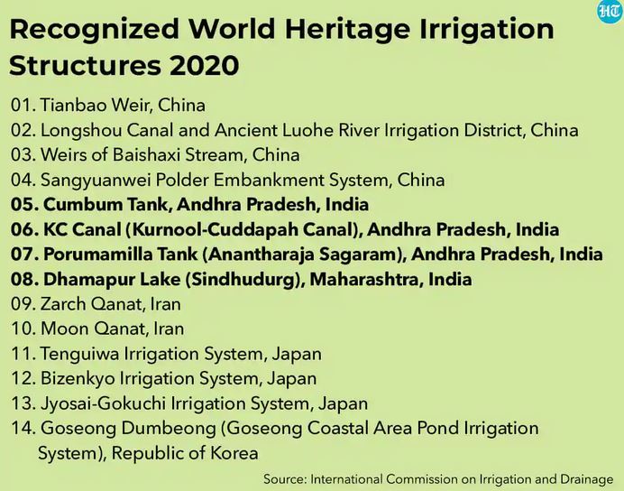
    • The sites are Cumbum Tank, Kurnool-Cuddapah Canal, Porumamilla Tank (Anantharaja Sagaram) in Andhra Pradesh and 490-year-old Dhamapur Lake in Maharashtra’s Sindhudurg district.
    • In 2018, Pedda Cheru Tank in Kamareddy district and Sadarmat Anicut in Nirmal district, both in Telangana, were named as WHIS sites.

    Other sites

    • The rest include Tianbao Weir in China at number one followed by Longshou Canal and ancient Luohe river irrigation district, China.
    • It also includes Zarch and Moon Qanat both in Iran and Tenguiwa, Bizenkyo and Jyosai Gokuchi irrigation systems in Japan with Goseong Dumbeong in the Republic of Korea.

    About ICID

    • The ICID, established in 1950 is a leading scientific, technical, international not-for-profit, non-governmental organization.
    • It is a professional network of experts from across the world in the field of irrigation, drainage, and flood management.
    • The main mission is to promote ‘Sustainable agriculture water management’ to achieve ‘Water secure world free of poverty and hunger through sustainable rural development’.
    • ICID mission covers the entire spectrum of agricultural water management practices ranging from rainfed agriculture to supplemental irrigation, land drainage, deficit irrigation to full irrigation, etc.
  • The Paris agreement is no panacea

    The article highlights the fact that the provisions of the Paris Agreement would not be enough to avert the catastrophic and irreversible changes resulting from the global emissions. 

    Past efforts for environmental protection

    • The most hopeful time for global cooperation in protection of the planet was between the time of the Stockholm Conference (1972) and the time of the Rio Conference (1992).
    •  Scientific evidence about role anthropogenic emission in global warming led to political initiatives to harmonise development and environment.
    • The historic consensus in Rio led to the adoption of the UN Framework Convention on Climate Change (UNFCC).
    • A distinction was made between the “luxury emissions” of the developed countries and the survival emissions of the developed countries, which were allowed to increase.
    • Moreover, a huge financial package was approved to develop environment-friendly technologies in developing countries.

    Copenhagen Accord: Abandonment of Rio Principles

    • After the adoption of UNFCC, Conference of the Parties was held in Berlin in 1995 where developed countries backed off from their commitments.
    • Though the G-77 was split, the Rio principles were maintained.
    • The Kyoto Protocol enshrined the Rio principles.
    • It fixed emission targets for developed countries and a complex set of provisions was included to satisfy their interests.
    • The end of the Kyoto Protocol and the abandonment of the spirit of the Rio principles were reflected in the Copenhagen Accord (2009).
    • Argument given was that a global climate action plan would be possible only if all reductions of the greenhouse gases were made voluntary.

    Paris Agreement: Making emission reduction voluntary

    • The Paris Agreement moved away from the principle of common but differentiated responsibilities.
    • All countries were placed on an equal footing by making reduction of greenhouse gas emissions voluntary.
    • It requires all parties to put forward their best efforts through nationally determined contributions (NDCs)

    Shortcomings in Paris Agreement

    • The NDCs so far submitted will not result in the desired objective of limiting increase of global warming to below 2°C.
    • The Paris Agreement requires that all countries — rich, poor, developed, and developing — slash greenhouse gas emissions.
    • But no language is included on the commitments the countries should make.
    • Nations can voluntarily set their emissions targets and incur no penalties for falling short of their targets.
    •  Further temperature rise, even of 1.5°C, may result in catastrophic and irreversible changes.
    • Even a 1°C hotter planet is not a steady state, says a report of the Intergovernmental Panel on Climate Change (IPCC).

    Conclusion

    The IPCC report acknowledges that “the pathways to avoiding an even hotter world would require a swift and complete transformation not just of the global economy but of society too”. This will only be possible if the world rejects nationalism and parochialism and adopts collaborative responses to the crisis. The Paris Agreement falls short of that imperative.

  • Peatlands and their importance

    Sustainably managing peatlands — peat-swamp forests found around the tropics — can protect humans from future pandemics, according to a new study.

    What are Peatlands?

    • Peatlands are terrestrial wetland ecosystems in which waterlogged conditions prevent plant material from fully decomposing.
    • Consequently, the production of organic matter exceeds its decomposition, which results in a net accumulation of peat.
    • Over millennia this material builds up and becomes several metres thick.
    • They occur in almost every country on Earth, currently covering 3% of the global land surface.
    • Peatland landscapes are varied – from blanket bog landscapes with open, treeless vegetation in the Flow Country of Scotland – a tentative World Heritage site – to swamp forests in Southeast Asia.

    Their importance

    • Peatlands are the largest natural terrestrial carbon store. This area sequesters 0.37 gigatonnes of CO2 a year.
    • In their natural, wet state peatlands provide vital ecosystem services.
    • By regulating water flows, they help minimise the risk of flooding and drought and prevent seawater intrusion.
    • In many parts of the world, peatlands supply food, fibre and other local products that sustain local economies.
    • They also preserve important ecological and archaeological information such as pollen records and human artefacts.

    Try this PYQ now:

    In the context of mitigating the impending global warming due to anthropogenic emission of carbon dioxide, which of the following can be the potential sites for carbon sequestration?

    1. Abandoned and Uneconomic coal seams
    2. Depleted oil and gas reservoirs
    3. Subterranean deep saline formations

    Select the correct answer using the code given below:

    (a) 1 and 2 only

    (b) 1 and 3 only

    (c) 3 only

    (d) 1, 2 and 3

    Why conserve peatlands?

    • The protection and restoration of peatlands are vital in the transition towards a low-carbon and circular economy.
    • Damaged peatlands contribute about 10% of greenhouse gas emissions from the land-use sector.
    • CO2 emissions from drained peatlands are estimated at 1.3 gigatonnes of CO2 annually.
    • This is equivalent to 5.6% of global anthropogenic CO2 emissions.
    • Draining peatlands reduces the quality of drinking water due to pollution from dissolved compounds.

    What is the new study?

    • Peatlands were rich in biodiversity, including many potential vertebrate and invertebrate vectors, or carriers of disease, the study said.
    • These included numerous vertebrates known to represent a risk of spreading zoonotic diseases, such as bats, rodents, pangolins and primates.
    • These areas also faced high levels of habitat disruption such as wild or human-made fires and wildlife harvesting that was perfect conditions for potential emerging zoonotic diseases.
    • The first reported case of Ebola in 1976 was from a peatland area.
    • The cradle of the HIV/AIDS pandemic was believed to be around Kinshasa in the Democratic Republic of the Congo, another area with extensive peatlands.
  • Desalination Plants and their Feasibility

    Maharashtra state govt. has announced the setting up of a desalination plant in Mumbai, becoming the fourth state in the country to experiment with the idea.

    Try this PYQ:

    Q.What is the role of ultraviolet (UV) radiation in the water purification systems?

    1. It inactivates/kills the harmful microorganisms in water.
    2. It removes the entire undesirable odour from the water.
    3. It quickens the sedimentation of solid particles, removes turbidity and improves the clarity of water.

    Which of the statements given above is/are correct?

    (a) 1 only

    (b) 2 and 3 only

    (c) 1 and 3 only

    (d) 1, 2 and 3

    What are Desalination Plants?

    • A desalination plant turns salt water into water that is fit to drink.
    • The most commonly used techniques used for the process is reverse osmosis where external pressure is applied to push solvents from an area of high-solute concentration to an area of low-solute concentration through a membrane.
    • The microscopic pores in the membranes allow water molecules through but leave salt and most other impurities behind, releasing clean water from the other side.
    • These plants are mostly set up in areas that have access to seawater.

    How widely is this technology used in India?

    • Desalination has largely been limited to affluent countries in the Middle East and has recently started making inroads in parts of the United States and Australia.
    • In India, Tamil Nadu has been the pioneer in using this technology, setting up two desalination plants near Chennai in 2010 and then 2013, while there are two more to come.

    Need for such plant

    • According to the projections, the population of Mumbai is anticipated to touch 1.72 crores by 2041 and accordingly, the projected water demand would be 6424 MLD by then.
    • Currently, BMC supplies 3850 MLD as against the requirement of 4200 MLD each day.

    Is it ecologically safe?

    • The high cost of setting up and running a desalination plant is one reason why the Maharashtra government has over the last decade been hesitant in building such a plant.
    • Desalination is an expensive way of generating drinking water as it requires a high amount of energy.
    • The other problem is the disposal of the byproduct — highly concentrated brine (saltwater) — of the desalination process.
    • While in most places brine is pumped back into the sea, there have been rising complaints that it ends up severely damaging the local ecology around the plant.

    Back2Basics: Osmosis and Reverse Osmosis

    • Osmosis is a phenomenon where pure water flows from a dilute solution through a semi-permeable membrane to a higher concentrated solution.
    • Semi-permeable means that the membrane will allow small molecules and ions to pass through it but acts as a barrier to larger molecules or dissolved substances.
    • As water passes through the membrane to the salt solution, the level of liquid in the saltwater compartment will rise until enough pressure, caused by the difference in levels between the two compartments, is generated to stop the osmosis.
    • This pressure, equivalent to a force that the osmosis seems to exert in trying to equalize concentrations on both sides of the membrane, is called osmotic pressure.
    • If pressure greater than the osmotic pressure is applied to the high concentration the direction of water flow through the membrane can be reversed.
    • This is called reverse osmosis. Note that this reversed flow produces pure water from the salt solution since the membrane is not permeable to salt.
  • What are Miyawaki Forests?

    Japan-inspired Miyawaki forests are emerging as a popular solution to restoring degraded habitats in the country.

    Try this question:

    Q.The Miyawaki Forests technique has to potential to revolutionize the concept of urban afforestation in India. Discuss.

    Miyawaki Forests

    • Doctor Akira Miyawaki, botanist and professor, is the inventor of the technique since 1980.
    • He is a recipient of the 2006 Blue Planet Prize, which is the equivalent of a Nobel Prize in ecology.
    • The approach is supposed to ensure that plant growth is 10 times faster and the resulting plantation is 30 times denser than usual.
    • It involves planting dozens of native species in the same area and becomes maintenance-free after the first three years.

    The technique

    • The method takes its inspiration directly from processes and diversity in nature: 15 to 30 different species of trees and shrubs are planted together.
    • This plant community works very well together and is perfectly adapted to local weather conditions.
    • The habitat thus created will get more complex over time and attract much biodiversity.
    • Vegetation becomes much denser than conventional plantations, and it has the structure of a mature natural forest. It is a multi-storey structure, where different levels of vegetation appear.
    • The forest thus structured delivers many benefits in the form of ecosystem services.
    • It would take about 200 years to let a forest recover on its own. With the Miyawaki method, a similar result is achieved in 20 years.
  • Chinese dam projects on Brahmaputra and impact on downstream countries

    Scarcity of water in India and China

    • As India and China continue to grow demographically as well as economically amid increased consumption among its citizenry, both nations face water constraints.
    • China, which is home to close to 20 per cent of the world’s population, has only 7 per cent of its water resources.
    • Severe pollution of its surface and groundwater caused by rapid industrialisation is a source of concern for Chinese planners.
    • China’s southern regions are water-rich in comparison to the water-stressed northern part.
    • The southern region is a major food producer and has significant industrial capacity as a consequence of more people living there.
    • India is severely water-stressed as well.
    • Similar to China, India has 17 per cent of the world’s population and 4 per cent of water.
    • As in China, an equally ambitious north-south river-linking project has been proposed in India.

    Impact on downstream states

    • The construction of several dams along the Yarlung (Brahmaputra) river on the Chinese side has been a repeated cause for concern for Indian officials and the local people.
    • China has an ambitious plan to link its south and north through canals, aqueducts and linking of major rivers to ensure water security.
    • In pursuit of these goals, China, being an upper riparian state in Asia, has been blocking rivers like the Mekong and its tributaries, affecting Southeast Asian countries like Thailand, Vietnam, Laos and Cambodia.
    • It has caused immense damage to the environment and altered river flows in the region.
    • China sees these projects as a continuation of their historic tributary system as the smaller states have no means of effectively resisting or even significant leverage in negotiations.

    Challenges for India

    • There are now multiple operational dams in the Yarlung Tsangpo basin with more dams commissioned and under construction. These constructions present a unique challenge for Indian planners.
    • 1) Dams will eventually lead to degradation of the entire basin:
    • Silt carried by the river would get blocked by dams leading to a fall in the quality of soil and eventual reduction in agricultural productivity.
    • 2) The Brahmaputra basin is one of the world’s most ecologically sensitive zones.
    • It is identified as one of the world’s 34 biological hotspots.
    • This region sees several species of flora and fauna that are endemic to only this part of the world.
    • The river itself is home to the Gangetic river dolphin, which is listed as critically endangered.
    • 3) The location of the dams in the Himalayas pose a risk.
    • Seismologists consider the Himalayas as most vulnerable to earthquakes and seismic activity.
    • The sheer size of the infrastructure projects undertaken by China, and increasingly by India, poses a significant threat to the populations living downstream.
    • Close to a million people live in the Brahmaputra basin in India and tens of millions further downstream in Bangladesh.
    • 4) Damming Brahmaputra would result in water security in an era of unprecedented shifting climate patterns.
    • This security extends beyond water, as there is the potential to significantly change the flow rate during times of standoffs and high tensions.

    Way forward

    • Both sides must cease new constructions on the river and commit to potentially less destructive solutions.
    • Building a decentralised network of check dams, rain-capturing lakes and using traditional means of water capture have shown effective results in restoring the ecological balance while supporting the populations of the regions in a sustainable manner.

    Conclusion

    There are alternate solutions to solving the water crisis.  It is in the interest of all stakeholders to neutralise this ticking water bomb.

  • India’s Deep Ocean Mission

    India will soon launch an ambitious ‘Deep Ocean Mission’ that envisages exploration of minerals, energy and marine diversity of the underwater world, a vast part of which still remains unexplored.

    Deep Ocean Mission (DOM)

    Nodal Agency: Ministry of Earth Sciences (MoES)

    • The mission proposes to explore the deep ocean similar to the space exploration started by ISRO.
    • Underwater robotics and ‘manned’ submersibles are key components of the Mission which will help India harness various living and non-living (water, mineral and energy) resources from the seabed and deep water.
    • The tasks that will be undertaken over this period include deep-sea mining, survey, energy exploration and the offshore-based desalination.
    • These technological developments are funded under an umbrella scheme of the government – called Ocean Services, Technology, Observations, Resources Modelling and Science (O-SMART).

     Mining PMN

    • One of the main aims of the mission is to explore and extract polymetallic nodules (PMN).
    • These are small potato-like rounded accretions composed of minerals such as manganese, nickel, cobalt, copper and iron hydroxide.
    • They lie scattered on the Indian Ocean floor at depths of about 6,000 m and the size can vary from a few millimetres to centimetres.
    • These metals can be extracted and used in electronic devices, smartphones, batteries and even for solar panels.

    Where will the team mine?

    • The International Seabed Authority (ISA), an autonomous international organisation established under the 1982 United Nations Convention on the Law of the Sea, allots the ‘area’ for deep-sea mining.
    • India was the first country to receive the status of a ‘Pioneer Investor ‘ in 1987 and was given an area of about 1.5 lakh sq km in the Central Indian Ocean Basin (CIOB) for nodule exploration.
    • In 2002, India signed a contract with the ISA and after complete resource analysis of the seabed 50% was surrendered and the country retained an area of 75,000 sq km.

    Which are the other countries that are in the race to mine the deep sea?

    • Apart from the CIOB, polymetallic nodules have been identified from the central Pacific Ocean. It is known as the Clarion-Clipperton Zone.
    • According to the ISA’s website, it has entered into 15-year contracts for exploration for polymetallic nodules, polymetallic sulphides and cobalt-rich ferromanganese crusts in the deep seabed with 29 contractors.
    • Later it was extended for five more years till 2022.
    • China, France, Germany, Japan, South Korea, Russia and also some small islands such as the Cook Islands, Kiribati have joined the race for deep-sea mining.
    • Most of the countries have tested their technologies in shallow waters and are yet to start deep-sea extraction.

    India’s preparedness

    • India’s mining site is at about a depth of 5,500 metres, where there is a high pressure and extremely low temperature.
    • We have also deployed Remotely Operated Vehicle and In-situ Soil Tester in the depth of 6,000 metres and have a thorough understanding of the mining area at the Central Indian Ocean Basin.
    • The mining machine newly developed for 6000 metres depth was able to move about 900 metres and will be deployed soon at 5,500 metres.
    • Weather conditions and the availability of ships also play a role.
    • More tests are being conducted to understand how to bring the nodules up to the surface. A riser system comprising an umbilical cable or electromechanical cable and a hose is being developed.

    What will be the environmental impact?

    • According to the IUCN, these deep remote locations can be home to unique species that have adapted themselves to conditions such as poor oxygen and sunlight, high pressure and extremely low temperatures.
    • Such mining expeditions can make them go extinct even before they are known to science.
    • The deep sea’s biodiversity and ecology remain poorly understood, making it difficult to assess the environmental impact and frame adequate guidelines.
    • Though strict guidelines have been framed, they are only exploration guidelines. A new set of exploitation guidelines are being worked out and discussions are on with the ISA.
    • Environmentalists are also worried about the sediment plumes that will be generated as the suspended particles can rise to the surface harming the filter feeders in the upper ocean layers.
    • Additional concerns have been raised about the noise and light pollution from the mining vehicles and oil spills from the operating vessels.

    Is deep-sea mining economically viable?

    • The latest estimate from the ISA says it will be commercially viable only if about three million tonnes are mined per year.
    • More studies are being carried out to understand how the technology can be scaled up and used efficiently.
  • Species in news: Meghalaya’s Glowing Mushrooms

    A mushroom documentation project in the forests of Northeast India has discovered a bioluminescent — or light-emitting — variety of mushroom.

    Try this PYQ:

    Q.Lichens, which are capable of initiating ecological succession even on a bare rock, are actually a symbiotic association of:

    (a) Algae and bacteria

    (b) Algae and fungi

    (c) Bacteria and fungi

    (d) Fungi and mosses

    Roridomyces phyllostachydis

    • The new species was first sighted near a stream in Meghalaya’s Mawlynnong in East Khasi Hills district and later at Krang Shuri in West Jaintia Hills district.
    • It is now one among the 97 known species of bioluminescent fungi in the world.

    Bioluminescence in fungi

    • Bioluminescence is the property of a living organism to produce and emit light.
    • Bioluminescent organisms are usually found in ocean environments, but they are also found in terrestrial environments.
    • The colour of the light emitted by the organism depends on its chemical properties.
    • In the case of fungi, the luminescence comes from the enzyme, luciferase.
    • The green light emits when luciferans is catalysed by the enzyme luciferase, in the presence of oxygen.