💥Join UPSC 2027,2028 Mentorship (August Batch) + XFactor Notes & Microthemes PDF

Type: World Mapping

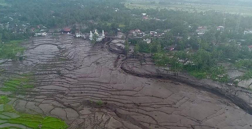
  • ‘Cold Lava’ Rivers flow in Philippines after Mount Canlaon eruption

    Why in the News?

    • After Mount Canlaon erupted in the Philippines, cold lava started flowing through streets and rivers.
      • It was followed by ashfall, and dangers like floods and mudflows downstream.

    What is Cold Lava?

    • Cold lava, also known as “lahar,” is a mixture of water and rock fragments that flows rapidly down the slopes of a volcano, often triggered by heavy rainfall or volcanic eruptions.
    • The mixture forms a concrete-like substance that destroys everything in its path.
    • This can also include smooth, glassy textures or rough and jagged textures.

    Another example of cold Lava in the world

    • Mount Merapi, Indonesia (2023): An eruption of Mount Merapi resulted in the deaths of at least 23 climbers and spewed ash up to 3,000 meters into the air, covering towns and villages

    How harmful is Cold Lava?

    • Rain can carry cold lava down the slopes of a volcano during an eruption and into the path of nearby towns or villages.
    • According to the United States Geological Survey, cold lava has the power to crush and bury things in its path.
    • It also moves quickly like wet concrete and is considered more destructive than hot lava.

    About Mount Canlaon

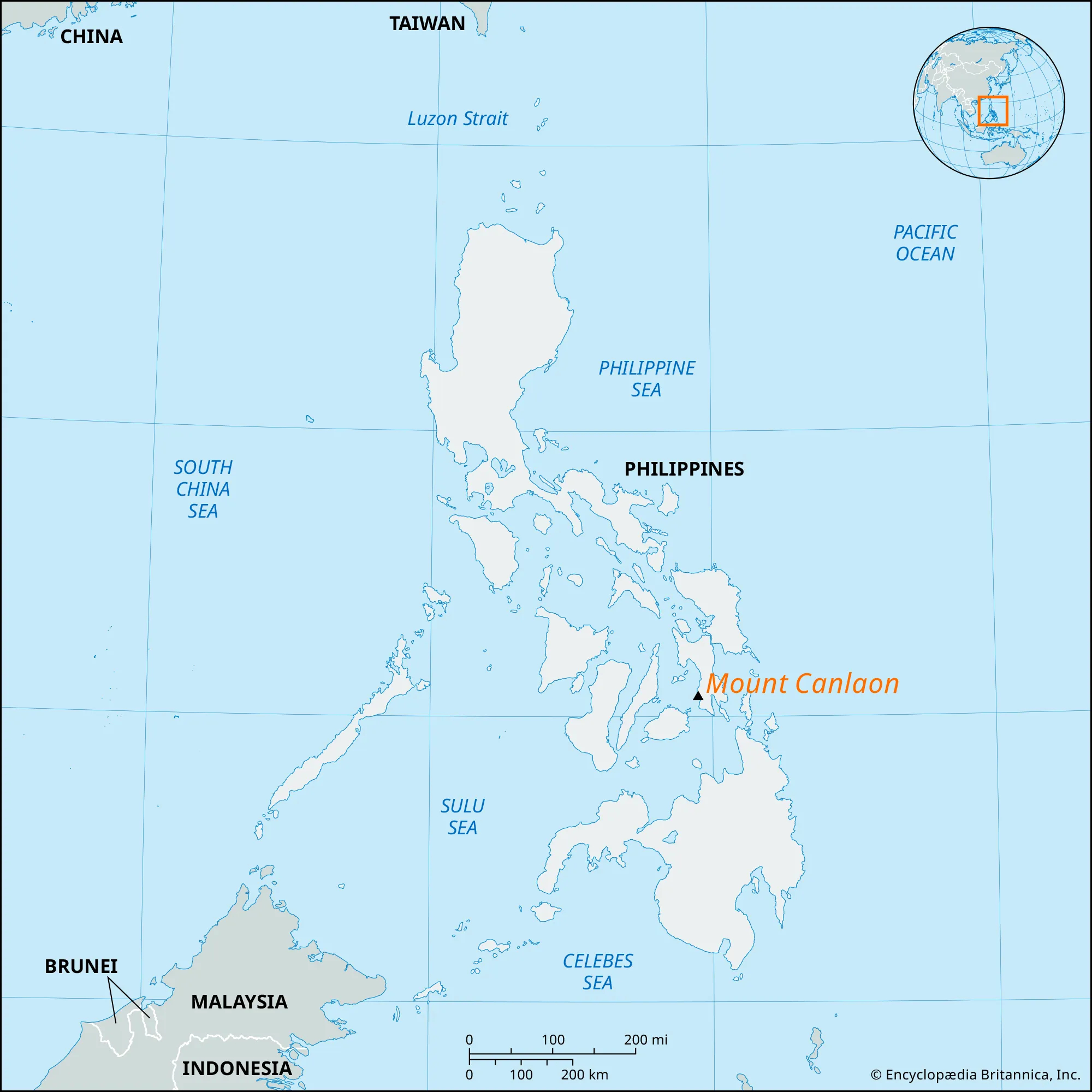
    • Mount Canlaon, located in the Philippines, is an active stratovolcano known for its frequent eruptions and volcanic activity.
    • It is situated on the island of Negros in the Visayas region of the Philippines.
    • It is part of the Pacific Ring of Fire, known for its high volcanic activity.
    • It poses hazards such as ash fall, lava flows, pyroclastic flows, and lahars (mudflows) that can endanger nearby communities and agriculture.


    PYQ:

    [2021] Discuss about the vulnerability of India to earthquake-related hazards. Give examples including the salient features of major disasters caused by earthquakes in different parts of India during the last three decades.

  • What is happening in the French territory of New Caledonia?

    Why in the News?

    New Caledonia, France’s Pacific island territory, is under a state of emergency due to deadly riots.

    About New Caledonia 

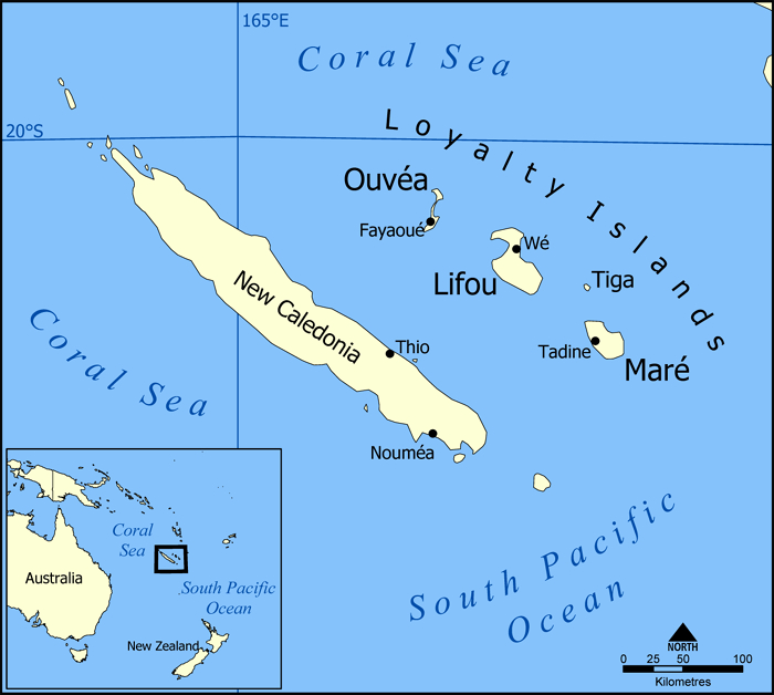
    • New Caledonia is a French overseas territory in the Pacific.
    • It enjoys a large degree of autonomy but depends heavily on France for matters like defence and education.
    • It includes the island of New Caledonia where the capital, Noumea, is located, the Loyalty Islands; the Belep Islands; and the Ile des Pins.
    • New Caledonia’s lagoons were designated a UNESCO World Heritage site in 2008.

    The Crisis: A Quick Recap

    • New Law: The French government passed a law that has upset people in New Caledonia.
    • Vote Reforms: Now, French citizens who lived on the island for 10 years or more can vote. The government says it’s fairer this way.
    • Resistance from Indigenous people: The locals, especially the Kanak community, feel this gives too much power to French settlers and stops them from gaining independence.

    How did France occupy this territory? 

    • Exploration: British explorer James Cook named the island New Caledonia in 1774 after the Latin name for Scotland.
    • French Annexation: France annexed it in 1853 and New Caledonia became a French overseas territory in 1946.
    • Fewer Locals: France brought in lots of French people. Now, the original Kanak people are only 40% of the population, while others, like the Caldoches and newer French arrivals, make up the rest.

    Why are the people protesting?

    • There were similar fights in the 1990s, leading to promises of more power for locals.
    • In 2018, 2020, and 2021, they voted on whether to be independent from France. But many boycotted the last vote, saying it wasn’t fair because of the pandemic.

    Why is it significant for France?

    • France sees New Caledonia as important for keeping power in the region.
    • It wants to stay strong in the Pacific to stand up to other big powers, like China.

    PYQ:

    [2014] Explain how the foundations of the modern world were laid by the American and French revolutions.

  • In news: Volkhov River

    Why in the News?

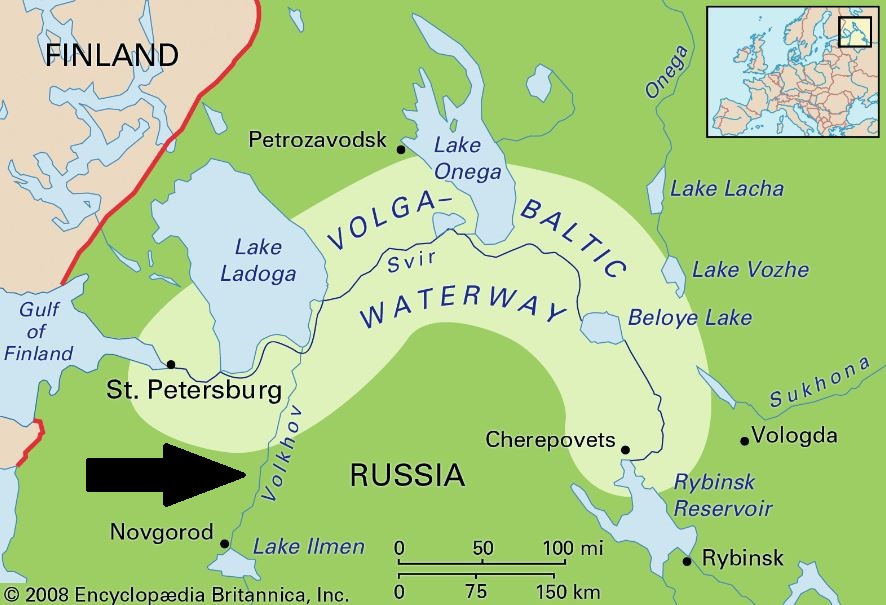
    Four medical students from India studying in a university in Russia drowned in Volkhov River near St. Petersburg.

    About Volkhov River

    • The Volkhov River is a significant waterway in northwestern Russia.
    • It is located in the Leningrad Oblast and Novgorod Oblast of Russia, in the northwestern part of the country.
    • It stretches approximately 224 kilometers (139 miles) from Lake Ilmen to Lake Ladoga.
    • Origin: It flows out of Lake Ilmen north into Lake Ladoga, the largest lake in Europe.
    • Tributaries: The Msta River is the largest tributary of the Volkhov.
    • Major Cities: Several cities and settlements are situated along the banks of the Volkhov River, including Novgorod, Veliky Novgorod, and Volkhov.

    PYQ:

    [2020] Consider the following pairs:

    River – Flows into

    1. Mekong – Andaman sea
    2. Thames – Irish Sea
    3. Volga – Caspian Sea
    4. Zambezi – Indian Ocean

    Which of the pairs above is/are correctly matched?

    (a) Only 1

    (b) Only 2

    (c) 3 Only

    (d) None of the above/More than one of the above.

  • KAZA Summit 2024: Delegates renew calls to leave CITES

    Why in the news?

    At the KAZA 2024 Summit in Livingstone, Zambia, delegates reiterated the urge for member states to withdraw from CITES because they seek approval to trade their plentiful ivory and wildlife items.

    About the Convention on International Trade in Endangered Species of Wild Fauna and Flora (CITES):

    • It is an international agreement adopted in 1973 (entered into force in 1975) between governments.
    • Aim: To ensure that international trade in wild animals and plants does not threaten their survival.
    • Headquarters: Geneva, Switzerland.
    • Although CITES is legally binding on the Parties – in other words, they have to implement the Convention–it does not take the place of national laws.
    • Representatives of CITES nations meet every two to three years at a Conference of the Parties (COP) to review progress and adjust the lists of protected species, which are grouped into three categories with different levels of protection:
      • Appendix I: Includes the world’s most endangered plants and animals, such as tigers and gorillas. International commercial trade in these species, or even parts of them, is completely banned, except in rare cases such as scientific research.
      • Appendix II: Contains species like corals that are not yet threatened with extinction, but which could become threatened if unlimited trade were allowed. Also included are “look-alike” species that closely resemble those already on the list for conservation reasons. Plants and animals in this category can be traded internationally, but there are strict rules.
      • Appendix III: Species whose trade is only regulated within a specific country can be placed on Appendix III if that country requires cooperation from other nations to help prevent exploitation.

    What is Kavango-Zambezi Trans-Frontier Conservation Area (KAZA-TFCA)?

    • The Kavango-Zambezi Trans-Frontier Conservation Area (KAZA-TFCA) spans 520,000 square kilometers. It covers parts of five southern African nations. These nations are Angola, Botswana, Namibia, Zambia, and Zimbabwe.
    • The area is centered around the Okavango and Zambezi river basins. The combined elephant population in these nations represents over two-thirds of Africa’s total, estimated at around 450,000.
    • Botswana has the largest elephant population within the region, with 132,000 elephants. Zimbabwe follows with 100,000 elephants.

    Key Objectives of KAZA 2024 Summit :

    • Conservation: Promote the sustainable management and conservation of wildlife across the five member states: Angola, Botswana, Namibia, Zambia, and Zimbabwe.
    • Economic Benefit: To explore ways to monetize abundant wildlife resources, particularly elephants, to fund conservation efforts and benefit local economies.

    Dominant Issues:

    • At the 19th meeting of the CITES conference in Panama in 2022, KAZA states and five other southern African countries advocated for opening up trade in ivory and elephant products.
    • Southern African countries, including those in the KAZA region, argue that their large elephant populations contribute to habitat loss and human-wildlife conflict.
    • Despite repeated requests, CITES delegates rejected the proposal, leading to frustration among African countries.
    • Ten countries, including KAZA states and others like Eswatini, Lesotho, Mozambique, South Africa, and Tanzania, declared a dispute with CITES. They criticized CITES for straying from its founding principles and adopting ideologies over science-based conservation strategies.

    Way forward:

    • Lobbying for Change: Advocacy for a more equitable and science-based approach to wildlife trade regulations within international frameworks like CITES.
    • Regional Cooperation: Enhance collaboration among member states to develop joint conservation strategies and share best practices for managing human-wildlife conflicts.
    • Diversification of Revenue Streams: Explore alternative sources of funding for conservation efforts, such as ecotourism, carbon credits, and sustainable agriculture.

    Mains PYQ:

    Q How does biodiversity vary in India? How is the Biological Diversity Act, 2002 helpful in the conservation of flora and fauna? (250 Words, 15 Marks) (UPSC IAS/2018)

  • In news: Campi Flegrei Super Volcano 

    Why in the News?

    A 4.4 magnitude earthquake struck Italy’s Campi Flegrei super volcano, with Pozzuoli as the epicentre. Felt as far as Naples, it’s the strongest tremor in 40 years

    Bradyseism Concerns near Campi Flegrei:

    • Campi Flegrei is prone to bradyseism, where ground elevation changes due to subsurface pressure.
    • The area, located 50 kilometres from Mt. Vesuvius, is undergoing a new cycle of bradyseism, according to volcanologists.
    • Over 500,000 people reside in the red zone adjacent to Campi Flegrei, prompting the Italian Civil Protection Agency to update evacuation plans.

    About Campi Flegrei Volcano

    • Campi Flegrei, also known as the Phlegraean Fields, is a large volcanic area located in the western suburbs of Naples, Italy.
    • It is one of the most active volcanic systems in the world and has been active for at least 50,000 years.

    Its Volcanic System:

    • Location: Campi Flegrei is situated within the Campanian volcanic arc in southern Italy, extending from the city of Naples to the Gulf of Pozzuoli.
    • Geological Formation: The volcanic system of Campi Flegrei is characterized by a large caldera, which is a collapsed volcanic crater, surrounded by numerous volcanic vents, craters, and lava domes. The caldera has a diameter of about 13 kilometers (8 miles).
    • Volcanic Activity: Campi Flegrei is considered a supervolcano due to its size and potential for large eruptions. It has experienced numerous periods of volcanic activity throughout its history, including explosive eruptions, lava flows, and phreatic (steam-driven) eruptions.
    • Terrain Features: The landscape of Campi Flegrei is characterized by volcanic features such as craters, fumaroles (steam vents), mud pots, and hot springs.

    PYQ:

    [2021] Mention the global occurrence of volcanic eruptions in ‘2021’ and their impact on regional environment.

    [2018] Consider the following statements:

    1. The Barren Island volcano is an active volcano located in the Indian Territory.
    2. Barren Island lies about 140 km east of Great Nicobar.
    3. The last time the Barren Island volcano erupted was in 1991 and it has remained inactive since then.

    Which of the statements given above is/are correct?

    (a) 1 only

    (b) 2 and 3

    (c) 3 only

    (d) 1 and 3

  • Orangutan uses Plant to treat wound

    Why in the news?

    An orangutan was observed treating a wound with medicine from a tropical plant, showcasing how some animals employ natural remedies to alleviate their ailments.

    • This behavior, documented in a recent study published in Scientific Reports, represents a novel instance of self-medication among wild animals.

    About Orangutans

    • Orangutans, are distinguished by their vivid red fur, are the largest arboreal mammals and spend the majority of their time in trees and forests.
    • The name “orangutan” translates to “man of the forest” in Malay.
    • They possess long, powerful arms and grasping hands and feet that facilitate movement through the branches.
    • Highly intelligent, these great apes share 96.4% of genetic makeup of modern man.
    • Orangutans primarily inhabit the tropical rainforests of Southeast Asia, specifically on the islands of Borneo and Sumatra.
    • Conservation Status: Critically Endangered (IUCN Red list)
    • Population: Bornean (Approximately 104,700); Sumatran (Approximately 13,846); Tapanuli (Around 800);
    • Behavioral Features:
      • These apes lead mostly solitary lives in the lowland forests, dining on wild fruits such as lychees, mangosteens, and figs, and drinking water collected in tree cavities.
      • Orangutans are mainly frugivorous, they primarily eat fruits, and consume leaves, bark, insects, and occasionally small animals.
      • They construct nests in trees with vegetation for sleeping at night and resting during the day.
      • And, now they are found treating a wound with medicine from a Tropical plant.

    PYQ:

    [2013] Consider the following:

    1. Star tortoise
    2. Monitor lizard
    3. Pygmy hog
    4. Spider monkey

    Which of the above are naturally found in India?

    (a) 1, 2 and 3 only

    (b) 2 and 3 only

    (c) 1 and 4 only

    (d) 1, 2 and 3 and 4

  • An overview of Sudan’s civil war 

    Why in the News? 

    The inability of successive governments to articulate a shared vision has resulted in the unfair distribution of wealth and resources in Sudan.

    ANKARA, TURKIYE – NOVEMBER 3: An infographic titled ”Sudanese civil war intensifies in the western cities” is created in Ankara, Turkiye on November 3, 2023. Since mid-April, the intensity of the conflicts between the army and the Rapid Support Forces (RSF) in Sudan, which have resulted in nearly 10,000 casualties, shifted from the capital Khartoum and its surroundings to the western cities. (Photo by Yasin Demirci/Anadolu via Getty Images)

    Historical background  of Conflict: 

    • In 1956: The government that came to power in 1956 emphasized an Arab and Islamic identity based on Mahdist principles. It was not representative of diverse communities and demanded compliance, leading to widespread resistance.
    • In 1989: In 1989, a new government seized control under the National Islamic Front, an alliance between army officers and the Muslim Brotherhood. Omar al-Bashir came to power, supported by Islamist leader Hassan al-Turabi, aiming to establish an Islamic state.
    • In 1991: The government set up an internal security apparatus, arresting and torturing dissenters. It introduced a new penal code in 1991 to impose an Islamization agenda.
    • In 2003: The al-Bashir (in 2003) regime enlisted Janjaweed militias to quell an insurgency in Darfur. These militias were later designated as the Rapid Support Forces in 2013.
    • In 2018-19: After protests in 2018 and al-Bashir’s removal in 2019, a transitional military government was established. Despite challenges and a failed coup attempt, a power-sharing agreement was reached, but another coup led by Abdel Fattah al-Burhan derailed the democratic transition.

    Causes of the present conflict in Sudan:

    • Deep-rooted Crisis in Governance: The conflict reflects a longstanding crisis within Sudan’s governing structure since gaining independence in 1956, characterized by power struggles and frequent coups.
    • Identity Crisis and Rebellion: Sudan has experienced numerous rebellions fueled by an identity crisis, with marginalized populations seeking autonomy and fair representation within the state.
    • Ethnic and Regional Disparities: Sudan comprises of 19 major ethnic groups and about 597 ethnic sub-groups. Since independence, the Sudanese have experienced 35 coups and attempted coups, more than any other African country.
    • Religious and Political Ideologies: Shifts in government ideologies, such as the establishment of an Islamic state in 1989, have exacerbated tensions and led to further marginalization of certain groups.
    • Role of Militias: The emergence of paramilitary forces, such as the Rapid Support Forces, has complicated the conflict dynamics, with militias vying for power and control over resources.
    • Other country’s involvement: External influences, including support from foreign entities like Russia, have played a role in shaping the conflict landscape, particularly in resource-rich regions like Darfur.
    • Economic Interests: Economic factors, such as control over lucrative industries like gold mining, have contributed to the entrenchment of certain groups in power and fueled conflict dynamics.

    Way Forward:

    • Establish a Civilian-Led Government: Sudan needs to prioritize the establishment of a transparent, civilian-led government that represents the diverse Sudanese populace. This government should ensure inclusivity and participation in decision-making processes.
    • Disarm and Demobilize Militias: Urgent action is needed to disarm and demobilize militias like the Rapid Support Forces. This will prevent militia dominance over the state and reduce the risk of armed confrontations and conflicts.
    • International Support for Reconstruction: Sudan requires collaborative efforts from the international community to aid in post-conflict reconstruction. This support can include financial assistance, capacity-building programs, and technical expertise to rebuild infrastructure, institutions, and communities affected by conflict.

    Mains PYQ 

    Q Africa was chopped into states artificially created by accident of European competition. Analyse. (UPSC IAS/2013)

  • Mapping: Hopen Island in the Svalbard Archipelago

    Why in the news?

    Researchers disclosed that one of Norway’s Hopen Island in the Svalbard Archipelago witnessed its first walrus death due to Bird Flu (H5N1).

    About Hopen Island in the Svalbard Archipelago

    • Hopen Island is situated in the southern part of the Svalbard Archipelago, between the Barents Sea and the Greenland Sea.
    • The island covers an area of about 47 square km, making it one of the smaller islands in the Svalbard group.
    • The landscape mainly consists of low-lying tundra, rocky outcrops, and coastal cliffs.
    • Like the rest of Svalbard, Hopen Island experiences a harsh Arctic climate. Winters are long, dark, and extremely cold, while summers are short and cool.
    • It serves as an important breeding ground for seabirds such as guillemots, puffins, and kittiwakes. Polar bears are also occasionally spotted on the island, along with walruses, seals, and Arctic foxes.
    • It is uninhabited and largely inaccessible to humans due to its remote location and extreme weather conditions.
    • Historically, Hopen Island has been of strategic importance due to its location between the Barents Sea and the Greenland Sea.

    H5N1 Bird Flu: Details

    • H5N1 originated from a virus outbreak on a goose farm in China in 1996 and has since evolved into a highly pathogenic strain.
    • The virus quickly spread from Europe to Africa, Asia, North America, and South America, and most recently, it reached mainland Antarctica.
    • H5N1 is a subtype of the influenza A virus that causes severe respiratory disease in birds, known as avian influenza or “bird flu”.
    • Influenza A viruses are classified by subtypes based on the properties of their surface proteins, with H5N1 being one subtype.

    How widespread is it?

    • The virus has affected birds in over 80 countries, resulting in mass culling of poultry and wild birds.
    • Furthermore, it has now begun infecting mammals, including seals, sea lions, and marine mammals.
    • While humans rarely contract bird flu, those at risk are typically individuals who have extensive contact with infected birds at poultry farms.
    • Bird flu first broke out in Maharashtra in 2006.
    • The H5N1 virus led to the culling of millions of poultry so as to contain the virus. But it has resurfaced from time to time.


    PYQ:

    [2014] Which one of the following pairs of islands is separated from each other by the ‘Ten Degree Channel’?

    (a) Andaman and Nicobar

    (b) Nicobar and Sumatra

    (c) Maldives and Lakshadweep

    (d) Sumatra and Java

  • [PREMIUM] To the South Pole – Antarctica

    Why in the news?

    The Antarctic Treaty has sparked debates among policymakers, scientists, and the public, as they weigh the balance between environmental conservation, economic interests, and geopolitical concerns in Antarctica.

    About Antarctica

      • Antarctica is the fifth-largest continent, covering an area of approximately 14 million square km.
      • It is situated entirely within the Antarctic Circle, with its geographic center near the South Pole.
      • It is the coldest, driest, and windiest continent on Earth.
      • The interior of Antarctica is a polar desert, receiving very little precipitation, mostly in the form of snow.
    • The Antarctic Ice Sheet is the largest single mass of ice on Earth, containing approximately 70% of the world’s freshwater.

    Geographical Features:

    Description
    Mountains
    • The continent is home to several mountain ranges, including the Transantarctic Mountains.
    • Vinson Massif is the highest peak at 4,892 meters (16,050 feet) above sea level.
    Ice Shelves Large floating ice shelves extend along the coast, formed by glaciers flowing from the interior, crucial for stabilizing the Antarctic ice sheet.
    Glaciers Numerous glaciers flow from the high interior to the coast, including Pine Island Glacier and Thwaites Glacier, among the largest and fastest-moving in the world.
    Icebergs
    • Glaciers calve off large chunks of ice, forming icebergs of various sizes.
    • Antarctic Iceberg A-68, which broke off from the Larsen C Ice Shelf in 2017, was one of the largest recorded.
    Plateaus Much of Antarctica’s interior consists of high, flat plateaus covered by ice, reaching elevations over 4,000 meters (13,000 feet) above sea level.
    Ice-Free Areas Despite being predominantly ice-covered, some ice-free areas exist along the coastlines and in the Antarctic Peninsula region, supporting limited vegetation and wildlife.

    Territorial Claims on Antarctica:

    The countries with territorial claims in Antarctica are:

    1. Argentina: Claims a sector of Antarctica known as Argentine Antarctica.
    2. Australia: Claims the Australian Antarctic Territory.
    3. Chile: Claims a sector of Antarctica known as Chilean Antarctic Territory.
    4. France: Claims a sector of Antarctica known as Adélie Land.
    5. New Zealand: Claims the Ross Dependency.
    6. Norway: Claims a sector of Antarctica known as Queen Maud Land.
    7. United Kingdom: Claims a sector of Antarctica known as the British Antarctic Territory.
    8. United States: Claims a sector of Antarctica known as the Marie Byrd Land.

    India’s Antarctic Outreach

    • Initiated in 1981, India’s Antarctic Program, managed by National Centre for Polar and Ocean Research, encompasses multi-disciplinary research expeditions.
    • With the establishment of research bases like Dakshin Gangotri (1983) (now decommissioned), Maitri (1989), and Bharati (2012), India contributes significantly to Antarctic exploration.
    • Notably, India’s presence in Antarctica includes a Post Office established in 1984, facilitating communication and research logistics.


    PYQ:

    [2011] The formation of ozone hole in the Antarctic region has been a cause of concern. What could be the reason for the formation of this hole?

    (a) Presence of prominent tropospheric turbulence; and inflow of chlorofluorocarbons

    (b) Presence of prominent polar front and stratospheric’: Clouds; and inflow of chlorofluorocarbons

    (c) Absence of polar front and stratospheric clouds; and inflow of methane and chlorofluorocarbons

    (d) Increased temperature at polar region due to global warming.

  • [PREMIUM] Conflict Regions in West Asia

    Why in the news?

    • The resurgence of West Asian rivalries has been reignited by the ongoing Hamas-Israel War, which commenced on October 7, 2023.
    • With a backdrop of historical conflicts, including the Iran-Iraq War and Israel’s engagements with Hezbollah and Hamas, the current conflict is escalating tensions in the region.

    About West Asia

    [A] Political Overview:

    1. Countries:
    • West Asia comprises 17 countries, including:
      • In Gulf Cooperation Council (GCC) has 6 countries such as Saudi Arabia, UAE, Qatar, Bahrain, Kuwait, and Oman.
      • Middle Eastern countries like Iran, Iraq, Turkey, Syria, Lebanon, Jordan, Israel, Palestine, and Yemen.
      • Egypt is sometimes included in the definition of West Asia due to its geographical proximity and historical ties.
    1. Geopolitical Dynamics:
      • The region is characterized by complex geopolitical dynamics, including conflicts, alliances, and power struggles.
      • Ongoing conflicts include the Syrian Civil War, the Israeli-Palestinian conflict, and the Yemeni Civil War, among others.
      • Strategic interests of global powers, including the United States, Russia, and China, contribute to the region’s instability.

    [B] Physical Features:

    1. Terrain:
      • West Asia encompasses varied terrain, including vast deserts like the Rub’ al Khali in Saudi Arabia and the Syrian Desert in Syria and Jordan.
      • Mountainous regions include the Zagros Mountains in Iran, the Taurus Mountains in Turkey, and the Anti-Lebanon Mountains along the Lebanon-Syria border.
      • Fertile river valleys, such as the Tigris-Euphrates in Iraq and the Nile in Egypt, have historically supported agriculture and civilization.
    2. Climate:
      • The region experiences diverse climates:
        • Arid and semi-arid climates prevail in much of the interior, with hot summers and mild winters.
        • Mediterranean climates along the coastal areas, characterized by hot, dry summers and mild, wet winters.
        • Highland climates in mountainous regions, with cooler temperatures and higher precipitation.
    3. Natural Resources:
      • West Asia is endowed with abundant natural resources, notably oil and natural gas reserves, concentrated primarily in countries like Saudi Arabia, Iran, Iraq, and the Gulf states.
      • The region also possesses significant mineral deposits, including phosphates in Jordan, sulfur in Iraq, and metals like copper and iron in various countries.

    [C] Physiographical Details:

    1. Biodiversity:
      • Despite its predominantly arid climate, West Asia supports diverse ecosystems, including desert, mountain, and coastal habitats.
      • Unique species of flora and fauna, adapted to harsh environmental conditions, inhabit the region, including desert mammals like the Arabian oryx and mountain species like the Persian leopard.
    2. Water Resources:
      • Water scarcity is a pressing issue in West Asia, exacerbated by population growth, urbanization, and climate change.
      • Countries rely on shared river basins, such as the Tigris-Euphrates and the Nile, leading to water disputes and conflicts.
      • Desalination plants along the coastlines provide an alternative source of freshwater, particularly in Gulf countries.
    3. Human Geography:
      • The region is home to diverse ethnic and religious communities, including Arabs, Kurds, Turks, Persians, Jews, and Christians, among others.
      • Urbanization is on the rise, with major cities like Riyadh, Tehran, Istanbul, and Cairo serving as economic, cultural, and political centers.

    Flash Points in West Asia

    Conflict 

    Areas

    Description Flashpoints
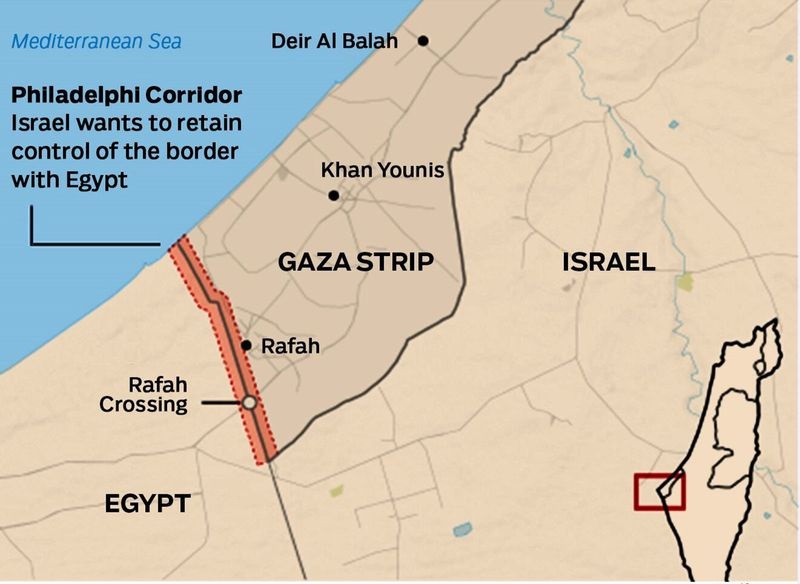
    Israeli-Palestinian Conflict A protracted dispute over territory, borders, and self-determination between Israel and Palestinians. Gaza Strip: A densely populated coastal enclave with sandy beaches, urban areas, and limited agricultural land. It is approximately 41 kilometers long and 6 kilometers wide.


    Netzarim Corridor: The Netzarim Corridor is a just under seven-kilometer-long corridor that is set to cut Gaza City from the rest of the enclave, running east to west from the Israeli border south of Nahal Oz to the Mediterranean Sea. Israel has previously bisected the Gaza Strip to create a Buffer Zone.

    West Bank: Diverse geography including mountainous terrain, fertile valleys, and the Jordan River Valley. It covers an area of approximately 5,655 square kilometers.

    East Jerusalem: Hilly terrain with historic landmarks and religious sites, including the Old City with its ancient walls, mosques, and churches.

    Syrian Civil War Complex conflict involving multiple factions, resulting in immense humanitarian suffering. Aleppo: Surrounded by fertile plains and agricultural land, it is one of the oldest continuously inhabited cities in the world. It covers an area of approximately 190 square kilometers.

    Damascus: Situated in the foothills of the Anti-Lebanon Mountains, it is one of the oldest cities in the Middle East. It spans an area of around 105 square kilometers.

    Homs: Located along the Orontes River, it is an important industrial center with a history dating back to ancient times. It has an area of about 165 square kilometers.

    Idlib: Mix of agricultural plains, hills, and urban centers, covering an area of approximately 6,097 square kilometers.

    Iraqi Conflict Various conflicts including the Iraq War, sectarian violence, insurgency, and fight against ISIS. Baghdad: Flat terrain surrounded by fertile agricultural land, situated on the Tigris River. It covers an area of around 204 square kilometers.

    Mosul: Surrounded by plains, historic landmarks, and the Tigris River, it is one of Iraq’s largest cities. It spans an area of approximately 370 square kilometers.

    Fallujah: In the Euphrates River valley with arid landscapes and urban areas, it is strategically located near major highways. It covers an area of about 139 square kilometers.

    Kirkuk: Oil-rich region with diverse ethnic populations and mountainous terrain, it covers an area of approximately 9,679 square kilometers.

    Yemeni Civil War Involves the Yemeni government, Houthi rebels, and other factions, leading to a dire humanitarian crisis. Sana’a: Surrounded by mountains and valleys in the Yemeni Highlands, it is one of the highest capital cities in the world. It covers an area of approximately 73 square kilometers.

    Aden: Coastal city with a strategic port and urban areas, located on the Gulf of Aden. It spans an area of around 50 square kilometers.

    Hodeidah: Major port city with coastal plains, mountains, and urban areas, situated on the Red Sea coast. It covers an area of about 192 square kilometers.

    Lebanese-Israeli Tensions Sporadic clashes and occasional escalation over territorial disputes and Hezbollah’s presence. Southern Lebanon: Rugged terrain with mountains, fertile valleys, and coastal plains along the Mediterranean Sea. It covers an area of approximately 929 square kilometers.
    Kurdish-Turkish Conflict Involves the Turkish government and Kurdish separatist groups, focusing on Kurdish autonomy. Southeastern Turkey: Mountain ranges, plateaus, fertile river valleys, and urban areas, covering an area of approximately 190,534 square kilometers.

    Northern Iraq: Zagros Mountains, valleys, rivers, and urban centers, with an area of about 198,956 square kilometers.

    Iranian-Israeli Tensions Fueled by Iran’s support to militant groups and its nuclear program, leading to regional security concerns. Golan Heights: Plateau region with rocky slopes, volcanic hills, fertile agricultural land, and urban settlements. It spans an area of approximately 1,800 square kilometers.

    Southern Lebanon: Rugged terrain with valleys, plains, and urban areas, covering an area of about 929 square kilometers.

    Gulf States Tensions Rivalries among Gulf states are driven by ideological differences, political alliances, and economic interests. Qatar: Peninsula with desert terrain, low-lying coastal areas, and urban development, covering an area of approximately 11,586 square kilometers.

    Eastern Province of Saudi Arabia: Desert landscapes, oasis areas, oil fields, and urban centers, with an area of about 672,522 square kilometers.


    PYQ:

    [2015] Which one of the following countries of South-West Asia does not open out to the Mediterranean Sea?

    (a) Syria

    (b) Jordan

    (c) Lebanon

    (d) Israel