💥Join UPSC 2027,2028 Mentorship (July Batch) + XFactor Notes & Microthemes PDF

GS Paper: GS1-14.Important Geophysical phenomena such as earthquakes, Tsunami, Volcanic activity, cyclone etc.,

  • What are Flying Rivers/ Atmospheric Rivers?

    Why in the News?

    Droughts and fires in South America highlight the importance of “flying rivers” — rain-bearing vapor streams disrupted by Amazon deforestation.

    What are Atmospheric Rivers?

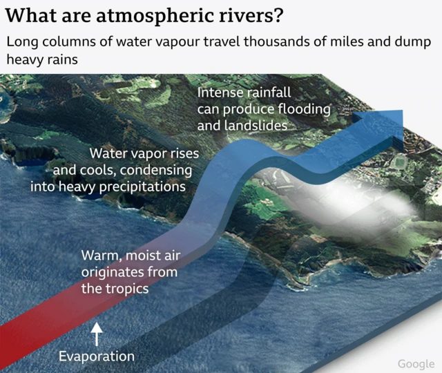
    • Overview: Long, narrow bands of concentrated water vapour in the lower atmosphere, often termed “rivers in the sky.”
    • Dimensions: Typically 2,000–5,000 km long, 400–500 km wide, and about 3 km deep.
    • Water Transport: Carry nearly 90% of water vapour across Earth’s mid-latitudes — almost double the Amazon River’s flow.
    • Formation: Warm tropical seawater evaporates, and winds transport this moisture; upon encountering land or mountains, vapour condenses into heavy rainfall or snow.
    • Role: Unlike short-term weather systems, Atmospheric Rivers (ARs) shape long-term hydrological cycles and trigger extreme precipitation events.

    Global Impacts of Atmospheric Rivers:

    • Flooding & Extreme Weather: Cause 80% of flood-related damages along the US West Coast; also linked to devastating floods in Europe, Africa, South America, and Australia.
    • South America: Amazon’s “flying rivers” disrupted by deforestation, leading to droughts in Peru, Bolivia, and Ecuador; threatens Amazon rainforest’s survival and risks savannisation.
    • East Asia: Up to 80% of heavy rainfall events in China, Korea, and Japan during early monsoon linked to ARs.
    • Climate Connection: Warming oceans are making ARs longer, wider, and more intense, increasing risks of catastrophic floods and landslides.
    • Positive Role: Contribute 30–50% of annual precipitation in some regions (e.g., US West Coast) and help end 33–74% of droughts.

    Atmospheric Rivers in India’s Context:

    • Interaction: ARs combine with cyclonic circulations and the Himalayan ranges, causing extreme rainfall and flash floods.
    • Case Studies:
      • 2010 Leh cloudburst (Ladakh) – flash floods and mudslides.
      • 2011 Kupwara floods (J&K) – severe AR-driven rainfall.
    • Study (1951–2020): Identified 574 AR events during the monsoon season in India.
    • Recent Trends: Nearly 80% of India’s most severe floods (1985–2020) linked to AR activity.
    • Cause: Rapid Indian Ocean warming intensifies evaporation, moisture transport, and AR-driven floods.
    • Impact: Leads to short, intense rainfall spells, landslides, flash floods, crop loss, and mass displacement of communities.
    [UPSC 2024] With reference to “water vapour,” which of the following statements is/are correct?

    1. It is a gas, the amount of which decreases with altitude.

    2. Its percentage is maximum at the poles.

    Select the answer using the code given below:

    Options: (a) 1 only* (b) 2 only (c) Both 1 and 2 (d) Neither 1 and 2


  • South-west Monsoon: Its Onset and Retreat

    Why in the News?

    According to the India Meteorological Department (IMD), the southwest monsoon began its earliest withdrawal in a decade on September 14 from western Rajasthan, three days before the usual date of September 17.

    What is Monsoon? 

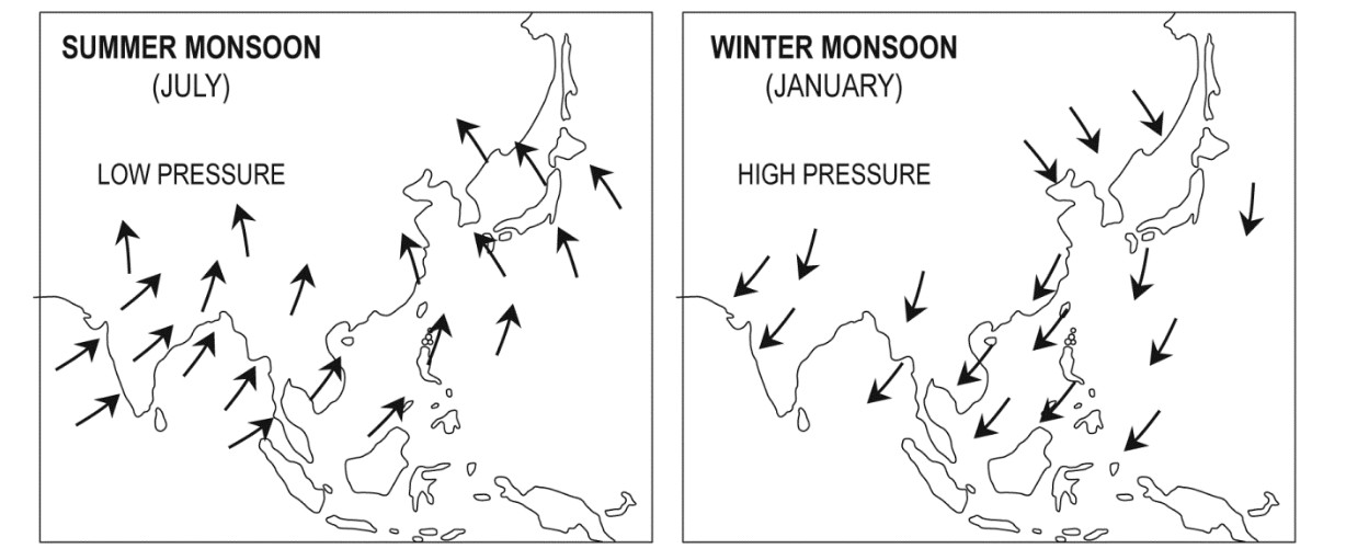
    • Overview: A seasonal reversal of winds, southwest winds (wet) in summer and northeast winds (dry) in winter.
    • Onset Date: Officially begins June 1 over Kerala, advances northwards, covering entire India by mid-July.
    • Importance: Accounts for ~75% of India’s annual rainfall, critical for Kharif crops, water storage, and ecosystems.

    Mechanism of Monsoon Onset:

    • Differential Heating: Indian landmass heats faster than the Indian Ocean, creating low pressure over NW India that pulls in moist winds.
    • Mascarene Highs:
      • Located near Mascarene Islands (east of Madagascar).
      • Strengthen during May–June winter in Southern Hemisphere.
      • Push strong cross-equatorial winds from the SE Indian Ocean towards India.
    • Cross-Equatorial Flow:
      • Southeast trades from Mascarene High cross the equator.
      • Deflected by Coriolis, they become southwest monsoon winds, feeding both Arabian Sea branch and Bay of Bengal branch.
    • ITCZ (Intertropical Convergence Zone) Shift: Moves northwards over Ganga plains, anchoring the monsoon trough.
    • Tibetan Plateau Heating: Acts as an elevated heat source, deepening low pressure.
    • Jet Stream Influence:
      • Subtropical Westerly Jet (STWJ) shifts north of Himalayas, allowing the monsoon trough.
      • Tropical Easterly Jet (TEJ) develops, enhancing moisture flow.
    • Local Triggers: Orographic uplift along Western Ghats, NE Hills, and Indo-Gangetic plains causes heavy rains.

    What is Retreat/Withdrawal of Monsoon?

    • Earliest Withdrawal (2025): Began Sept 14 from western Rajasthan — earliest in a decade (normal = Sept 17).
    • Withdrawal Process: Gradual, completes by mid-October.
    • IMD Withdrawal Criteria:
      1. Development of anti-cyclonic circulation at lower troposphere.
      2. No rainfall for 5 consecutive days over the region.
      3. Prevalence of dry weather conditions.
    • Seasonal Marker: IMD fixes Sept 30 as the official end of SW monsoon.
    • Agricultural Role: Retreat moisture crucial for Rabi crop sowing.

    Influencing Factors for Monsoon Retreat:

    • Seasonal Cooling: Reduced solar heating over land in September weakens low pressure.
    • Pressure Gradient Reversal: High pressure redevelops over NW India, collapsing SW winds.
    • ITCZ Shift: Moves back southwards towards the equator, reversing wind patterns.
    • Jet Stream Role: TEJ weakens, westerlies return, pushing out moist winds.
    • Topography & Seas: Coastal and mountainous regions (e.g., SE peninsula, Bay of Bengal) may still receive residual/post-monsoon showers.
    • Mascarene Highs: As SH winter ends, Mascarene highs weaken, cross-equatorial inflow diminishes, aiding withdrawal.

    Climatic Phenomena affecting the Indian Monsoon:

    1. ENSO (El Niño–Southern Oscillation):

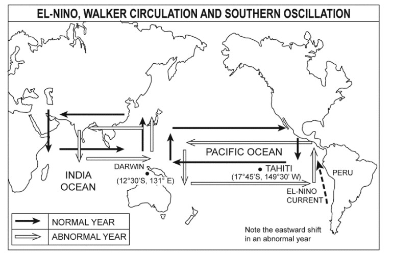
    • ENSO originates in the equatorial Pacific Ocean and strongly influences the Pacific Walker Circulation (PWC).
      1. El Niño years: The eastern and central Pacific waters warm up. This weakens the Walker circulation and reduces the flow of moisture-laden winds from the Mascarene Highs towards India. As a result, the monsoon becomes weak or deficient, often leading to droughts.
      2. La Niña years: The opposite happens; Pacific waters cool, the Walker circulation strengthens, and strong cross-equatorial winds from the Mascarene Highs bring more moisture into India. Monsoon rainfall is usually above normal, sometimes leading to floods.
    • Key point: ENSO acts like a “remote controller” sitting in the Pacific but directly influencing the strength of the Indian monsoon winds.

    2. Indian Ocean Dipole (IOD):

    • The Indian Ocean itself has its own seesaw pattern of sea surface temperatures.
      • Positive IOD: Western Indian Ocean (near Africa) is warmer, and eastern Indian Ocean (near Indonesia) is cooler. This strengthens cross-equatorial winds from the Mascarene Highs, feeding more moisture into India. Result: Good rainfall, strong monsoon, even if El Niño is present.
      • Negative IOD: Western Indian Ocean is cooler, eastern side is warmer. This pulls away monsoon winds from India and weakens the rainfall.
    • Key point: IOD is a “local driver” sitting in the Indian Ocean, which can either amplify or cancel out ENSO’s effect.

    3. ENSO–IOD Interaction:

    • Monsoon outcome is not decided by ENSO or IOD alone, but by how they combine:
      • El Niño + Positive IOD: IOD can cancel El Niño’s bad effect (1997 monsoon was near normal).
      • El Niño + Negative IOD: Worst-case combo, often brings severe droughts.
      • La Niña + Positive IOD: Both reinforce each other, leading to very heavy rainfall and flood risk.
      • ENSO Neutral + Positive/Negative IOD: IOD becomes the deciding factor.

    The Big Picture:

    • Pacific Walker Circulation is the “conveyor belt” moving rising and sinking air across the Pacific and Indian Oceans.
      • When it shifts east (El Niño): India gets less rain.
      • When it strengthens west (La Niña): India gets more rain.
    • IOD modifies this system locally in the Indian Ocean-  it can either buffer or worsen ENSO’s impact.
    • The Mascarene Highs act as the main “engine room” for cross-equatorial winds, but the Walker circulation and IOD decide how strong that engine runs.
    • Madden–Julian Oscillation (MJO): An eastward-moving pulse of cloud and rainfall that travels around the equator every 30–60 days.
      • MJO decides the intra-seasonal variability: when it rains heavily (active phase) and when dry breaks occur.


    [UPSC 2012] Consider the following statements:

    1. The duration of the monsoon decreases from southern India to northern India.

    2. The amount of annual rainfall in the northern plains of India decreases from east to west.

    Which of the statements given above is/are correct?

    Options: (a) 1 Only (b) 2 Only (c) Both 1 and 2* (d) Neither 1 nor 2


    [UPSC 2017] With reference to ‘Indian Ocean Dipole (IOD)’ sometimes mentioned in the news while forecasting Indian monsoon, which of the following statements is/are correct?

    1. The IOD phenomenon is characterized by a difference in sea surface temperature between tropical Western Indian Ocean and tropical Eastern Pacific Ocean.

    2. An IOD phenomenon can influence an El Nino’s impact on the monsoon.

    Select the correct answer using the code given below:

    (a) 1 only  (b) 2 only * (c) Both 1 and 2  (d) Neither 1 nor 2


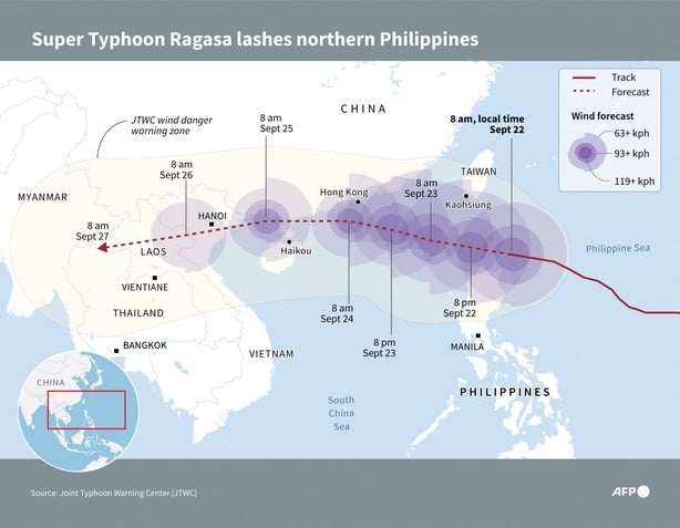
  • Super Typhoon Ragasa

    Why in the News?

    China is planning to evacuate 4 lakh people ahead of the landfall of Super Typhoon Ragasa.

    Super Typhoon Ragasa

    About Typhoon & Super Typhoon:

    • Typhoon: A tropical cyclone forming in the Western Pacific Ocean and China Sea, usually above sea temperatures of 27°C.
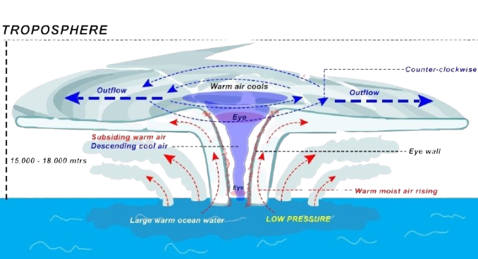
    • Formation: Warm, moist air rises and creates a low-pressure system with spiralling winds.
    • Super Typhoon: Defined by the US Joint Typhoon Warning Center (JTWC) as sustained winds of ≥240 km/h (some agencies use 185 km/h).
    • Structure:
      • Eye: Calm centre.
      • Eyewall:  Strongest winds and rainfall.
      • Spiral Rainbands: Bands of showers spreading outward.
    • Impacts: Can cause storm surges, coastal flooding, landslides, and destruction of infrastructure, agriculture, and homes.

    Back2Basics: Tropical Cyclones

    • What is it: Large low-pressure systems over warm oceans, marked by rotating winds, heavy rain, and storm surges.
    • Conditions: Form when ocean temps >27°C, with moist rising air releasing latent heat to fuel convection.
    • Rotation: Driven by the Coriolis force – anticlockwise in Northern Hemisphere, clockwise in Southern.
    • Structure: Eye (calm), Eyewall (violent winds/rains), Rainbands (widespread showers).
    • Regional Names: Typhoons (Pacific), Hurricanes (Atlantic/Caribbean), Cyclones (Indian Ocean).
    • Drivers & Frequency: Common in Southeast Asia due to warm Pacific waters, El Niño/La Niña cycles, and climate change.
    • Impacts: Loss of life, property damage, flooding, soil salinisation, displacement, and disease outbreaks.
    • Climate Change Link: Global warming is making tropical cyclones stronger, less predictable, and more frequent, raising risks for coastal populations.


    [UPSC 2020] Consider the following statements:

    1. Jet streams occur in the Northern Hemisphere only.

    2. Only some cyclones develop an eye.

    3. The temperature inside the eye of a cyclone is nearly 10°C lesser than that of the surroundings.

    Which of the statements given above is/are correct?

    Options: (a) 1 only (b) 2 and 3 only (c) 2 only * (d) 1 and 3 only


  • Earth gains new tiny ‘Quasi-Moon’ 2025 PN7

    Earth gains new tiny 'Quasi-Moon' 2025 PN7

    Why in the News?

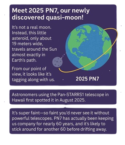
    Astronomers have confirmed the discovery of asteroid 2025 PN7, Earth’s latest quasi-moon.

    About Quasi-Moon 2025 PN7:

    • Discovery: First detected on 2 August 2025 by the Pan-STARRS 1 telescope in Hawaii; confirmed in September 2025 as Earth’s newest quasi-satellite.
    • Orbit: Circles the Sun, not Earth, but remains near Earth due to a 1:1 orbital resonance – meaning it completes one solar orbit in the same time as Earth.
    • Distance from Earth: At closest, ~299,000 km, similar to the Moon’s distance.
    • Physical Traits: Roughly 19 metres wide, very faint (magnitude 26.4), requiring large telescopes to track.
    • Orbital Parameters: Semi-major axis 1.003 AU (same as Earth), eccentricity 0.108 (slightly oval), inclination just under .
    • Arjuna Nature: Fits the Arjuna asteroid class criteria – extremely Earth-like orbit, low eccentricity, and low inclination, making it appear as a temporary companion.
    • Stability: Expected to remain a quasi-satellite for ~128 years before shifting into another orbital configuration.

    What is the Arjuna Asteroid Class?

    • Overview: A rare group of near-Earth objects (NEOs) with orbits closely matching Earth’s path around the Sun.
    • Etymology: Originated with the discovery of asteroid 1991 VG by astronomer Robert H. McNaught at the Siding Spring Observatory in Australia in 1991.
    • Name Origin: Inspired by Arjuna from the Mahabharata – symbolising fast-moving and elusive objects.
    • Special Traits:
      • Can approach Earth more closely than most asteroid families.
      • Sometimes become temporary mini-moons or quasi-satellites.
      • Have relatively low relative velocities, making them attractive for spacecraft missions.
    • Scientific Importance:
      • Offer natural laboratories for studying orbital resonance and gravitational effects.
      • Useful for testing asteroid mining and redirection technologies.
      • Significant for planetary defence, since tracking their movements refines collision risk predictions.
    [UPSC 2023] Consider the following pairs:

    Object in space – Description

    1. Cepheids – Giant clouds of dust and gas in space

    2. Nebulae – Stars which brighten and dim periodically

    3. Pulsars – Neutron stars that, are formed when massive stars run out of fuel and collapse

    How many of the above pairs are correctly matched?

    (a) Only one * (b) Only two (c) All three (d) None


  • Mount Etna Eruption

    Why in the News?

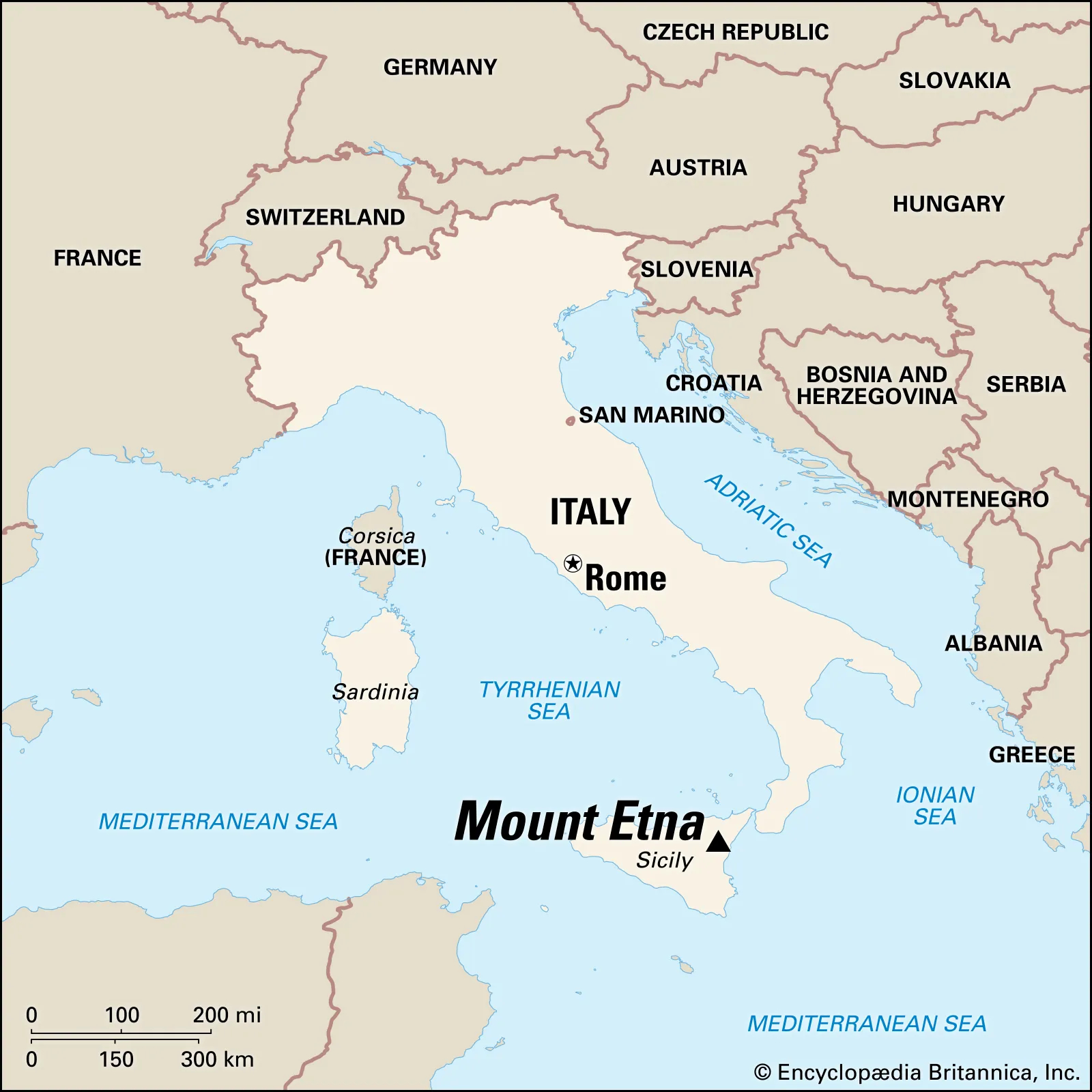
    Mount Etna has erupted again after its recent eruption in June.

    About Mount Etna:

    • Location: Situated on the east coast of Sicily, Italy, near the city of Catania.
    • Type: Mount Etna is a stratovolcano (also called a composite volcano), which is formed from layers of hardened lava, volcanic ash, and rocks.
    • Height: It stands at approximately 3,300 meters, making it the tallest volcano in Europe south of the Alps.
    • Recognition: Declared a UNESCO World Heritage Site in 2013, with documented volcanic activity for at least 2,700 years.
    • Eruption Record: Etna is almost constantly active. Notable eruptions have occurred in 1400 B.C., 1669, 2001, 2018, 2021, 2024, and 2025.
    • Volcanic Activity Style: Known for Strombolian and effusive eruptions, with occasional Plinian eruptions (rare and more explosive).

    Reasons Behind the Eruption:

    • Nature of Eruption: The eruption is classified as either Strombolian or possibly Plinian, depending on interpretation:
      • Strombolian Eruption: Characterized by moderate explosive bursts, caused by gas bubbles in magma suddenly bursting at the surface.
      • Plinian Eruption: Some volcanologists suggest this classification due to the large ash column that may have reached the stratosphere.
    • Eruption Trigger: The eruption likely began due to pressure buildup from gas within the magma chamber, leading to collapse of the southeast crater and lava flows.
    [UPSC 2014] Consider the following geological phenomena:

    1. Development of a fault

    2. Movement along a fault

    3. Impact produced by a volcanic eruption

    4. Folding of rocks Which of the above cause earthquakes?

    Options: (a) 1, 2 and 3 (b) 2 and 4 (c) 1, 3 and 4 (d) 1, 2, 3 and 4*


  • 1950 Assam Earthquake and Future Seismic Risks in the Himalayas

    Why in the News?

    75 years ago on August 15, 1950, a magnitude 8.6 earthquake — the strongest recorded on land — struck Northeast India and surrounding regions.

    1950 Assam Earthquake and Future Seismic Risks in the Himalayas

    About the Earthquake:

    • Magnitude: 8.6, the strongest recorded earthquake on land.
    • Impact Area: Tremors lasted 4–8 minutes, felt over 3 million sq. km in India, Myanmar, Bangladesh, Tibet, and South China.
    • Casualties: Over 1,500 deaths in India and 4,000+ in Tibet; heavy livestock losses and infrastructure destruction.
    • Secondary Disasters: Triggered landslides blocking rivers, followed by devastating flash floods.

    Geological and Tectonic Setting:

    • Epicentre: 40 km west of Rima (Zayu), near India–Tibet border in the Mishmi Hills.
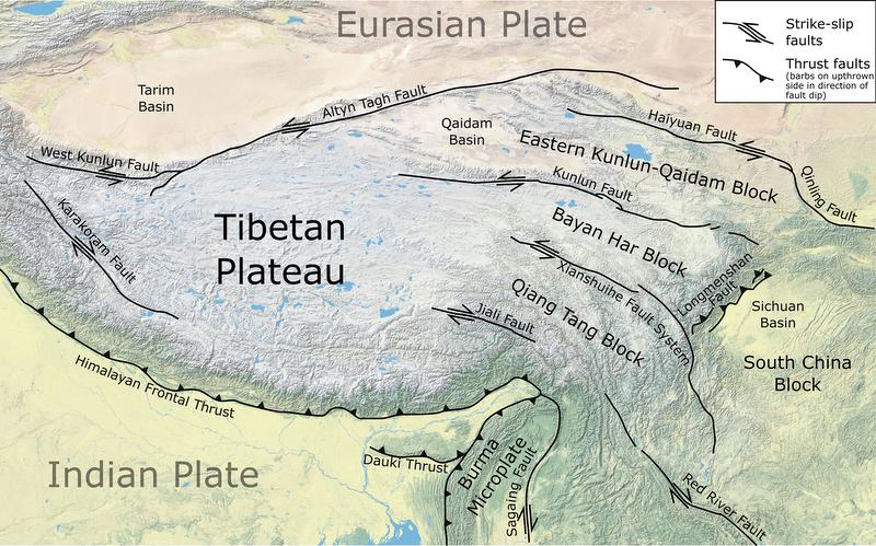
    • Tectonic Context: Located on Indian–Eurasian Plate boundary within Eastern Himalayan Syntaxis (EHS), influenced by the Sunda Plate.
    • Fault Type: Strike-slip motion with thrust faulting — atypical for Himalayan quakes.
    • Plate Convergence: Eastern Himalayas converge at 10–38 mm/year vs. ~20 mm/year elsewhere.
    • Aftershocks: Indicated activation of multiple faults from the Syntaxial bend to Himalayan thrust faults in Arunachal Pradesh.

    Lessons and Future Risks:

    • Magnitude Potential: Confirms Himalayan segments can produce ≥8.6 magnitude events.
    • Central Himalayan Risk: Identified as likely site for similar future quake.
    • Vulnerability Today: Increased due to urbanisation and large infrastructure in seismic zones.
    • Infrastructure Safety: Necessitates strict norms for dams and high-risk projects in Eastern Himalayas.
    • Preparedness: Highlights need for seismic hazard mapping and disaster readiness.
    [UPSC 2024] Consider the following statements:

    1. In a seismograph, P waves are recorded earlier than S waves.

    2. In P waves, the individual particles vibrate to and fro in the direction of waves propogation whereas in S waves, the particles vibrate up and down at right angles to the direction of wave propagation. Which of the statements given above is/are correct?

    Options: (a) 1 only (b) 2 only (c) Both 1 and 2* (d) Neither 1 nor 2


  • Sleeping disasters: Cloudbursts

    Cloud Burst:

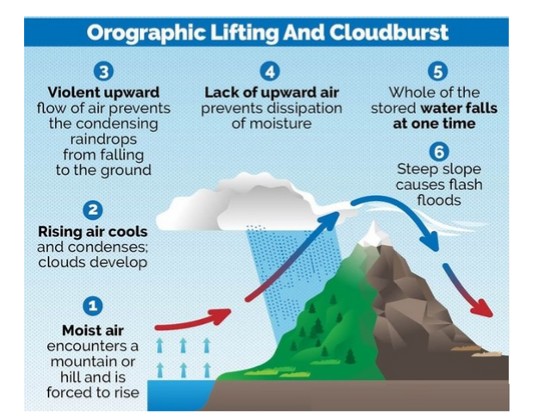
    A cloudburst is an extremely intense, localized shower, defined by the India Meteorological Department (IMD) as at least 100 mm of rain within one hour over 10 sq km. These events occur due to deep, rapid atmospheric uplift over steep terrain, typical of high-altitude Himalayan regions. They can trigger sudden flash floods and landslides, devastating communities in mountainous regions. The term does not refer to a literal bursting cloud but to rapid precipitation from cumulonimbus clouds, sometimes accompanied by thunder or hail.

    Why was the recent Uttarkashi Disaster not a Cloudburst?

    1. Despite initial reports, Uttarkashi district did not record any cloudburst-level rainfall. Actual rainfall was only light to moderate, ranging from 8 mm to 43 mm on Aug 5, far below the 100 mm/hour threshold
    2. The region lacked weather radar coverage at that altitude, so precise measurements were unavailable and the “cloudburst” classification was premature.
    3. Uttarkashi’s steep, rugged topography, with narrow valleys and loose debris, turned the soil into unstable slopes.
    4. A debris-laden flood, possibly triggered by a glacial lake burst, glacier collapse, or landslide, raced downstream as mud and silt-laden water to hit Dharali village violently.

    Reasons for occurrence of cloudbursts:

    1. Cloudbursts happen when warm, moist air quickly rises over mountains, cools down, and turns into heavy rain. This process, called orographic lift, causes the air to release a large amount of rain in a short time.
    2. Sudden mixing of warm and cold air
    3. Strong upward air movement (convection) and high moisture in the air at high altitudes

    Why Do Cloudbursts Happen In The Hills?

    1. Topography: Mountains force moist air to rise rapidly, causing sudden cooling and condensation.
    2. Weather Conditions: Warm air with high moisture content meets cooler air at high altitudes. This results in intense convection and localised torrential rain.

    Can cloudbursts be forecast?

    1. The India Meteorological Department (IMD) forecasts rainfall events well in advance, but it does not predict the quantum of rainfall,  in fact, no meteorological agency does.
    2. IMD gives general rainfall forecasts (light, heavy, very heavy), but not exact amounts.
    3. These forecasts are for large areas like districts or states, not specific locations.
    4. Cloudbursts can’t be predicted exactly due to tech limitations and lack of dense instruments.
    5. However, warnings for very heavy rain (which may lead to cloudburst-like events) are given 6–12 hours in advance.

    Impacts of cloud burst:

    1. Flash Floods: The most immediate and destructive impact is the rapid overflowing of rivers and streams, leading to widespread flooding of low-lying areas.
    2. Landslides and Mudslides: The excessive water saturates the soil on slopes, leading to the rapid downward movement of earth, rocks, and debris, causing significant destruction and posing a threat to human lives and infrastructure.
    3. Soil Erosion: The intense rainfall can wash away topsoil, degrading the land and negatively affecting agriculture.
    4. Land Subsidence: The weakening of the ground due to excessive water absorption can cause the sudden sinking or settling of the Earth’s surface
    5. Loss of Life: The suddenness and intensity of cloudbursts often leave little time for evacuation.
    6. Damage to Infrastructure: Roads, bridges, homes, and public utilities can be severely damaged or completely destroyed.

    While the term “cloudburst” often evokes images of catastrophic floods and landslides, it’s crucial to adopt a nuanced approach, avoiding knee-jerk reactions and recognizing that not all instances of heavy rainfall are cloudbursts. While the unpredictable ferocity of cloudbursts remains a formidable challenge, a proactive blend of scientific innovation, infrastructure resilience, and community-centric preparedness offers the compass to navigate their escalating threat, particularly in fragile ecosystems like the Himalayas.

  • In news: Kamchatka Peninsula

    Why in the News?

    Five strong offshore earthquakes hit Russia’s Kamchatka Peninsula, the strongest measuring 7.4 in magnitude.

    Kamchatka Peninsula

    About Kamchatka Peninsula:

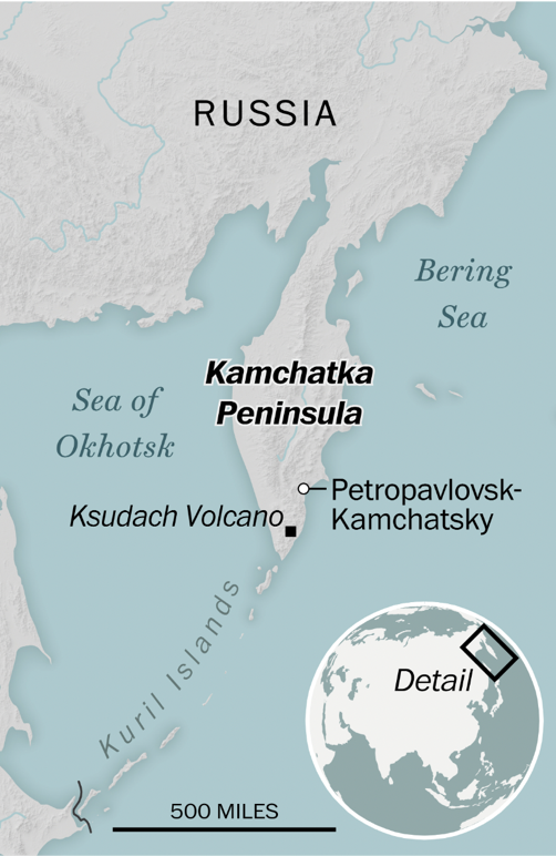
    • Location: Situated in Far Eastern Russia, bordered by the Sea of Okhotsk (west) and the Pacific Ocean and Bering Sea (east).
    • Size and Shape: Stretches about 1,200 km north to south and 480 km at its widest point.
    • Area: Covers approximately 370,000 square kilometers—comparable in size to New Zealand.
    • Ethnic Composition: Majority are ethnic Russians; around 13,000 belong to the indigenous Koryak community.
    • Climate: Harsh with long, snowy winters and wet, cool summers.
    • Topography: Highest peak is Klyuchevskaya Sopka, an active volcano in the Eastern Mountain Range.
    • Global Recognition: Hosts the “Volcanoes of Kamchatka,” a UNESCO World Heritage Site.

    Tectonic Significance:

    • Geological Setting: Lies on the Pacific Ring of Fire, making it a global hotspot for seismic and volcanic activity.
    • Volcanic Density: Contains over 150 volcanoes, 29 of which are currently active.
    • Kuril–Kamchatka Trench: Located just offshore, reaches depths of about 10,500 meters and drives regional seismicity.
    • Tectonic Cause: Caused by subduction of the Pacific Plate beneath the Eurasian Plate.
    [UPSC 2004] Consider the following geological phenomena:

    1. Development of a fault 2. Movement along a fault

    3. Impact produced by a volcanic eruption 4. Folding of rocks

    Which of the above cause earthquakes?

    Options: (a) 1, 2 and 3 (b) 2 and 4 (c) 1, 3 and 4 (d) 1, 2, 3 and 4*


  • In news: Reykjanes Peninsula

    Why in the News?

    Recently a volcano erupted in south-west Iceland, continuing a pattern of recurring geological activity on the Reykjanes Peninsula.

    In news: Reykjanes Peninsula

    About the Reykjanes Peninsula:

    • Location: Situated in southwest Iceland along the Mid-Atlantic Ridge where tectonic plates diverge.
    • Volcanic Reawakening: Dormant for centuries until 2021; now sees recurring eruptions.
    • Eruption Type: Known for fissure eruptions—lava flows from cracks, not a central crater.
    • Key Sites: Includes Grindavik (evacuated), Blue Lagoon spa, and Svartsengi power plant.
    • Volcanic Importance: Part of Iceland’s 30+ active volcanic zones.

    Key Features:

    • Eruption Style: Produces steady lava flows with minimal ash output.
    • Flight Safety: Air traffic remains unaffected due to lack of stratospheric ash.
    • Evacuation Impact: Grindavik largely abandoned after 2023 lava threat.
    • Long-Term Activity: Eruptions may persist for decades or longer.
    • Iceland Snapshot: Population ~400,000; similar in size to Kentucky.
    • Tourism Appeal: Attracts visitors like other volcanic hotspots—Mexico, Indonesia, Sicily, and New Zealand.
    [UPSC 2014] Consider the following geological phenomena:

    1. Development of a fault 2. Movement along a fault

    3. Impact produced by a volcanic eruption 4. Folding of rocks

    Which of the above cause earthquakes?

    Options: (a) 1, 2 and 3 (b) 2 and 4 (c) 1, 3 and 4 (d) 1, 2, 3 and 4*


  • [pib] Fossils reveal Kashmir Valley’s Climatic Past

    Why in the News?

    Researchers from Birbal Sahni Institute of Palaeosciences (BSIP), Lucknow, have found strong evidence that the Kashmir Valley, now cool and temperate, was once a warm, humid subtropical region.

    About the Study on Fossils:

    • Site of Fossil Discovery: The fossils were recovered from the Karewa sediments of the Kashmir Valley, known for preserving ancient plant remains.
    • Analysis: Researchers used CLAMP (Climate Leaf Analysis Multivariate Program) to analyze fossil leaf shape, size, and margins to estimate past temperature and rainfall patterns.
    • Coexistence Approach: It was also used, comparing fossil plants with their modern relatives to reconstruct the region’s ancient climate.

    Key Findings:

    • Past Climate Type: The Kashmir Valley once had a warm, humid subtropical climate, very different from the cool, Mediterranean-type climate it experiences today.
    • Vegetation Evidence: Fossilized leaves showed diverse subtropical plant types no longer found in the region’s current vegetation.
    • Role of Tectonic Uplift: The tectonic uplift of the Pir Panjal Range was identified as a key factor that blocked the Indian summer monsoon from entering the valley.
    • Climatic Transition: This led to gradual drying of the region and a shift from subtropical forests to temperate ecosystems.
    • Impact of Mountain-Building: The study shows that mountain-building (tectonic uplift) can directly affect climate patterns by altering monsoon routes.
    • Relevance to Climate Change: The findings provide insight into natural climate shifts over millions of years, helping contextualize modern climate change.
    • Ecological Vulnerability: It also highlights the fragility of mountain ecosystems like the Himalayas, which are vulnerable to both natural and human-induced environmental changes.

    Back2Basics:

    • Karewa Sediments: They are plateau-like terraces in the Kashmir Valley, made up of lacustrine (lake) and fluvio-glacial deposits; They are known to preserve ancient fossils, especially of plants.
    • Subtropical Climate: A warm and humid climate with moderate to high rainfall, supporting dense vegetation. Ex: Climate of northeastern India.
    • Mediterranean-Type Climate: Characterized by mild, wet winters and hot, dry summers; Ex: Current climate of parts of the Kashmir Valley.


    [UPSC 2025] Which of the following are the evidence of the phenomenon of continental drift?

    I. The belt of ancient rocks from Brazil coast matches with those from Western Africa. II. The gold deposits of Ghana are derived from the Brazil plateau when the two continents lay side by side. III. The Gondwana system of sediments from India is known to have its counterparts in six different landmasses of the Southern Hemisphere.

    Options: (a) I and III only (b) I and II only (c) I, II and III * (d) II and III only