💥Join UPSC 2027,2028 Mentorship (July Batch) + XFactor Notes & Microthemes PDF

GS Paper: GS1-11.Salient Features of World Physical Geography

  • Troposphere is a very significant atmospheric layer that determines weather processes. How?

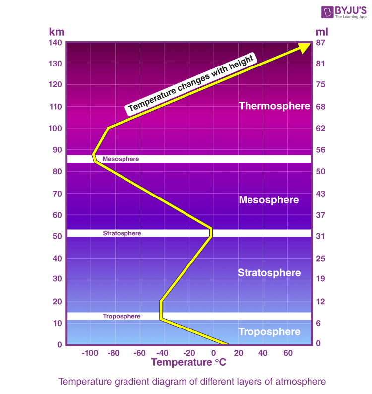
    The troposphere is the lowermost layer of the atmosphere, extending from the Earth’s surface to approximately 8 km at the poles and 18 km at the equator.

    Troposphere- (0-18 km) Weather-active layer. Holds 75% of atmospheric mass.

    Stratosphere- (18-50 km) Home to the ozone layer. Temperature increases with height.

    Mesosphere- (50-85 km) Coldest layer. Meteors burn up here.

    Thermosphere- (85-600 km) Ionosphere location. Facilitates satellite orbits.

    Exosphere- (600 km+) Fades into outer space.

    Significance of Troposphere

    Hydrological Cycle Engine- Holds 99% of atmospheric water vapor, driving all rain and snow.

    Aerosol Nucleation- Hosts dust and pollutants that act as “seeds” for raindrops.

    Environmental Lapse Rate- Temperature drops 6.5°C per km, facilitating cloud-forming condensation.

    Greenhouse Regulation- Contains most CO2 and Methane, maintaining Earth’s habitable temperature.

    Zone of atmospheric convection – Vertical mixing redistributes heat and moisture. Eg- Cumulonimbus cloud development.

    Mass Concentration- Contains 75% of the atmosphere’s mass, providing the pressure needed for winds.

    Boundary Layer Dynamics- The lowest part (PBL) interacts with the surface, determining local microclimates.

    Cyclogenesis Theatre- All tropical and extra-tropical cyclones originate and intensify within this layer.

    Tropopause Lid- Acts as a thermal ceiling, trapping weather within the troposphere.

    Jet streams at upper troposphere steer weather systems. Eg- Subtropical jet influencing Indian winter weather.

    Major Challenges

    Tropospheric Warming- Breach of the 1.5°C threshold has permanently altered weather baselines.

    Increased frequency and intensity of La Niña-El Niño has destabilized global rainfall predictability.

    Polar Vortex Instability- Stratospheric warming is pushing Arctic air into mid-latitudes. Eg- cold waves in Europe.

    Height Expansion- As the troposphere warms, it is physically expanding upward.

    Ground-Level Ozone- Increasing heat is turning tropospheric pollutants into toxic smog.

    Understanding and protecting tropospheric processes is therefore critical for weather prediction, disaster management, and sustainable human survival.

  • What are the forces that influence ocean currents? Describe their role in fishing industry of the world.

    Ocean currents are continuous, directed movements of seawater generated by a combination of physical, climatic, and planetary forces. They regulate heat distribution, nutrient circulation, marine productivity, and global climate.

    Forces Influencing Ocean Currents

    Solar Energy- Differential heating at the equator causes water to expand and rise slightly, creating a gradient that initiates water flow. Eg- Gulf Stream transporting warm water to Europe.

    Temperature Gradients- Cold water is denser and sinks, while warm water is lighter and rises, driving vertical circulation.

    Planetary winds – Trade winds and westerlies drive surface currents. Eg- North Equatorial Current driven by trade winds.

    Coriolis Force- Earth’s rotation deflects moving water to the right in the Northern Hemisphere and the left in the Southern Hemisphere, forming massive circular Gyres.

    Salinity Variations- High salt content increases water density. The interplay of temperature and salt creates the Thermohaline Circulation (The Global Conveyor Belt).

    Continental Configuration- Landmasses deflect currents. Eg- the Brazilian coast bifurcates the Atlantic South Equatorial Current.

    Gravitational pull of Moon and Sun – Generates tidal currents. Eg- Strong tidal currents in Bay of Fundy.

    Ocean basin topography – Submarine ridges and basins redirect flows. Eg- Mid-Atlantic Ridge influencing deep circulation.

    Atmospheric pressure systems – Cyclones and anticyclones alter local currents. Eg- Seasonal reversal in Indian Ocean currents.

    Role of ocean currents in the fishing industry

    Convergence of warm and cold currents – Enhances plankton growth. Eg- Grand Banks (Labrador + Gulf Stream).

    Nutrient redistribution – Currents spread plankton across oceans. Eg- North Sea fisheries supported by Atlantic Drift.

    Temperature regulation – Determines species distribution. Eg- Tuna migration along warm Kuroshio Current.

    Oxygenation of waters – Supports marine biodiversity. Eg- Upwelling off Namibia (Benguela Current).

    Transport of fish larvae – Currents aid breeding and dispersal. Eg- Japanese fisheries influenced by Oyashio Current.

    Formation of rich continental shelf fisheries – Interaction of currents with shallow waters. Eg- Dogger Bank in the North Sea.

    Climate moderation for fishing communities – Eg- Gulf Stream moderating European coasts.

    Fishermen follow current-driven seasonal fish migration patterns. Eg- Monsoon-linked fishing cycles in Arabian Sea.

    El Niño impacts – Disrupts upwelling and fish stocks. Eg- Collapse of Peruvian fisheries during strong El Niño years.

    Climate variability and disruptions like El Niño increasingly threaten these systems, highlighting the need for sustainable and climate-resilient fisheries management.

  • Why is the South-West monsoon called ‘Purvaiya’ (easterly) in Bhojpur Region? How has this directional seasonal wind system influenced the cultural ethos of the region?

    The Monsoon is a seasonal reversal of winds accompanied by corresponding changes in precipitation. In India, it brings nearly 75% of annual rainfall, shaping agrarian, ecological, and cultural life.

    Bay of Bengal Branch branch monsoon winds hit the Purvanchal Himalayas and are deflected westward into the Ganga Plains.

    Coriolis Effect and Meghalaya Plateau help “turn” the southwestern winds into a westward-flowing stream before they reach Bhojpur.

    For the Bhojpur region, the moisture-laden winds arrive from the East/South-East.

    In Bhojpuri, the suffix ‘-aiya’ denotes “originating from”. Thus, winds from the East are called Purvaiya

    Influence of ‘Purvaiya’ on cultural ethos of Bhojpur Region

    Agrarian calendar structuring – Sowing of paddy linked to arrival of Purvaiya.

    Agrarian deities and rituals – Prayers for timely Purvaiya winds. Eg- Indra worship during drought conditions.

    Folk songs and oral traditions – Eg- Purvaiya is personified in Kajri songs as a messenger of love and longing for women waiting for their husbands.

    Emotional-cultural symbolism – Rain as metaphor for longing and reunion. Eg- Bhojpuri cinema and poetry portraying Purvaiya romantically.

    Festivals of Fertility- Hariyali Teej and Nag Panchami celebrate the rejuvenation of the earth brought by the moisture-laden Purvaiya.

    Architectural adaptation – Sloped roofs and raised plinths designed for heavy rainfall. Also, eastern-facing verandahs (Dalan) to catch the cooling breeze.

    Culinary patterns – Seasonal foods linked to rainy months. Eg- Consumption of saag, pakoras, and millets during monsoon.

    Traditional “Madhubani painting” also depicts purvailya frequently.

    Thus, Purvaiya highlights the deep interlinkage between climate and culture in the Indo-Gangetic plains.

  • How are the fjords formed? Why do they constitute some of the most picturesque areas of the world?

    A fjord is a long, narrow, and deep sea inlet with steep cliffed sides, formed due to glacial erosion and subsequent marine submergence.

    Formation of fjords

    Glacial Erosion of Pre-existing River Valleys

    During the Ice Age, valley glaciers occupied pre-existing river valleys.

    Through processes like plucking and abrasion, glaciers deepened and widened these valleys.

    This produced a characteristic U-shaped glacial trough with very steep sides.

    Overdeepening of the Valley Floor

    Glaciers erode the central part more intensely due to greater ice thickness.

    This creates basins that are often deeper than the adjoining sea.

    Reduced erosion near the glacier’s snout leaves a shallow entrance (threshold or sill).

    After the melting of glaciers, sea level rose and drowned the glacial trough. Seawater filled the valley forming a fjord.

    Fjords are among the most picturesque landscapes due to

    Steep and Towering Cliffs rising dramatically from the water attract adventure tourists. Eg- Sognefjord (Norway).

    Deep, narrow inlets create a mirror-like water surface. This enhances visual beauty through reflection of peaks and clouds

    Tributary glaciers form hanging valleys. After glaciation, these become spectacular waterfalls. Eg- Milford Sound (New Zealand).

    Vibrant Contrasts- The deep blue cold, oxygen-rich water provides a sharp color contrast against the dark granite rocks and white snow on the summits.

    Indented Coastline creates numerous bays, islands, and peninsulas, giving a highly irregular and scenic coast.

    Fjords have their own sheltered micro-climates, allowing for blossoms or orchards at the base of snowy mountains

    Unique Light and Climatic Effects – High latitude locations produce long daylight hours, auroras, and misty environments.

    Fjords represent classic glacio-fluvial and marine interaction. They also serve as important centres for tourism, fisheries, and human settlement.

    Economic geography