💥Join UPSC 2027,2028 Mentorship (August Batch) + XFactor Notes & Microthemes PDF

GS Paper: India & Its Neighborhood – Relations

  • Changing dynamics in China-Pakistan collusion against India

    India has always been aware of the China-Pak collusion and their mutual support to each others’ actions. But the underlying basis has been changing now. It is no longer Pakistan seeking Chinese support in J&K as much as it is the other way around.

    Preparedness for a two-front war

    • The debate regarding India’s capability to fight a war in which there is full collusion between China and Pakistan has generally remained inconclusive.
    • Most detractors of the belief regarding China’s military-operational support to Pakistan, have leaned on the argument that China will adopt a policy to suit its interests.
    • Both in 1965 and 1971, China made some promises to Pakistan but chose to stay away.
    • Of course, that was during the Cold War — a completely different international strategic environment.

    China-Pakistan collection action in Kashmir

    • Pakistan increased its proxy campaign in J&K almost in sync with two China-related trends.
    • First, enhanced PLA assertiveness in Eastern Ladakh.
    • Second, the announcement of the Belt and Road Initiative (BRI).
    • A progressively altering Chinese attitude towards the Kashmir issue started to take shape as early as 2008-09, with issuing stapled visas to Indians residing in J&K and denial of a visa to the Northern Army Commander were signs of it.
    • This support was also witnessed on issues like the Nuclear Suppliers Group (NSG), Pakistan’s involvement in global terrorism and the abrogation of Article 370.

    Pincer approach in Ladakh

    • It is no longer Pakistan seeking Chinese support for its adventurism as much as it is the other way around.
    • The mutuality of interests has increased and military coordination has become a larger part of the overall strategy.
    • China may force further escalation this season depending upon how the world responds to its expansionism.
    • China could also adopt a posture which prepares it, along with Pakistan, towards a future “pincer approach” in Ladakh.
    • Along with Ladakh — Arunachal, Sikkim and the Central Sector are very part of the expanded collusive strategy.
    • But it is Ladakh where the effect is intended most and it is there that the pincer approach may prove more challenging for India.

    Suggestions for India

    • Assuming that confrontation with the Sino-Pak combine is inevitable now or later, one of the ways for India to offset this is to project sufficient capability.
    • The diplomatic and military domains have to play this out effectively.
    • India cannot be seen to be alone or militarily weak.
    • It has tremendous support internationally which must translate into a higher level of strategic support.
    • Militarily, Pakistan should never be able to perceive that it will be allowed to fight as per choice and conceived strategy.
    • China’s success or failure in such adventurism will set the course of its future strategy against its multiple adversaries.
    • That is the psyche which India must exploit to prevent escalation and win this and impending standoffs without fighting.
    • This needs a rapid and all-out national effort with the highest priority accorded to it, including budgeting.

    Conclusion

    India cannot afford to focus only on the northern borders. A firm and full strategy to deal with Pakistan in all contingencies has now become imperative.

  • Azad Pattan Hydel Project

    Pakistan and China have signed an agreement for the 700 MW Azad Pattan hydel power project on the Jhelum River in Sudhoti district of PoK.

    Try this question from CSP 2019:

    Q.What is common to the places known as Aliyar, Isapur and Kangsabati?

    (a) Recently discovered uranium deposits

    (b) Tropical rain forests

    (c) Underground cave systems

    (d) Water reservoirs

    Azad Pattan hydel project

    • The project is a run-of-the-river scheme with a reservoir located near Muslimabad village, 7 km upstream from the Azad Pattan bridge, in district Sudhnoti, one of the eight districts of PoK.
    • It is one of five hydropower schemes on the Jhelum.
    • Upstream from Azad Pattan are the Mahl, Kohala, and Chakothi Hattian projects; Karot is downstream. Like Kohala and Azad Pattan, Karot too is being developed under the CPEC framework.
    • The project will comprise a 90-metre-high dam, with a 3.8 sq km reservoir.
    • The $ 1.5-billion project is the second power project under the China Pakistan Economic Corridor (CPEC).

    Other projects in PoK

    • Kohala project is a 1,124 MW hydel project that will come upon the Jhelum near Muzaffarabad. This project is one of the biggest investments by China in PoK.
    • The Karot Hydropower station, the third project being executed by China on the Jhelum is on the boundaries of Kotli district in PoK and Rawalpindi district in Pakistan’s Punjab province.
    • Two hydel projects are planned in Gilgit Baltistan – Phandar Hydro Power, and Gilgit KIU.
    • Most recent in the news was Diamer-Bhasha dam in the PoK.
  • India’s Military Ties with Nepal

    Soldiers from Nepal form a significant part of the Indian Army’s legendary Gurkha regiment. Here is a brief explainer on the origin and evolution of these ties.

    Practice question for mains:

    Q.“India has special and time-tested military ties with Nepal”. Analyse.

    India’s military ties with Nepal: The origin

    • India’s military connection with the Himalayan country goes back to the reign of Maharaja Ranjit Singh whose army in Lahore enlisted Nepalese soldiers called Lahure or soldiers of fortune.
    • British India raised the first battalion of the Gurkha Regiment as the Nasiri regiment on April 24, 1815.
    • By the time the First World War started, there were 10 Gurkha regiments in the British Indian Army.
    • When India got freedom, these regiments were divided between the British and Indian armies as per the Britain–India–Nepal Tripartite Agreement signed in November 1947.
    • Six Gurkha regiments with a lakh-odd soldier came to India, which went on to raise another regiment called 11 Gurkha Rifles who chose not to transfer to the British Army.

    Can Nepali citizens join the Indian Army?

    • Yes, any Nepali can join the Indian Army, both as a jawan and as an officer.
    • A citizen of Nepal can take the NDA or CDS exams and join the Indian Army as an officer.
    • Col Lalit Rai, who received a Vir Chakra for the bravery of his battalion, the 1/11 Gurkha Rifles, during the Kargil war, is one such officer of Nepalese descent.
    • The Nepalese army also sends its officers for training to India’s military academies and combat colleges.

    Do the soldiers from Nepal enjoy the same rights as the Indian troops?

    • Yes, they enjoy the same benefits as the India troops both during service and after retirement.
    • They get the same medical facilities as the Indian soldiers, and often medical teams from the Indian Army tour Nepal.
    • Unlike the British, who started giving the Nepalese soldiers pension only a few years ago, the Indian Army has never discriminated against the Nepalese soldiers, who can avail of healthcare facilities in India as well.
    • The Indian Army also runs welfare projects in Nepal villages, including small water and power projects.

    The honorary chief of the Nepalese army

    • Yes, this convention dates back to 1972 when then Field Marshal Sam Manekshaw, a Gurkha regiment officer, fondly called Sam Bahadur by his troops, was made the honorary chief of the Nepalese army.
    • Ever since the Army chief of India is the honorary chief of the Nepalese army and vice-versa.

    Joint exercises

    • Joint military exercise ‘SURYA KIRAN is an annual event which is conducted alternatively in Nepal and India.
    • It is an important exercise in terms of the security challenges faced by both nations in the realm of changing facets of global terrorism.
  • Chabahar Rail Project

    The Iranian government has decided to proceed with the construction of Chabahar Rail Project on its own, citing delays from the Indian side in funding and starting the project.

    What is the issue?

    • Four years ago, India and Iran signed an agreement to construct a rail line from Chabahar port to Zahedan, along the border with Afghanistan.
    • The Iranian Railways will proceed without India’s assistance, using approximately $400 million from the Iranian National Development Fund.
    • The development comes as China finalizes a massive 25-year, $400 billion strategic partnership deal with Iran, which could cloud India’s plans.

    The Chabahar Rail Project

    • It is a 628 km Chabahar-Zahedan line, which will be extended to Zaranj across the border in Afghanistan.
    • The entire project would be completed by March 2022.
    • It was meant to be part of India’s commitment to the trilateral agreement between India, Iran and Afghanistan to build an alternate trade route to Afghanistan and Central Asia.

    Why did Iran omit India from the project?

    • Despite several site visits by engineers, and preparations by Iranian railways, India never began the work, ostensibly due to worries that these could attract U.S. sanctions.
    • The U.S. had provided a sanctions waiver for the Chabahar port and the rail line to Zahedan, but it has been difficult to find equipment suppliers and partners due to worries they could be targeted by the U.S.
    • India has already “zeroed out” its oil imports from Iran due to U.S. sanctions.

    The contentious partnership with China

    • Iran and China are close to finalising a 25-year Strategic Partnership which will include Chinese involvement in Chabahar’s duty-free zone, an oil refinery nearby, and possibly a larger role in Chabahar port as well.
    • The cooperation will extend from investments in infrastructure, manufacturing and upgrading energy and transport facilities, to refurbishing ports, refineries and other installations.
    • It is also rumoured that the Chabahar port will be leased to China surpassing India.
    • Iran had proposed a tie-up between the port at Gwadar and Chabahar last year and has offered interests to China in the Bandar-e-Jask port 350km away from Chabahar, as well as in the Chabahar duty-free zone.

    Back2Basics: India-Iran Partnership over Chabahar Port

    • In 2016, India signed a deal with Iran entailing $8 billion investment in Chabahar port and industries in Chabahar Special Economic Zone.
    • The port is being developed as a transit route to Afghanistan and Central Asia.
    • India has already built a 240-km road connecting Afghanistan with Iran.
    • All this were expected to bring cargo to Bandar Abbas port and Chabahar port, and free Kabul from its dependence on Pakistan to reach the outer world.
    • Completion of this project would give India access to Afghanistan and beyond to Turkmenistan, Uzbekistan, Tajikistan, Kyrgyzstan, Kazakhstan, Russia and Europe via 7,200-km-long multi-modal North-South Transport Corridor (INSTC).
  • Patrolling Points along LAC

    The standoffs between Indian and Chinese troops in Ladakh on the Line of Actual Control (LAC), where initial steps towards disengagement have taken place, are around a number of patrolling points or PPs in Galwan, Hot Springs and Gogra areas.

    Do you know?

    The Galwan River flows from the Aksai Chin region occupied by China in the UT of Ladakh.  It originates in the area of Samzungling on the eastern side of the Karakoram Range and flows west to join the Shyok River.  It is one of the upstream tributaries of the Indus River.

    What exactly are Patrolling Points?

    • PPs are patrolling points identified and marked on the LAC, which are patrolled with a stipulated frequency by the security forces.
    • They serve as a guide to the location of the LAC for the soldiers, acting as indicators of the extent of ‘actual control’ exercised on the territory by India.
    • By regularly patrolling up to these PPs, the Indian side is able to establish and assert its physical claim about the LAC.

    Are all the Patrolling Points numbered?

    • Some of the PPs are prominent and identifiable geographical features, such as a pass, or a nala junction where no numerals are given.
    • Only those PPs, where there are no prominent features, are numbered as in the case of PP14 in Galwan Valley.

    Do all Patrolling Points fall on the LAC?

    • Mostly, yes. Except for the Depsang plains in northern Ladakh, where PP10, PP11, PP11A, PP12 and PP13 – from Raki Nala to Jivan Nala – do not fall on the LAC.
    • These are short of the LAC, on the Indian side.

    Are these Patrolling Points not manned?

    • The PPs are not posts and thus not manned. Unlike on the Line of Control (LoC) with Pakistan, the border with China is not physically held by the Army all along.
    • They are just physical markers on the ground, chosen for their location and have no defensive potential or tactical importance for the Army.

    How is the claim asserted on LAC?

    • The claim is asserted by the Army or joint Army-ITBP patrols as they show more visible presence in these areas.
    • This is done by physically visiting PPs with a higher frequency, as the deployment has moved closer to the LAC and due to improved infrastructure.
    • As the Chinese may not see when the Indian patrols visit these PPs, they will leave come cigarette packets or food tins with Indian markings behind.
    • That lets the Chinese know that Indian soldiers had visited the place, which indicates that India was in control of these areas.

    Who has given these Patrolling Points?

    • These PPs have been identified by the high-powered China Study Group, starting from 1975 when patrolling limits for Indian forces were specified.
    • It is based on the LAC after the government accepted the concept in 1993, which is also marked on the maps with the Army in the border areas.
    • But the frequency of patrolling to PPs is not specified by the CSG – it is finalised by the Army Headquarters in New Delhi, based on the recommendations made by the Army and ITBP.

    PP under dispute

    • PPs 10 to 13 in Depsang sector, PP14 in Galwan, PP15 in Hot Spring, and PP17 and PP17A in Gogra are currently being disputed by both sides, where the standoffs have taken place in the past nine weeks.
  • U.S. stance on CAATSA unchanged

    Recently India had planned for the purchase of Mig-19 fighter aircraft with Russia at an estimated Rs. 18,148 crore. The U.S has reacted to countries, including India, on sanctions for the purchase of Russian arms has not changed.

    Practice question for mains:

    Q.What is CAATSA law? Discuss how it will impact India’s ties with Russia.

    About CAATSA

    • CAATSA stands for Countering America’s Adversaries through Sanctions Act (CAATSA).
    • It is a US federal law that imposed sanctions on Iran, North Korea, and Russia.
    • The bill provides sanctions for activities concerning:

    (1) cybersecurity, (2) crude oil projects, (3) financial institutions, (4) corruption, (5) human rights abuses, (6) evasion of sanctions, (7) transactions with Russian defence or intelligence sectors, (8) export pipelines, (9) privatization of state-owned assets by government officials, and (10) arms transfers to Syria.

    A cause of worry

    • While the US has become its second-largest defence supplier, mainly of aircraft and artillery, India still relies heavily on Russian equipment, such as submarines and missiles that the US has been unwilling to provide.
    • Seventy per cent of Indian military hardware is Russian in origin.
    • India is set to receive the S-400 Triumf air defence system.

    Is India the only country facing CAATSA sanctions?

    • Notably, Russia is India’s major defence supplier for over 6 decades now, and Iran is India’s second-largest oil supplier.
    • By coincidence, CAATSA has now been invoked by the US twice already, and both times for countries buying the Triumf system from Russia.
    • In September 2018, the US announced sanctions for the procurement of the S-400 Triumf air defence system and Sukhoi S-35 fighter aircraft.
    • Washington expelled Turkey from the F-35 fighter jet programme in July this year after the first delivery of S-400s was received.
    • India is neither like China, which has an inimical relationship with the U.S., and hence not bound by its diktats, nor like Turkey which is a NATO ally of the US.
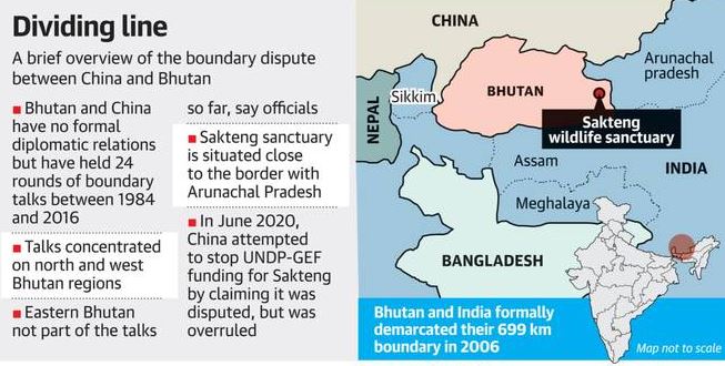
  • Sakteng Wildlife Sanctuary

    In a bid to further its territorial ambitions, China has recently claimed the Sakteng wildlife sanctuary in Eastern Bhutan as its own territory.

    Practice question for mains:

    Q.What are the various fronts of Chinese imperial expansionism across the South Asian Region?

    About the Sakteng WLS

    • Sakteng is a wildlife sanctuary located mostly in Trashigang District and just crossing the border into Samdrup Jongkhar District, Bhutan.
    • It is one of the country’s protected areas.
    • It is listed as a tentative site in Bhutan’s Tentative List for UNESCO inclusion.

    Certain unresolved issues

    • The boundary between China and Bhutan has never been delimited.
    • There have been disputes over the eastern, central and western sectors for a long time.
    • China last month attempted to stop funding for the Sakteng sanctuary from the U.N. Development Programme’s Global Environment Facility (GEF) on the grounds that it was “disputed” territory.

    Reasons for the dispute

    • According to written records, there has been no mention of Eastern Bhutan, or Trashigang Dzongkhag (district), where Sakteng is based as per boundary negotiations held between the two countries between 1984 and 2016.
    • The negotiations have not been held since the Doklam standoff between Indian and Chinese troops in 2017.
    • Bhutan has always maintained a discreet silence on its boundary negotiations with China, and it does not have any formal diplomatic relations with Beijing.
  • Ladakh and its Geo-strategic Importance

    With the long-standing border standoff with China, Ladakh, a rugged, high-altitude region that is generally far removed from the lives and imagination of most Indians, has become part of our daily conversations and worries.

    Let’s have a look at a short primer on the region, its history, and some of the places where Indian soldiers are locked in conflict with the Chinese army. Try remembering its geographical features.

    Ladakh through the History

    • Lying between the Kunlun mountain range in the north and Himalayas to the south, Ladakh was originally inhabited by people of Indo-Aryan and Tibetan descent.
    • Historically the region included the valleys of Baltistan, Indus, and Nubra, besides Zanskar, Lahaul and Spiti, Aksai Chin, Ngari and Rudok.
    • Located at the crossroads of important trade routes since ancient times, Ladakh has always enjoyed great geostrategic importance.
    • At the beginning of the first century AD, Ladakh was part of the Kushan Empire. Till the 15th century, it was part of Tibet and was ruled by dynasties of local Lamas.
    • Later it changed hands multiple times, alternating between the kingdoms of Kashmir and Zhangzhung.
    • In 1834, Gen Zorawar Singh, a general of Raja Gulab Singh who ruled Jammu as part of the Sikh empire, extended the boundaries of Maharaja Ranjit Singh’s kingdom to Ladakh.

    Partition, Pakistan and Chinese occupations

    Immediately after India’s Partition, tribal raiders (the disguised Pakistani Army) attacked Ladakh. They captured Kargil and were heading for Leh when they were confronted by the Indian Army, who got back Kargil.

    • Although India has always considered Aksai Chin to be part of Jammu and Kashmir, in the 1950s the Chinese built a highway, called western highway or NH219, connecting Tibet with Xinjiang through this region.
    • It was always more easily accessible to the Chinese than to the Indians, who were across the Karakoram.
    • India learnt of this road in 1957, and it was one of the causes of the 1962 India-China war, after which China strengthened its control over this region.
    • China today claims Aksai Chin to be part of Hotan County of its Xinjiang province.
    • Pakistan ceded the Shaksgam Valley, which was part of the Baltistan region north of the Karakoram, to China following a Sino-Pakistani agreement signed on March 2, 1963.

    Ladakh through the Chinese eyes

    • China’s forays into the region began after the 1949 Communist Revolution, when Chairman Mao Zedong, a veteran of guerrilla warfare, began consolidating China’s periphery as part of his expansionist designs.
    • The PLA occupied Tibet in 1951 and then began to eye Ladakh.
    • The reason was that the road connecting Kashgar in Xinjiang to Lhasa in Tibet had to pass through Aksai Chin, which was held by Indians but was seldom patrolled by them.

    Galwan Valley in the limelight

    • The Tibetan revolt of 1959 and the Dalai Lama’s flight to India saw China further strengthening its military presence in Ladakh to ensure the security of NH 219.
    • India reacted with its ‘forward policy’ as part of which it began setting up Army posts in the region to prevent Chinese expansion.
    • This resulted in the initial clash between the Indian and Chinese forces in the Kongka Pass area in 1959.
    • Later, Galwan Valley became the scene of action when the Indian Army established a post to cut off the Chinese post in the Samjunjling area, marking the beginning of the 1962 war.

    Pangong Tso: The contested lake

    • In the latest face-off, Indian troops first spied the Chinese on the banks of Pangong Tso.
    • This lake, which is one-third in India and two-thirds in China, is of great tactical significance to the Chinese who have built infrastructure along both its sides to ensure the speedy build-up of troops.
    • Chinese incursions in this region aim at shifting the LAC westward so that they are able to occupy important heights both on the north and the south of the lake, which will enable them to dominate the Chushul Bowl.
    • The narrow Chushul valley, which lies on the road to Leh with Pangong Tso to its north, was an important target for the Chinese even during the 1962 war. It was here that the Battle of Chushul was fought.

    Strategic SSN: To the far north

    • The area spanning Galwan, Depsang plateau, and Daulat Beg Oldie (DBO), is called Sub-Sector North (SSN).
    • This enclave that lies to the east of the Siachen glacier is of immense significance given its proximity to the Karakoram Pass, close to China’s western highway or NH 219 going to Aksai Chin.
    • It’s the SSN that provides land access to Central Asia through the Karakoram Pass.
    • Domination of this area is also crucial for the protection of the Siachen glacier, lying between the Saltoro ridge on the Pakistani side and the Saser ridge close to the Chinese claim line.
    • The Galwan heights overlook the all-weather Durbuk-Shyok-Daulat Beg Oldie (DSDBO) Road, which connects Leh to DBO at the base of the Karakoram Pass that separates China’s Xinjiang Region from Ladakh.
    • Domination over these heights allows China to easily interdict this road.

    Why is China stubborn on Galwan?

    • Occupation of Galwan will neutralize the tactical advantage India gained by building the all-weather Durbuk-DBO road over the last two decades.
    • Last year, the Border Road Organisation (BRO) made this rugged terrain even more accessible by completing the 430-metre-long bridge across the Shyok River.
    • With this, the Darbuk route to DBO became available round the year, and the travel time of troops to the SSN was halved.
    • It was this bridge, coupled with the ongoing work on a link road to LAC in this area, prompted the PLA to enter Galwan.
  • Timbuktu: The faraway land

    Timbuktu is a western African city whose name is a metaphor for a place too exotic and remote to even imagine, now is in the grasp of Covid-19.

    Try this question from CSP 2018:

    Q.Very recently, in which of the following countries have lakhs of people either suffered from severe famine/acute malnutrition or died due to starvation caused by war/ethnic conflicts?

    (a) Angola and Zambia

    (b) Morocco and Tunisia

    (c) Venezuela and Colombia

    (d) Yemen and South Sudan

    Timbuktu

    • Timbuktu is a city in Mali, situated 20 km north of the Niger River.
    • The mystique of Timbuktu owes a lot to its inaccessibility, which continues even today.
    • It is located on the southern tip of the Sahara desert where there is nothing but thousands of miles of barren desert to its north.
    • It was a regional trade centre in medieval times, where caravans met to exchange salt from the Sahara Desert for gold, ivory, and slaves from the Sahel, which could be reached via the nearby Niger River.
  • West Bank Annexation Plan

    Israeli PM Benjamin Netanyahu confirmed that the Israeli leader’s plan to annex parts of the occupied West Bank would not start on the original target date as the British PM made an extraordinary appeal to Israel to call off the plan.

    The strategic location of Gaza strip, West Bank, Dead Sea etc. creates a hotspot for a possible map based prelims question. 

    Consider this PYQ from 2015 CSP:

    Q. The area known as ‘Golan Heights’ sometimes appears in the news in the context of the events related to:

    a) Central Asia
    b) Middle East
    c) South-East Asia
    d) Central Africa

    Must read:

    [Burning Issue] West Asia Peace Plan

    Where is West Bank Located?

    • The West Bank is located to the west of the Jordan River.
    • It is a patch of land about one and a half times the size of Goa, was captured by Jordan after the 1948 Arab-Israeli War.
    • Israel snatched it back during the Six-Day War of 1967 and has occupied it ever since.
    • It is a landlocked territory, bordered by Jordan to the east and Israel to the south, west, and north.
    • Following the Oslo Accords between the Israeli government and the Palestine Liberation Organization (PLO) during the 1990s, part of the West Bank came under the control of the Palestinian Authority.
    • With varying levels of autonomy, the Palestinian Authority controls close to 40 per cent of West Bank today, while the rest is controlled by Israel.