💥Join UPSC 2027,2028 Mentorship (August Batch) + XFactor Notes & Microthemes PDF

GS Paper: GS1-15.Geographical features and their location- Changes in critical geographical features (including water-bodies and ice-caps) and in flora and fauna and the effects of such changes.

  • In news: Seine River

    Why in the News?

    French authorities have opened up the Seine River to public swimming for the very first time since 1923.

    In news: Seine River

    About the Seine River:

    • Overview: it is a major waterway in northern France, flowing through some of the country’s most important cultural and economic regions.
    • Length and Rank: It is approximately 777 km(483 miles) long, making it the second-longest river in France after the Loire.
    • Source and Elevation: It originates from the Langres Plateau in the Burgundy region, near the town of Source-Seine, at an elevation of about 444–471 meters above sea level.
    • Course Through France: It flows northwest, passing through regions such as Burgundy, Champagne, and Île-de-France, and cities like Troyes, Melun, Corbeil, and Paris.
    • Path Through Paris: In Paris, the Seine winds through the city center for about 13 kilometers, forming the famous islands Île de la Cité and Île Saint-Louis.
    • Tributaries: It is joined by several important tributaries, including the Marne, Yonne, Aube, and Oise rivers.
    • Drainage Basin and Rainfall: Its drainage basin spans 76,000–79,000 square kilometers, receiving moderate rainfall of 650–750 mm annually, and covering much of northern France.
    • Mouth and Termination: The river empties into the English Channel between Le Havre and Honfleur, on the Normandy coast.
    • Economic Role: The Seine supports commercial navigation and shipping, especially through the ports of Rouen and Le Havre, and provides about 50% of Paris’s drinking water.
    [UPSC 2020] Consider the following pairs: River Flows into

    1. Mekong Andaman Sea 2. Thames Irish Sea 3. Volga Caspian Sea 4. Zambezi Indian Ocean Which of the pairs given above is/are correctly matched?

    Options: (a) 1 and 2 only (b) 3 only (c) 3 and 4 only* (d) 1, 2 and 4 only


  • How India ‘added’ more than 3,500 km to its coastline

    Why in the News?

    India’s coastline has increased by about 48%, not because of new land but due to better digital mapping and updated measurements. It has grown from 7,516 km to 11,098 km, giving a clearer view of the country’s natural borders.

    What led to the increase in India’s measured coastline length?

    • Use of High-Resolution Mapping Technology: The shift from low-resolution (1:4,500,000) to high-resolution data (1:250,000) allowed finer measurement of the coastline’s bends and curves. Eg: Modern GIS software captured intricate coastal shapes that older manual methods missed.
    • Inclusion of Previously Omitted Offshore Islands: Many small offshore islands that were earlier not visible or excluded due to manual limitations are now included. Eg: Several minor islands around the Andaman & Nicobar and Lakshadweep regions added extra coastline length.
    • Coastline Paradox and Irregularity of Landforms: Coastlines are naturally irregular; measuring them at a finer scale captures more detail, thus increasing total length. Eg: Like using a one-meter ruler instead of a one-kilometre one—more small features are counted, increasing overall length.

    Why is the coastline paradox relevant to India’s coastal mapping?

    • Scale-Dependent Measurement: The coastline paradox shows that a coastline’s length varies based on the scale or resolution used for measurement—the finer the scale, the longer the coastline appears. Eg: Measuring with 1:250,000 scale data gives a much longer length than with 1:4,500,000 scale data.
    • Irregular Nature of Coastlines: Coastlines are highly irregular, full of bends, curves, and inlets, which get missed at lower resolutions but captured at higher ones. Eg: A low-resolution map smooths out land features, while high-resolution GIS tools map every minor curve.
    • No Fixed Length: The paradox proves that coastlines do not have a finite length—they can always be measured in more detail, leading to ever-changing figures. Eg: Even with current high-tech tools, the actual coastline length keeps increasing with better precision in future reassessments.

    How does reassessing the coastline and islands impact governance and security?

    • Accurate Administrative and Developmental Planning: Reassessment provides a clear understanding of territorial boundaries, aiding in efficient governance and infrastructure development. Eg: Updated coastline data helps plan coastal roads, ports, and disaster response systems in states like Gujarat and West Bengal.
    • Strengthening Maritime Security and Surveillance: Precise mapping helps in identifying vulnerable points, enabling better deployment of naval and coast guard resources. Eg: Mapping of remote islands assists in setting up radar stations and surveillance posts in regions like Lakshadweepand Andaman & Nicobar.
    • Strategic Assertion and Environmental Management: Helps in asserting sovereignty over maritime zones and managing coastal ecosystems more effectively. Eg: Reassessment supports India’s claim over its Exclusive Economic Zone (EEZ) and strengthens climate resilienceplanning in coastal areas.

    What challenges exist in accurately counting India’s offshore islands?

    • Ambiguity in Definitions and Tidal Variations: Some landforms may appear as islands during high tide but get connected to the mainland during low tide, causing confusion in classification. Eg: Certain coastal features in Sundarbans and Gulf of Khambhat shift between island and non-island status based on tide levels.
    • Discrepancies Across Agencies and Lack of Standardisation: Different agencies like state governments, Coast Guard, and Surveyor General have reported varying island countsdue to inconsistent definitions and methods. Eg: In 2016, the Surveyor General listed 1,382 islands, while other agencies reported 1,334, leading to a need for data reconciliation.

    Way forward: 

    • Standardised Methodology and Regular Reassessment: Adopt a uniform classification system for islands and coastlines across all agencies, and institutionalise periodic reassessments using high-resolution GIS and satellite data every 10 years.
    • Integrated Coastal Management and Strategic Mapping: Develop a centralised coastal database linking administrative, ecological, and security data to support policy-making, climate resilience, and maritime defence planning.

    Mains PYQ:

    [UPSC 2024] In a crucial domain like the public healthcare system, the Indian State should play a vital role to contain the adverse impact of marketisation of the system. Suggest some measures through which the State can enhance the reach of public health care at the grassroots level.

    Linkage: This article explicitly highlights alcohol consumption as a significant public health issue in India, leading to injuries, mental illness, non-communicable diseases like cancer, and contributing to approximately 2.6 million Disability-Adjusted Life Years (DALYs) in 2021.

  • Shipki La Mountain Pass opened for Tourists

    Why in the News?

    For the first time since India’s independence, the Shipki La pass in Himachal Pradesh has been opened to domestic tourists, marking a historic shift in India’s border tourism strategy.

    About Shipki La Pass:

    • It is a high-altitude mountain pass at 3,930 meters in the Kinnaur district of Himachal Pradesh, on the India–Tibet (China) border.
    • It is one of only 3 official border trading points between India and Tibet, along with Nathu La (Sikkim) and Lipulekh (Uttarakhand).
    • The Sutlej River (called Langqen Zangbo in Tibet) enters India near Shipki La, adding geographical importance to the area.
    • The pass lies along National Highway 5 (NH5) and is considered one of the highest motorable roads in India.
    • Historically, it served as a major trade route, enabling exchange of salt, wool, spices, yak tails, and tea between India and Tibet.
    • Trade was stopped in 1962 after the India-China war, resumed in 1992, but was halted again during COVID-19.
    • On June 9, 2025, Himachal Pradesh opened the pass to Indian tourists for the first time since Independence.
    • The initiative is part of a “Border Tourism” strategy, which includes the launch of the Sarhad Van Udyan (Border Forest Park).
    • It is also being considered as an alternate route for the Kailash Mansarovar Yatra.

    Other Important Himalayan Passes:

    • Ladakh and Jammu & Kashmir:
      • Khardung La (5,359 m) – Among the highest motorable passes; connects Leh with Nubra Valley.
      • Zoji La – Links Srinagar with Leh; vital for year-round Ladakh access.
      • Chang La, Baralacha La, Umling La (5,798 m) – Crucial for Leh connectivity and defense.
      • Rezang La – Famous for the 1962 India-China war battle.
      • Karakoram Pass, Aghil Pass, Demchok Pass – Strategic India-China border passes.
    • Himachal Pradesh:
      • Rohtang Pass – Connects Kullu with Lahaul-Spiti; key for tourism and logistics.
      • Parang La – Links Spiti Valley and Parvati Valley; used by trekkers and herders.
      • Shipki La – Now open to tourists; historical Indo-Tibetan trade route.
    • Uttarakhand:
      • Lipulekh Pass (5,632 m) – Used for Kailash Mansarovar Yatra.
      • Mana Pass – One of the highest vehicle-accessible passes; connects to Tibet.
      • Niti Pass, Milam Pass, Kuthi Pass – Historical trade and pilgrimage routes.
    • Sikkim:
      • Nathu La – Major border trade route; part of the ancient Silk Route.
      • Jelep La – Historical route linking Sikkim with Lhasa via Chumbi Valley.
    • Arunachal Pradesh:
      • Se La, Bum La – Connect to Tawang and Bhutan border.
      • Pangsau Pass, Diphu Pass – Connect Arunachal with Myanmar; important for WWII history and connectivity.
    [UPSC 2007] Which one of the following Himalayan passes was reopened around in the middle of the year 2006 to facilitate trade between India and China?

    Options: (a) Chang La (b) Jara La (c) Nathu La (d) Shipki La


  • Places in news: Mt. Khangchendzonga

    Why in the News?

    Sikkim’s CM has asked the Centre to ban climbing on Mt. Khangchendzonga, even from the Nepal side, as the mountain is sacred to the Sikkimese and seen as a guardian deity.

    About Mt. Khangchendzonga:

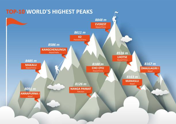
    • Location: Mt. Khangchendzonga is the third-highest mountain in the world at 8,586 metres, located on the India-Nepal border in the eastern Himalayas.
    • Major Glaciers and Rivers: It is surrounded by Zemu, Talung, Yalung, and Kanchenjunga glaciers and bordered by rivers like Tamur, Lhonak, and Teesta.
    • Etymology: Known as the “Five Treasuries of the Great Snow”, due to its five towering peaks, all above 8,000 metres.
    • Geological Age: The mountain rocks are between 445 million to 1 billion years old, from the Neoproterozoic to Ordovician periods.
    • Ecological Zone: Located within Khangchendzonga National Park, a UNESCO World Heritage Site, rich in altitude diversity and rare species.
    • Wildlife and Ecosystems: Home to snow leopards, red pandas, musk deer, and Asiatic black bears, along with over 220 glacial-fed water bodies.
    • Hydrological Importance: It is the highest point in the Brahmaputra basin, contributing water to both the Ganges and Kosi River systems.
    • Climate: Receives heavy monsoon snowfall and lighter winter snow.

    Religious and Cultural Significance:

    • Spiritual Status: The mountain is sacred in Sikkim and Nepal, embedded in local mythology and Buddhist traditions.
    • Symbolism of the Name: The “5 Treasuries” are believed to hold salt, gold, turquoise, sacred texts, grain, medicine, and other treasures.
    • Guardian Deity: It is considered the home of Dzoe-Nga, the chief protector deity of Sikkim, known as Pho-lha.
    • Mythological Roots: Local guardian deities were blessed by Guru Padmasambhava, the patron saint of Sikkim.
    • Climbing Ban: The Sikkim government banned climbing on the mountain in 1998 and 2001 under the Sacred Places of Worship Act, 1991, to preserve its sanctity.
    [UPSC 2024] Consider the following pairs:

    Peak: Mountains

    1. Namcha Barwa — Garhwal Himalaya

    2. Nanda Devi — Kumaon Himalaya

    3. Nokrek — Sikkim Himalaya

    Which of the pairs given above is/are correctly matched?

    Options: (a) 1 and 2 (b) 2 only* (c) 1 and 3 (d) 3 only


  • What is Madden-Julian Oscillation (MJO)?

    Why in the News?

    Mumbai got heavy monsoon rains two weeks early because of a strong Madden-Julian Oscillation (MJO) — a weather pattern that boosts rainfall in the region.

    About the Madden-Julian Oscillation (MJO):

    • Definition: The MJO is a moving weather system of clouds, wind, rain, and pressure that travels eastward around the tropics.
    • Cycle Time: It takes 30 to 60 days to complete a full loop around the globe.
    • Discovery: It was discovered in the 1970s by Roland Madden and Paul Julian.
    • Two Phases:
      1. The enhanced convective phase brings heavy rain, storms, and clouds.
      2. The suppressed convective phase brings dry, clear weather.
    • Global Pattern: These phases move together — when one area gets rain, another gets dry weather.
    • MJO vs ENSO: Unlike El Niño, which lasts for months, the MJO changes every few weeks and affects short-term weather patterns.
    • Wider Impact: It influences monsoons, cyclones, jet streams, and weather in both tropical and non-tropical regions.
    • Phases: Scientists divide its movement into 8 phases, each showing where rain or dry weather will occur.

    MJO and the Early Monsoon of 2025:

    • Early Monsoon Trigger: The early arrival of the monsoon in May 2025 was largely due to a very active MJO.
    • IMD Observation: The India Meteorological Department noted that the MJO was in Phase 4 with high amplitude, which strongly affects Indian rainfall.
    • Rapid Monsoon Progress: It helped push extra moisture and clouds from the Indian Ocean, making the monsoon move from Kerala to Maharashtra in just two days.
    • Other Contributing Factors:
      • A strong cross-equatorial flow brought warm, moist air from the south.
      • A low-pressure system in the Arabian Sea brought pre-monsoon rains to Mumbai.
    • Record Rainfall: This resulted in Mumbai’s wettest May in over 100 years.
    • Why It Matters: The event showed how a tropical system like the MJO can suddenly change monsoon timing and rainfall patterns in India.
    [UPSC 2017] With reference to ‘Indian Ocean Dipole (IOD)’ sometimes mentioned in the news while forecasting Indian monsoon, which of the following statements is/are correct?

    1. IOD phenomenon is characterized by a difference in sea surface temperature between tropical Western Indian Ocean and tropical Eastern Pacific Ocean.

    2. An IOD phenomenon can influence an El Nino’s impact on the monsoon.

    Options: (a) 1 only (b) 2 only* (c) Both 1 and 2 (d) Neither 1 nor 2


  • [26th May 2025] The Hindu Op-ed: The maths of how India’s coastline lengthened without gaining land

    PYQ Relevance:

    [UPSC 2023] Comment on the resource potentials of the long coastline of India and highlight the status of natural hazard preparedness in these areas.

    Linkage: India’s geography and physical features, like its coastlines, are often discussed in terms of resources and natural hazards. This question is relevant as it pertains to India’s coastline and is categorized under the Geography subject in GS1.


    Mentor’s Comment: In December 2024, the Union Ministry of Home Affairs revised India’s coastline length from 7,516.6 km to 11,098.8 km, not due to any geographical change, but because of the use of advanced cartographic tools and improved measurement techniques. This revision, made nearly 50 years after the original measurement in the 1970s, demonstrates the coastline paradox — the idea that coastline length increases with more detailed measurement scales. The update has significant implications for maritime security, disaster preparedness, and exclusive economic zone delineation, showcasing how technology redefines our geographic understanding.

    Today’s editorial discusses the updated length of India’s coastline and its effects. This information is useful for GS Paper I (Geography), GS Paper II (Policy Making), and GS Paper III (Environment & Disaster Management).

    _

    Let’s learn!

    Why in the News?

    The Ministry of Home Affairs updated India’s coastline length to 11,099 km in its 2023–24 report, increasing it from the earlier measurement of 7,516.6 km.

    What caused the increase in India’s coastline length?

    • Use of High-Resolution Mapping Techniques: Earlier measurements (1970s) used low-resolution maps (1:4,500,000), missing finer features. The updated 2024 figure uses high-resolution charts (1:250,000), capturing detailed coastal geometry. Eg: Narrow tidal creeks and sandbars that were previously omitted are now included.
      • Features like estuaries, tidal flats, coastal ridges, and inlets are now accurately mapped. Eg: Island groups like Andaman & Nicobar and Lakshadweep, which were inadequately covered earlier, are now comprehensively included.

    Why is it hard to measure coastlines accurately?

    • Coastline Paradox (Dependence on Scale of Measurement): The measured length of a coastline changes based on the size of the measuring unit (“ruler”). Eg: Using a 200-km ruler smooths over small curves, but a 1-km ruler captures every inlet and estuary, increasing total length.
    • Irregular and Dynamic Coastal Features: Coastlines are shaped by natural features like creeks, deltas, estuaries, and shifting sediments, which are not fixed. Eg: River mouths may change shape over time due to erosion or sediment deposition, making boundaries unclear.
    • Influence of Tides and Sea-Level Changes: High and low tides alter visible land boundaries, affecting measurements at different times. Eg: Areas that are exposed during low tide but submerged at high tide (like mudflats) may or may not be counted depending on timing.

    Which tools were used to update the measurement?

    • Electronic Navigation Charts (ENCs): Provided detailed and accurate mapping at a finer scale (1:250,000). Eg: These charts helped capture small features like estuaries and creeks which were missed in older maps (1:4,500,000 scale).
    • Geographic Information Systems (GIS): Enabled spatial analysis and integration of various data layers for precise mapping. Eg: GIS combined data from satellites, surveys, and field measurements to create a more accurate coastline outline.
    • LIDAR-GPS and Satellite-Based Imaging: Laser-based LIDAR and GPS were used for high-resolution topographic mapping. Eg: Drones and satellite altimetry helped detect elevation and shoreline changes, especially in island regions like Andaman & Nicobar.

    How does the revised coastline length impact India’s maritime security and disaster preparedness?

    • Enhanced Maritime Surveillance and Border Security: A longer coastline means more area to monitor for smuggling, infiltration, and illegal fishing. Eg: The Indian Coast Guard may need more outposts, vessels, and patrol routes to guard the extended 11,099.8 km coastline.
    • Expansion of Exclusive Economic Zone (EEZ): The increased length helps in demarcating a wider EEZ, enabling better control over marine resources. Eg: India can assert rights over fisheries, oil, and gas exploration in a broader sea area.
    • Improved Disaster Preparedness and Early Warning: Better understanding of coastal geography aids in creating precise models for cyclones, tsunamis, and storm surges. Eg: Coastal States like Odisha and Tamil Nadu can now develop more accurate evacuation and shelter plans.
    • Refined Coastal Regulation and Zoning: Accurate coastline data supports zoning laws to restrict construction in vulnerable areas. Eg: Authorities can update Coastal Regulation Zone (CRZ) norms to better safeguard ecosystems and infrastructure.
    • Better Climate Resilience and Adaptation Planning: Updated coastline measurements help assess vulnerability to sea-level rise and erosion. Eg: Low-lying areas in Kerala and island regions like Lakshadweep can be prioritized for climate adaptation projects.

    What are the resource potentials of the long coastline of India?

    • Fisheries and Marine Biodiversity: India’s coastline supports a vast fishing industry, providing employment and food security. Eg: States like Gujarat and Tamil Nadu have thriving marine fishing sectors contributing to exports and coastal livelihoods.
    • Port Infrastructure and Trade: The long coastline facilitates maritime trade through major and minor ports. Eg: Ports like Mumbai, Chennai, and Visakhapatnam are crucial for imports, exports, and shipping connectivity under the Sagarmala Project.
    • Offshore Energy Resources: Coastal waters have potential for oil, natural gas, and renewable energy like offshore wind and tidal energy. Eg: Mumbai High is a major offshore oil field, while Gujarat and Tamil Nadu are exploring offshore wind energy projects.
    • Tourism and Blue Economy Development: Scenic beaches, islands, and marine ecosystems attract tourism and support the blue economy. Eg: Goa’s coastal tourism and the Andaman & Nicobar Islands’ ecotourism contribute significantly to local economies.
    • Aquaculture and Coastal Agriculture: Coastal zones are suitable for shrimp farming, seaweed cultivation, and salt production. Eg: Andhra Pradesh and West Bengal have developed large-scale shrimp aquaculture for domestic and export markets.

    What is the status of natural hazard preparedness in the coastal Area?

    • Improved Early Warning Systems: India has strengthened early warning capabilities for cyclones and tsunamis through institutions like the Indian National Centre for Ocean Information Services (INCOIS) and IMD. Eg: The Odisha government’s timely evacuation during Cyclone Fani (2019) saved thousands of lives.
    • Development of Coastal Infrastructure and Shelters: Construction of cyclone-resistant shelters, embankments, and flood control systems has improved disaster resilience. Eg: The National Cyclone Risk Mitigation Project (NCRMP) has led to the building of multi-purpose cyclone shelters in vulnerable states like Andhra Pradesh and West Bengal.
    • Community Awareness and Disaster Drills: Government and NGOs have promoted community-based disaster preparedness, training locals in evacuation procedures and first aid. Eg: Regular mock drills in coastal villages of Tamil Nadu and Kerala help improve response readiness.

    Way forward: 

    • Integrated Coastal Zone Management (ICZM) Expansion:Strengthen ICZM plans across all coastal states with real-time monitoring, climate-resilient infrastructure, and ecosystem-based approaches. Eg: Expand initiatives like ICZM Phase II to include mangrove restoration, sustainable livelihoods, and coastal erosion control in states like Kerala and Goa.
    • Technology-Driven Risk Mapping and Community-Centric Planning: Deploy AI-powered hazard models, geospatial mapping, and mobile-based alert systems to ensure last-mile connectivity. Eg: Use drone mapping for vulnerable areas in the Sundarbans, and integrate local communities into planning via participatory risk assessments.
  • Dirang Geothermal Project

    Why in the News?

    The Centre for Earth Sciences and Himalayan Studies (CESHS) has successfully drilled India’s first geothermal production well in Dirang, located in Arunachal Pradesh’s West Kameng district.

    This could potentially make Dirang the first geothermal-powered town in the country.

    What is Geothermal Energy?

    • Geothermal energy is derived from heat stored in the Earth’s interior, primarily from the decay of radioactive elements.
    • It can be utilised for electricity generation, heating, and industrial applications.
    • It is considered a renewable energy source as the Earth continuously generates heat.

    About Dirang Geothermal Project:

    • This project in West Kameng, Arunachal Pradesh, is the first successful geothermal drilling site in Northeast India.
    • It is led by CESHS under the Arunachal Pradesh Department of Science and Technology, with support from the Ministry of Earth Sciences.
    • It is a medium-to-high enthalpy zone (~115°C), with a fault between quartzite and schist, enabling efficient, low-impact drilling.
    • The site was selected after two years of geochemical and structural surveys, and can support applications like agricultural drying, space heating, and controlled storage.
    • International partners include the Norwegian Geotechnical Institute, Geotropy ehf (Iceland), and Guwahati Boring Service for execution.

    India’s Geothermal Landscape:

    • The Geothermal Atlas of India (2022) identifies 381 thermally anomalous sites across the country.
    • India has an estimated geothermal potential of 10,600 MW, enough to power over 10 million homes.
    • Geothermal energy offers base load power, unlike intermittent solar and wind sources.
    • The first operational plant was a 20 kW binary cycle pilot in Manuguru, Telangana, developed by SCCL.
    • A 25 MW project in Khammam remains stalled due to tariff issues with the Andhra Pradesh Electricity Regulatory Commission.
    • In Puga Valley, Ladakh, ONGC resumed work in 2024 on a 1 MW pilot plant, after a 2022 hot water leak raised safety concerns.
    • In Dholera, Gujarat, geothermal energy is used for cooking and air conditioning at a temple, showing direct-use feasibility.
    • India has signed MoUs with Iceland (2007) and Saudi Arabia (2019), and included geothermal energy in the 2023 RETAP agreement with the United States.
    [UPSC 2013] Consider the following: (1). Electromagnetic radiation (2). Geothermal energy (3). Gravitational force (4). Plate movements (5). Rotation of the earth (6). Revolution of the earth

    Which of the above are responsible for bringing dynamic changes on the surface of the earth?

    Options: (a) 1 only (b) 2 and 3 only (c) 1, 2 and 3 (d) None*


  • Delhi Morphological Ridge

    Why in the News?

    The Supreme Court notified civic officials of allegedly violating its 1996 directive in the M.C. Mehta vs Union of India case (1996) by approving a private housing project in Delhi’s ecologically sensitive Morphological Ridge area.

    Delhi Morphological Ridge

    About Delhi Morphological Ridge:

    • The Delhi Ridge is the northern extension of the ancient Aravalli Range, stretching approximately 35 km from Tughlaqabad to Wazirabad, along the Yamuna River.
    • It is composed mainly of quartzite rock, is over 1.5 billion years old, and significantly older than the Himalayas.
    • It functions as Delhi’s green lungs, aiding in carbon sequestration, temperature regulation, and air pollution reduction.
    • It acts as a natural barrier against desert winds from Rajasthan and supports rich biodiversity, making Delhi one of the world’s most bird-rich capitals.
    • It is divided into four zones: Northern Ridge, Central Ridge, South-Central Ridge, and Southern Ridge.
    • Key conservation areas include the Northern Ridge Biodiversity Park and the Asola Bhatti Wildlife Sanctuary.

    Land Use Regulation in the Ridge:

    • Although the area shares ecological features with the Delhi Ridge, it is NOT officially notified as forest land, but it enjoys judicial protection.
    • A 1966 directive prohibits any NON-forest use or encroachment without court approval.
    • Any change in land use must be cleared by the Ridge Management Board (RMB) and the Supreme Court-appointed Central Empowered Committee (CEC).
    • The area is mapped using data from the Delhi Forest Department and the 2006 Seismic Zonation Map.
    • Formal notification as a Reserved Forest under the Indian Forest Act, 1927, is pending due to the absence of ground-truthing.
    • In revenue records, it is often marked as “gair mumkin pahad”, meaning uncultivable rocky hill.
    • The terrain is ecologically fragile, with shallow soil and rocky outcrops, making it unsuitable for construction.
    [UPSC 2001] The approximate age of the Aravalli range is-

    Options: (a) 370 million years (b) 470 million years (c) 570 million years (d) 670 million years


  • Persian Gulf to be renamed as ‘Arabian Gulf’

    Why in the News?

    Donald Trump plans to announce that the US will officially refer to the Persian Gulf as the “Arabian Gulf” or “Gulf of Arabia”, aligning with the preferences of Arab nations.

    Persian Gulf to be renamed as 'Arabian Gulf'

    About Persian Gulf

    • The Persian Gulf is a marginal sea of the Indian Ocean, located in Western Asia.
    • It is connected to the Arabian Sea through the Strait of Hormuz, a critical maritime chokepoint for global oil shipments.
    • The gulf spans an area of approximately 251,000 km².
    • Its average depth is around 50 meters, with a maximum depth of about 90 meters.
    • The total coastline is roughly 5,117 km, with Iran possessing the longest share (~1,536 km).
    • The gulf is bordered by:
      • North: Iran
      • Southwest: Saudi Arabia, Qatar, UAE
      • Northwest: Iraq, Kuwait, Bahrain
    • Key islands:
      • Qeshm Island (Iran) — the largest island in the Persian Gulf (~1,491 km²), nearly 2.5 times the size of Bahrain.
      • Bahrain — a sovereign archipelago state with over 50 islands, and home to a major US naval base.
    • It is recognized officially by the International Hydrographic Organisation (IHO) as the “Persian Gulf”.
    [UPSC 2024] Consider the following statements:

    Statement-I: Sumed pipeline is a strategic route for Persian Gulf oil and natural gas shipments to Europe.

    Statement-II: Sumed pipeline connects the Red Sea with the Mediterranean Sea.

    Which one of the following is correct in respect of the above statements?

    Options: (a) Both Statement-I and Statement-II are correct and Statement-II explains Statement-I* (b) Both Statement-I and Statement-II are correct, but Statement-II does not explain Statement-I (c) Statement-I is correct, but Statement-II is incorrect (d) Statement-I is incorrect, but Statement-II is correct


  • Palaeofires from Permian and Late Silurian in the Godavari Basin

    Why in the News?

    Recent research has uncovered evidence of ancient wildfires (palaeofires) in the Godavari Basin, shedding light on Earth’s geological and climatic history from over 250 million years ago.

    What are Palaeofires?

    • Palaeofires refer to ancient wildfires that occurred in the Earth’s past, influencing the vegetation, climate, and even the formation of coal.
    • These fires, spanning from the Late Silurian (419.2 to 443.8 million years ago) to the Quaternary (2.58 million years ago), left their mark across various landscapes.

    Ancient Palaeofires in the Godavari Basin:

    • Palaeofires, traced back to the Permian period, provide evidence of how fires influenced prehistoric landscapes.
    • Advanced techniques like Raman Spectroscopy and FTIR Spectroscopy were used to differentiate between in situ (on-site) and ex situ (transported) charcoal.
    • The research also highlighted how sea level changes impacted charcoal deposition, with well-preserved fire signatures during regressive phases and more oxidized charcoal during transgressive phases.
    • These findings contribute to understanding carbon storage in the Earth’s crust and provide insights into past climate dynamics and fire behavior.

    Role of Palaeofires in Earth’s Past:

    • Palaeofires were crucial in shaping Earth’s climate, vegetation, and contributing to coal formation across various geological periods.
    • During the Permian period, palaeofires were widespread in Gondwana, affecting plant life and coal deposits.
    • Fossil charcoal found in coal-bearing formations like the Raniganj Coalfield suggested a connection between seasonal droughts and wildfires.
    • These wildfires influenced vegetation patterns and led to the accumulation of carbon-rich deposits.
    • High atmospheric oxygen levels likely intensified these wildfires, significantly affecting both climate and ecosystem changes.
    • Understanding palaeofires helps in grasping long-term carbon sequestration processes.
    [UPSC 2001] The approximate age of the Aravalli range is:

    Options: (a) 370 million years (b) 470 million years (c) 570 million years* (d) 670 million years