💥Join UPSC 2027,2028 Mentorship (July Batch) + XFactor Notes & Microthemes PDF

GS Paper: GS1-14.Important Geophysical phenomena such as earthquakes, Tsunami, Volcanic activity, cyclone etc.,

  • Indonesia’s Mount Lewotobi erupts

    Why in the News?

    Mount Lewotobi Laki Laki in eastern Indonesia has erupted violently, spreading ash up to 18 kilometers into the sky.

    About Mount Lewotobi: Key Features

    • Overview: Mount Lewotobi is a twin volcano located in East Nusa Tenggara province, consisting of Lewotobi Laki Laki (“Male”) and Lewotobi Perempuan (“Female”).
    • Elevation and Activity: Lewotobi Laki Laki stands at 1,584 meters and is more frequently active. Lewotobi Perempuan is taller at 1,703 meters but less active historically.
    • Volcanic Type: Both mountains are stratovolcanoes, formed by successive layers of lava, ash, and volcanic debris.
    • Lava Domes: During the 20th century, both volcanoes developed small lava domes within their summit craters.
    • Magma Composition: The primary eruptive material from both volcanoes is andesite, a type of intermediate volcanic rock.
    • Tectonic Location: The volcanoes lie on the Pacific Ring of Fire, a seismically active belt known for frequent earthquakes and volcanic eruptions.

    Back2Basics: The Pacific Ring of Fire

    • Overview: The Pacific Ring of Fire is a 40,000-km-long horseshoe-shaped zone encircling much of the Pacific Ocean, known for intense geological activity.
    • Volcanic Density: This region contains around 75 percent of the world’s volcanoes—more than 450 in total.
    • Seismic Activity: Approximately 90 percent of the world’s earthquakes occur within this zone.
    • Geographic Spread: It extends from New Zealand through Indonesia, the Philippines, and Japan, across to the Aleutian Islands, and then down the western coasts of North and South America.
    • Tectonic Plates Involved: Several major tectonic plates intersect here, including the Pacific, Philippine, Juan de Fuca, Cocos, Nazca, and North American plates.
    • Subduction Zones: Much of the Ring features subduction zones, where one tectonic plate slides beneath another, generating magma and leading to volcanic eruptions.
    • Plate Movement: The movement of these plates is slow—typically just one to two inches per year—but it results in significant geological events over time.


    [UPSC 2018] Consider the following statements:

    1. The Barren Island volcano is an active volcano located in the Indian territory.

    2. Barren Island lies about 140 km east of Great Nicobar.

    3. The last time the Barren Island volcano erupted was in 1991 and it has remained inactive since then. Which of the statements given above is/are correct?

    Options: (a) 1 only (b) 2 and 3 (c) 3 only (d) 1 and 3


  • 1000 quakes rattle Japan’s Tokara Islands

    Why in the News?

    Japan has recorded over 1,000 tremors in two weeks near the Tokara Islands, signalling a surge in seismic activity.

    Why is Japan so prone to earthquakes?

    • Tectonic Plate Convergence: Japan lies at the junction of four major tectonic plates—the Pacific, Philippine Sea, Eurasian, and North American—which constantly collide and shift.
    • Subduction Zones: Oceanic plates (Pacific and Philippine Sea) are being pushed under continental plates, creating intense geological stress that is released as earthquakes.
    • Pacific Ring of Fire: Japan is part of this highly active seismic zone that surrounds the Pacific Ocean and accounts for about 90% of the world’s earthquakes.
    • Volcanic and Fault Line Density: The country has about 10% of the world’s active volcanoes and numerous fault lines, increasing its seismic vulnerability.

    About Tokara Islands:

    • Overview: They are a small volcanic island chain in the Ryukyu archipelago, forming part of Kagoshima Prefecture in southern Japan:
    • Geographical Location: Between Kyushu and the Amami Islands, in the East China Sea.
    • Composition: Includes 12 islands, of which 7 are inhabited, such as Nakanoshima, Takarajima, and Kodakarajima.
    • Volcanic Origin: Part of the Ryukyu Arc, a highly seismically active zone. Mount Otake, an active volcano, is located on Nakanoshima.
    • Geopolitical Relevance: The islands are gaining strategic significance due to rising tensions in the East China Sea, particularly involving China and Taiwan. Recent defense policies have called for fortification of the Tokara and Nansei Islands to enhance surveillance.
    [UPSC 2008] In the year 2007, an earthquake led to massive radioactive water leakage in the largest nuclear plant in the world. In which country did it occur?

    Options: (a) Germany (b) Canada (c) Japan* (d) USA


  • [pib] Ancient Assam Fossils Link to Western Ghats Biodiversity 

    Why in the News?

    In Assam’s Makum Coalfield, BSIP scientists found 24–23 million-year-old fossil leaves resembling today’s Nothopegia, now limited to the Western Ghats.

    [pib] Ancient Assam Fossils Link to Western Ghats Biodiversity 

    About the Nothopegia Fossil Discovery

    • Overview: Palaeo-scientists from Lucknow discovered fossil leaves in the Makum Coalfield of Assam. It dates back 24–23 million years to the late Oligocene epoch.
    • Oldest Known Record: These are the oldest known fossils of the Nothopegia genus, a tropical plant now endemic to the Western Ghats, not found in Northeast India today.
    • Identification Methods: Researchers used morphological analysis, herbarium comparisons, and cluster analysis to identify the fossil leaves.
    • Tropical Legacy: Nothopegia belongs to the Anacardiaceae family and reflects ancient tropical ecosystems that once existed in Northeast India.
    • Climate Reconstruction: Using the Climate Leaf Analysis Multivariate Program (CLAMP), scientists confirmed that the region once had a warm and humid climate, similar to the present-day Western Ghats.

    Why did Nothopegia disappear from the Northeast?

    • Tectonic Disruption: The collision of the Indian and Eurasian plates led to the rise of the Himalayas, drastically altering climate, rainfall, and wind patterns in Northeast India.
    • Habitat Loss: These shifts caused the region to cool and dry, rendering it unsuitable for tropical flora like Nothopegia.
    • Southward Migration: Over time, the plant spread to the Western Ghats, which offered a climatically stable refuge and allowed its survival.

    Significance of the Study:

    • Climate Lessons: The extinction and migration pattern of Nothopegia illustrates a deep-time example of species response to long-term climate change.
    • Scientific Value: Understanding ancient plant resilience aids in predicting survival pathways under current global warming scenarios.
    • Refuge Significance: The study highlights how climate refuges like the Western Ghats help preserve ancient lineages during major environmental changes.
    [UPSC 2025] Which of the following are the evidence of the phenomenon of continental drift?

    I. The belt of ancient rocks from the Brazil coast matches with those from Western Africa. II. The gold deposits of Ghana are derived from the Brazil plateau when the two continents lay side by side. III. The Gondwana system of sediments from India is known to have its counterparts in six different landmasses of the Southern Hemisphere.

    Select the correct answer using the code given below:

    Options: (a) I and III only (b) I and II only (c) I, II and III *(d) II and III only


  • Green Arabia Hypothesis in Human Evolution Research

    Why in the News?

    A recent study confirms that Arabia wasn’t always a desert wall but occasionally a green bridge between continents.

    About the Green Arabia Hypothesis:

    • Core Idea: It suggests that the Arabian Peninsula, now one of the driest places on Earth, experienced multiple humid phases over the past 8 million years, turning it into a green corridor for early migrations.
    • Challenge to Old Views: This theory challenges traditional models that excluded Arabia from early human dispersal routes in the ‘Out of Africa’ narrative.
    • Fossil Evidence: The discovery of fossils of crocodiles, hippos, and horses, dating up to 74,000 years ago, supports the claim that Arabia was once lush and habitable.

    Key Discoveries and Methods:

    • Archaeological Sites: Over 10,000 ancient lakebeds and sites over 500,000 years old were found, confirming Arabia’s role as a migration bridge between Africa and Eurasia.
    • Speleothem Analysis: 22 speleothem samples (mineral deposits formed within caves) from seven Saudi caves indicated humid phases between 7.44 million and 60,000 years ago.
    • Dating Techniques: Scientists used uranium-thorium dating to accurately time wet periods, revealing patterns linked to monsoon shifts and glacial cycles.
    • Environmental Impact: These wet intervals, though brief, supported vegetation, biodiversity, and water bodies, enabling human and animal settlements.

    Significance of the Study:

    • Biogeographic Role: Arabia is now viewed as a climate-sensitive migratory bridge, not a barrier, in human evolution and dispersal.
    • Climate Dependency: Human movement was influenced not just by geography, but by shifts in rainfall patterns and monsoonal activity.
    • Key Locations: Sites like Jubbah Oasis provided stone tools and lakebed evidence, validating early human habitation in the region.
    • Conclusion: Arabia’s periodic greening played a decisive role in early human migration, revising our understanding of ancient dispersal pathways out of Africa.
    [UPSC 2014] Which of the following phenomena might have influenced the evolution of organisms?

    1. Continental drift

    2. Glacial cycles Select the correct answer using the code given below.

    Options: (a) 1 only (b) 2 only (c) Both 1 and 2* (d) Neither 1 nor 2


  • Massive eruption of Italy’s Mount Etna

    Why in the News?

    Mount Etna, Europe’s largest active volcano, has erupted sending ash, smoke, and rock fragments several kilometres into the sky.

    Why do Volcanoes Erupt?

    • Magma Formation: Deep within Earth, high temperature and pressure melt rocks into magma.
    • Gas Expansion: Magma contains gases like water vapor, CO, and SO. As magma rises, the pressure drops, allowing these gases to form bubbles, increasing internal pressure.
    • Crustal Weaknesses: At tectonic boundaries or mantle plumes, cracks and faults in Earth’s crust provide pathways for magma to escape.
    • Eruption Mechanism:
      • As pressure builds, magma is pushed upwards.
      • If blocked, the gas expansion can explode through the crust, ejecting lava, ash, and gases.
    • Signals: If magma flow is suddenly stopped by solid rock, it may create low-frequency seismic waves (pre-eruption tremors).

    Next Census to conclude by March 2027

    About Mount Etna:

    • Location: Situated on the east coast of Sicily, Italy, near the city of Catania.
    • Type: Mount Etna is a stratovolcano (also called a composite volcano), which is formed from layers of hardened lava, volcanic ash, and rocks.
    • Height: It stands at approximately 3,300 meters, making it the tallest volcano in Europe south of the Alps.
    • Recognition: Declared a UNESCO World Heritage Site in 2013, with documented volcanic activity for at least 2,700 years.
    • Eruption Record: Etna is almost constantly active. Notable eruptions have occurred in 1400 B.C., 1669, 2001, 2018, 2021, 2024, and 2025.
    • Volcanic Activity Style: Known for Strombolian and effusive eruptions, with occasional Plinian eruptions (rare and more explosive).

    Reasons Behind the June 2025 Eruption:

    • Nature of Eruption: The eruption is classified as either Strombolian or possibly Plinian, depending on interpretation:
      • Strombolian Eruption: Characterized by moderate explosive bursts, caused by gas bubbles in magma suddenly bursting at the surface.
      • Plinian Eruption: Some volcanologists suggest this classification due to the large ash column that may have reached the stratosphere.
    • Eruption Trigger: The eruption likely began due to pressure buildup from gas within the magma chamber, leading to collapse of the southeast crater and lava flows.
    [UPSC 2024] Consider the following:

    1. Pyroclastic debris

    2. Ash and dust

    3. Nitrogen compounds

    4. Sulphur compounds

    How many of the above are products of volcanic eruptions?

    Options: (a) Only one (b) Only two (c) Only three (d) Only four*


  • 600-million-year-old stromatolites in the Himalayas tell the story of an ocean lost and Earth’s first breath

    Why in the News?

    A huge 600-million-year-old group of stromatolites was found in Chambaghat, Himachal Pradesh, sparking new interest in India’s ancient rocks and the early history of life on Earth.

    What are Stromatolites?

    Stromatolites are layered, reef-like structures formed by ancient blue-green algae called cyanobacteria. These tiny microbes trapped and bound sediments in shallow seas, creating mineral mounds over millions of years. They are some of the oldest evidence of life on Earth.

    How do they contribute to understanding Earth’s early history?

    • Earliest Evidence of Life: Stromatolites, built by cyanobacteria over 3.5 billion years ago, are among the oldest records of life on Earth. Eg: Stromatolites in Australia date back to 3.6 billion years, showing microbial activity long before complex life existed.
    • Oxygen Production and Atmospheric Change: Cyanobacteria in stromatolites performed photosynthesis, releasing oxygen and leading to the Great Oxidation Event(~2.4 billion years ago). Eg: This oxygenation made the atmosphere suitable for the evolution of multicellular organisms.
    • Tectonic and Environmental Insights: Their presence in now-mountainous regions like Chambaghat in Himachal Pradesh, originally shallow seas, reveals tectonic shifts and lost oceans. Eg: The Chambaghat stromatolites formed in the Tethys Sea, later uplifted to the Himalayas by the collision of the Indian and Eurasian plates.

    Where was the recent significant stromatolite outcrop discovered? 

    A large outcrop was discovered in Chambaghat, Solan district, Himachal Pradesh. It is located in the pine-clad ridges at around 5,000–6,000 feet above sea level. It belongs to the Krol Group, sedimentary rocks formed in the ancient Tethys Sea.

    Why is it unique?

    • Large and Well-Preserved Outcrop: The Chambaghat site features an extensive hill covered with stromatolites, not just a few isolated samples. Eg: Unlike other Indian sites where stromatolites are scattered or small, Chambaghat has a whole hill full of these structures, making it exceptional in scale and preservation.
    • Relatively Young Stromatolites in a High-Altitude Location: These stromatolites date back about 600 million years and are found at an altitude of 5,000–6,000 feet above sea level. Eg: Their presence so high in the Himalayas tells a story of tectonic uplift, where ancient shallow marine depositswere pushed up from the Tethys Sea due to India’s collision with Eurasia.
    • Accessible and Visible Geological Heritage: The site is easily accessible and visible to researchers, locals, and tourists, making it a prime candidate for preservationand education. Eg: Many stromatolite sites in India are obscure or hard to reach, but Chambaghat offers a natural exhibit that could help raise public awareness about Earth’s early history.

    Why is there scientific disagreement about the importance of the Chambaghat stromatolites?

    • Not True Fossils but Biosedimentary Structures: Some scientists argue that stromatolites are organo-sedimentary structures, formed by trapped sediments and calcium carbonate, rather than preserved fossils of organisms. Eg: fossils are inaccurate because the original organisms are not preserved, only the structures formed by cyanobacteria.
    • Common and Widespread Geological Features: Stromatolites are found all over India and globally, so some experts feel the Chambaghat stromatolites are not a rare or unique discovery. Eg: The oldest stromatolites in India, like those in Dharwad, Karnataka (2,500 million years old), and worldwide (3.6 billion years old in Australia) are much older and more significant.
    • Not the Oldest or Most Unique Evidence of Life: While Chambaghat stromatolites are impressive, they are relatively young compared to other sites and not the earliest proof of life. Eg: Dr Arun Deep Ahluwalia notes that stromatolites in the Krol Belt are the youngest stromatolites, making them less important for studying the very earliest life forms.

    What is the significance of preserving stromatolite sites like Chambaghat? 

    • Educational and Scientific Value: Preserving stromatolite sites helps in studying Earth’s early life and geological history, providing valuable insights into how oxygenation of the atmosphere led to complex life. Eg: Chambaghat’s stromatolites can be used as an exhibit for students and researchers to understand the origin of life and ancient marine environments.
    • Cultural and Geoheritage Importance: Protecting these sites promotes public awareness and tourism, fostering a sense of pride and responsibility towards India’s unique geological heritage. Eg: Creating a Geoheritage Park at Chambaghat can engage locals, tourists, and schools, preserving the site while boosting local economy and education.

    Way forward: 

    • Formal Protection and Geoheritage Park Development: Declare Chambaghat stromatolite site a protected geological monument and develop it into a Geoheritage Park to ensure conservation, promote scientific research, and boost geo-tourism.
    • Public Awareness and Educational Outreach: Launch educational programs and community engagement initiatives involving schools, researchers, and local stakeholders to increase awareness about the site’s scientific and cultural significance.

    Mains PYQ:

    [UPSC 2021] What is Cryptocurrency? How does it affect global society? Has it been affecting Indian society also?

    Linkage: The growing importance of cryptocurrency, its disruptive potential in global finance, and its implications for India, specifically mentioning India’s significant number of crypto users. This PYQ demonstrates the UPSC’s interest in the fundamental understanding and societal effects of this technology.
  • What is Magnetic Flip-Flop?

    Why in the News?

    In 2024, a soundtrack was released inspired by the Laschamps event, a magnetic flip-flop that occurred 41,000 years ago when Earth’s magnetic field weakened to just 5% and the poles briefly reversed.

    What is Magnetic Flip-Flop?

    • Definition: A magnetic flip-flop is when Earth’s magnetic poles reverse, with the north and south poles switching places.
    • Magnetic Field Source: Earth’s magnetic field is generated by the movement of molten iron in the outer core, acting like a giant magnet.
    • Reversal Types:
      • A long-term change is called a geomagnetic reversal.
      • A short-lived, temporary switch is a geomagnetic excursion.
    • Field Behavior: During a reversal, the magnetic field weakens significantly and the direction of field lines flips.
    • Occurrence: These events are irregular and unpredictable.

    Recent Magnetic Reversals and Excursions:

    • Last Major Reversal: The Brunhes–Matuyama reversal occurred about 780,000 years ago.
    • Known Excursions:
      • Norwegian-Greenland Sea event (~64,500 years ago)
      • Laschamps excursion (~41,000 years ago), when field strength dropped to 5% of today’s level
      • Mono Lake excursion (~34,500 years ago)
    • Indian Evidence: Excursions found in Uttarakhand (Bagwalipokar), dated to 15,500–14,700 years and 8,000–2,850 years ago.
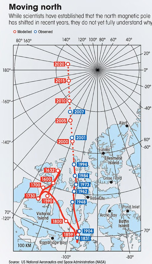
    • Pole Movement: Since 1831, the north magnetic pole has shifted 1,100 km toward Siberia and now moves at 35 km/year, while the south pole is more stable.

    Implications of Magnetic Flip-Flop:

    • Radiation Exposure: A weaker magnetic field during flip-flop allows more cosmic radiation, affecting:
      • Satellites and astronauts
      • Navigation and communication systems
      • Power grids and electronics
    • Protective Shield: Earth’s atmosphere still protects against harmful radiation even when the magnetic field is weak.
    • Climate & Ozone Effects: Events like Laschamps may have altered the ozone layer and climate, but no confirmed link to mass extinctions.
    • South Atlantic Anomaly: A current weak-field region affecting spacecraft over South America and South Africa.
    • Monitoring Tools: Scientists use satellites, ice cores, volcanic rocks, and geomagnetic observatories to track field changes.
    • Global Guidance: The World Magnetic Model, updated every 5 years, supports navigation systems worldwide.
    • Prediction Outlook: Though timing of future reversals is uncertain, computer models and cosmic data are improving forecasts.
    [UPSC 2017] Consider the following statements:

    1. The Earth’s magnetic field has reversed every few hundred thousand years.

    2. When the Earth was created more than 4000 million years ago, there was 54% oxygen and no carbon dioxide.

    3. When living organisms originated, they modified the early atmosphere of the Earth.

    Which of the statements given above is/are correct?

    Options: (a) 1 only (b) 2 and 3 only (c) 1 and 3 only * (d) 1, 2 and 3


  • World’s most powerful Solar Particle Storm struck Earth 14,300 years ago

    Why in the News?

    Scientists have discovered that a massive solar storm hit Earth around 12,350 BC, making it the most powerful solar event ever detected.

    What are Solar Particle Storms?

    • About: A solar storm is a disturbance caused by solar flares or coronal mass ejections that release charged particles into space.
    • Solar Particle Storm: It is a type of solar storm where high-energy particles travel toward Earth, producing cosmogenic isotopes like radiocarbon.
    • Detection: These isotope spikes are recorded in tree rings and are known as Miyake events, which act as cosmic timestamps.
    • Impact: Though rare, solar particle storms can severely affect satellites, communication systems, and power grids.
    • Historical Events: Major solar particle storms were identified in AD 994, 663 BC, 5259 BC, and 7176 BC.
    • Carrington Event (1859): This was a major solar storm, but not a particle storm—it resulted from a different solar mechanism.

    How was the ancient storm detected?

    • Methodology: A solar storm from 12,350 BC was discovered using tree-ring data from the French Alps.
    • Event Strength: This storm was over 500 times stronger than the 2005 solar storm, the largest in the satellite era.
    • What are its implications?
      • Significance: This is the first known extreme solar event before the Holocene, predating the last 12,000 years of stable climate.
      • Modern Relevance: The discovery highlights the risks of future extreme solar activity on Satellite infrastructure and Space Application.
      • Significance: Miyake events improve the precision of archaeological dating, helping better understand ancient human history.
    [UPSC 2022] If a major solar storm (solar flare) reaches the Earth, which of the following are the possible effects on the Earth?

    1. GPS and navigation systems could fail.

    2. Tsunamis could occur at equatorial regions.

    3. Power grids could be damaged.

    4.  Intense auroras could occur over much of the Earth.

    5. Forest fires could take place over much of the planet.

    6. Orbits of the satellites could be disturbed.

    7. Shortwave radio communication of the aircraft flying over polar regions could be interrupted.

    Select the correct answer using the code given below:

    Options: (a) 1 only (b) 2 and 3 only (c) 1 and 3 only (d) 1, 2, 3, 4, 6 and 7*

    Tap to know more about the answer.


  • Seasonal Impact of Monsoons on Wind Power

    Why in the News?

    The onset of cool, moisture-laden monsoon winds offers not just relief but also a significant opportunity for wind energy generation.

    About the Indian Monsoon:

    • Origin: The word “monsoon” comes from Arabic ‘mausin’ or Malayan ‘monsin,’ meaning “season”.
    • Seasonal Wind Shift: Monsoons are seasonal winds that reverse direction with changing seasons.
    • Types:
      1. Southwest Monsoon: Blows from sea to land, bringing rainfall across most of India.
      2. Northeast Monsoon: Blows from land to sea, bringing rain mainly to southeast India.
    • Role of Tibet: The Tibetan Plateau heats up in summer, creating low pressure that draws in moist winds.
    • Ocean Influence: A high-pressure system in the southern Indian Ocean helps drive the southwest monsoon.
    • Atmospheric Factors: Influencers include the Subtropical Jet Stream, Tropical Easterly Jet, and ITCZ.
    • Other Drivers: The Somali Jet, Somali Current, Indian Ocean Dipole, and Walker Cell also affect monsoon behaviour.

    How does monsoon impact wind variability?

    • Changing Wind Speeds: Monsoon wind speeds vary in strength and direction over time and place.
    • Energy Planning: Wind behaviour prediction is crucial for renewable power management, especially wind energy.
    • Agricultural Demand: Kharif crops planted in June depend on monsoon, raising seasonal energy demand.
    • Wind Energy Output: In areas like the Western Ghats, 70% of wind energy is generated June–September.
    • Forecasting Tools: Numerical Weather Prediction (NWP) models provide high-resolution wind forecasts.
    • AI Models: Tools like Google’s MetNet3 use satellite and radar data to predict wind in remote areas.

    India’s Wind Energy: Capacity, Growth & Challenges

    • India became the 3rd largest wind and solar producer in 2024, after China and the US.
    • Installed wind capacity: 50 GW as of March 31, 2025.
    • In 2024, wind and solar contributed 10% of electricity—solar 7%, wind 3%; hydro added 8%, totalling 22% from clean sources.
    • Solar capacity grew by 24 GW in 2024, doubling 2023’s figure; wind grew by 3.4 GW.
    • Leading wind additions: Gujarat (1,250 MW), Karnataka (1,135 MW), Tamil Nadu (980 MW).
    • Top wind states: Tamil Nadu, Gujarat, and Maharashtra; targets: 140 GW wind and 500 GW non-fossil capacity by 2030.
    • Land Use & Capacity Utilization Factor (CUF): Wind farms occupy just 2% of land, allowing agriculture on the rest; CUF ranges between 16%–19%, with peak generation during monsoon months.


    [UPSC 2014] The seasonal reversal of winds is the typical characteristic of:

    Options: (a) Equatorial climate (b) Mediterranean climate (c) Monsoon climate * (d) All of the above climates


  • Changing patterns of Western Disturbances

    Why in the News?

    Heavy rainfall and strong winds disrupted life in Delhi due to a fresh splash of Western Disturbances over North India.

    Changing patterns of Western Disturbances

    What are Western Disturbances?

    • Western Disturbances are extra-tropical weather systems that originate near the Mediterranean region.
    • They carry moisture from the Mediterranean Sea, Black Sea, Caspian Sea, and Arabian Sea.
    • These disturbances are embedded within the subtropical westerly jet stream, a fast-moving air current in the upper atmosphere.
    • They bring rain, snow, and fog, especially from December to March, as they encounter the Himalayas, causing rainfall in the plains and snowfall at higher altitudes.
    • They are responsible for most of the winter and pre-monsoon rainfall in Northwest India and are critical for rabi crops like wheat.

    Recent Changes in its Pattern:

    • Recent observations show an increase in frequency, particularly from late January onwards, with disturbances now occurring outside the winter season.
    • These disturbances have been observed even in May, June, and July, where they were once rare.
    • The geographic spread of these disturbances is widening, affecting larger parts of North and Northwest India.
    • Reasons behind:
      • The strengthening of the subtropical westerly jet stream, likely influenced by rising global temperatures, is a key factor.
      • The delayed retreat of the jet stream is affecting the timing of the summer monsoon, leading to overlapping weather patterns.
      • The warming of the Arabian Sea (by 1.2°C to 1.4°C over recent decades) is increasing moisture, intensifying rainfall.
    [UPSC 2015] Consider the following statements:

    1. The winds which blow between 30° N and 60° S latitudes throughout the year are known as westerlies. 2. The moist air masses that cause winter rains in North-Western region of India are part of westerlies.

    Which of the statements given above is/are correct?

    Options: (a) 1 only (b) 2 only * (c) Both 1 and 2 (d) Neither 1 nor 2