Mains Ready By December. Smash Mains & Smash PYQ Admissions Open

GS Paper: Salient Features Of World’S Physical Geography

  • India’s Arctic imperative

    Why in the news? 

    The Indian government appears interested in capitalizing on seabed mining and resource exploitation in the Arctic

    About Artice Region:

    • The Arctic region is rich in energy resources, including oil, natural gas, and renewable energy sources such as wind, solar, hydro, geothermal, and tidal power.
    • The Arctic covers an area of approximately 8 million square kilometers, with interests belonging to Denmark, Canada, Iceland, Finland, Russia, Norway, Sweden, and the United States

    The reason behind the growing interest in the Arctic Region:

    • Climate Change Concerns: India’s increased interest in the Arctic stems from scientific data revealing accelerated warming in the region.
    • Trade Route Opportunities: India seeks to capitalize on the opening up of Arctic sea routes, particularly the Northern Sea Route, to enhance its trade efficiency.
    • Geopolitical Considerations: India’s focus on the Arctic is also driven by geopolitical factors, including concerns over China’s expanding presence and Russia’s decisions regarding access to Arctic routes.
    • Historical Engagement: India’s involvement in the Arctic dates back to 1920 with the signing of the Svalbard Treaty.

    Indian Initiatives:

    • Arctic Council: As an Observer in the Arctic Council, India actively participates in various working groups and expert meetings. India’s involvement in these discussions helps in understanding Arctic governance issues and contributes to the development of sustainable policies for the region.
    • INS Himadri: In 2019, India launched its first scientific expedition to the Arctic with the INS Himadri, an ice-class research vessel. The expedition aimed to study climate change, oceanography, and marine biodiversity, furthering India’s expertise in polar research.
    • PAME: India’s commitment to sustainable development in the Arctic is reflected in its engagement with Arctic Council initiatives like the ‘Protection of the Arctic Marine Environment’ (PAME).

    Way Forward – Potential for Collaboration:

    • Green Energy and Clean Industries: India’s current policy emphasizes cooperation with Arctic countries, particularly Norway, in green energy and clean industries. This aligns with India’s goal of positioning itself as a responsible stakeholder in global environmental initiatives.
    • Transformational Partnership: Collaboration with Norway could be transformative for India, offering opportunities for increased participation in Arctic Council working groups
    • Scientific Research and Environmental Protection: A partnership with Norway is expected to focus on scientific research, climate, and environmental protection. These areas align with India’s Arctic Policy pillars, emphasizing the importance of addressing environmental challenges through research and cooperation.
  • Taiwan’s Earthquake and the Pacific Ring of Fire

    Why in the news?

    • Taiwan was struck by its most powerful earthquake in at least 25 years.
    • Its susceptibility to earthquakes is attributed to its location along the Pacific “Ring of Fire” where a majority of the world’s seismic activity occurs.
    • Taiwan is primarily influenced by the collision of the Philippine Sea Plate and the Eurasian Plate.

    What is the Pacific ‘Ring of Fire’?

    • The Pacific ‘Ring of Fire’ or Pacific Rim, or the Circum-Pacific Belt, is an area along the Pacific Ocean that is characterized by active volcanoes and frequent earthquakes.
    • Volcanic arcs and oceanic trenches partly encircling the Pacific Basin form the so-called Ring of Fire.
    • It is home to about 75 per cent of the world’s volcanoes – more than 450 volcanoes.
    • Also, about 90 per cent of the world’s earthquakes occur here.

    Its spread

    • Its length is over 40,000 kilometres and traces from New Zealand clockwise in an almost circular arc covering Tonga, Kermadec Islands, Indonesia.
    • It is moving up to the Philippines, Japan, and stretching eastward to the Aleutian Islands, then southward along the western coast of North America and South America.

    Seismic activity of the region

    • The area is along several tectonic plates including the Pacific plate, Philippine Plate, Juan de Fuca plate, Cocos plate, Nazca plate, and North American plate.
    • The movement of these plates or tectonic activity makes the area witness abundant earthquakes and tsunamis every year.
    • Along much of the Ring, tectonic plates move towards each other creating subduction zones.
    • One plate gets pushed down or is subducted by the other plate.
    • This is a very slow process – a movement of just one or two inches per year.
    • As this subduction happens, rocks melt, become magma and move to Earth’s surface and cause volcanic activity.

    PYQ:

    2020: Discuss the geophysical characteristics of Circum-Pacific Zone.

  • Subduction Zone discovered beneath Gibraltar Strait

    What is the news?

    • Scientists in Portugal have uncovered a concerning revelation about the fate of the Atlantic Ocean, highlighting a potential ‘Ring of Fire’ (a Subduction Zone).
    • Researchers caution that the Atlantic may be on the brink of closure due to subduction activity.

    Why discuss this?


    • Closure of Gibraltar Strait: Computer simulations project the subduction zone’s expansion over the next 20 million years, forming the ‘Ring of Fire’ in the Atlantic leading to the closure of Gibraltar Strait.
    • Geological Parallel: This process mirrors the Pacific Ocean’s Ring of Fire, reshaping the ocean basin through gradual subduction of the ocean floor beneath continents.


    About Gibraltar Strait

    Details
    Location
    • Connects the Atlantic Ocean to the Mediterranean Sea;
    • Separating the southern tip of the Iberian Peninsula of Europe from the northern coast of Africa.
    Width Approximately 13 km (8.1 miles) at its narrowest point.
    Depth Varies, with the deepest point reaching around 300 meters (984 feet).
    Formation
    • Convergence point for the Eurasian Plate and the African Plate.
    • Formed around 5.33 million years ago during the Messinian salinity crisis when the Atlantic Ocean breached the barrier separating it from the Mediterranean Sea, resulting in a catastrophic flood known as the Zanclean flood.
    • The strait’s current shape and depth were further influenced by tectonic movements and erosional processes over geological time.
    Historical Significance Serves as a key maritime passage for trade and military purposes.
    Disputes
    • Subject of contention between Spain and the United Kingdom;
    • Gibraltar Overseas Territory under British control.


    What are Subduction Zones?

    • Subduction zones occur at convergent plate boundaries, where two tectonic plates move toward each other.
    • This convergence is often between an oceanic plate and a continental plate or between two oceanic plates.
    • Subduction Process:
    1. Collision of Tectonic Plates: When two tectonic plates collide, the denser oceanic plate is forced beneath the less dense continental plate or another oceanic plate.
    2. Partial Melting: As the oceanic plate descends into the mantle, it generates intense heat and pressure, causing partial melting of the mantle material.
    3. Volcanic Activity: The molten material formed by the subduction process rises through the Earth’s crust, leading to volcanic eruptions at the surface.
    4. Formation of Volcanic Arcs: These eruptions often occur in chains known as volcanic arcs, which parallel the subduction zone. Ex. Andes in S. America; Cascade Range in North America.

    Implications of this Activity

    • Earthquakes: Subduction zone earthquakes can be particularly destructive and may trigger tsunamis due to the displacement of large volumes of water.
    • Trench Formation: The surface expression of a subduction zone is often a deep oceanic trench, where the descending plate bends and plunges into the mantle.
    • Mountain Building: Over time, the continuous subduction of oceanic crust can lead to the uplift and deformation of the overriding plate, resulting in the formation of mountain ranges adjacent to the subduction zone. These mountains may exhibit complex geological structures, including folds and faults.
    • Recycling of Oceanic Crust: As oceanic plates are subducted, they are gradually consumed by the mantle, releasing minerals and elements that are eventually returned to the surface through volcanic activity.

    PYQ:

    2010: Which one of the following can one come across if one travels through the Strait of Malacca?

    1. Bali
    2. Brunei
    3. Java
    4. Singapore


    2011: Between India and East Asia, the navigation time and distance can be greatly reduced by which of the following?

    1. Deepening the Malacca straits between Malaysia and Indonesia.
    2. Opening a new canal across the Kra Isthmus between the Gulf of Siam and Andaman sea.

    Which of the statements given above is/are correct?

    1. 1 only
    2. 2 only
    3. Both 1 and 2
    4. Neither 1 nor 2


    Practice MCQ:

    Which of the given statement about the Gibraltar Strait is NOT correct?

    1. It connects the Atlantic Ocean to the Mediterranean Sea.
    2. It is approximately 13 kilometers wide at its narrowest point.
    3. The deepest point of the Gibraltar Strait reaches around 300 meters.
    4. It was formed around 5.33 million years ago during the Holocene Epoch due to tectonic movements.
  • Scientists vote down Declaration of Anthropocene Epoch

    In the news

    • The proposal to declare the start of the Anthropocene Epoch, signifying the impact of human activity on Earth’s geological history, has sparked debate among scientists.
    • Despite mounting evidence of human-induced changes to the planet, a recent vote by a scientific committee has rejected the notion.

    Understanding Geological Time

    • Geologic Time Scale: Geoscientists use the Geologic Time Scale (GTS) to measure Earth’s history, categorizing it into aeons, eras, periods, epochs, and ages.
    • Chronostratigraphic Classification: The GTS is based on chronostratigraphic units, marked by significant geological events, shaping the planet’s conditions.

    The Proposed ‘Human Epoch’

    • Holocene Epoch: The Holocene began approximately 11,700 years ago, following the Last Glacial Period, coinciding with the rise of human civilization.
    • Anthropocene Proposal: The Anthropocene concept suggests that human activities have altered Earth significantly, warranting recognition as a distinct geological epoch.

    Understanding the Anthropocene Epoch

    • Coined Term: The Anthropocene epoch was first coined by Nobel Prize-winning chemist Paul Crutzen and biology professor Eugene Stoermer in 2000.
    • Human Impact: The Anthropocene represents the geological time interval characterized by radical changes in the Earth’s ecosystem due to human impact, particularly since the onset of the Industrial Revolution.
    • Environmental Changes: Numerous phenomena associated with the Anthropocene include global warming, sea-level rise, ocean acidification, mass-scale soil erosion, deadly heat waves, and environmental deterioration.
    • Geological Strata: The AWG’s website states that these changes are reflected in a distinctive body of geological strata, with the potential to be preserved into the far future.

    Rejection of the Proposal

    • Scientific Deliberations: Despite the Anthropocene Working Group’s proposal, the Subcommission on Quaternary Stratigraphy voted against declaring the Anthropocene epoch.
    • Criticism and Concerns: Critics argue against defining the Anthropocene based on recent events, questioning the significance of the proposed start date and the boundary between epochs.

    Geological Implications

    • Definition of Epochs: The rejection highlights the challenge of defining geological epochs based on human-induced changes, given the traditional criteria for epoch delineation.
    • Permanence and Recognition: While the vote does not negate human impact on the planet, it raises questions about the formal recognition of the Anthropocene as a distinct epoch.

    Future of the Anthropocene Concept

    • Beyond Epochs: Some scientists propose viewing the Anthropocene as an “event” rather than a formal epoch, acknowledging its transformative nature without conforming to traditional geological classifications.
    • Relevance and Recognition: Regardless of formal classification, the concept of the Anthropocene underscores the profound impact of human activity on Earth’s systems, shaping discussions on environmental stewardship and sustainability.

    Back2Basics: Geological Time Scale

    • The Geological Time Scale is a system used by geologists and palaeontologists to divide Earth’s history into distinct time intervals based on significant geological and biological events.
    • It provides a framework for organizing and understanding the vast expanse of time since the formation of the Earth, approximately 4.6 billion years ago, up to the present day.
    • The Scale is divided into several hierarchical units, including eons, eras, periods, epochs, and ages.

    Here is a simplified overview of the major divisions:

    (1) Eon: The largest division of time on the Geological Time Scale. The history of Earth is typically divided into four eons:

    • Hadean Eon: Represents the earliest stage of Earth’s history, from its formation to around 4 billion years ago.
    • Archean Eon: Covers the period from around 4 billion to 2.5 billion years ago. It includes the formation of the Earth’s crust, the emergence of life, and the development of the first continents.
    • Proterozoic Eon: Encompasses the time between 2.5 billion and 541 million years ago. It includes significant evolutionary developments, such as the emergence of complex multicellular life.
    • Phanerozoic Eon: The current eon, spanning from 541 million years ago to the present. It is further divided into eras.

    (2) Era: The second-largest division of time, encompassing longer periods of geological history within an eon. The Phanerozoic Eon is divided into three eras:

    • Paleozoic Era: Covers the time from 541 million to 252 million years ago. It is known for the diversification of life, including the appearance of complex marine organisms, fish, insects, and the first terrestrial plants.
    • Mesozoic Era: Spans from 252 million to 66 million years ago. It is often referred to as the “Age of Reptiles” and includes the dominance of dinosaurs, as well as the rise of mammals and birds.
    • Cenozoic Era: Extends from 66 million years ago to the present. It is sometimes called the “Age of Mammals” and includes the diversification and proliferation of mammals, the appearance of humans, and the development of modern ecosystems.

    (3) Period: A subdivision of an era, representing a distinct interval of time characterized by specific geological and biological events. For example:

    • The Paleozoic Era is divided into periods such as the Cambrian, Ordovician, Silurian, Devonian, Carboniferous, and Permian.
    • The Mesozoic Era is divided into periods including the Triassic, Jurassic, and Cretaceous.
    • The Cenozoic Era is divided into periods such as the Paleogene, Neogene, and Quaternary.

    (4) Epoch: A smaller subdivision of a period, representing a shorter interval of time. Epochs are defined by more localized geological and biological changes.

    (5) Age: The smallest division of time on the Geological Time Scale. Ages represent relatively brief periods, often defined by specific fossil or rock layers.

  • What is Humboldt’s Enigma and What does it mean for India?

    Humboldt’s Enigma

    Introduction

    • The question of where biodiversity is concentrated has intrigued explorers and naturalists for centuries. Humboldt has tried to answer this question.

    Humboldt’s Insights

    • Alexander von Humboldt: A polymath of the 18th century, Humboldt recorded diverse natural observations, proposing a relationship between temperature, altitude, humidity, and species distribution.
    • Mountain Exploration: During his exploration of South America, Humboldt studied plant distribution on mountains, noting variations with elevation.
    • Chimborazo Mountain: Humboldt used Chimborazo Mountain in Ecuador as an example, illustrating the concept of mountain diversity.

    What is Humboldt’s Enigma?

    • Sun’s Energy: Tropical areas receive more solar energy, fostering greater primary productivity and biodiversity due to the availability of ecological niches.
    • Mountain Exception: Mountains, despite being outside the tropics, have been an exception to the rule, posing Humboldt’s enigma.

    Biodiversity Drivers

    • Earth’s History, Geography, and Climate: These factors are the primary drivers of mountain diversity.
    • Geological Processes: Mountains serve as ‘cradles’ for new species due to geological processes like uplifts, creating new habitats.
    • Climatic Stability: Climatologically stable mountains act as ‘museums,’ preserving species over time.
    • Coastal Tropical Sky Islands: Examples like the Shola Sky Islands in the Western Ghats exhibit both cradle and museum characteristics.

    Eastern Himalaya: An Anomaly

    • Diversity Beyond Tropics: Eastern Himalaya boasts exceptional diversity, challenging the conventional tropical biodiversity paradigm.
    • Multiple Factors: Climate dissimilarity and geological heterogeneity contribute to high biodiversity.
    • Climate Variability: Different temperature and rainfall levels on the same mountain support diverse biomes.

    Unresolved Questions

    • Complexity of Biodiversity: Numerous factors drive diversification and Humboldt’s enigma in different regions, leading to over a hundred hypotheses.
    • Data Limitations: Fine-scale species occurrence data are lacking, hindering precise explanations.
    • Call for Research: India’s under-studied areas need more extensive research, including the use of genetics, to understand true biodiversity.
    • National Initiatives: Programs like the National Mission on Himalayan Studies and Biodiversity need strengthening to support basic research.

    Conclusion

    • Humboldt’s enigma represents one facet of mountain biodiversity, offering opportunities for study and insights into global climate and landscape change issues.
  • Earthquake and Tsunami strikes Central Japan

    japan

    Central Idea

    • On January 1, 2024, a 7.5-magnitude earthquake hit Ishikawa prefecture in Japan, triggering tsunami waves over a meter high.

    Japan’s Geographical Vulnerability

    • Japan’s geographical vulnerability, particularly concerning plate tectonics, is a critical aspect of its environmental and disaster management challenges.
    • The country’s location at the convergence of several major tectonic plates makes it highly susceptible to seismic activities.

    Here’s a detailed look at how plate tectonics contribute to Japan’s geographical vulnerability:

    [1] Convergent Plate Boundaries:

    • Pacific Ring of Fire: Japan is located on the Pacific Ring of Fire, an area with a high level of seismic activity due to the presence of numerous tectonic plate boundaries.
    • Plates Involved: The primary tectonic plates interacting near Japan are the Pacific Plate, the Philippine Sea Plate, the Eurasian Plate, and the North American Plate.
    • Subduction Zones: The Pacific and Philippine Sea plates are subducting beneath the Eurasian and North American plates. This subduction process is a significant source of seismic activity, including powerful earthquakes and volcanic eruptions.

    [2] Earthquake Activity:

    • Frequent Earthquakes: The movement of these plates results in frequent earthquakes. Japan experiences thousands of tremors annually, ranging from minor to catastrophic.
    • Major Earthquakes: Historical events like the 2011 Great East Japan Earthquake and the 1995 Great Hanshin Earthquake demonstrate the potential for massive destruction and loss of life due to Japan’s tectonic setting.

    [3] Tsunami Risk:

    • Generation of Tsunamis: Earthquakes occurring under the sea or along the coast can displace large volumes of water, leading to tsunamis. The 2011 tsunami, triggered by a massive undersea earthquake, caused widespread devastation and the Fukushima nuclear disaster.
    • Coastal Impact: Japan’s extensive coastline makes it particularly vulnerable to tsunamis, which can arrive within minutes of an undersea earthquake, leaving little time for evacuation.

    [4] Volcanic Activity:

    • Volcanic Eruptions: The subduction of the Pacific and Philippine Sea plates not only causes earthquakes but also contributes to significant volcanic activity. Magma generated by the melting of the subducted plate rises to the surface, leading to volcanic eruptions.
    • Active Volcanoes: Japan has over 100 active volcanoes, a direct result of its tectonic setting. Eruptions pose risks to nearby populations and can disrupt air travel and local economies.

    [5] Geological Complexity:

    • Intersecting Faults: The interaction of multiple tectonic plates creates a complex network of faults, increasing the unpredictability and variability of seismic events.
    • Diverse Seismic Phenomena: This complexity leads to a range of seismic phenomena, including deep-focus earthquakes, which occur at greater depths and can affect broader areas.
  • The Atlantic Niño’s role in India’s erratic monsoon

    Context

    Last month, farmers from Madhya Pradesh threatened to take IMD to court for the inaccurate monsoon forecast this year. A question was also raised in Parliament about whether the Arctic warming had led to an erratic monsoon this year.

    Understanding the role of Atlantic Niño in monsoon prediction

    • Monsoon predictions are a monumental challenge, especially when it comes to the spatial distribution and the northward migration of the monsoon trough.
    • Forecast models tend to rely heavily on El Niño for monsoon predictions.
    • But only about 50 per cent of the dry years are explained by El Niño.
    • Clearly, Atlantic Niño is a significant player in monsoon evolution and models and forecasters must pay attention to this Atlantic teleconnection.
    • Atlantic Niño is El Niño’s little cousin in the Atlantic, also known as the Atlantic Zonal Mode.
    • Indian scientists from INCOIS have argued that the Atlantic Niño is in fact predictable up to three months in advance.
    • Every few years, from June to August, there is a warming in the eastern equatorial Atlantic, which does not get as much attention as its big brother El Niño.
    • The biggest rainfall deficits from the Atlantic Niño tend to occur over the Western Ghats and the core monsoon zone.

    How Atlantic Niño plays a role if Indian and Atlantic Oceans are not connected?

    • The Atlantic and Indian Oceans are not directly connected in the tropics via the ocean.
    • The Atlantic Niño affects the monsoon by producing atmospheric waves, which propagate into the Indian Ocean.
    • These waves affect air temperatures over the Indian Ocean and influence the land-ocean thermal contrast as well as Low Pressure Systems (LPS).

    Way forward

    • Overall, monsoon prediction skill has gone up in the IMD but even a 70 per cent accuracy means the forecasts will be wrong 30 per cent of the time.
    • Many of the Atlantic Niños occur during non-El Niño years and this offers a window of opportunity to increase forecast skills based on the accurate prediction of the Atlantic Niño.

    Conclusion

    No forecasts will ever be 100 per cent accurate. Climate scientists are also aware of the monsoon prediction challenge and they will continue to try to improve monsoon forecasts.

    UPSC 2022 countdown has begun! Get your personal guidance plan now! (Click here)


    Back2Basics:  El Niño and La Niña

    • These periodic weather patterns occur as a result of fluctuating ocean temperatures in one part of the world, namely the east-central equatorial Pacific Ocean.
    • This can lead to extreme weather.
    • When warm water builds up along the central and eastern tropical Pacific Ocean, an El Niño occurs.
    • Conversely, when cool water builds up along the same region, a La Niña occurs with the opposite impact.
  • What are Western Disturbances?

    With the approaching winter, minimum temperatures in the national capital have trended downward over the last due to the arrival of northwesterly winds called Western Disturbances.

    Try this PYQ:

    Q.Westerlies in the southern hemisphere is stronger and persistent than in northern hemisphere. Why?

    1. The southern hemisphere has less landmass as compared to the northern hemisphere.
    2. Coriolis force is higher in the southern hemisphere as compared to the northern hemisphere

    Which of the statements given above is/are correct?

    (a) Only 1

    (b) Only 2

    (c) Both 1 and 2

    (d) Neither 1 nor 2

    Western Disturbances

    • A western disturbance is an extratropical storm originating in the Mediterranean region that brings sudden winter rain to the northwestern parts of the Indian subcontinent.
    • It is a non-monsoonal precipitation pattern driven by the westerlies.
    • The moisture in these storms usually originates over the Mediterranean Sea, the Caspian Sea and the Black Sea.
    • Extratropical storms are global phenomena with moisture usually carried in the upper atmosphere, unlike their tropical counterparts where the moisture is carried in the lower atmosphere.
    • In the case of the Indian subcontinent, moisture is sometimes shed as rain when the storm system encounters the Himalayas.
    • Western disturbances are more frequent and strong in the winter season.

    Their significance

    • Western disturbances, specifically the ones in winter, bring moderate to heavy rain in low-lying areas and heavy snow to mountainous areas of the Indian Subcontinent.
    • They are the cause of most winter and pre-monsoon season rainfall across northwest India.
    • Precipitation during the winter season has great importance in agriculture, particularly for the rabi crops.
    • Wheat among them is one of the most important crops, which helps to meet India’s food security. An average of four to five western disturbances forms during the winter season.
    • The rainfall distribution and amount vary with every western disturbance.

    Also read: Polar Vortex 

  • Explained: Cycle 25/ Solar Cycle


    The sunspots identified by researchers from IISER Kolkata herald the start of a new solar cycle called Cycle 25.

    What are Sunspots?

    • Sunspots are temporary phenomena on the Sun’s photosphere that appear as spots darker than the surrounding areas. They are relatively cooler spots on the Sun’s surface.
    • They are regions of reduced surface temperature caused by concentrations of magnetic field flux that inhibit convection.
    • Sunspots usually appear in pairs of opposite magnetic polarity with a leader and a follower.

    What is Solar Cycle?

    • From our safe distance of about 148 million km, the Sun appears to be sedate and constant. However, huge solar flares and coronal mass ejections spew material from its surface into outer space.
    • They originate from sunspots, an important phenomenon that people have been following for hundreds of years. They originate deep within the Sun and become visible when they pop out.
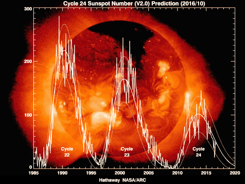
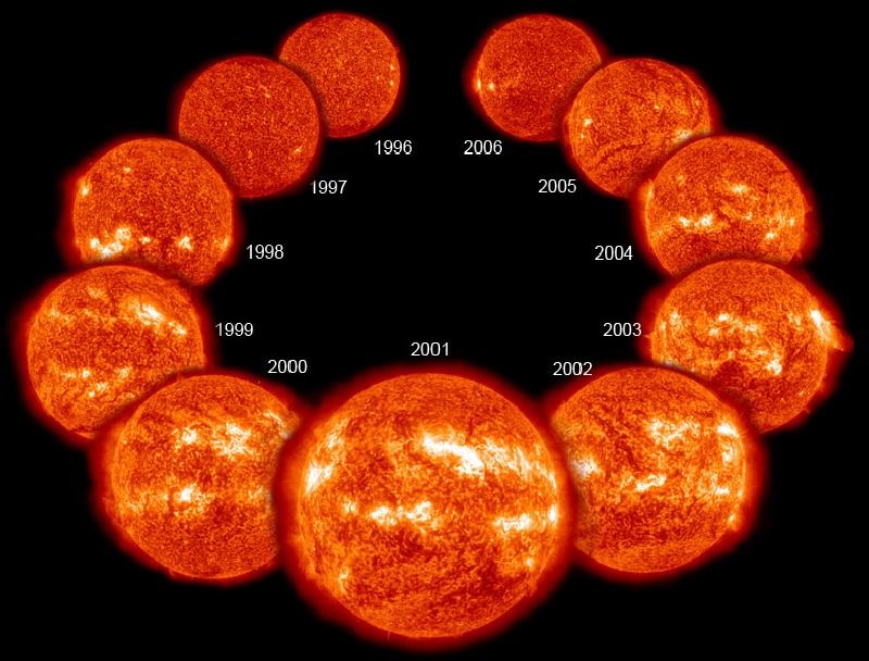
    • Their number is not constant but shows a minimum and then rises up to a maximum and then falls again in what is called the solar cycle.
    • Every 11 years or so, the Sun’s magnetic field completely flips. This means that the Sun’s north and south poles switch places. Then it takes about another 11 years for the Sun’s north and south poles to flip back again.
    • So far, astronomers have documented 24 such cycles, the last one ended in 2019.

    How do they occur?

    • Given the high temperatures in the Sun, matter exists there in the form of plasma, where the electrons are stripped away from the nuclei.
    • The Sun is made of hot ionized plasma whose motions generate magnetic fields in the solar interior by harnessing the energy of the plasma flows.
    • This mechanism is known as the solar dynamo mechanism (or magnetohydrodynamic dynamo mechanism).
    • Simply stated, it is a process by which kinetic energy of plasma motions is converted to magnetic energy, which generates the magnetised sunspots, giving rise to the solar cycle..
    • Because of the nature of the solar dynamo, the part of its magnetic field that gives rise to sunspots reverses direction when it moves from one solar cycle to another.
    • This can be inferred by observing when the relative orientation of the sunspot pairs flips.

    Features

    • The solar cycle affects activity on the surface of the Sun, such as sunspots which are caused by the Sun’s magnetic fields. As the magnetic fields change, so does the amount of activity on the Sun’s surface.
    • One way to track the solar cycle is by counting the number of sunspots.
    • The beginning of a solar cycle is a solar minimum, or when the Sun has the least sunspots. Over time, solar activity—and the number of sunspots—increases.
    • The middle of the solar cycle is the solar maximum, or when the Sun has the most sunspots. As the cycle ends, it fades back to the solar minimum and then a new cycle begins.
    • Giant eruptions on the Sun, such as solar flares and coronal mass ejections, also increase during the solar cycle. These eruptions send powerful bursts of energy and material into space.

    Impacts of Solar Cycle

    • This activity has effects on Earth. For example, eruptions can cause lights in the sky, called aurora, or impact radio communications. Extreme eruptions can even affect electricity grids on Earth.
    • Solar activity can affect satellite electronics and limit their lifetime.
    • Radiation can be dangerous for astronauts who do work on the outside of the International Space Station.
    • Forecasting of the solar cycle can help scientists protect our radio communications on Earth, and help keep satellites and astronauts safe.

    Start of cycle 25

    • Following a weakening trend in activity over the last few cycles, there were predictions that the Sun would go silent into a grand minimum in activity, with the disappearance of cycles.
    • However, a team from IISER Kolkata has shown that there are signs that cycle 25 has just begun.
    • They used the data from the instrument Helioseismic and Magnetic Imager aboard NASA’s space-based Solar Dynamics Observatory for their calculations.

    Why is this so important to us on earth?

    • After all the sunspots look small and are hardly even visible to us. Contrary to this, sunspot activity may be correlated with climate on earth.
    • In the period between 1645 and 1715, sun spot activity had come to a halt on the Sun – a phenomenon referred to as the Maunder minimum.
    • This coincided with extremely cold weather globally. So sunspots may have a relevance to climate on earth.
    • Such links are tenuous, but definitely solar activity affects space weather, which can have an impact on space-based satellites, GPS, power grids and so on.