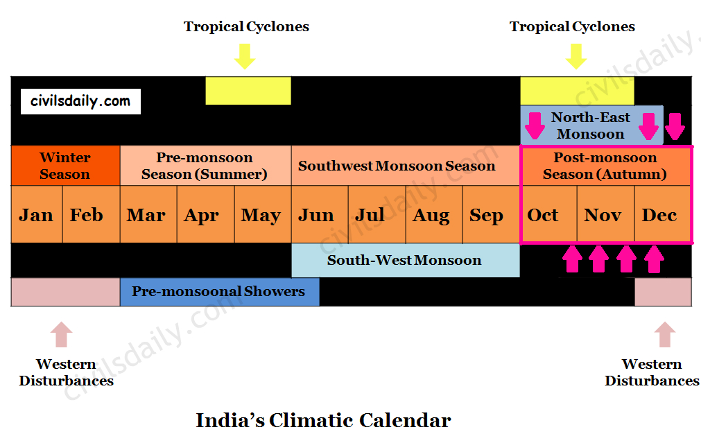
The months of October-November form a period of transition from the hot rainy season to the dry winter conditions.
The withdrawal of the south-west monsoon and the onset of north-east monsoon are both gradual phenomenon. They take place almost at the same time and tend to merge. This explains the popularity of the phrase “Retreating Monsoon”.
A Season of Retreating Monsoon
The retreat takes place due to the weakening of the low-pressure area over the north-western parts of India (and thus a gradual transition of ITCZ towards the south). This happens due to:
- The apparent shift of sun towards the equator
- Reduction in temperature due to widespread rains.
Consequently, the air pressure starts decreasing. Such changes in the atmospheric pressure cause the south-west monsoons to withdraw.
The Retreat of Monsoons is a process much slower than its arrival. It does not imply a right about turn but a gradual change of comparative pressure positions, thus gradually weakening and reducing the area of coverage and influence.
The retreat:
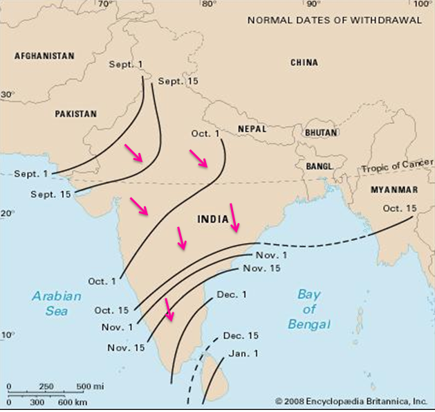
The south-west monsoons start retreating in the first week of September from Pakistan’s border in North-West India. Thus these winds withdraw earlier from the regions they reached the last.
The monsoon retreats from the western Rajasthan by the first week of September. It withdraws from Rajasthan, Gujarat, Western Ganga plain and the Central Highlands by the end of the month. By the beginning of October, the low pressure covers northern parts of the Bay of Bengal and by early November, it moves over Karnataka and Tamil Nadu. By the middle of December, the centre of low pressure is completely removed from the Peninsula.
Source
Temperature Conditions during this season:
- This season is marked by clear skies and a rise in temperature. The land is still moist. Owing to the conditions of high temperatures (around 25°C) and humidity, the weather becomes rather oppressive and unbearable. This is commonly known as the ‘October heat’ or ‘Kwar ki Umas’.
- In the second half of October, the mercury begins to fall rapidly, particularly in northern India. This continuous decrease in temperature after mid-October helps winter to set in by November or Early December.
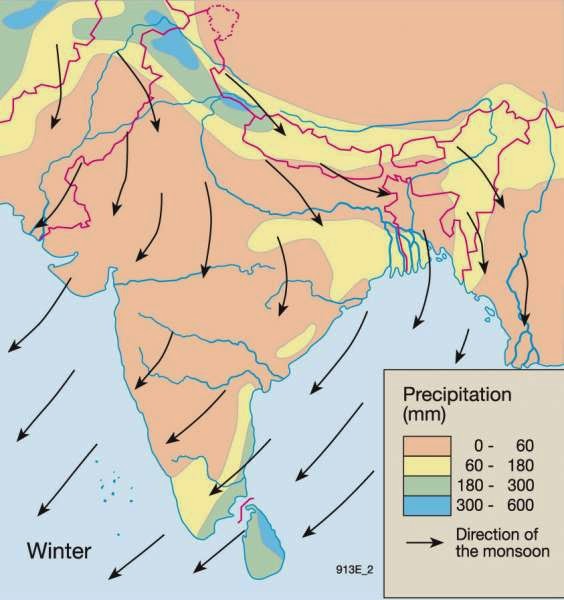
Surface Winds and Precipitation:
- By and large, the topography of the region influences the wind direction:
- The winds are westerly or northwesterly down the Ganga Valley.
- They become northerly in the Ganga-Brahmaputra delta.
- Free from the influence of topography, they are clearly north-easterly over the Bay of Bengal (thus the name North-East monsoon).
- Precipitation:
- Winter monsoons do not cause rainfall as they move from land to the sea. It is because:
- They have little humidity; and
- Due to anti-cyclonic circulation on land, the possibility of rainfall from them reduces.
- However, there are some exceptions:
- These months are the rainiest months of the year in coastal areas of Tamil Nadu. This is because the large indentation made by the Bay of Bengal into India’s eastern coast means that the flows are humidified before reaching Cape Comorin and rest of Tamil Nadu. Parts of West Bengal, Orissa, Andhra Pradesh, Karnataka and North-East India also receive minor precipitation from the northeast monsoons.
- Central parts of India and northern parts of southern Peninsula also get winter rainfall occasionally.
- Arunachal Pradesh and Assam in the northeastern parts of India also have rains between 25 mm and 50 mm during these winter months.
- Winter monsoons do not cause rainfall as they move from land to the sea. It is because:
Source
Tropical Cyclones:
- The low-pressure area lying over north-west India is transferred to the middle of Bay of Bengal by the end of October. As a result of these unstable conditions, severe cyclonic storms originate in this region.
- These cyclonic storms strike along the eastern coast of India causing widespread rain in the coastal regions.
- These tropical cyclones are very destructive. The thickly populated deltas of the Godavari, Krishna and Kaveri are their preferred targets. Every year cyclones bring disaster here. A few cyclonic storms also strike the coast of West Bengal, Bangladesh and Myanmar.
- A bulk of the rainfall of the Coromondal coast is derived from these depressions and cyclones. Such cyclonic storms are less frequent in the Arabian Sea.
Now that we have studied all the seasons in detail, let’s have a look at the annual distribution and variability of rainfall in India:
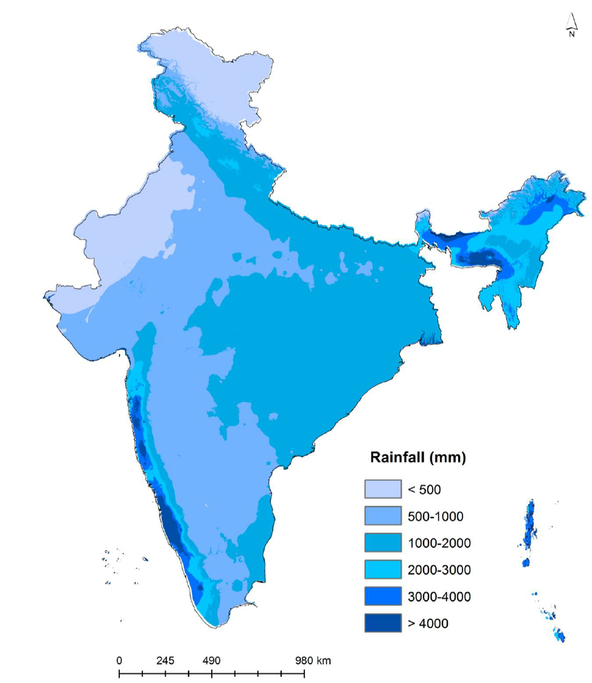
Rainfall Distribution:
The distribution of rainfall in India is highly uneven. Its distribution is largely controlled by the nearness of the sea and orographic features. The average annual rainfall in India is shown in the following map. Notice that the regional variations in the distribution of rainfall over India are quite pronounced.
Source
Variability:
The rainfall in India is highly variable. The actual rainfall of a place in a year deviates from the average rainfall by 10-60%.The variability of rainfall is computed with the help of the following formula:
The variability of rainfall is computed with the help of the following formula:
C.V. = (Standard Deviation÷ Mean) × 100
where C.V. is the coefficient of variation.
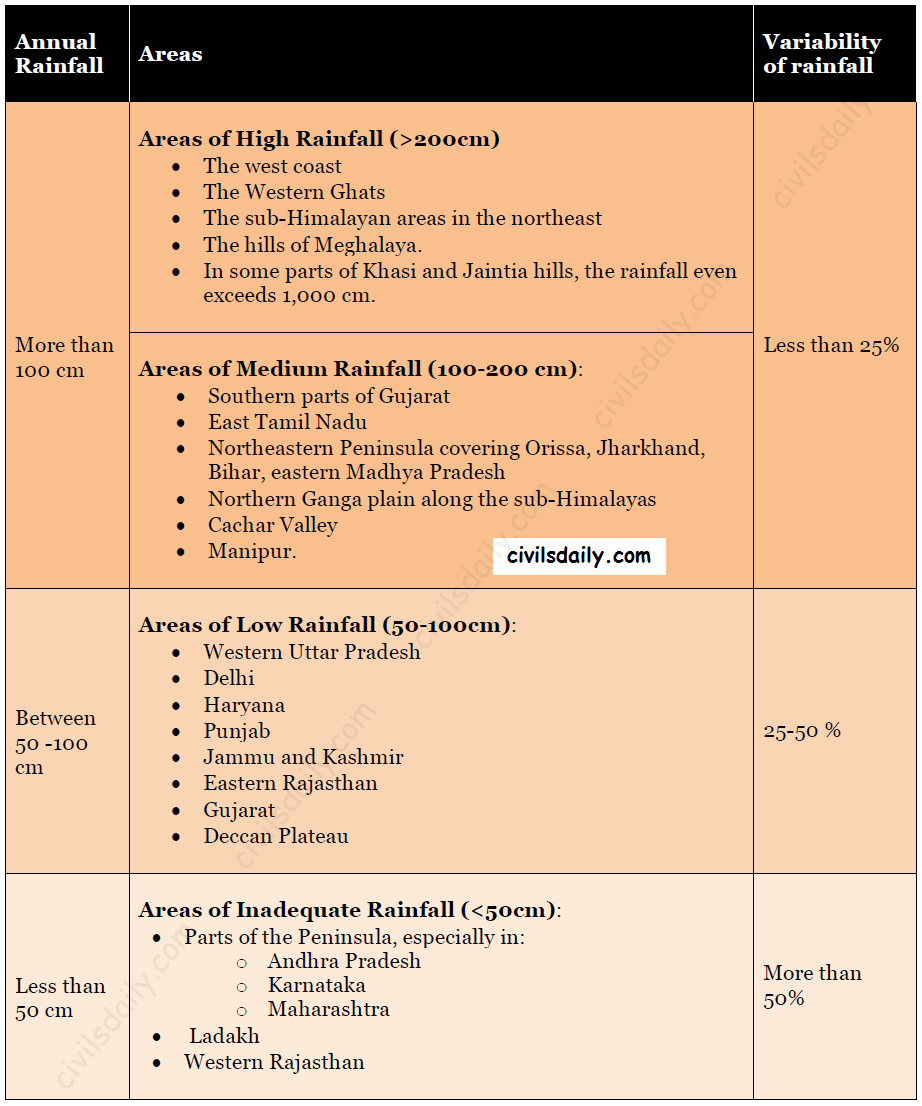
Notice that the regions of inadequate rainfall are also the regions with the highest variability of rainfall. The variability of rainfall has a significant role in the agricultural operations and other economic activities of a country. The areas showing high variability of rainfall have a chronic deficiency of water.
Climatic Regions of India
As discussed in the beginning, India has a monsoon type of climate with many regional variations. These variations represent the subtypes of the monsoon climate. It is on this basis that the climatic regions can be identified.
A climatic region has a homogeneous climatic condition which is the result of a combination of factors. Temperature and rainfall are two important elements which are considered to be decisive in all the schemes of climatic classification.
The classification of climate, however, is a complex exercise. There are different schemes of classification of climate. Two important ones are discussed here:
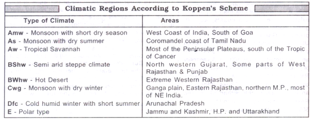
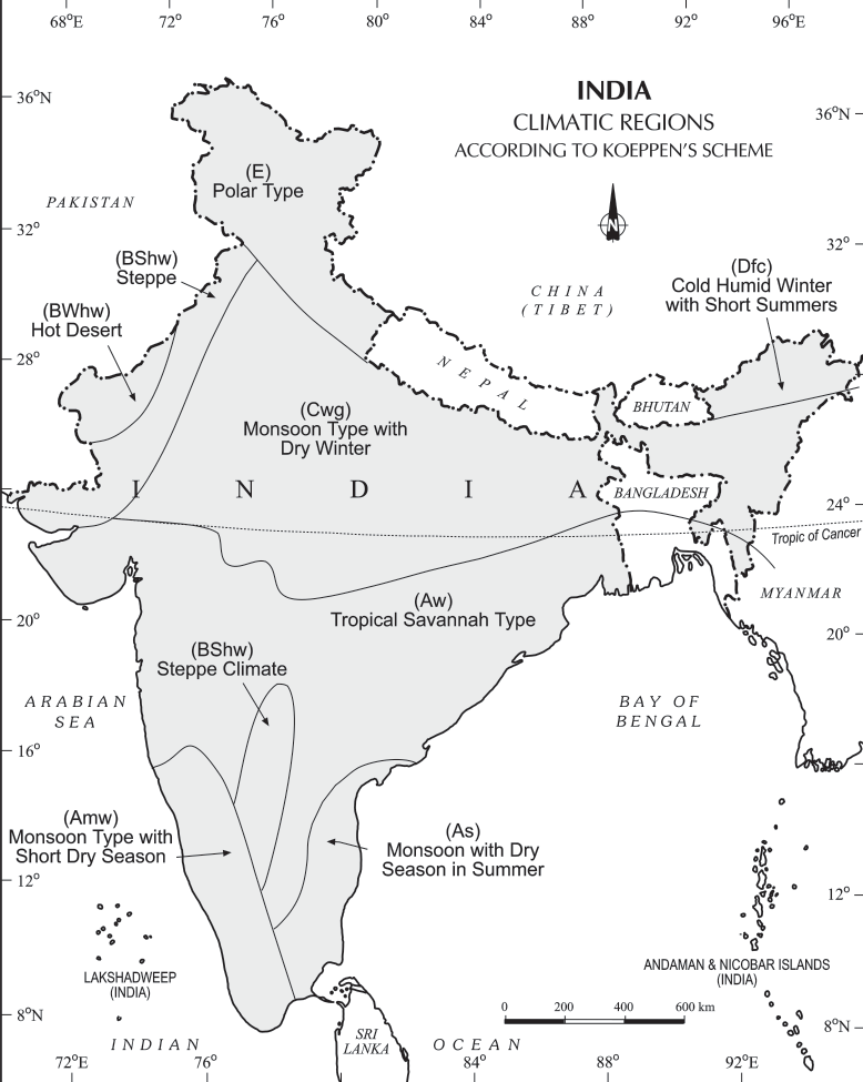
A) Koeppen’s scheme of Climatic classification
It is based on monthly values of temperature and precipitation.
He identified five major climatic types and used letter symbols A, B, C, D and E to denote them:
- Tropical climates (A): [where mean monthly temperature throughout the year >18°C]
- Dry climates (B): where precipitation is very low in comparison to temperature.
- If dryness is less, it is semiarid (S);
- If it is more, the climate is arid(W).
- Warm temperate climates (C): where mean temperature of the coldest month is between 18°C and minus 3°C.
- Cool temperate climates (D): where mean temperature of the warmest month is over 10°C, and mean temperature of the coldest month is under minus 3°C.
- Ice climates (E), where mean temperature of the warmest month is under 10°C.
These five types can be further subdivided into sub-types on the basis of seasonal variations in the distribution pattern of rainfall and temperature. Koppen used small letters such as m, w or h to define these sub-types:
f (sufficient precipitation)
m (rain forest despite a dry monsoon season),
w (dry season in winter)
h (dry and hot)
c (less than four months with mean temperature over 10°C)
g (Gangetic plain)
Accordingly, India can be divided into the following eight climatic regions:
Source
Source
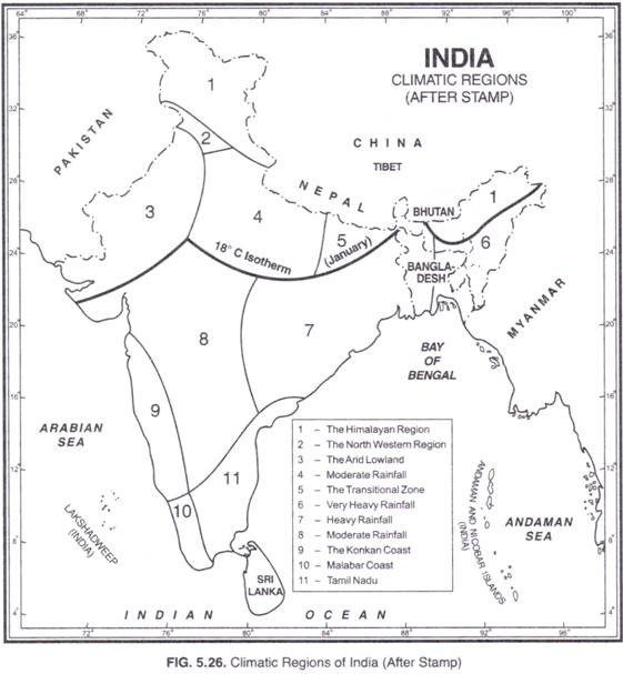
B) Climatic Divisions by Stamp and Kendrew:
Kendrew and Stamp on the basis of the 18°C isotherm for the month of January (which almost follows the Tropic of Cancer) divided India into two major climatic regions:
- Subtropical India (Continental)
- Tropical
These two major climatic regions have been further divided into eleven regions as follows:
- Subtropical India (Continental)
- The Himalayan region (heavy rainfall)
- The north-western region (moderate rainfall)
- The arid low land (dry plains)
- The region of moderate rainfall
- The transitional zone
- Tropical India
- Region of very heavy rainfall
- Region of heavy rainfall
- Region of moderate rainfall
- The Konkan Coast
- The Malabar Coast
- Tamil Nadu