Mains Ready By December. Smash Mains & Smash PYQ Admissions Open

Category: Ranker Webinars

  • The Winter Season (January – February)

    India’s Climatic Calendar – the Winter Season

    Temperature Conditions during this season:

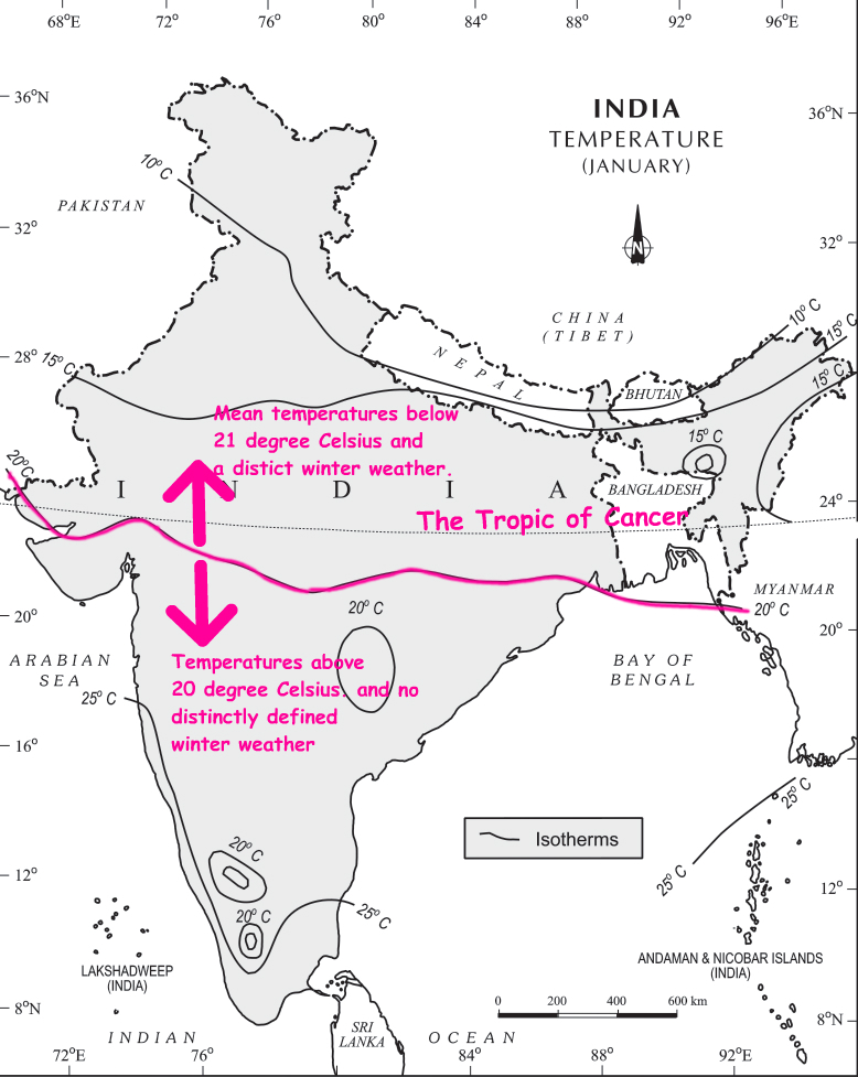
    By the end of December (22nd December), the sun shines vertically over the Tropic of Capricorn in the southern hemisphere. So, India which is located in the northern hemisphere experiences low temperatures. January and February are the coldest months over most parts of the country.
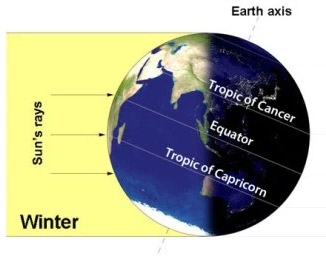
    Image Source

    The isotherm of 20°C runs roughly parallel to the Tropic of Cancer.
    The northern region:

    This season usually begins in late-November in northern India. Lowest temperatures are observed in Punjab and Rajasthan. December and January are the coldest months in the northern plain. The night temperature may be quite low, sometimes going below freezing point in Punjab and Rajasthan.

    There are three main reasons for the excessive cold in north India during this season:

    • States like Punjab, Haryana and Rajasthan being far away from the moderating influence of sea experience continental climate.
    • The snowfall in the nearby Himalayan ranges creates cold wave situation; and
    • Around February, the cold winds coming from the Caspian Sea and Turkmenistan bring cold wave along with frost and fog over the northwestern parts of India.

    The peninsular region:

    The Peninsular region of India, however, does not have any well-defined cold weather season. There is hardly any seasonal change in the distribution pattern of the temperature in coastal areas because of:

    • Moderating influence of the sea, and
    • Proximity to the equator.

    Distribution of air pressure and winds on the surface of the earth:

    In winter months, the weather conditions over India are generally influenced by the distribution of pressure in the Central and Western Asia.

    • A high-pressure centre in the region lying to the north of the Himalayas develops during winter.
    • This centre of high pressure gives rise to the flow of air from the north towards the Indian subcontinent, south of the mountain range.
    • These surface winds blowing out of the high-pressure centre over Central Asia reach India in the form of a dry continental air mass.
    • These continental winds come in contact with trade winds over northwestern India. The position of this contact zone is not, however, stable. Occasionally, it may shift its position as far east as the middle Ganga valley with the result that the whole of the northwestern and northern India up to the middle Ganga valley comes under the influence of dry northwestern winds.
    • In south India, the air pressure is slightly lower (due to higher temperatures). As a result, winds start blowing from northwestern high-pressure zone to the low air pressure zone over the Indian Ocean in the south. Due to a low pressure gradient, the light winds blow outwards with a low velocity of about 3-5 km per hour.
    • By and large, the topography of the region influences the wind direction (See the following map):
      • They are westerly or northwesterly down the Ganga Valley.
      • They become northerly in the Ganga-Brahmaputra delta.
      • Free from the influence of topography, they are clearly north-easterly over the Bay of Bengal.
    • These land bearing winds being cold and dry don’t give rain over most parts of the country. However, these winds cause rain along the Coromandel Coast since they collect moisture on their way over the Bay of Bengal.
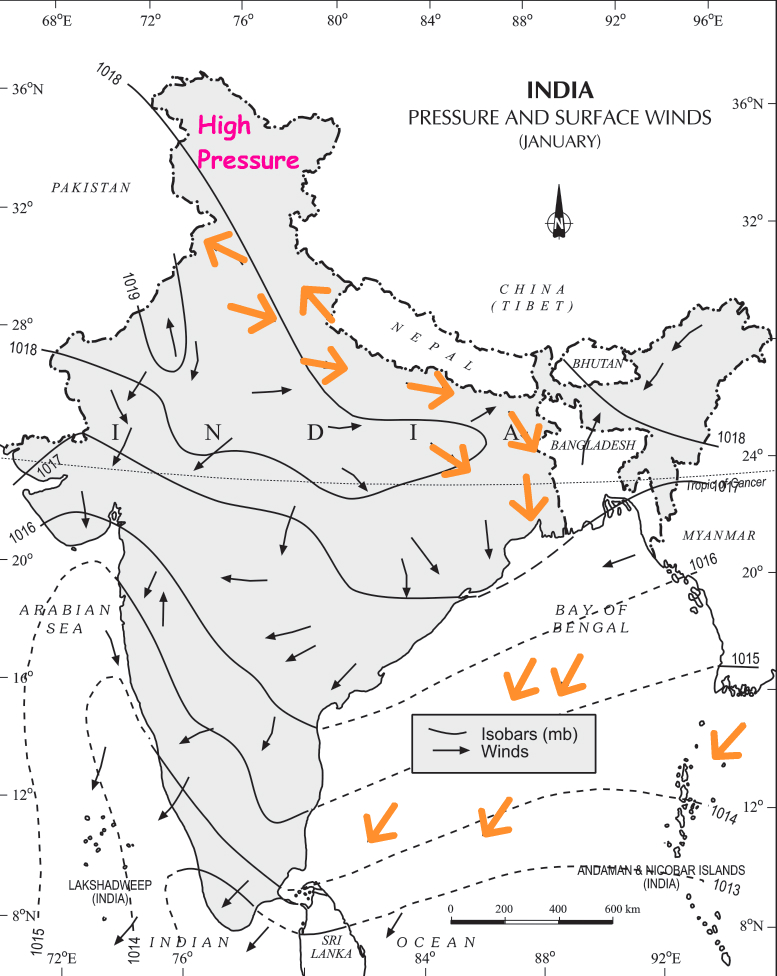
      Image Source – NCERT ClassXI

    Jet Stream and Upper Air Circulation:

    Higher up in the atmosphere, a different pattern of air circulation is observed during the winter months:

    • All of Western and Central Asia remains under the influence of westerly winds along the altitude of 9-13 km from west to east. These winds blow across the Asian continent at latitudes north of the Himalayas roughly parallel to the Tibetan highlands. These are known as the sub-tropical/tropical westerly jet stream.
    • Tibetan highlands act as a barrier in the path of these jet streams. As a result, jet streams get bifurcated. One of its branches blows to the north of the Tibetan highlands, while the southern branch blows in an eastward direction, south of the Himalayas, later recombining into a single stream over China.
    • It is believed that this southern branch of the jet stream exercises an important influence on the winter weather in India.
    • The mean position of this jetstream is about 25°N.
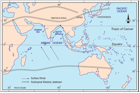
    Image Source: NCERT Class 9
    • This jetstream first appears over the northern parts of the Indian subcontinent in the month of October after the withdrawal of the summer monsoon and shifts progressively southwards with the advance of the winter season. Thereafter, it shifts back towards the north, weakens and disappears from the South Asian region with the establishment of the South-West monsoon in June. According to Dr.Koteshwaram, the disappearance of this jet from the south of the Himalayas paves the way for the burst of South-West Monsoon along the coast of Kerala.
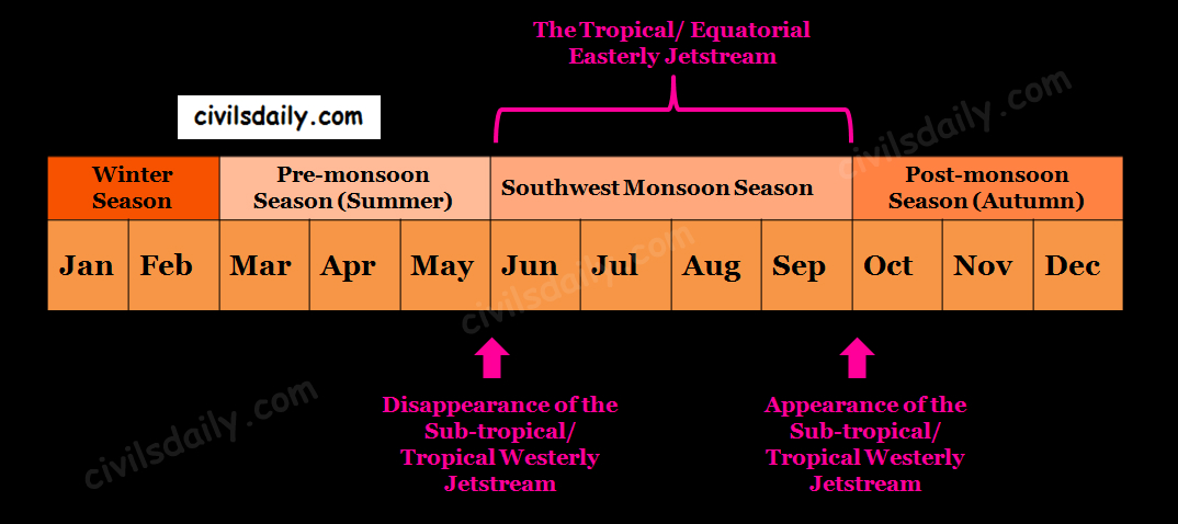
    Indian Climate and the role of Jetstreams.

    Western Disturbances:

    During the winters, the weather in India is pleasant. The pleasant weather conditions, however, at intervals, get disturbed by shallow cyclonic depressions originating over the east Mediterranean Sea.

    • These temperate cyclones travel eastwards across West Asia, Iran, Afghanistan and Pakistan and enter the north-western parts of India with the help of the westerly jetstream (discussed above).
    • On their way, the moisture content gets augmented from the Caspian Sea in the north and the Persian Gulf in the south. Since these extratropical cyclones reach India from the West, they are usually referred to as the western disturbances over the Indian region.
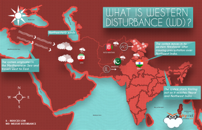
    Image Source

    • Because of the high terrain, mountain ranges, most of these disturbances are in the mature stage and hence weak or irregular by the time they reach India.
    • Reaching Rajasthan, Haryana and Punjab, these disturbances slow down and stagnate due the nearly closed in nature of the region with high hills.
    • With moisture feed from the Arabian Sea, these disturbances may intensify and move north-east. The tracks of these disturbances come farthest south to latitudes 22/23°N in the month of February.
    • An increase in the prevailing night temperature generally indicates an advance in the arrival of these disturbances.

    The western disturbances result in:

    • A cold spell in north-western India as these depressions are followed by cold waves.
    • Winter rainfall in Punjab, Haryana, Delhi and western Uttar Pradesh, locally known as ‘mahawat’. Although the amount is meagre, it is highly beneficial for Rabi crops.
    • Snowfall in the higher altitudes of Kashmir and Himachal Pradesh and sometimes hail too. It is this snow that sustains the flow of water in the Himalayan rivers during the summer months.

    The precipitation goes on decreasing from west to east in the plains and from north to south in the mountains.

    Note: The term western disturbance is generally applied to all disturbances which come from the West, even when a “low” may not be seen on the synoptic charts.
  • Indian Climate – An Introduction

    India’s climate can be described as hot monsoonal type. The word monsoon comes from the Arabic word ‘Mausim’ which means ‘season’. Monsoon, by definition, is a wind system that changes wind direction seasonally. The four principal monsoon regions in the world are:
    • South Asia
    • East Asia
    • Northern Australia
    • West Africa

    Let’s take the case of South Asia:

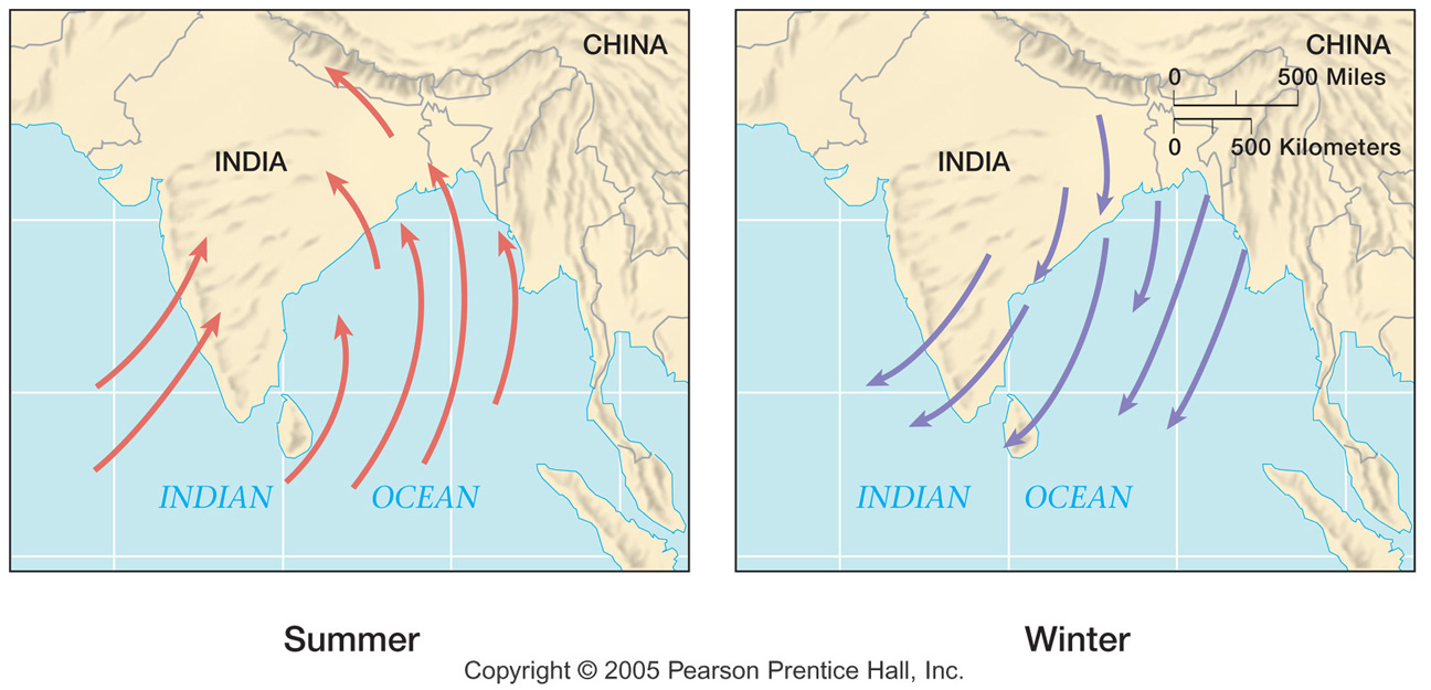
    During winter, the large continent of Asia gets extremely cold and the Siberian high pressure develops. Air flow is offshore and dry. During the summer, the continent develops low pressure in response to heating and the airflow reverses. Moisture-laden air from the ocean is brought inland where it rises over the terrain and produces extremely large amounts of rainfall. See the following diagram and observed the marked shift in the wind direction.

    Image Source

    But at the same time, we know that there are great regional differences and variations experienced in India with respect to temperature rainfall etc. Let’s look at some of these regional variations:

    • Variations in temperature: While in the summer the mercury occasionally touches 55°C in the western Rajasthan, it drops down to as low as minus 45°C in winter around Leh. On a December night, the temperature in Drass (Jammu and Kashmir) may drop down to minus 45°C while Thiruvananthapuram or Chennai on the same night record 20°C or 22°C.
    • Daily temperature range: In Kerala and in the Andaman Islands, the difference between day and night temperatures may be hardly seven or eight degree Celsius. But in the Thar desert, if the day temperature is around 50°C, at night, it may drop down considerably up to 15°-20°C.
    • Regional variations in type and amount of precipitation: While snowfall occurs in the Himalayas, it only rains over the rest of the country. Similarly, while Cherrapunji and Mawsynram in the Khasi Hills of Meghalaya receive rainfall over 1,080 cm in a year, Jaisalmer in Rajasthan rarely gets more than 9 cm of rainfall during the same period. Most parts of the country get rainfall during June-September, but in the coastal areas of Tamil Nadu, it rains in the beginning of the winter season.

    These regional variations differentiate the weather and climate of different regions of India.

    This brings us to the difference between weather and climate:

    Weather is the momentary state of the atmosphere while climate refers to the average of the weather conditions over a longer period of time. Weather changes quickly, maybe within a day or week but climate changes imperceptively and may be noted after 50 years or even more.

    Factors Determining the Climate of India:


    India’s climate is controlled by a number of factors which can be broadly divided into two groups — factors related to location and relief, and factors related to air pressure and winds.

    Factors related to Location and Relief

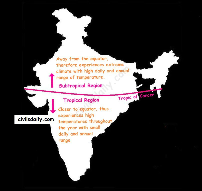
    1. Latitude: The Tropic of Cancer passes through the central part of India in the east-west direction. Thus, the northern part of the India lies in the sub-tropical and temperate zone and the part lying south of the Tropic of Cancer falls in the tropical zone. The tropical zone being nearer to the equator experiences high temperatures throughout the year with small daily and annual range. Areas north of the Tropic of Cancer being away from the equator, experience extreme climate with high daily and annual range of temperature.

    Impact of Latitude on India’s Climate

    1. The Himalayan Mountains:

    The lofty Himalayas in the north along with its extensions act as an effective climatic divide.

    • The Himalayas act as an invincible shield to protect the subcontinent from the cold northern winds. These cold and chilly winds originate near the Arctic circle and blow across central and eastern Asia.
    • The Himalayas also trap the monsoon winds, forcing them to shed their moisture within the subcontinent.

    3. Distribution of Land and Water: India is flanked by the Indian Ocean on three sides in the south and girdled by a high and continuous mountain-wall in the north. As compared to the landmass, water heats up or cools down slowly. This differential heating of land and sea creates different air pressure zones in different seasons in and around the Indian subcontinent. The difference in air pressure causes a reversal in the direction of monsoon winds.

    4. Distance from the Sea: With a long coastline, large coastal areas have an equable climate. Areas in the interior of India are far away from the moderating influence of the sea. Such areas have extremes of climate. That is why the people of Mumbai and the Konkan coast have hardly any idea of extremes of temperature and the seasonal rhythm of weather. On the other hand, the seasonal contrasts in weather at places in the interior of the country such as Delhi, Kanpur and Amritsar affect the entire sphere of life.

    5. Altitude: Temperature decreases with height. Due to thin air, places in the mountains are cooler than places on the plains. For example, Agra and Darjeeling are located on the same latitude, but the temperature of January in Agra is 16°C whereas it is only 4°C in Darjeeling.

    6. Relief: The physiography or relief of India also affects the temperature, air pressure, direction and speed of the wind and the amount and distribution of rainfall. The windward sides of Western Ghats and Assam receive high rainfall during June-September whereas the southern plateau remains dry due to its leeward situation along the Western Ghats.
    Factors Related to Air Pressure and Wind

    The following three factors are responsible for the differences in local climates of India:

      • Distribution of air pressure and winds on the surface of the earth.
      • Upper air circulation caused by factors controlling the global weather and the inflow of different air masses and jet streams.
      • The inflow of western cyclones generally known as disturbances during the winter season and tropical depressions during the south-west monsoon period into India.
    Note: The variations in the atmospheric pressure closer to the surface of the earth have no role to play in the making of upper air circulation.

    The mechanism of these three factors and their impact on the Indian climate will be understood with reference to specific seasons of the year in the following sections.

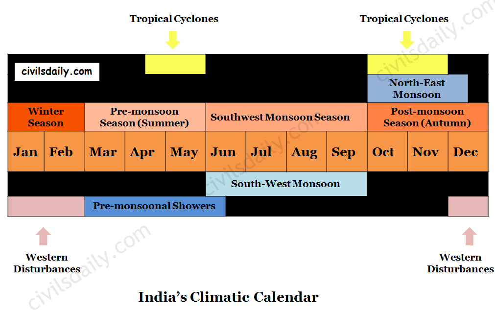
    India’s Climatic Calendar

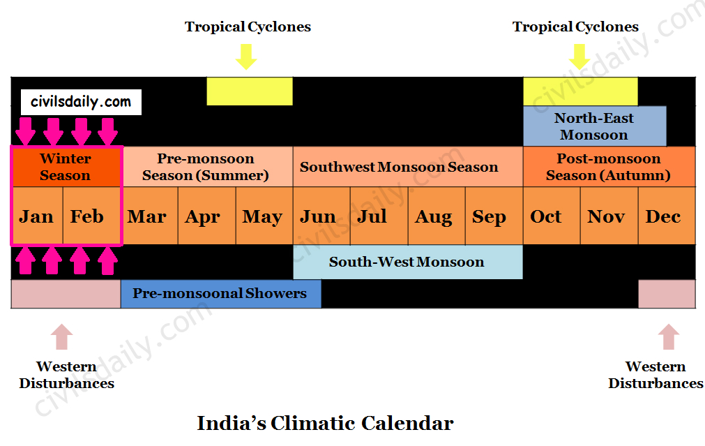
    The climatic conditions of India can best be described in terms of an annual cycle of seasons.

    The India Meteorological Department (IMD) recognises the following four seasons:

      • The Winter Season (January – February)
      • The Pre-monsoon Season or summer season (March – May)
      • The Southwest Monsoon Season or rainy season (June – September)
      • The Post Monsoon Season or autumn season (October – December)

      India’s Climatic Calendar

  • Drainage System | Part 2

    Drainage

    The flow of water through well-defined channels is known as ‘drainage’ and the network of such channels is called a ‘drainage system’.

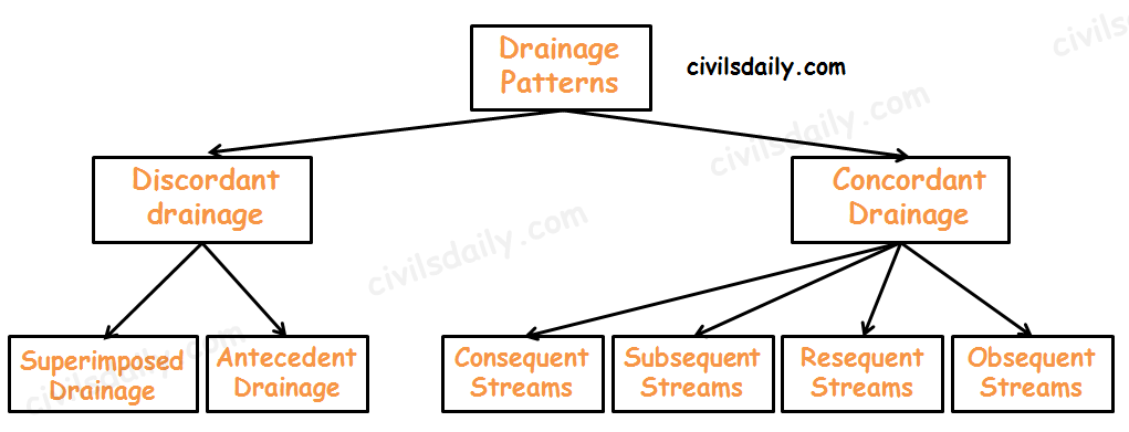
    Types of Drainage Patterns

    Discordant drainage

    A pattern of drainage that bears no relation to the structure of the underlying rock. This may be because:

    • The drainage pattern developed on rock strata that have since been removed by erosion; a process known as superimposition. The drainage pattern thus developed is called superimposed drainage (or Epigenetic or Superinduced Drainage). Examples: The Damodar, the Subarnarekha, the Chambal, the Banas and the rivers flowing at the Rewa Plateau, rivers of eastern USA and southern France.
    • The drainage pattern was already present before a period of uplift and folding that formed the present structure. As the uplift took place, the rivers were able to cut down at approximately the same rate and so maintain their courses. This process is called antecedence and the drainage system thus developed is called antecedent drainage.

    Many of the Himalayan rivers have antecedent origin i.e. these rivers existed even before the Himalayan ranges were uplifted. These rivers originate in the Tibetan side beyond the mountain ranges of Himalayas. The Indus, Satluj, Alaknanda, Gandak, Kosi, Brahmaputra all have an antecedent origin. Since these rivers are antecedent, they run transverse to the mountain ranges cutting deep V-shaped, steep-sided valleys (deep gorges).

    Concordant Drainage (also called accordant drainage)

    The pattern of drainage which arises from and closely follows the trends of the underlying strata is called concordant drainage.

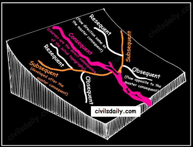
    • Consequent Streams: Those streams whose courses are the direct consequence of the initial topography are called consequent streams.
    • Subsequent Streams: These are developed after the master consequent.
    • Obsequent streams: These flow in opposite direction to the master consequent.
    • Resequent Streams: A resequent stream flows in the same direction as that of the initial consequent stream, but which develops in response to a new base level formed due to inversion of relief.
    Concordant Drainage Patterns

    Drainage pattern:

    Drainage pattern refers to a design which a river and its tributaries form together from its source to its mouth. The drainage pattern of an area is the outcome of:

    • The geological time period,
    • Nature and structure of rocks,
    • Topography,
    • Slope,
    • Amount of water flowing, and
    • The periodicity of the flow.

    Some Important Drainage Patterns:

    A combination of several patterns may be found in the same drainage basin.

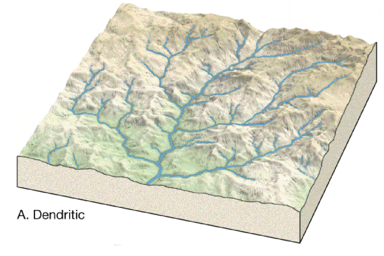
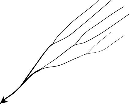
    • Dendritic: The dendritic pattern develops where the river channel follows the slope of the terrain. The drainage pattern resembling the branches of a tree is known as “dendritic” the examples of which are the rivers of northern plain. It is the most common stream pattern. A dendritic pattern develops in a terrain which has uniform lithology, and where faulting and jointing are insignificant.

    Source

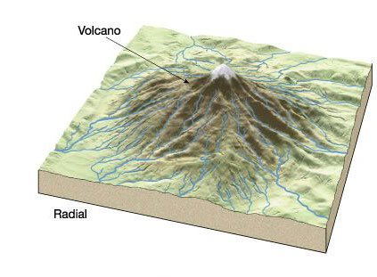
    • Radial: The radial pattern develops when streams flow in different directions from a central peak or a dome-like structure. E.g. the rivers like the Narmada, Son and Mahanadi originating from Maikal Hills flow in different directions and are good examples of a radial pattern.

    Radial drainage patterns are also found/in the Girnar Hills (Kathiwar, Gujarat), and Mikir Hills of Assam.

    Source

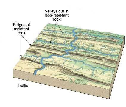
    • Trellis: When the primary tributaries of rivers flow parallel to each other and secondary tributaries join them at right angles, the pattern is known as ‘trellis’. A trellis drainage pattern develops where hard and soft rocks lie parallel to each other. For example, rivers in the upper part of the Himalayan region and in the old folded mountains of the Singhbhum (Chotanagpur Plateau) have drainage of trellis pattern. The trellis drainage pattern can also be seen in the Appalachian region of the U.S.A., where hard and soft rocks occur in parallel bands.

    Source

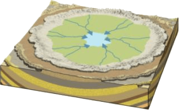
    • Centripetal: When the rivers discharge their waters from all directions in a lake or depression, the pattern is known as ‘centripetal’. This drainage pattern is also called endorheic drainage. For example, Loktak lake in Manipur.

    Source

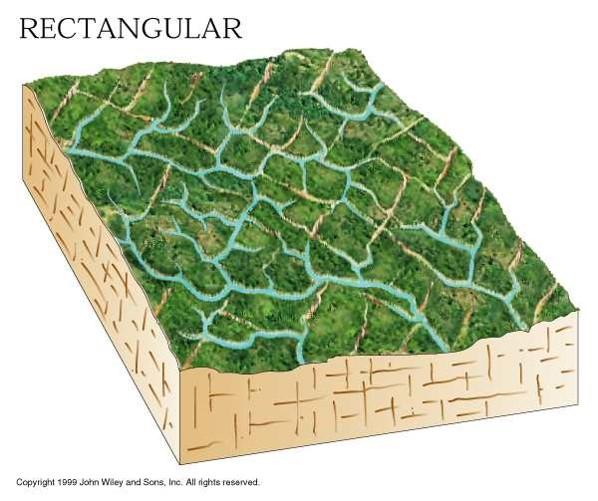
    • Rectangular: In this drainage, both the main stream and its tributaries show right-angled bends. A rectangular drainage pattern develops on a strongly jointed rocky terrain. It differs from trellis pattern drainage, since it is more irregular and its tributary streams are not as long or as parallel as in trellis drainage. Example: Colorado river (USA), streams found is the Vindhyan Mountains of India.

    Source

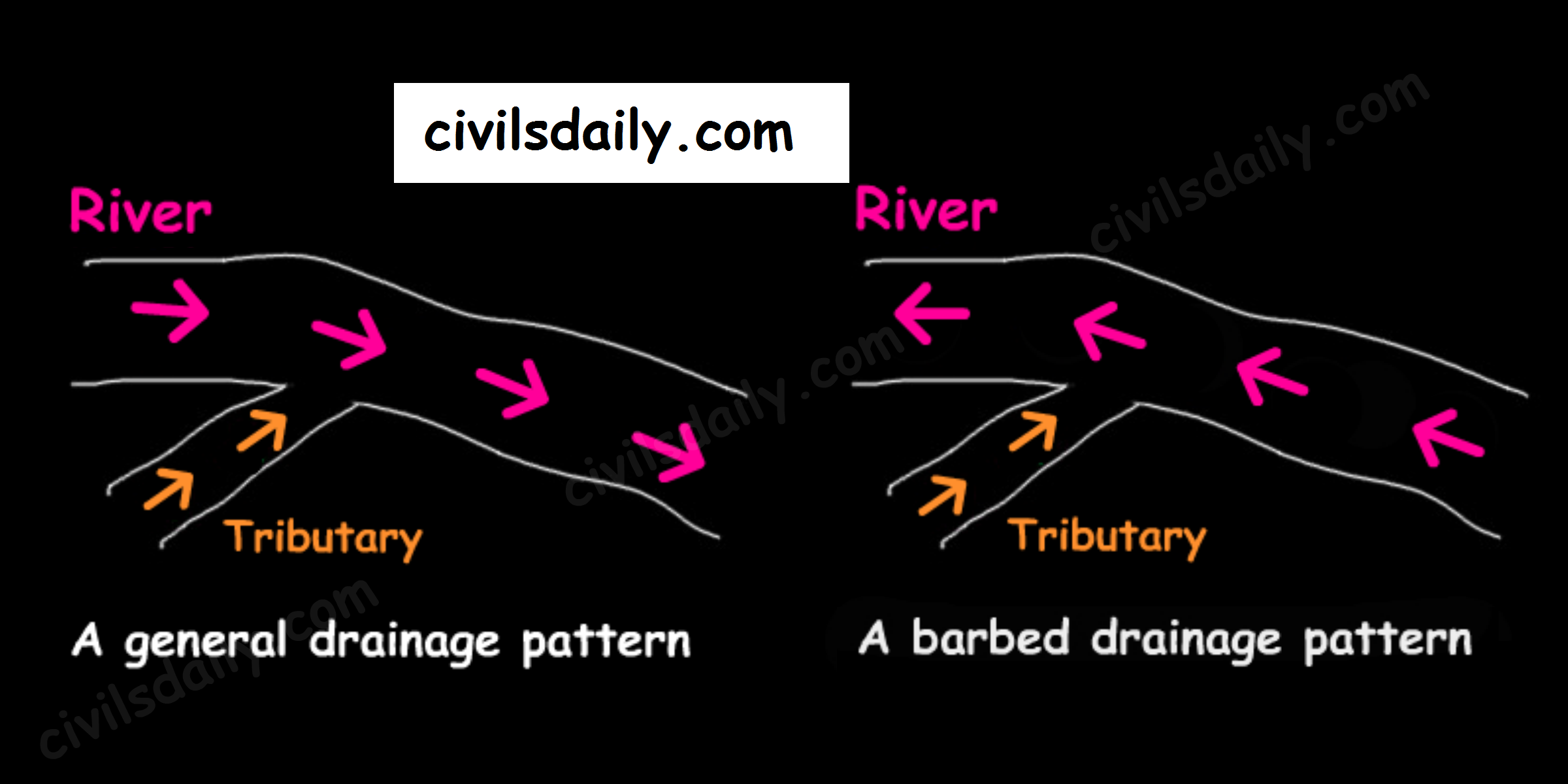
    • Barbed: If you look at the way that tributaries empty into larger rivers, you will notice that most of them flow in the same direction as the rivers they empty into. But quite a large number flow the other way. In fact, you will find stretches of some rivers where every tributary empties into the river in the “wrong” direction! Such an occurrence is known as a barbed drainage pattern.

    Most barbed drainage patterns are the result of river-capture which reverses the direction of flow. However, the tributary channels continue to flow in their original direction.

    The Arun River (Nepal), a tributary of the Kosi is an interesting example of barbed drainage pattern.

    A Barbed Drainage Pattern
    • Annular: Annular pattern represents that part of a drainage pattern in which the subsequent streams follow the curving or arcuate courses before joining the conse­quent stream. These results from a partial adaptation to an underground circular structure i.e. batholiths. This is not a very common drainage pattern in India. Some examples of this are however found in Pithoragarh (Uttarakhand), Nilgiri Hills in Tamil Nadu and Kerala.

    Source

    • Parallel drainage: The drainage pattern in which the rivers flow almost parallel to each other is known as parallel drainage. The small and swift rivers originating in the Western Ghats and discharging their water into the Arabian Sea provide a good example of parallel drainage pattern in India.

    Source

    • Deranged pattern: This is an uncoordinated pattern of drainage characteristic of a region recently vacated by an ice-sheet. The picture is one of numerous water courses, lakes and marshes; some inter-connected and some in local drainage basins of their own. This type of drainage is found in the glaciated valleys of Karakoram.

    Source

  • Drainage System | Part 1

    Before we start with the drainage system of India, let’s look at the broad framework along which we will proceed.

    Article outline:

    • Basic Terminology
      • Source of a river
      • Confluence
      • Tributary
      • Distributary
      • Mouth of a river
      • River basin, catchment area and watershed
      • River Rejuvenation
      • River Regime and River Discharge
    • Drainage – Discordant and Concordant
      • Discordant drainage
        • Antecedent Drainage
        • Superimposed Drainage
      • Concordant Drainage
        • Consequent Streams
        • Subsequent Streams
        • Obsequent Streams
        • Resequent Streams
    • Drainage patterns
      • Dendritic
      • Trellis
      • Rectangular
      • Radial
      • Annular
      • Parallel
      • Centripetal
      • Deranged
      • Barbed
    • The Drainage System of India
      • Classification of Drainage Systems in India
        • On the basis of discharge of water – the Arabian Sea drainage, the Bay of Bengal drainage and inland drainage.
        • On the basis of the size of the watershed – Major, Medium and minor
        • On the basis of the mode of origin, nature and characteristics – the Himalayan drainage and the Peninsular drainage.
      • The Himalayan drainage
        • Evolution
        • Major River systems
      • The Peninsular drainage
        • Evolution
        • Major river systems
      • Differences between the Himalayan and Peninsular river systems
      • The shifting courses of rivers

    Before we study India’s Drainage system, it is imperative that we understand the basic terminology associated with a river and its drainage.

    Source

    Some basic terms:

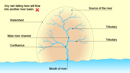
    Source of a river: The beginning or start of a river.

    Confluence: The point at which two rivers or streams join.

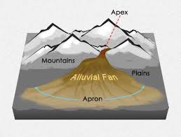
    Distributary: The small river that branches out from the main river and then never meets again. It thus decreases the river’s water volume. Distributaries are commonly found on deltas but are also important in the formation of alluvial fans and cones.

    Tributary: A stream or smaller river which joins a larger stream or river and thus increases its water volume.

    Mouth: The point where the river comes to the end, usually when entering a sea.

    Determination of left/right bank of a river: Stand facing the mouth of the river in the direction of its course. Your left hand side will be the left bank and your right hand side, the right bank.

    River basin, catchment area and watershed

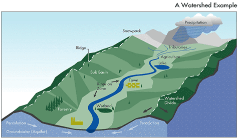
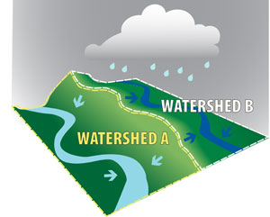
    Generally, the area drained by a river and its tributaries is called its river basin or catchment area or a watershed. But, there are subtle differences between them.

    River Basin: All the area drained by a river and its tributaries.

    Catchment area: It refers to all the area of land over which rain falls and is caught to serve a river basin.

    The catchment area of large rivers or river system is called a river basin while those of small rivers, a lake, a tank is often referred to as a watershed. Watersheds are small in area, generally less than 1000 ha.

    There are many smaller watersheds within a river basin. Example: watershed of Yamuna + water shed of Chambal + watershed of Gandak + …. = Drainage basin of Ganga.

    Watershed:

    Source

    • As a catchment/drainage area: All the land with a common outlet for its surface water ie a geohydrological area from where the water drains to a common point.

    Let’s watch this video for a better understanding:

    • As a water divide: Watershed as a water divide refers to an elevated line from where the water flows in different directions into different river basins.

    Source

    The 3 major watersheds which direct and control the flow of surface water in India are:

    • The Great Himalayan watershed with its important Karakoram branch
    • In Central India, the watershed is formed by Vindhyas, Satpura and Maikala ranges.
    • The Western Ghats.

    A river basin or watershed is often taken as planning unit for macro/micro level developmental planning because:

    • River basins and watersheds are marked by synergy and unity. What happens in one part of the basin or watershed (eg flood, drought etc.) directly affects the other parts and the unit as a whole.
    • The data about land and water characteristics is measurable and comparable.

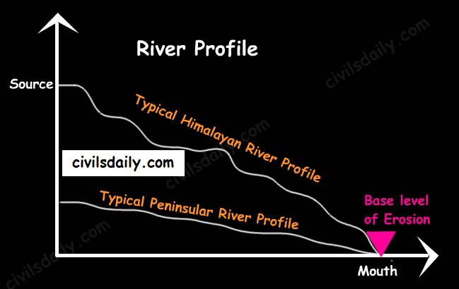
    Base level of erosion and River Profile:

    Base level of erosion: – It is the lowest level to which down-cutting by a river is possible, often referred to as the ‘mouth of the river’. The ultimate base level for any stream is the water body into which it flows – sea, lake, reservoir, dam etc. For large rivers, sea level is usually the base level, but a large river or lake is likewise the base level for tributary streams.

    Under normal circumstances, the goal of a river is to do the work of erosion, initially up to its local and then permanent base level.

    River Profile: It refers to the cross-section of a river from its source to mouth representing the height of the river at various points. The peninsular rivers have almost reached their base levels of erosion.

    River Profile

    River Rejuvenation

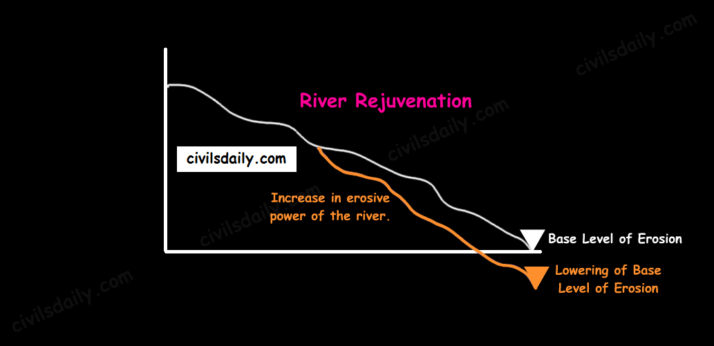
    River Rejuvenation refers to a significant enhancement in the erosive power of the rivers. It can happen because of the following reasons:

    • Fall in the sea level (lowering of base level of erosion)
    • Dynamic upliftment of the land
    • For a given load, if there is a considerable increase in the volume of water.
    • For a given volume of water, if there is a considerable decrease in the load.
    River Rejuvenation

    River Regime and River Discharge:

    Discharge: The volume of water flowing in a river measured over time. It is measured either in cusecs (cubic feet per second) or cumecs (cubic metres per second).

    River regime: It refers to the seasonal fluctuation in respect of volume of water in the river.

    Let’s consider the case of Himalayan and Peninsular rivers. The main differences in their flows are caused by the differences in climate. The main differences are:

    • The regimes of Himalayan Rivers are monsoonal as well as glacial. This is because the Himalayan Rivers are perennial as they are fed by glaciers through snow melt and also receive rainfall water during rainy season. E.g. The river Ganga has its minimum flow during the January-June period, maximum flow is attained either in August or in September followed by a gradual steady fall afterwards.
    • The regimes of most of the peninsular rivers, on the other hand, are monsoonal as they are fed by rainfall alone e.g. the river Narmada has a very low volume of discharge from Jan-July and a sharp rise in August (the rise corresponding with the monsoon season). The fall in October is as spectacular as the rise in August (as the monsoon season ends). It also varies from one part of the Peninsular plateau to the other.
  • The Peninsular Plateau | Part 2

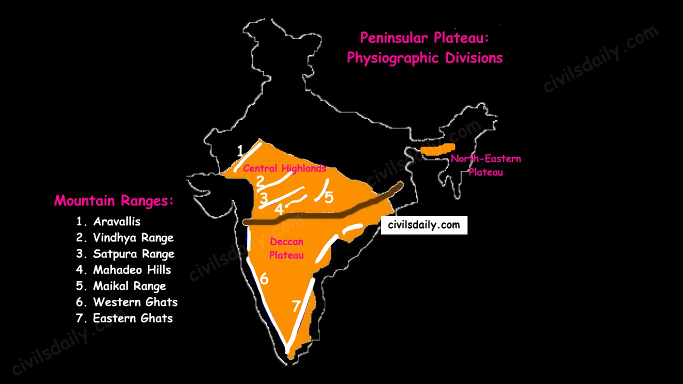
    Physiographic Divisions:

    On the basis of prominent relief features, the peninsular plateau can be divided into three broad groups:

    • The Central Highlands
    • The Deccan Plateau
    • The Northeastern Plateau.
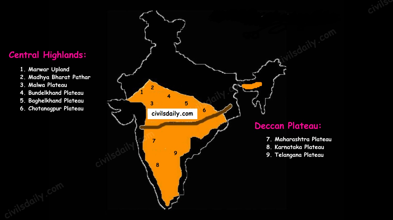
    Physiographic Divisions and Important Mountain Ranges of the Peninsular Plateau

    Let’s take up these divisions one by one:

    1. The Central Highlands

    • The northern segment of the peninsular plateau is known as the Central Highlands.
    • Location:
      1. North of Narmada river.
      2. They are bounded to the west by the Aravallis.
      3. Satpura ranges (formed by a series of scarped plateaus) lie in the South.
    • General Elevation: 700-1,000 m above the mean sea level and it slopes towards the north and northeastern directions.
    • These highlands consist of the:
      • Marwar upland – to the east of Aravallis in Rajasthan
        • A rolling plain carved by Banas river. [Rolling Plain: ‘Rolling plains’ are not completely flat; there are slight rises and fall in the land form. Ex: Prairies of USA]
        • Average elevation is 250-500 m above sea level.
      • Madhya Bharat Pathar – to the east of Marwar upland.
      • Malwa plateau – It lies in Madhya Pradesh between Aravali and Vindhyas. It is composed of extensive lava flow and is covered with black soils.
      • Bundelkhand plateau – It lies along the borders of UP and MP. Because of intensive erosion, semi-arid climate and undulating area, it is unfit for cultivation.
      • Baghelkhand plateau – It lies to the east of the Maikal range.
      • Chhotanagpur plateau – the north–east part of Peninsular plateau.
        • It Includes Jharkhand, parts of Chhattisgarh and West Bengal.
        • This plateau consists of series of step like sub-plateaus (locally called patlands – high-level plateau). It is thus famous as the Patland plateau and known as Ruhr of India.
        • Rajmahal Hills are the northeastern projection of Chhota Nagpur Plateau.
        • It is a mineral rich plateau.
    • The extension of the Peninsular plateau can be seen as far as Jaisalmer in the West, where it has been covered by the longitudinal sand ridges and crescent-shaped sand dunes called barchans.
    • This region has undergone metamorphic processes in its geological history, which can be corroborated by the presence of metamorphic rocks such as marble, slate, gneiss, etc.
    • Most of the tributaries of the river Yamuna have their origin in the Vindhyan and Kaimur ranges. Banas is the only significant tributary of the river Chambal that originates from the Aravalli in the west.
    Physiographic Divisions of the Peninsular Plateau – the Central Highlands and the Deccan Plateau

    2. The Deccan Plateau

    • The Deccan Plateau lies to the south of the Narmada River and is shaped as an inverted triangle.
    • It is bordered by:
      • The Western Ghats in the west,
      • The Eastern Ghats in the east,
      • The Satpura, Maikal range and Mahadeo hills in the north.
    • It is volcanic in origin, made up of horizontal layers of solidified lava forming trap structure with step-like appearance. The sedimentary layers are also found in between the layers of solidified lava, making it inter–trapping in structure.
    • Most of the rivers flow from west to east.
    • The plateau is suitable for the cultivation of cotton; home to rich mineral resources and a source to generate hydroelectric power.
    • The Deccan plateau can be subdivided as follows:
      • The Maharashtra Plateau – it has typical deccan trap topography underlain by basaltic rock, the regur.
      • The Karnataka Plateau (also known as Mysore plateau) – divided into western hilly country region of ‘Malnad’ and plain ‘Maidan’
      • Telangana Plateau

    3. The Northeastern Plateau:

    • The Meghalaya (or Shillong) plateau is separated from peninsular rock base by the Garo-Rajmahal gap.
    • Shillong (1,961 m) is the highest point of the plateau.
    • The region has the Garo, Khasi, Jaintia and Mikir (Rengma) hills.
    • An extension of the Meghalaya plateau is also seen in the Karbi Anglong hills of Assam.
    • The Meghalaya plateau is also rich in mineral resources like coal, iron ore, sillimanite, limestone and uranium.
    • This area receives maximum rainfall from the south-west monsoon. As a result, the Meghalaya plateau has a highly eroded surface. Cherrapunji displays a bare rocky surface devoid of any permanent vegetation cover.

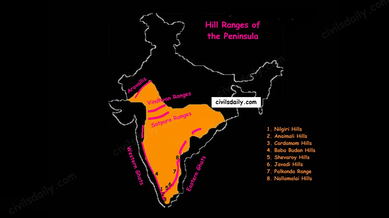
    Hill ranges of the peninsula:

    Most of the hills in the peninsular region are of the relict type (residual hills). They are the remnants of the hills and horsts formed many million years ago (horst: uplifted block; graben: subsided block).

    The plateaus of the Peninsular region are separated from one another by these hill ranges and various river valleys.

    Hill Ranges of the Peninsula

    1. The Aravalli Mountain Range:

    • It is a relic of one of the oldest fold mountains of the world.
    • Its general elevation is only 400-600 m, with few hills well above 1,000 m.
    • At present, it is seen as a discontinuous ridge from Delhi to Ajmer and rising up to 1722m (Gurushikhar peak in Mount Abu) and thence southward.
    • It is known as ‘Jarga’ near Udaipur and ‘Delhi Ridge’ near Delhi.
    • Dilwara Jain Temple, the famous Jain temple is situated on Mt. Abu.

    2. Vindhyan Ranges:

    • They rise as an escarpment running parallel to the Narmada-Son valley.
    • General elevation: 300 to 650 m.
    • Most of them are made up of sedimentary rocks of ancient ages.
    • They act as a watershed between Gangetic and peninsular river systems.

    3. Satpura ranges:

    • Satpura range is a series of seven mountains (‘Sat’ = seven and ‘pura’ = mountains).
    • The seven mountain ranges or folds of Satpura’s are:
      • Maikal Hills
      • Mahadeo Hills near Pachmarhi
      • Kalibhit
      • Asirgarh
      • Bijagarh
      • Barwani
      • Arwani which extends to Rajpipla Hills in Eastern Gujarat.
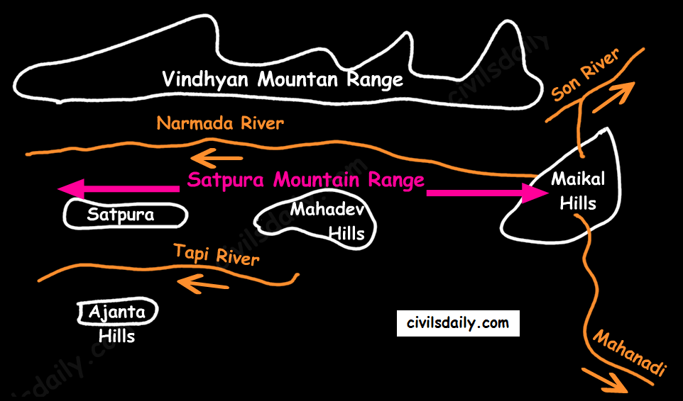
    • Satpura ranges run parallel between Narmada and Tapi, parallel to Maharashtra-MP border.
    • Dhupgarh (1,350 m) near Pachmarhi on Mahadev Hills is the highest peak of the Satpura Range.
    • Amarkantak (1,127 m) is another important peak. Amarkantak is the highest peak of the Maikal Hills from where two prominent rivers – the Narmada and the Son originate.
    • Note that three rivers originate from the three sides of Maikal hills (as shown in the following map) but, from Amarkantak, only two rivers (the Narmada and the Son) originate (and not Mahanadi).
    The Satpura Mountain Range

    4. Western and Eastern Ghats:

    • The Western Ghats:
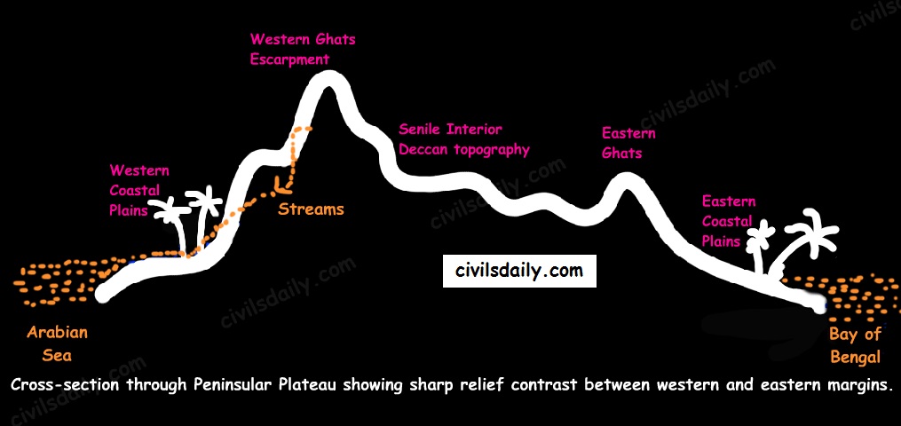
      • These are a faulted part of the Deccan plateau running parallel from the Tapi valley to a little north of Kanyakumari (1600km). Their western slope is like an escarpment while eastern slope merges gently with the plateau.
      • Their average elevation is about 1,500 m with the height increasing from north to south.
    • The Eastern Ghats are in the form of residual mountains which are not regular but broken at intervals.
    • The Eastern and the Western Ghats meet each other at the Nilgiri hills.
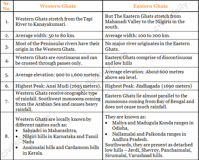
    • A brief comparison between them:
    Differences between the Western and Eastern Ghats.
    A cross-sectional view through the Peninsular Plateau showing sharp relief contrast between the western and eastern margins

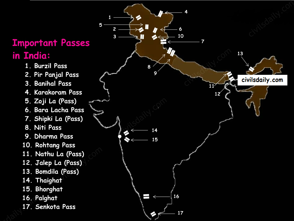
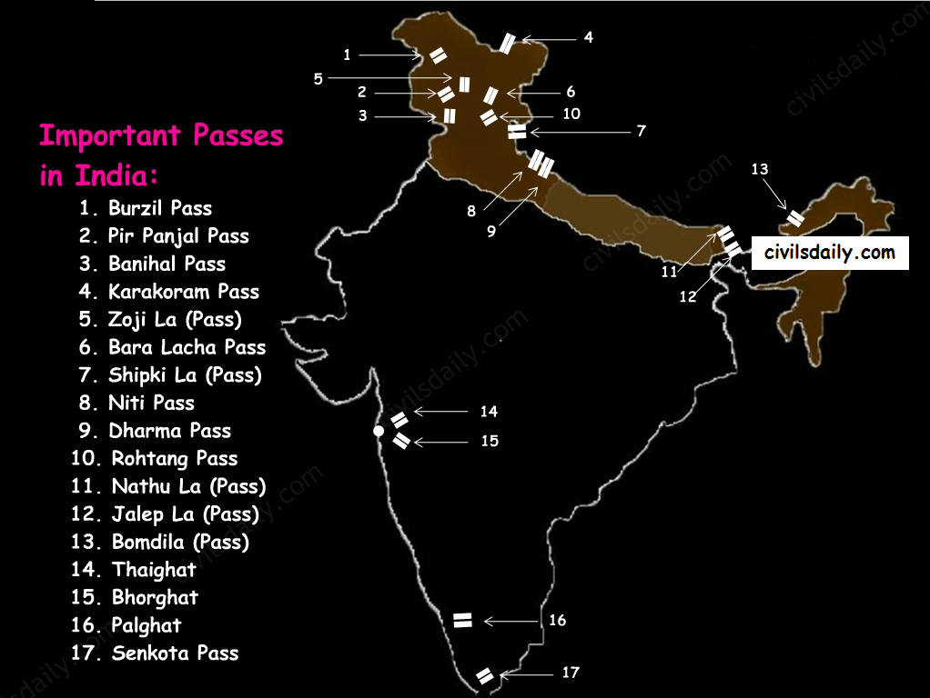
    Note: The Western Ghats are continuous and can be crossed through passes only. There are four main passes which have developed in the Western Ghats. These are:

    • Thal Ghat – It links Nasik to Mumbai.
    • Bhor Ghat – It links Mumbai to Pune.
    • Pal Ghat – This pass is located between the Nilgiris and the Annamalai mountains. It is in Kerala and connects Kochi and Chennai.
    • Senkota Pass – This pass located between the Nagercoil and the Cardamom hills links Thiruvananthapuram and Madurai.

    For the geographical location of these passes, see the following map:

    Important Passes in India

    Significance of the Peninsular Region:

    • Rich in mineral resources: The peninsular region of India is rich in both metallic and non-metallic minerals. About 98% of the Gondwana coal deposits of India are found in the peninsular region.
    • Agriculture: Black soil found in a substantial part of the peninsula is conducive for the cultivation of cotton, maize , citrus fruits etc. Some areas are also suitable for the cultivation of tea, coffee, groundnut etc.
    • Forest Products: Apart from teal, sal wood and other forest products, the forests of Western and Eastern Ghats are rich in medicinal plants and are home to many wild animals.
    • Hydel Power: many rivers, which have waterfalls. They help in the generation of hydroelectric power.
    • Tourism: There are numerous hill stations and hill resorts like Ooty, Mahabaleshwar, Khandala, etc.

    Now that we are done with this part, let’s try to attempt some questions from the past UPSC examinations:

    Prelims:

    1995

    Question: Which one of the following mountain ranges is spread over only one state in India?

    A) Aravalli

    B) Satpura

    C) Ajanta

    D) Sahyadri

    Ans. C

    1997

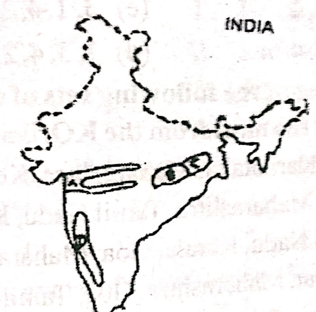
    Question: Consider the map given below:

    camscanner-new-document-10-830920d00b40f30g00b50t10-001

    The places marked A,B, C, and D in the map are respectively

    A) Rift valley region, Chattisgarh plain, Rain shadow region, and Chotanagpur Plateau

    B) Chattisgarh plain , Chotanagpur Plateau, Rift valley region, Rain shadow region

    C) Rift valley region, Chattisgarh plain, Chotanagpur Plateau and Rain shadow region

    D) Chattisgarh plain , Rain shadow region, Chotanagpur Plateau, Rift valley region,

    Ans. C

    2005

    Question: Which one of the following statements is not correct?

    A) The Western Ghats are relatively higher in their northern regions.

    B) The Anaimudi is the highest peak in the Western Ghats

    C) Tapi river lies to the south of Satpura

    D) The Narmada and the Tapi river valleys are said to be old rift valleys.

    Ans. A

    Question: Which one of the following is the correct sequence of the given hills starting from the north and going towards the south?

    A) Nallamalai Hills – Nilgiri Hills – Javadi Hills – Anaimalai Hills

    B) Anaimalai Hills – Javadi Hills – Nilgiri Hills – Nallamalai Hills

    C) Nallamalai Hills – Javadi Hills – Nilgiri Hills – Anaimalai Hills

    D) Anaimalai Hills – Nilgiri Hills – Javadi Hills – Nallamalai Hills

    Ans. C

    2007

    Question: In which state is the Guru Shikhar peak located?

    1. Rajasthan
    2. Gujarat
    3. Madhya Pradesh
    4. Maharashtra

    Ans. A

  • The Peninsular Plateau | Part 1

    Article Outline:

    • Location and Extent
    • Geological History and Features
    • Chief Characteristics
      • General elevation and flow of rivers
      • Important physiographic features
      • The Deccan Trap
    • Physiographic Divisions
      • The Central Highlands
      • The Deccan Plateau
      • The Northeastern Plateau.
    • Hill ranges of the peninsula
      • The Aravallis
      • Vindhyan Ranges
      • Satpura ranges
      • Western and Eastern Ghats
    • Significance of this region

    Peninsular Plateau is the oldest and largest Physiographic unit of India.

    A. Location and Extent

    • The Peninsular Plateau lies to the south of the Northern Plains of the India.
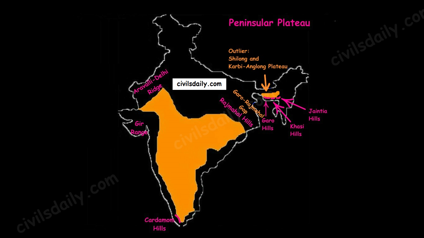
    • It is bordered on all sides by the hill ranges:
    • Delhi ridge in the north-west (extension of Aravalis),
    • the Rajmahal hills in the east,
    • Gir range in the west, and
    • the Cardamom hills in the south constitute the outer extent of the peninsular plateau.
    The Physiographic Divisions of India | The Peninsular Plateau
    • Outlier:
      • Shillong and Karbi-Anglong plateau.

    Note: Kutchch Kathiawar region – The region, though an extension of Peninsular plateau (because Kathiawar is made of the Deccan Lava and there are tertiary rocks in the Kutch area), they are now treated as integral part of the Western Coastal Plains as they are now levelled down.

    • The Garo-Rajmahal Gap:
      • The two disconnected outlying segments of the plateau region are seen in the Rajmahal and Garo-Khasi Jaintia hills.
      • It is believed that due to the force exerted by the northeastward movement of the Indian plate at the time of the Himalayan origin, a huge fault was created between the Rajmahal hills and the Meghalaya plateau
      • Later, this depression got filled up by the deposition activity of the numerous rivers.
      • As a result, today the Meghalaya and Karbi Anglong plateau stand detached from the main Peninsular Block.

    Geological History and Features:

    The peninsular plateau is a tableland which contains igneous and metamorphic rocks. It is one of the oldest and the most stable landmass of India.

    In its otherwise stable history, the peninsula has seen a few changes like:

    • Gondwana Coal Formation.
    • Narmada-Tapi rift valley formation.
    • Basalt Lava eruption on Deccan plateau:

    During its journey northward after breaking off from the rest of Gondwana, the Indian Plate passed over a geologic hotspot, the Réunion hotspot, which caused extensive melting underneath the Indian Craton. The melting broke through the surface of the craton in a massive flood basalt event, creating what is known as the Deccan Traps (Its various features have been discussed in the later portion of the article).

    Chief Characteristics:

    The entire peninsular plateau region is an aggregation of several smaller plateaus and hill ranges interspersed with river basins and valleys. The Chhattisgarh plain occupied by the dense Dandakaranya forests is the only plain in the peninsula.

    1. General elevation and flow of rivers:

    • The average elevation is 600-900 metres.
    • The general elevation of the plateau is from the west to the east, which is also proved by the pattern of the flow of rivers.
    • Barring Narmada and Tapti all the major rivers lying to the south of the Vindhyas flow eastwards to fall into the Bay of Bengal.
    • The westward flow of Narmada and Tapi is assigned to the fact that they have been flowing through faults or rifts which were probably caused when the Himalayas began to emerge from the Tethys Sea of the olden times.

    2. Some of the important physiographic features of this region are:

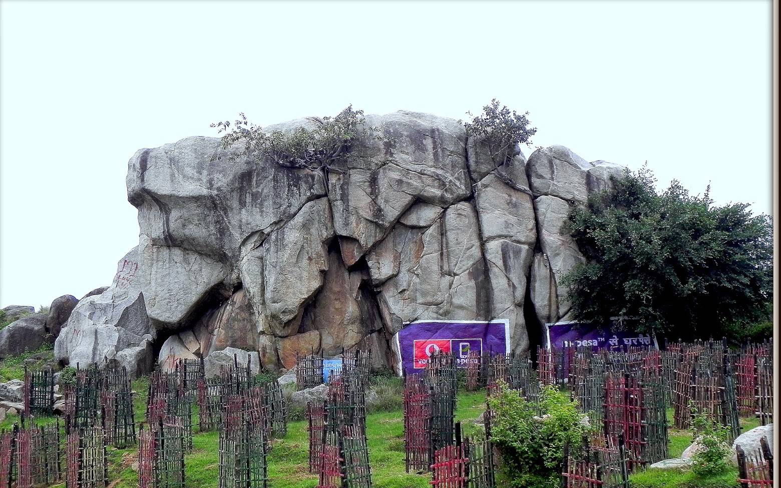
    • Tors – Prominent, isolated mass of jointed, weathered rock, usually granite.

    A granite tor near Ranchi

    A granite tor near Ranchi

    • Block Mountains and Rift Valleys:
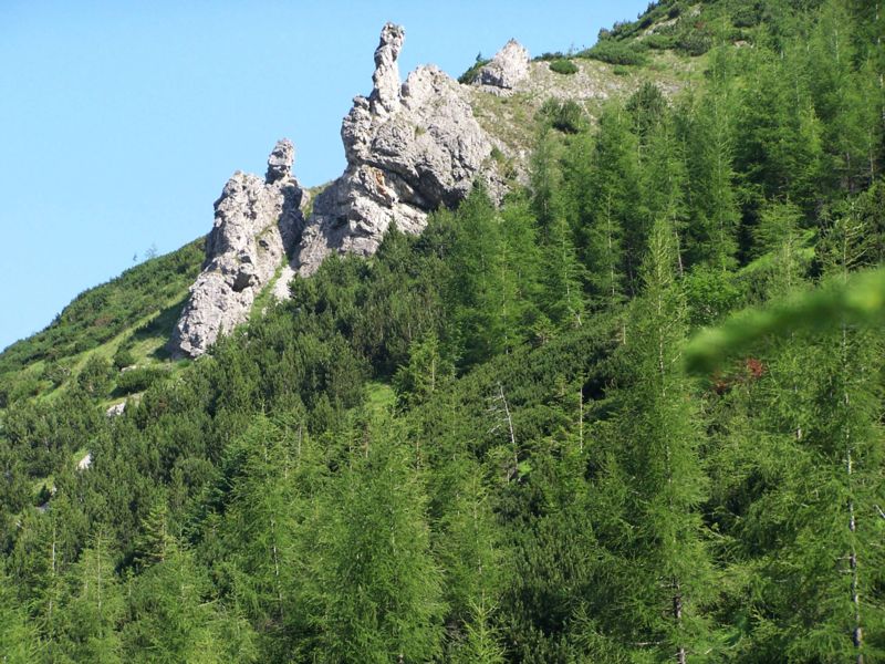
    • Spurs: A marked projection of land from a mountain or a ridge

    spur

    Image Source

    • Bare rocky structures,
    • Series of hummocky hills and wall-like quartzite dykes offering natural sites for water storage.
    • Broad and shallow valleys and rounded hills
    • Ravines and gorges: The northwestern part of the plateau has a complex relief of ravines and gorges. The ravines of Chambal, Bhind and Morena are some of the well-known examples.

    3. The Deccan Traps:

    • One of the most important features of the peninsular plateau is the black soil area in the western and northwestern part of the plateau, which is known as the Deccan Trap.
    • From the end of the Cretacious until the beginning of the Eocene, numerous fissure-type eruptions took place in the north-western part of the Deccan plateau. It is believed that the lava outpourings were more than the mass comprising the present-day Himalayas.
    • It covers a major portion of the Maharashtra plateau and parts of Gujarat, northern Karnataka and Malwa plateau. Some parts of Tamil Nadu, Andhra Pradesh, UP, and Jharkhand have some outliers of Deccan trap.
    • Basalt is the main rock of the region.
    • The region has black cotton soil as a result of weathering of this lava material and this soil is one of the finest examples of the parent material controlled soils.
  • The Northern Plains | Part 2

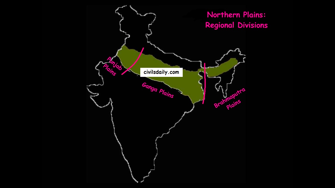
    The Regional Divisions of the Northern Plains: Punjab, Ganga and the Brahmaputra Plains.
    1. Punjab Plains:
    • The Punjab plains form the western part of the northern plain.
    • In the east, the Delhi-Aravalli ridge separates it from the Ganga plains.
    • This is formed by the Indus and its tributaries; like Jhelum, Chenab, Ravi, Beas and Sutlej. A major portion of these plains is in Pakistan.
    • It is divided into many Doabs (do-“two” + ab- “water or river” = “a region or land lying between and reaching to the meeting of the two rivers”).
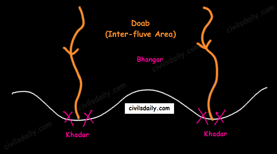
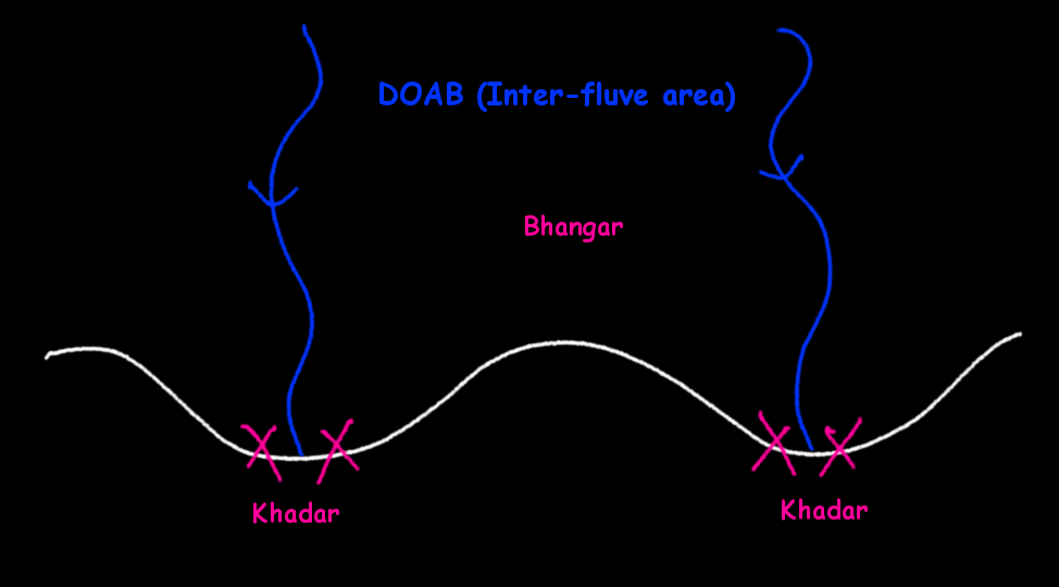
      Khadar and Bhangar


    • Important features:
      • Khadar rich flood plains known as ‘Betlands’ or ‘Bets’.
      • The rivers in Punjab-Haryana plains have broad flood plains of Khadar flanked by bluffs, locally known as Dhayas.
      • The northern part of this plane adjoining the Shivalik hills has been heavily eroded by numerous streams, which are called Chhos.
      • The southwestern parts, especially the Hisar district is sandy and characterized by shifting sand-dunes.
    1. Ganga Plains:
    • The Ganga plains lie between the Yamuna catchment in the west to the Bangladesh border in the East.
    • The lower Ganga plain has been formed by the downwarping of a part of the Peninsular India between Rajmahal hills and the Meghalaya plateau and subsequent sedimentation by the Ganga and Brahmaputra rivers.
    • The main topographical variations in these plains include Bhabar, Tarai, Bhangar, Khadar, levees, abandoned courses etc.
    • Almost all the rivers keep on shifting their courses making this area prone to frequent floods. The Kosi river is very notorious in this respect. It has long been called the ‘Sorrow of Bihar’.
    • The northern states, Haryana, Delhi, UP, Bihar, part of Jharkhand and West Bengal in the east lie in the Ganga plains.
    • The Ganga-Brahmaputra delta: the largest delta in the world. A Large part of the coastal delta is covered tidal forests called Sunderbans. Sunderbans, the largest mangrove swamp in the world gets its name from the Sundari tree which grows well in marshland. It is home to the Royal Tiger and crocodiles.
    1. Brahmaputra Plains:
    • This plain forms the eastern part of the northern plain and lies in Assam.
    • Its western boundary is formed by the Indo-Bangladesh border as well as the boundary of the lower Ganga Plain. Its eastern boundary is formed by Purvanchal hills.
    • The region is surrounded by high mountains on all sides, except on the west.
    • The whole length of the plain is traversed by the Brahmaputra.
    • The Brahmaputra plains are known for their riverine islands (due to the low gradient of the region) and sand bars.
    • The innumerable tributaries of the Brahmaputra river coming from the north form a number of alluvial fans. Consequently, the tributaries branch out in many channels giving birth to river meandering leading to the formation of bill and ox-bow lakes.
    • There are large marshy tracts in this area. The alluvial fans formed by the coarse alluvial debris have led to the formation of terai or semi-terai conditions.

    Significance of this region:

    • The plains constitute less than one-third of the total area of the country but support over 40 percent of the total population of the country.
    • Fertile alluvial soils, flat surface, slow moving perennial rivers and favourable climate facilitate an intense agricultural activity.
    • The extensive use of irrigation has made Punjab, Haryana and western part of Uttar Pradesh the granary of India (Prairies are called the granaries of the world).
    • Cultural tourism: Several sacred places and centres of pilgrimage are situated in these plains e.g. Haridwar, Amritsar, Varanasi, Allahabad, Bodh Gaya etc.
    • The sedimentary rocks of plains have petroleum and natural gas deposits.
    • The rivers here have very gentle gradients which make them navigable over long distances.

    Now that we are done with this part, let’s try to attempt some questions from the past UPSC examinations:

    Prelims:

    2000

    Question: Assertion (A): The frequency of floods in North Indian plains has increased during the last couple of decades.

    Reason(R): There has been reduction in the depth of river valleys due to deposition of silt.

    Ans. A (Both A and B are true and R is the correct explanation of A)

    Question: Assertion (A): Ganga plain is the most densely populated part of India.

    Reason(R): Ganga is the most harnessed river of India.

    Ans. C (A is true but R is false)

    Mains:

    Question: Write a short note on Tarai region. (2008/2marks)

  • The Northern Plains | Part 1

    Article Outline:

    • Location and Extent
    • Formation of Northern Plains
    • Chief Characteristics
    • Physiographic Division
      • The Bhabar
      • The Terai
      • The Bhangar
      • The Khadar
    • Regional Divisions
    • Significance of this region

    Location and Extent:

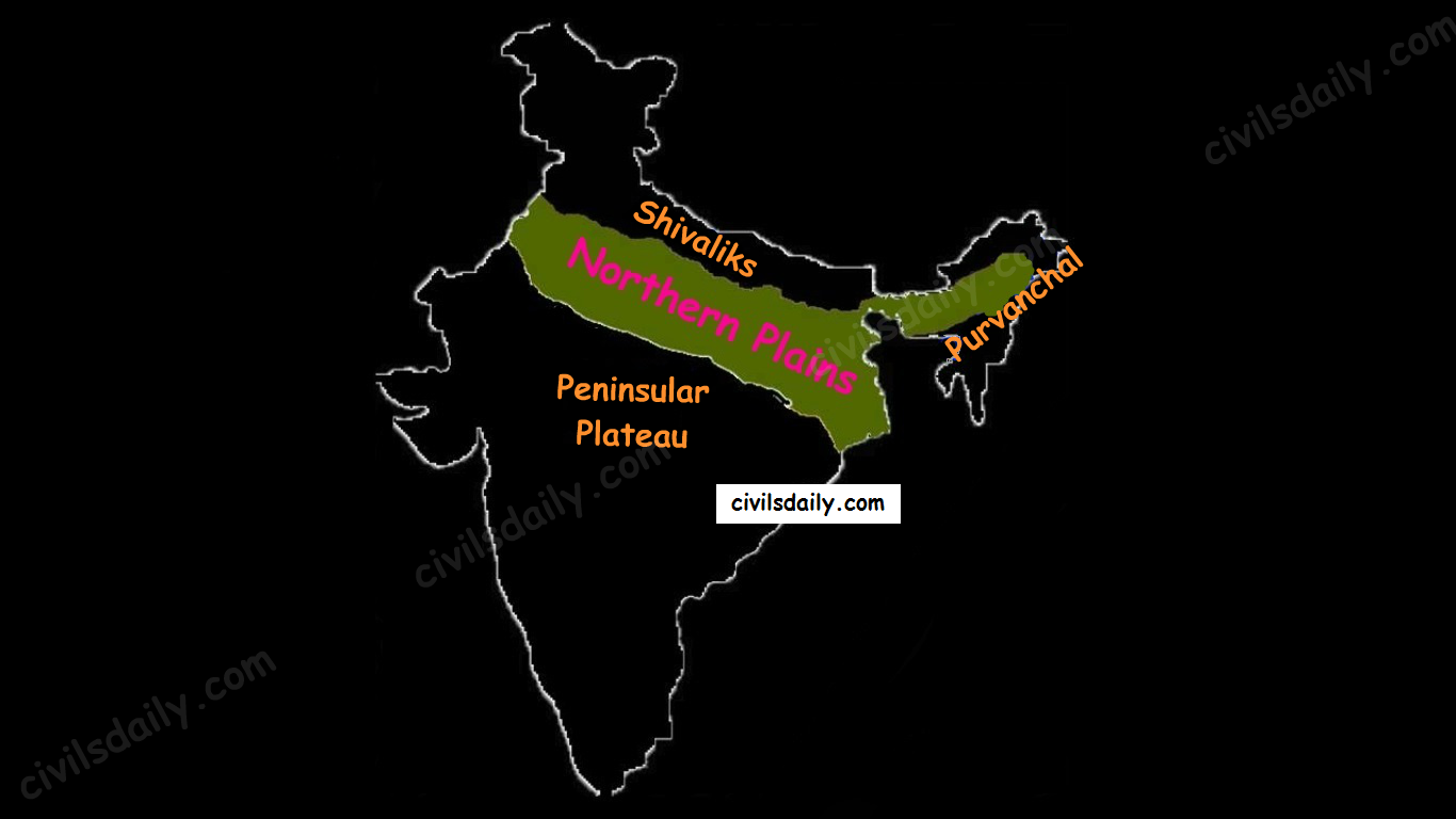
    Northern plains are the youngest physiographic feature in India. They lie to the south of the Shivaliks, separated by the Himalayan Frontal Fault (HFF). The southern boundary is a wavy irregular line along the northern edge of the Peninsular India. On the eastern side, the plains are bordered by the Purvanchal hills.

    The Physiographic Divisions of India: the Northern Plains

    Formation of Northern Plains:

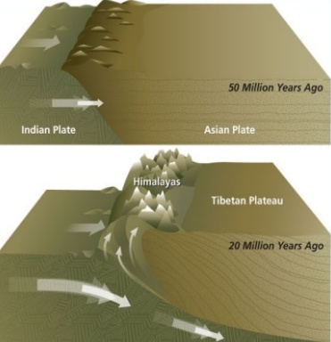
    Due to the uplift of the Himalayas in the Tethys Sea, the northern part of the Indian Peninsula got subsided and formed a large basin.

    northern-plains

    Source

    That basin was filled with sediments from the rivers which came from the mountains in the north and from the peninsula in the south. These extensive alluvial deposits led to the formation of the northern plains of India.

    Chief Characteristics:

    • The northern plain of India is formed by three river systems, i.e. the Indus, the Ganga and the Brahmaputra; along with their tributaries.
    • The northern plains are the largest alluvial tract of the world. These plains extend approximately 3200 km from west to east.
    • The average width of these plains varies between 150 and 300 km. In general, the width of the northern plains increases from east to west (90-100km in Assam to about 500km in Punjab).
    • The exact depth of alluvium has not yet been fully determined. According to recent estimates, the average depth of alluvium in the southern side of the plain varies between 1300-1400m, while towards the Shiwaliks, the depth of alluvium increases. The maximum depth of over 8000m has been reached in parts of Haryana.
    • The extreme horizontality of this monotonous plain is its chief characteristic (200m – 291m). The highest elevation of 291 m above mean sea level near Ambala forms a watershed between Indus system and Ganga system).
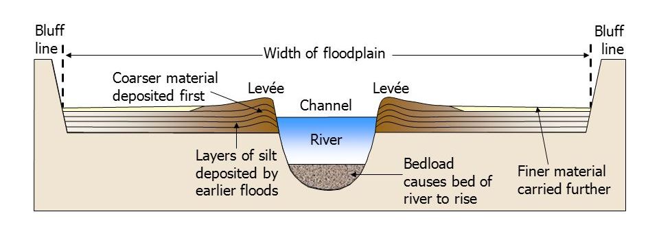
    • The monotony of the physical landscape is broken at the micro level by the river bluffs, levees etc.
      • [Floodplain – That part of a river valley, adjacent to the channel, over which a river flows in times of a flood.
      • Levee – An elevated bank flanking the channel of the river and standing above the level of the flood plain.
      • Bluff – A river cut cliff or steep slope on the outside of a meander. A line of bluffs often marks the edge of a former floodplain.]

    slide_34

    Source

    Physiographic Divisions of the Northern Plains:

    From the north to the south, the northern plains can be divided into three major zones:

    • The Bhabar
    • The Tarai
    • The alluvial plains.

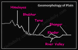
    The alluvial plains can be further divided into the Khadar and the Bhangar as illustrated below:

    Geomorphology of the Northern Plains

    Let’s understand these divisions one by one:

    Bhabar:

    • Bhabar is a narrow belt (8-10km wide) which runs in the west-east direction along the foot of the Himalayas from the river Indus to Teesta.
      alluvial-fan

      Source

    • Rivers which descend from the Himalayas deposit their load along the foothills in the form of alluvial fans.
    • These fans consisting of coarser sediments have merged together to build up the piedmont plain/the Bhabar.
    • The porosity of the pebble-studded rock beds is very high and as a result, most of the streams sink and flow underground. Therefore, the area is characterized by dry river courses except in the rainy season.
    • The Bhabar tract is not suitable for cultivation of crops. Only big trees with large roots thrive in this region.
    • The Bhabar belt is comparatively narrow in the east and extensive in the western and north-western hilly region.

    Tarai:

    • It is a 10-20 km wide marshy region in the south of Bhabar and runs parallel to it.
    • The Tarai is wider in the eastern parts of the Great Plains, especially in the Brahmaputra valley due to heavy rainfall.
    • It is characterized by the re-emergence of the underground streams of the Bhabar belt.
    • The reemerged water transforms large areas along the rivers into badly drained marshy lands.
    • Once covered with dense forests, most of the Tarai land (especially in Punjab, Uttar Pradesh and Uttarakhand) has been reclaimed and turned into agricultural land over a period of time.

    Bhangar:

    • It is the older alluvium along the river beds forming terraces higher than the flood plain.
    • Dark in colour, rich in humus content and productive.
    • The soil is clayey in composition and has lime modules (called kankar)
    • Found in doabs (inter-fluve areas)
    • ‘The Barind plains’ in the deltaic region of Bengal and the ‘bhur formations’ in the middle Ganga and Yamuna doab are regional variations of Bhangar. [Bhur denotes an elevated piece of land situated along the banks of the Ganga river especially in the upper Ganga-Yamuna Doab. This has been formed due to accumulation of wind-blown sands during the hot dry months of the year]
    • In relatively drier areas, the Bhangar also exhibits small tracts of saline and alkaline efflorescence known as ‘Reh’, ‘Kallar’ or ‘Bhur’. Reh areas have spread in recent times with increase in irrigation (capillary action brings salts to the surface).
    • May have fossil remains of even those plants and animals which have become extinct.

    Khadar:

    • Composed of newer alluvium and forms the flood plains along the river banks.
    • Light in colour, sandy in texture and more porous.
    • Found near the riverbeds.
    • A new layer of alluvium is deposited by river flood almost every year. This makes them the most fertile soils of Ganges.
    • In Punjab, the Khadar rich flood plains are locally known as ‘Betlands’ or ‘Bets’.
    • The rivers in Punjab-Haryana plains have broad flood plains of Khadar flanked by bluffs, locally known as Dhayas. These bluffs are as high as 3metres.
  • Geography of India: An Introduction


    As the 7th largest country in the world, India stands apart from the rest of Asia, marked off as it is by mountains and the sea, which give the country a distinct geographical entity.

    Bounded by the Great Himalayas in the north, it stretches southwards and at the Tropic of Cancer, tapers off into the Indian Ocean between the Bay of Bengal on the east and the Arabian Sea on the west.

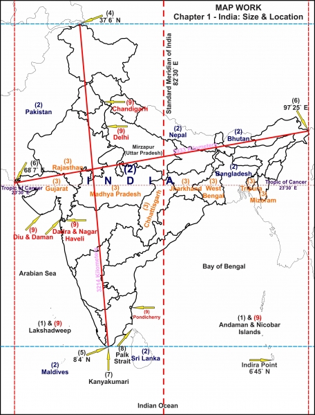
    geographical-extent-of-india

    Map-key 

    • The island groups of India lying in the Arabian Sea and the Bay of Bengal.
    • The countries constituting Indian Subcontinent.
    • The states through which the Tropic of Cancer passes.
    • The northernmost latitude in degrees (Indira Col in Jammu and Kashmir).
    • The southernmost latitude of the Indian mainland in degrees (Kanyakumari in Tamil Nadu). Note that the southernmost point of India is the Indira Point which is the southernmost point of Great Nicobar Island of the Andaman and Nicobar archipelago. The Indira Point was previously known as the Pygmalion Point or the Parson Point.
    • The eastern and the westernmost longitudes in degrees.
    • The place situated on the three seas.
    • The strait separating Sri Lanka and India.
    • The Union Territories of India.

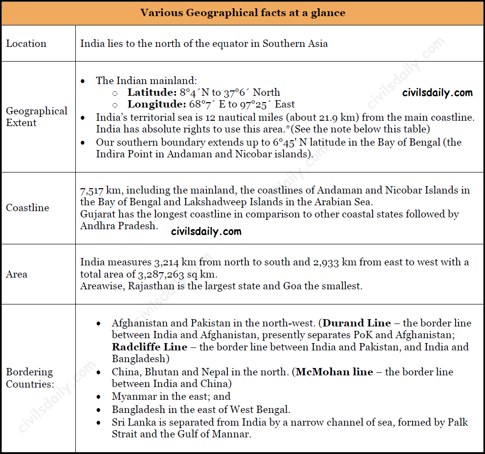
    Let’s take a look at latitudinal and longitudinal extend of India:

    India: Various Geographical Facts at a Glance

    *Note

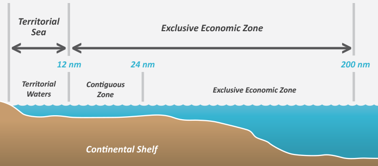
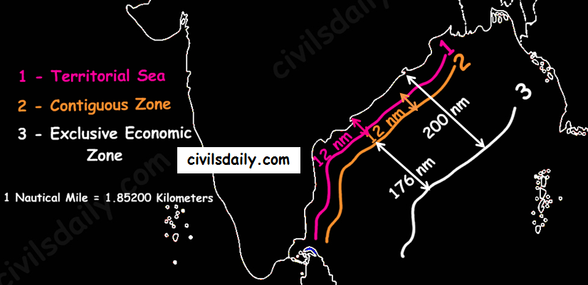
    Contiguous Zone – The area ahead of the territorial sea frontier and 24 nautical miles from the main coastline is known as the contiguous zone. In this area, India has the fiscal rights, excise duty rights, rights related to pollution control and right to implement immigration laws.

    The nautical region ahead of the contiguous zone which is up to 200 nautical miles from the main coastline is known as the Exclusive Economic Zone (EEZ). In this region India has rights to survey, exploitation, conservation and research on mineral resources, marine life etc.]

    Source
    Territorial Sea, Contiguous Zone and Exclusive Economic Zone of India

    Observe India’s latitudinal and longitudinal extent. Do you notice that while both the latitudinal and longitudinal extent are roughly about 30 degrees, the actual distance measured from north to south extremity is 3,214 km and that from east to west is only 2,933 km!

    What is the reason for this difference in India Coordinates?

    This is because:

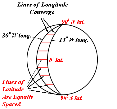
    Degrees of latitude are parallel so the distance between each degree remains almost constant but since degrees of longitude are farthest apart at the equator and converge at the poles, their distance varies greatly. See the following figure to understand better:

    longitude-and-latitude

    Source

    The longitudinal extent and its implications

    The longitudinal extent of India is 30 degrees. As the sun rises in the east and sets in the west; it takes 4 minutes for the sun to move across 1 longitude.

    Thus, the easternmost point of India would be 2 hours ahead of the westernmost point (30 x 4 = 120 minutes), in accordance with the local time.

    This difference in time might create confusion in air and rail timings and so many other things across the two states. To avoid this confusion, 82°30′ East longitude is taken as the Standard Time Meridian of India and its local time is taken a standard throughout the country.

    The latitudinal extent and its implications

    • The difference between the length of day and night in southern most part of India is much less only about 45 minutes as they are situated near the equator. This difference between day and night in the northern parts of India steadily goes on increasing till it becomes as much as 5 hours.
    • The Tropic of Cancer passes almost halfway through the country. Thus half of the country to the south of the Tropic of Cancer is situated in the Tropical or Torrid zone and the other half lying north of the Tropic of Cancer falls in the Subtropical zone. This location is responsible for large variations in landforms, climate, soil types and natural vegetation in the country. Wondering how?

    Let’s try and understand

    Latitudinal Extent of India and its Implications

    Also,

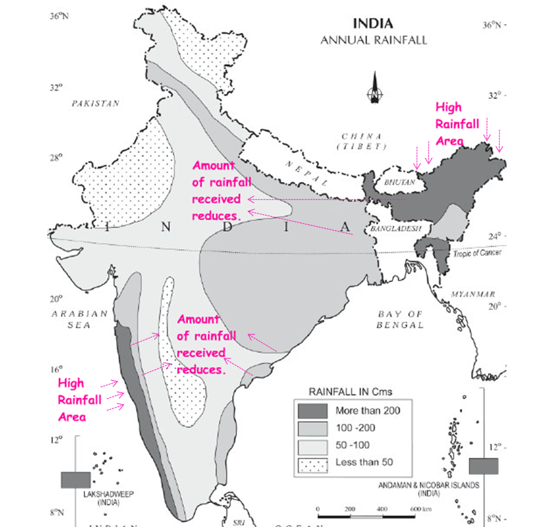
    • Areas closer to the coast would experience greater rainfall
    • And, as we move towards the interior areas, the moisture content of clouds and hence the rainfall experienced would decrease.

    These rules broadly define the distribution of rainfall in the country as can be seen in the map below:

    untitled

    Source

    Still wondering how this influences the soil types and vegetation?

    Rainfall experienced by a region, in turn, plays an important role in determining the soil type in that region. For example:

    • Areas of high rainfall (>200cm) –> Nutrients seep to lower layers –> laterization of soil. Laterite soils are thus found in these areas.

    Further, in these areas: Hot and humid climate + Abundant rainfall = favourable conditions for vegetation growth. As a result, the vegetation here is very dense and multilayered with evergreens [Also, called Tropical Evergreen Forests as we will discuss later]

    • Similarly, in areas with 100-200cm of rainfall –> Red and Yellow soils

    The upper layer of Red soils appears red due to the presence of iron. When the rainfall is in the range of 100-200cm, the rainwater tends to seep to the second layer of soil. Red soils appear yellow in hydrated form, thus the second layer of soils in these areas is yellow in colour.

    • In areas of low rainfall – less than 60cm, we find Desert Soil (or arid soil): This soil is derived from the disintegration of adjacent rocks and is largely blown from coastal regions and Indus Valley. The low rainfall dictates the type of vegetation, prominent features of which are small leaves, thick bark and long roots. [Also, called Tropical Thorny Vegetation as we will discuss later]

    That’s it for this introductory post on Indian Geography.

  • The Northern and Northeastern Mountains | Part 2

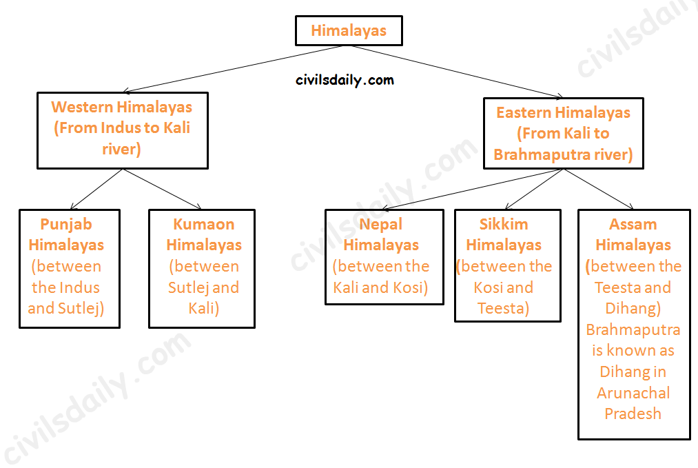
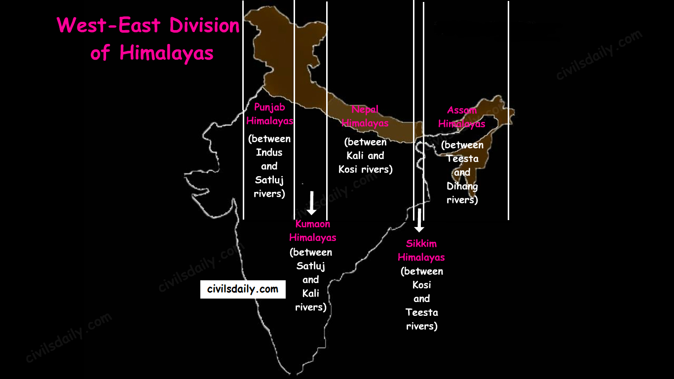
    Besides the longitudinal divisions, the Himalayas have been divided on the basis of regions from west to east:

    These divisions have been demarcated by river valleys:

    The Regional Divisions of Himalayas – the Western and Eastern Himalayas.
    1. Punjab Himalayas:
      • A large portion of Punjab Himalayas is in Jammu and Kashmir and Himachal Pradesh. Hence they are also called the Kashmir and Himachal Himalaya.
      • Major ranges: Karakoram, Ladakh, Pir Panjal, Zaskar and Dhaola Dhar.
      • The general elevation falls westwards.
      • The Kashmir Himalayas are also famous for Karewa formations.
        • ‘Karewas’ in Kashmiri language refer to the lake deposits, found in the flat-topped terraces of the Kashmir valley and on the flanks of the Pir Panjal range.
        • These deposits consist of clays, silts and sands, these deposits also show evidence of glaciation.
        • The occurrence of tilted beds of Karewas at the altitudes of 1500-1800m on the flanks of the Pir Panjal strongly suggests that the Himalayas were in process of uplift as late as Pliocene and Pleistocene (1.8mya to 10kyears ago)
        • Karewas are famous for the cultivation of Zafran, a local variety of saffron.
    2. Kumaon Himalayas
    3. Nepal Himalayas:
      • Tallest section of Himalayas
    4. Sikkim Himalayas:
      • Teesta river originates near Kanchenjunga
      • Jelep la pass- tri-junction of India- China-Bhutan
    5. Assam Himalayas:
      • Himalayas are narrower in this region and Lesser Himalayas lie close to Great Himalayas.
      • Peaks: Namcha Barwa, Kula Kangri
      • Bengal ‘Duars’
      • Diphu pass- tri-junction of India- China-Myanmar
      • The Assam Himalayas show a marked dominance of fluvial erosion due to heavy rainfall.
    The West-East Division of Himalayas

    Glaciers and Snowline:

    • Snowline: The lower limit of perpetual snow is called the ‘snowline’. The snowline in the Himalayas has different heights in different parts, depending on latitude, altitude, amount of precipitation, moisture, slope and local topography.

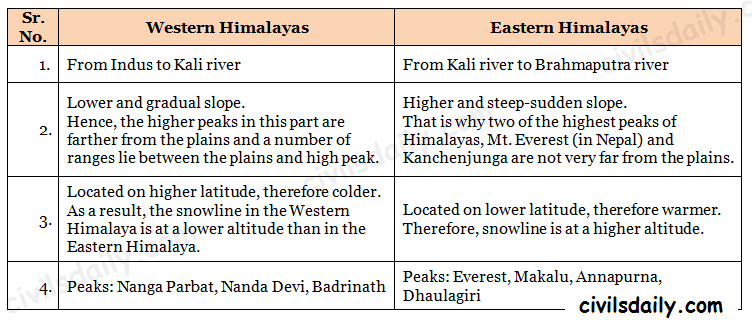
    1. The snowline in the Western Himalaya is at a lower altitude than in the Eastern Himalaya. E.g. while the glaciers of the Kanchenjunga in the Sikkim portion hardly move below 4000m, and those of Kumaon and Lahul to 3600m, the glaciers of the Kashmir Himalayas may descend to 2500m above the sea level.

    • It is because of the increase in latitude from 28°N in Kanchenjunga to 36°N in the Karakoram (Lower latitude —> warmer temperatures —> higher snowline).
    • Also, the Eastern Himalayas rise abruptly from the planes without the intervention of High ranges.
    • Though the total precipitation is much less in the western Himalayas, it all takes place in the form of snow.

    2. In the Great Himalayan ranges, the snowline is at a lower elevation on the southern slopes than on the northern slopes. This is because the southern slopes are steeper and receive more precipitation as compared to the northern slopes.

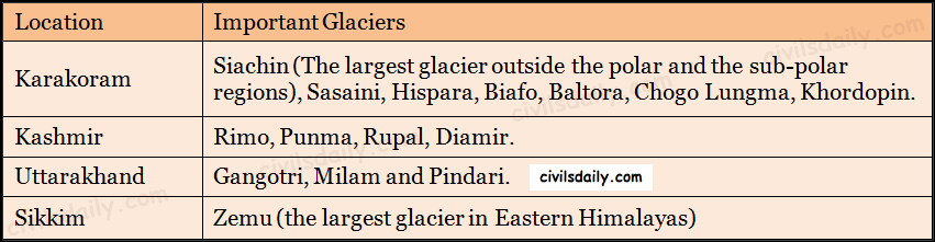
    • Glaciers: The main glaciers are found in the Great Himalayas and the Trans-Himalayan ranges (Karakoram, Ladakh and Zaskar). The Lesser Himalayas have small glaciers, though traces of large glaciers are found in the Pir Panjal and Dhauladhar ranges. Some of the important glaciers are:
    Important Glaciers and their Locations

    Key differences between the Eastern and Western Himalayas:

    Key Difference between the Western and Eastern Himalayas.

    Important Passes in India:

    A pass is a narrow gap in a mountain range which provides a passageway through the barrier.

    Important Passes in India
    • Pir Panjal Pass – It provides the shortest and the easiest metal road between Jammu and the Kashmir Valley. But this route had to be closed down as a result of partition of the subcontinent.
    • Banihal Pass – It is in Jammu and Kashmir. The road from Jammu to Srinagar transversed Banihal Pass until 1956 when Jawahar Tunnel was constructed under the pass. The road now passes through the tunnel and the Banihal Pass is no longer used for road transport.
    • Zoji La (Pass) – It is in the Zaskar range of Jammu and Kashmir. The land route from Srinagar to Leh goes through this pass.
    • Shipki La (Pass) – It is in Himachal Pradesh. The road from Shimla to Tibet goes through this pass. The Satluj river flows through this pass.
    • Bara Lacha Pass – It is also in Himachal Pradesh. It links Mandi and Leh by road.
    • Rohtang Pass – It is also in Himachal Pradesh. It cuts through the Pir Panjal range. It links Manali and Leh by road.
    • Niti Pass – It is in Uttarakhand. The road to the Kailash and the Manasarovar passes through it.
    • Nathu La (Pass) – It is in Sikkim. It gives way to Tibet from Darjeeling and Chumbi valley. The Chumbi river flows through this pass.
    • Jalep La (Pass) – At the tri-junction of India- China-Bhutan. The Teesta river has created this pass.

    B) The North-Eastern Hills and Mountains

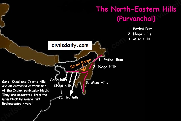
    The North-Eastern Hills (Purvanchal): Patkai Bum, Naga Hills, Mizo Hills

    The Brahmaputra marks the eastern border of Himalayas. Beyond the Dihang gorge, the Himalayas bend sharply towards south and form the Eastern hills or Purvanchal.

    • These hills run through the northeastern states of India.
    • These hills differ in scale and relief but stem from the Himalayan orogeny.
    • They are mostly composed of sandstones (i.e. Sedimentary rocks).
    • These hills are covered with dense forests.
    • Their elevation decreases from north to south. Although comparatively low, these hill ranges are rather forbidding because of the rough terrain, dense forests and swift streams.
    • Purvanchal hills are convex to the west.
    • These hills are composed of:
      • Patkai Bum – Border between Arunachal Pradesh and Myanmar
      • Naga Hills
      • Manipuri Hills – Border between Manipur and Myanmar
      • Mizo Hills.
    • Patkai Bum and Naga Hills form the watershed between India and Myanmar.
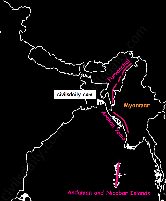
    • Extension of Purvanchal continues in Myanmar as Arakan Yoma –then Andaman and Nicobar Islands.
    Arakan Yoma – An Extension of Purvanchal in Myanmar

    The importance of Himalayan Region:

    • Climatic Influence – The altitude of the Himalayas, their sprawl and extension intercept the summer monsoon. They also prevent the cold Siberian air masses from entering into India. The climatic influence of the Himalayas will be dealt in detail in the next articles.
    • Defence
    • Source of perennial rivers
    • Source of fertile soils
    • Generation of hydroelectricity
    • Forest wealth
    • Orchards
    • Minerals – The Himalayan region is rich in minerals e.g. gold, silver, copper, lead etc. are known to occur. Coal is found in Kashmir. But at present level of technological advancement, it is not possible to extract these minerals. Also, it is not economically viable.
    • Tourism
    • Pilgrimage

    Now that we are done with this part, let’s try to attempt some questions from the past UPSC examinations:

    Prelims:

    2012:

    Question: When you travel in Himalayas, you will see the following:

    1. Deep gorges
    2. U-turn river courses
    3. Parallel mountain ranges
    4. Steep gradients causing land sliding

    Which of the above can be said to be evidences for Himalayas being young fold mountains?

    1. 1 and 2 only
    2. 1, 2 and 4 only
    3. 3 and 4 only
    4. 1, 2, 3 and 4

    Ans. D

    2003

    Question: Nanda Devi peak forms part of:

    A. Assam Himalayas

    B. Kumaon Himalayas

    C. Nepal Himalayas

    D. Punjab Himalayas

    Ans. B [Nandadevi – Uttarakhand]

    1997

    Question: Examine the map of Jammu and Kashmir given below

    camscanner-new-document-10-830920d00b40f30g00b50t10-002

    The mountain ranges marked 1, 2, 3 and 4 are respectively:

    a) Ladakh, Zaskar, Karakoram and Pir Panjal

    b) Karakoram, Ladakh, Zaskar and Pir Panjal

    c) Karakoram, Zaskar, Pir Panjal and Ladakh

    d) Ladakh, Pir Panjal, Karakoram and Zaskar

    Ans. B

    1995

    Question: The alpine vegetation in western Himalayas is found only upto a height of 3000m while in Eastern Himalayas it is found upto a height of 4000m. The reason for this variation in same mountain range is that:

    A. Eastern Himalayas are higher than western Himalayas

    B. Eastern Himalayas are nearer to equator and sea than Western Himalayas

    C. Eastern Himalayas get more rainfall than western Himalayas

    D. Eastern Himalayan rocks are more fertile than western Himalayas

    Ans. C

    Question: The Indian subcontinent was originally a part of a huge mass called

    A. Jurassic landmass

    B. Aryavarta

    C. Indiana

    D. Gondwana continent

    Ans. D

    Question: Arakan Yoma, the extension of the Himalayas is located in

    A. Baluchistan

    B. Myanmar

    C. Nepal

    D. Kashmir

    Ans. B

    Mains:

    • Write a short note on Karewas. (2marks 2005)
    • Bring out the causes for more frequent occurrence of landslides in the Himalayas than in the Western Ghats. (10 marks 2013)