Mains Ready By December. Smash Mains & Smash PYQ Admissions Open

Category: Ranker Webinars

  • Part 5 | Indian Soils – Arid, Saline and Alkaline, Peaty and Forest Soils

    We discussed in detail alluvial, black, red and laterite soils. Let’s continue the discussion and move on to the next soil types!
    Source

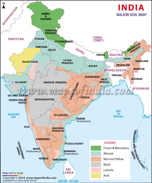
    5. Arid Soils

    • Formation: These are derived from the disintegration of adjacent rocks and are largely blown from coastal regions and Indus valley.
    • Areas: Arid soils are characteristically developed in western Rajasthan, which exhibit characteristic arid topography.
    • Soil Colour: Arid soils range from red to brown in colour.
    • Soil Texture: They are generally sandy to gravelly in texture and have a high percentage of soluble salts.
    • Other characteristic features:
      • These are saline in nature. In some areas, the salt content is so high that common salt is obtained by evaporating the saline water.
      • Due to the dry climate, high temperature and accelerated evaporation, they lack moisture and humus.
      • These soils are deficient in nitrogen and humus. The phosphate and iron content is normal. These soils are rich in minerals but the main limitation is the lack of water.
      • The soils exhibit poorly developed horizons.
      • Plants are widely spaced.
      • Chemical weathering is limited.
      • Lower horizons of the soil are occupied by ‘kankar’ layers because of the increasing calcium content downwards. The ‘Kankar’ layer formation in the bottom horizons restricts the infiltration of water, and as such when irrigation is made available, the soil moisture is readily available for a sustainable plant growth.
    • Suitable crops: If irrigated these soils give high agricultural returns. The availability of water from the Indira Gandhi canal has transformed the agricultural landscape of desert soils of western Rajasthan. These soils are mainly devoted to bajra, pulses, guar, fodder and less water requiring crops.

    6. Saline and Alkaline Soils

    • They are also known as Usara soils. Various local names for saline soils are Reh, Kallar, and Chopan, Rakar, Thur, Karl etc.
    • Formation:
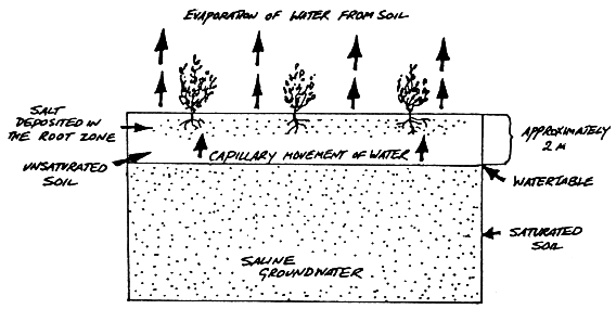
      • These soils have developed in areas with dry climatic conditions (in areas having a little more rainfall than the areas of desert soils) accompanied by lack of proper drainage. In this situation, salts of sodium, calcium and magnesium are deposited on the upper layer of the soil by capillary action.
        Source

      • In the Rann of Kuchchh, the Southwest Monsoon brings salt particles and deposits there as a crust.
      • These soils are also formed when saline water spreads on the land at the time of high tide in coastal areas. Also, seawater intrusions in the deltas promote the occurrence of saline soils.
      • Salinization also occurs because of over-irrigation (canal irrigation/groundwater use) and in areas of high water table (as in the coastal areas of Maharashtra and Tamil Nadu).Salinity from irrigation can occur over time wherever irrigation occurs. This is because almost all water (even natural rainfall) contains some dissolved salts. When the plants use the water, the salts are left behind in the soil and eventually begin to accumulate. Also, excessive irrigation with dry climatic conditions promotes capillary action, which results in the deposition of salt on the top layer of the soil (See the following figure).

        Source

      • These are thus, intrazonal soils.
    • Areas: They occur in arid and semi-arid regions, and in waterlogged and swampy areas. These are more widespread in western Gujarat, deltas of the eastern coast and in Sunderban areas of West Bengal.
    • Soil Texture: Their texture ranges from sandy to loamy.
    • Other characteristic features:
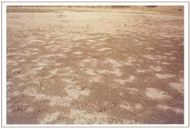
      • Because of capillary action, the salts are sucked up in solution to the surface and form white encrustations on the surface (See the picture below).
        Source

      • The salt efflorescence of calcium, magnesium and sodium makes these soils infertile.
      • Saline soils contain an excess of neutral soluble salts of chlorides and sulphates whereas sodic or alkali soils contain sodium carbonates/ sodium bicarbonates.
      • They lack in nitrogen and calcium and have low water bearing capacity.
      • These soils can be reclaimed by improving drainage, by applying gypsum and/or lime, and by cultivating salt resistant crops like barseem, dhaincha and other leguminous crops.
      • The saline and alkaline soils may occur in any group of soils.
    • Crops grown: In coastal areas, coconut trees are found in plenty in these soils. As discussed above, cultivating salt resistant crops like barseem, dhaincha and other leguminous crops can help in reclaiming these soils.
    • Note: In the areas of intensive cultivation with excessive use of irrigation, especially in areas of green revolution, the fertile alluvial soils are becoming saline. In such areas, especially in Punjab and Haryana, farmers are advised to add gypsum to solve the problem of salinity in the soil.

    7. Peaty Soils

    • These soils are locally called Kari in Kottayam and Alleppey districts of Kerala.
    • Formation: These are marshy soils and are a result of water logging and anaerobic conditions (which leads to partial decomposition of organic matter).
    • Areas: They are found in the areas of heavy rainfall and high humidity, where there is a good growth of vegetation. It occurs widely in the northern part of Bihar, the southern part of Uttaranchal and the coastal areas of West Bengal, Orissa and Tamil Nadu.
    • Soil Colour and Texture: These soils are normally heavy and black in colour
    • Other characteristic features:
      • These soils are characterised by a rich humus and organic content.
      • There is a presence of iron and varying amounts of organic matter (10-40%). The organic matter in these soils may go even up to 40-50 per cent.
      • These soils are generally acidic in nature. But at many places, they are alkaline also.
    • Suitable crops: These are generally submerged during the rainy season and utilised for the cultivation of rice.

    8. Forest Soils

    • Formation: As the name suggests, forest soils are formed in the forest areas where sufficient rainfall is available.
    • Areas: These are found in the forest areas of Himalayas, Sahyadris, Eastern Ghats and terai region.
    • Soil colour and texture: The soils vary in structure and texture depending on the mountain environment where they are formed. They are loamy and silty on valley sides and coarse-grained in the upper slopes. Their colour is dark brown.
    • Other Characteristics:
      • In the snow-bound areas of the Himalayas, they are acidic with low humus content. This is because humus is rawer at higher levels. Also, these soils are subjected to denudation due to landslides and snowfall.
      • The soils found in the lower valleys are fertile and rich in organic content.
      • Owing to sharp differences of hill slopes and climates, these soils may differ greatly even when in proximity. [Recall here the discussion on the impact of topography on soils!]
      • Also, these soils exist in thin layers because of their development on the mountain slopes.
      • These soils are poor in potash, phosphorus and lime.
      • Soil erosion is a major problem in these areas.
    • Crops grown: The slopes are used for horticulture and plantations crops like tea, coffee, spices, apple, peach etc. Rice and wheat are grown in valleys. Potatoes are grown in mostly all areas.

    Now that we are done with all the soil types, expand the following image for a quick revision!
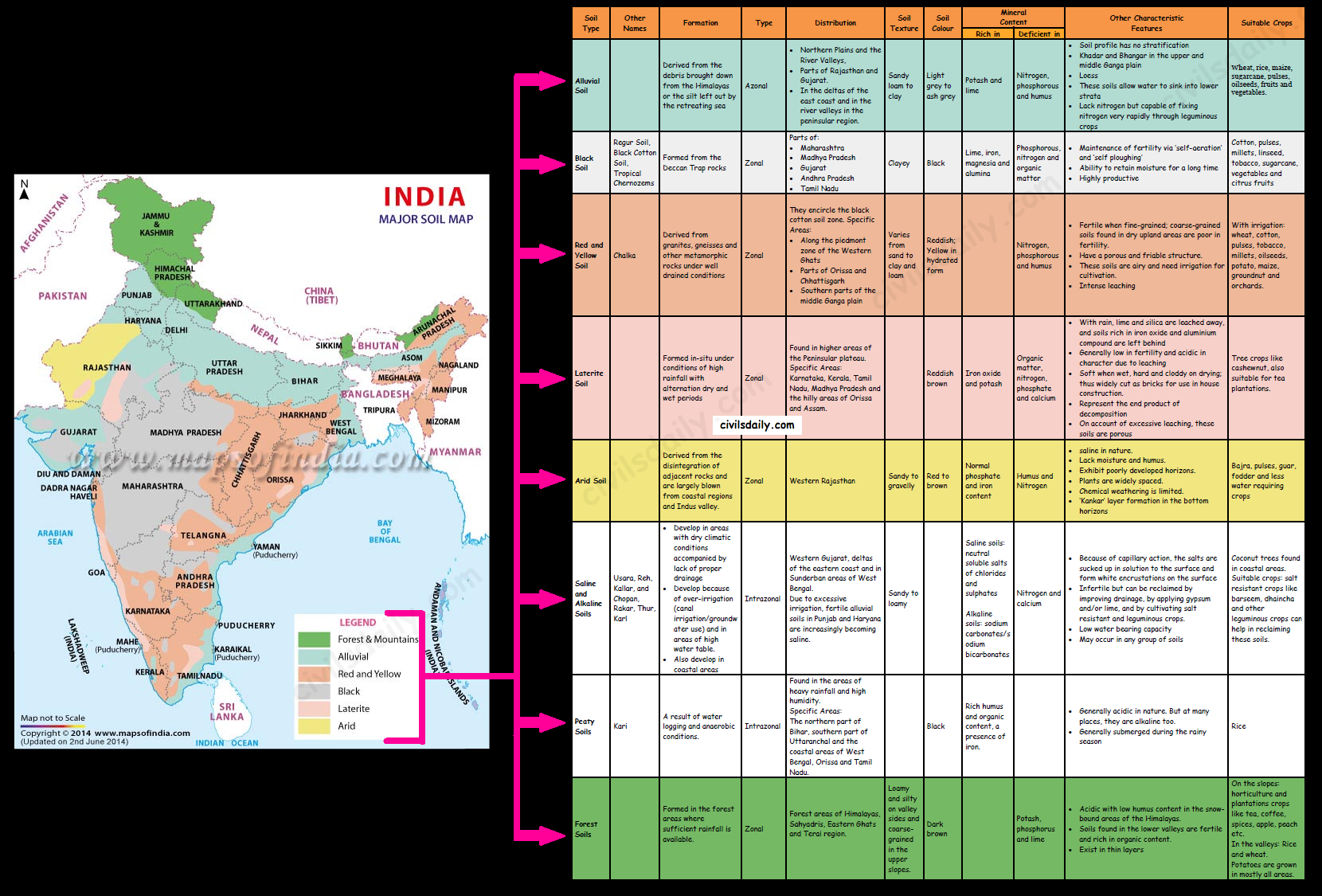
    Major Soil Types of India (Classification by ICAR)
  • Part 4 | Indian Soils – Alluvial, Black, Red and Laterite soils

    We learnt about the various ways to classify soils. In this article, we will look at the various types of Indian soils in detail (According to ICAR’s classification). Let’s begin!

    Source

    1. Alluvial Soils

    • Formation: They are mainly derived from the debris brought down from the Himalayas or the silt left out by the retreating sea. Thus they are azonal soils.
    • Areas: Alluvial soils are widespread in the northern plains and the river valleys. Through a narrow corridor in Rajasthan, they extend into the plains of Gujarat. In the Peninsular region, they are found in deltas of the east coast and in the river valleys.
    • Soil texture: The alluvial soils vary in nature from sandy loam to clay. These soils are more loamy and clayey in the lower and middle Ganga plain and the Brahmaputra valley. The sand content decreases from the west to east.
    • Soil Colour: The colour of the alluvial soils varies from the light grey to ash grey depending on the depth of the deposition, the texture of the materials, and the time taken for attaining maturity.
    • Other Characteristic Features:
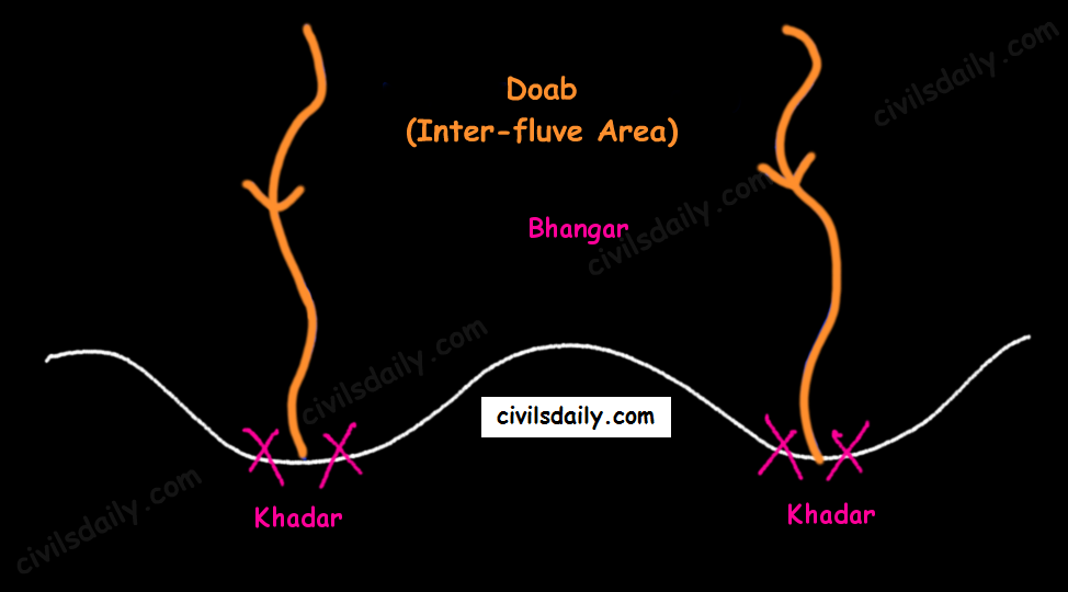
      • In the Upper and Middle Ganga plain, two different types of alluvial soils have developed, viz. Khadar and Bhangar.
    Khadar and Bhangar
      • Khadar: the newer alluvium deposited by floods annually, enriches the soil by depositing fine silts, light colour, found near river beds, porous in nature.Bhangar: older alluvium, clayey, darker, has lime nodules called Kankars, found in doabs (inter-fluve areas).
      • Alluvial soils of the northern plains —> transported soils —> therefore lack humus —> lack nitrogen [That is why we need to use nitrogenous fertilisers in the northern plains!]. Exception: the Ganga-Brahmaputra delta region is rich in humus.
      • These soils lack in nitrogen, phosphorus and humus. However, they are generally rich in potash and lime.
      • The soil profile has no stratification.
      • Alluvial soils are intensively cultivated.
      • In certain areas, these soils are covered with unproductive wind-borne soil called Loess.
    • Limitations:
      • Allow water to sink into lower strata, and
      • Lack nitrogen (But these soils are capable of fixing nitrogen very rapidly through leguminous crops (peas, beans, cloves etc.)
    • Suitable Crops: Wheat, rice, maize, sugarcane, pulses, oilseeds, fruits and vegetables, leguminous crops.

    2. Black Soil

    • These soils are locally known as the ‘Regur Soil’ or the ‘Black Cotton Soil’. Internationally, these are known as ‘tropical chernozems’. These soils are famous for the cultivation of cotton.
    • Formation: These have mainly formed from the Deccan Trap rocks —> Zonal Soils
    • Areas: These are found in the Deccan trap region. Black soil covers most of the Deccan Plateau which includes parts of:
      • Maharashtra,
      • Madhya Pradesh,
      • Gujarat,
      • Andhra Pradesh and some parts of
      • Tamil Nadu.
    • Soil Texture: Black cotton soil (regur soil) is highly argillaceous i.e. clayey. It is deep and impermeable and thus has high water retention capacity.
    • Soil Colour: These soils are black in colour due to the presence of iron, aluminium compounds and humus.
    • Other Characteristic Features:
      • These soils are rich in minerals and known for their fertility.
      • The soil depth varies from place to place. It is very thick in lowlands but very thin on highlands. Also, in the upper reaches of the Godavari and the Krishna, and the northwestern part of the Deccan Plateau, the black soil is very deep.
      • These soils swell and become sticky when wet and develop deep wide cracks when dry. This helps in self-aeration, which leads to absorption of nitrogen from atmosphere. Thus, there occurs a kind of ‘self ploughing’. This aeration and oxidisation to deep levels contributes to maintenance of fertility of these soils. This continued fertility is favourable in the area of low rainfall for cotton cultivation even without irrigation.
      • Due to slow absorption and loss of moisture, the black soil retains the moisture for a very long time, which helps the crops, especially, the rain fed ones, to sustain even during the dry season.
      • Chemically, the black soils are rich in lime, iron, magnesia and alumina. They also contain potash. But they lack in phosphorous, nitrogen and organic matter.
    • Suitable Crops: These soils are highly productive and well suited to the cultivation of cotton, pulses, millets, linseed, tobacco, sugarcane, vegetables and citrus fruits.

    Note: In the southern and eastern parts of the country where rainfall is heavy, black soils often occur in close proximity to red soils. Black soils occupy valleys and low-level areas whereas the red soils occur on higher slopes and hill tops. Mixed black and red soils occur in Coimbatore, Madurai, Tirunelveli (Tamil Nadu) and Bundelkhand region.

    3. Red and Yellow Soils

    • Locally called ‘Chalka’ in Andhra Pradesh.
    • Formation: These are derived from granites, gneisses and other metamorphic rocks —> Zonal Soils. These are formed under well-drained conditions.
    • Areas: Along the piedmont zone of the Western Ghat, a long stretch of area is occupied by red loamy soil. Yellow and red soils are also found in parts of Orissa and Chattisgarh and in the southern parts of the middle Ganga plain. They encircle the black cotton soil zone.
    • Soil Colour: The soil develops a reddish colour due to a wide diffusion of iron in crystalline and metamorphic rocks. It looks yellow when it occurs in a hydrated form. Often, their upper layer is red and the lower layer is yellow.
    • Soil Texture: Varies from sand to clay and loam.
    • Other Characteristic Features:
      • The fine-grained red and yellow soils are normally fertile, whereas coarse-grained soils found in dry upland areas are poor in fertility.
      • Have a porous and friable structure.
      • They are generally poor in nitrogen, phosphorous and humus.
      • These soils are airy and need irrigation for cultivation.
      • Intense leaching is a menace in these soil areas.
    • Suitable Crops: In places where irrigation facilities are available, the crops cultivated are wheat, cotton, pulses, tobacco, millets, oilseeds, potato, maize, groundnut and orchards.

    4. Laterite Soil

    • The word laterite has been derived from the Latin word ‘Later’ which means brick. These soils when wet are as soft as butter but become hard and cloddy on drying. Therefore, these are widely cut as bricks for use in house construction.
    • Formation: The lateritic soils are particularly found on high flat erosion surfaces in areas of high(>200cm) and seasonal rainfall. The alternating wet and dry seasons lead to the leaching away of the siliceous matter of the rocks leaving behind the compounds of iron and aluminium. These are zonal soils.
    • Areas: These soils have mainly developed in the higher areas of the Peninsular plateau. The laterite soils are commonly found in Karnataka, Kerala, Tamil Nadu, Madhya Pradesh and the hilly areas of Orissa and Assam.
    • Soil Colour: Reddish brown in colour due to the presence of iron oxide.
    • Other characteristic features:
      • With rain, lime and silica are leached away, and soils rich in iron oxide and aluminium compound are left behind(thus the reddish brown colour). Also, humus content of the soil is removed fast by bacteria that thrives well in high temperature.
      • These soils represent the end product of decomposition and are generally low in fertility.
      • The pebbly crust is the important feature of laterites which is formed due to alteration of wet and dry periods.
      • These soils are acidic in character due to leaching. Application of manures and fertilisers is required for making these soils fertile for cultivation.
      • These soils are poor in organic matter, nitrogen, phosphate and calcium, while iron oxide and potash are in excess.
    • Suitable crops: Red laterite soils in Tamil Nadu, Andhra Pradesh and Kerala are more suitable for tree crops like cashewnut. These soils are also suitable for tea plantations.

    That’s it for this part!

  • Natural Vegetation and Wildlife: Part 6 | Conservation of Wildlife

    Conservation of Wildlife:

    1. The Government of India enacted Wild Life (Protection) Act 1972 with the objective of effectively protecting the wild life of this country and to control poaching, smuggling and illegal trade in wildlife and its derivatives.

    • The act extends to the whole of India except J&K which has its own wildlife act.
    • It has 6 schedules which give varying degrees of protection.
      • Schedule I and part II of Schedule II provide absolute protection and offences under these are prescribed the highest penalties.
      • The penalties for Schedule III and Schedule IV are less and these animals are protected.
      • Schedule V includes the animals which may be hunted. These are the Common crow, Fruit bats, Mice & Rats only.
      • Schedule VI contains the plants, which are prohibited from cultivation and planting.

    2. A National Board for Wildlife (NBWL), chaired by the Prime Minister of India provides for policy framework for wildlife conservation in the country.

    3. The National Wildlife Action Plan (2002-2016) was adopted in 2002, emphasizing the people’s participation and their support for wildlife conservation. The Draft National Wildlife Action Plan (NWAP) 2017-31 envisages 17 focus areas, including a new area linking wildlife planning to climate change.

    4. The Indian Constitution entails the subject of forests and wildlife in the Concurrent list thus laying the responsibility of wildlife conservation on both the Centre and the State. The Federal Ministry acts as a guiding torch dealing with the policies and planning on wildlife conservation, while the provincial Forest Departments are vested with the responsibility of implementation of national policies and plans.

    5. Specialized projects: To save the endangered species of animals, specialised projects are being implemented with international cooperation (WWF, UNDP, UNEP, IUCN) as well as on a stand-alone basis e.g.

    • Project Tiger 1973 [Follow the news story here for latest developments]
    • Operation Crocodile 1975
    • Project Rhinoceros 1987
    • Project Snow Leopard
    • Project Elephant 1988

    More recently, the Black Buck (chinkara), the Great Indian Bustard (godawan) and the snow leopard etc. have been given full or partial legal protection against hunting and trade throughout India.

    6. The Protected Areas of India:

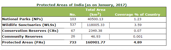
    Protected areas are those in which human occupation or at least the exploitation of resources is limited. These are defined according to the categorization guidelines for protected areas by the International Union for Conservation of Nature (IUCN). There are several kinds of protected areas, which vary by level of protection depending on the enabling laws of each country or the regulations of the international organizations involved.

    There are 4 categories of the Protected Areas in India viz,

    • National Parks,
    • Sanctuaries,
    • Conservation Reserves, and
    • Community Reserves.

    Source

    Let’s look at these in detail:

    • National Park:
      • A National park is an area with enough ecological, geo-morphological and natural significance with rich fauna and flora, which is designed to protect and to develop wildlife or its environment.
      • National parks in India are IUCN category II protected areas.
      • Activities like grazing, hunting, forestry or cultivation etc. are strictly prohibited. No human activity is permitted inside the national park except for the ones permitted by the Chief Wildlife Warden of the state.
      • India’s first national park was established in 1936 as Hailey National Park, now known as Jim Corbett National Park, Uttarakhand.
      • There are 103 existing national parks in India covering an area of 40,500 km2, which is 1.23% of the geographical area of the country (National Wildlife Database, April 2015). [For a complete list of national parks in India and their associated fauna, click here.]
    • Wildlife Sanctuary:
      • Any area other than area comprised with any reserve forest or the territorial waters can be notified by the State Government to constitute as a sanctuary if such area is of adequate ecological, faunal, floral, geomorphological, natural. or zoological significance, for the purpose of protecting, propagating or developing wildlife or its environment.
      • The difference between a Sanctuary and a National Park mainly lies in the vesting of rights of people living inside. Unlike a Sanctuary, where certain rights can be allowed, in a National Park, no rights are allowed. No grazing of any livestock is permitted inside a National Park while in a Sanctuary, the Chief Wildlife Warden may regulate, control or prohibit it.
      • There are a total of 537 wildlife sanctuaries in India.
    • Conservation reserves and community reserves in India:
      • These terms denote the protected areas of India which typically act as buffer zones to or connectors and migration corridors between established national parks, wildlife sanctuaries and reserved and protected forests of India.
      • Such areas are designated as Conservation Reserves if they are uninhabited and completely owned by the Government of India but used for subsistence by communities and Community Reserves if a part of the lands is privately owned.
      • These protected area categories were first introduced in the Wildlife (Protection) Amendment Act of 2002 − the amendment to the Wildlife Protection Act of 1972.
      • These categories were added because of reduced protection in and around existing or proposed protected areas due to private ownership of land, and land use.

    7. Biosphere Reserves: A biosphere reserve is an area of land or water that is protected by law in order to support the conservation of ecosystems, as well as the sustainability of mankind’s impact on the environment.

    • Each reserve aims to help scientists and the environmental community figure out how to protect the world’s plant and animal species while dealing with a growing population and its resource needs.
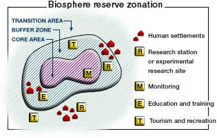
    • To carry out the complementary activities of biodiversity conservation and sustainable use of natural resources, biosphere reserves are traditionally organized into 3 interrelated zones, known as:
      • the core area,
      • the buffer zone, and
      • a transition zone or ‘area of cooperation.

    Source

    • The purpose of the formation of the biosphere reserve is to conserve in situ all forms of life, along with its support system, in its totality, so that it could serve as a referral system for monitoring and evaluating changes in natural ecosystems.
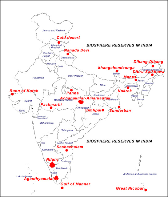
    • Presently, there are 18 notified biosphere reserves in India. Ten out of the eighteen biosphere reserves are a part of the World Network of Biosphere Reserves, based on the UNESCO Man and the Biosphere (MAB) Programme list. [Related Reading: Everything about biosphere reserves explained here. A complete list of biosphere reserves in India and their fauna types can be found here!]

    Source

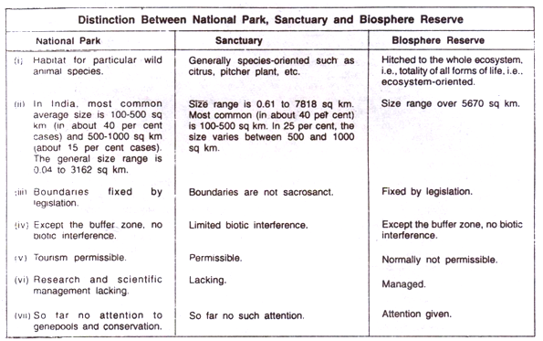
    How is a biosphere reserve different from a national park/ wildlife sanctuary?

    Biosphere Reserves of India protect larger areas of natural habitat (than a National Park or Wildlife Sanctuary). Biosphere Reserves may cover multiple National Parks, Sanctuaries and reserves as well.

    Ex. the Nilgiri Biosphere covers: Bandipur National park, Mudumalai Tiger Reserve, Silent Valley National Park, Nagarhole National Park, Mukurthi National Park and is usually a contiguous area.

    Some of the other differences are listed in the image below:

    Source

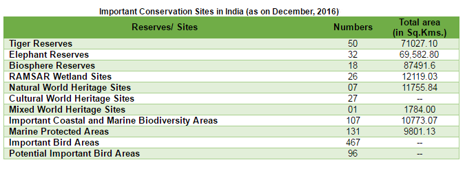
    8. Some other important Conservation Sites:

    • Tiger reserves – Project Tiger was launched by the Government of India in the year 1973 to save the endangered species of tiger in the country. Starting from nine (9) reserves in 1973 the number has now grown up to fifty (50) in 2016.
    • Elephant reserves
    • RAMSAR Wetland Sites [Related Reading: Everything that you need to know about Wetlands, A complete list of RAMSAR wetland sites in India can be found here]
    • UNESCO World Heritage Sites (Natural, Cultural and Mixed) – Places listed by the United Nations Educational, Scientific and Cultural Organization as of special cultural or physical significance.
    • Marine Protected Areas
    • Important Bird Areas

    Source

    9. Role of communities: Communities have played a vital role in the conservation and protection of wildlife in India. E.g.

    • Sariska Tiger Reserve: In Sariska tiger reserve Rajasthan villagers have fought against mining by citing the wildlife protection act. In many areas, villagers themselves are protecting habitats and explicitly rejecting government involvement.
    • Bhairodev Dakav Sonchuri: The inhabitants of five villages in the Alwar district of Rajasthan have declared 1200 hectares of forests as the Bhairodev Dakav Sonchuri declaring their own set of riles and regulation which do not allow hunting, and are protecting the wildlife against any outside encroachments.
    • Bishnoi villages: In and around Bishnoi villages in Rajasthan, herds of blackbuck, Nilgai and peacocks can be seen as an integral part of the community and nobody harms them.
  • Natural Vegetation and Wildlife: Part 5 | Conservation of Forests – Afforestation Schemes and Other Initiatives

    In this article, we continue the discussion and look at various conservation attempts made to protect the Indian forests.

    Conservation of Forests:

    1. The National Forest Policy:

    • The National Forest Policy 1952 aimed at bringing one-third of the total land area with 65% in hilly and 25% in plains under the forest cover. It suggested the extension of tree lands on river/canal banks, roads, railways, cultivable waste and degraded lands.
    • A new forest policy was adopted in 1988 the main emphasis of which was on the protection, conservation, regeneration, and development of forests.

    2. Social Forestry:

    • The term, social forestry, was first used in India in 1976 by The National Commission on Agriculture. It was then that India embarked upon a social forestry project with the objective of taking the pressure off the traditional forests by the plantation of fuelwood, fodder, timber and grasses on unused and fallow land.
    • What social forestry means – Social Forestry refers to the forests (trees) planted by the people of a society. It has been defined as ‘the forestry of the people, for the people, by the people’.

    Although a wide range of activities are included in social forestry, these mainly have the following components:

    • Agro Forestry – Encouraging Farmers to plant trees on their farms. Read more about it here.
    • Extension Forestry – Woodlots planted by forest departments for the needs of the community especially along roads, canals, railways, and other public lands
    • Community Forestry – Trees planted by the community themselves, on community lands, to be shared equally by them.
    • Reforestation or rehabilitation of degraded forest areas.

    The social forestry projects, however, failed because:

    • They did not involve women who were the main beneficiaries.
    • Market-oriented trees were planted. Thus communities and farmers saw it as a cash generating rather than basic need generating exercise. The wood ended up for urban and industrial use rather than fuel and fodder needs of the rural people.
    • Agro-forestry reduced land employment while absentee landlordism increased.

    3. Several laws have been passed by legislatures to regulate the use of forests, ban on cutting of trees and encroachment on forest lands:

    • Forest Conservation Act, 1980 was passed for reserved forest areas.
    • Environmental Protection Act gave the Central Government powers to protect and improve the quality of the environment and preventing pollution.
    • The Scheduled Tribes and Other Traditional Forest Dwellers (Recognition of Forest Rights) Act, 2006, recognises the rights of forest-dwelling Scheduled Tribes and other traditional forest dwellers over the forest areas inhabited by them and provides a framework for according the same.

    [Related Reading: Evolution of Forest Rights in India from 1856 to 2006 | In Depth Analysis of FRA & Its Issues]

    Besides, international conventions like Reducing Emissions through Deforestation and Degradation plus (REDD+) help to set guidelines.

    4. At present there are two major afforestation schemes namely:

    • National Afforestation Programme – NAP (Aimed at afforestation and eco-restoration of degraded forests and adjoining areas with emphasis on community participation)
    • National Mission for a Green India (Aimed at increasing the forest cover of country along with improving its quality)
      • Commonly called the Green India Mission (GIM)
      • Launched in February 2014
      • It is one of the eight Missions outlined under India’s action plan for addressing the challenge of climate change -the National Action Plan on Climate Change (NAPCC). GIM.
      • There is a component under GIM to support forestry on farm lands for taking up Agro-forestry and Social forestry.

    [Note: Generally a “mission mode” project implies a project that has clearly defined objectives, scopes, implementation timelines and milestones, as well as measurable outcomes and service levels.]

    5. Other Government Initiatives:

    • National Green Highways Mission
      • Launched in July 2016
      • The mission aims to provide a green canopy along 100,000km of highways and create jobs for 1 million youth.
      • Under the mission, the government has made it mandatory to set aside 1% of the total project cost of any national highway contract to a Green Fund for plantation.
    • Nagar Van-udyan Yojana
      • A programme for climate smart green cities.
      • It is a Pilot scheme recently launched for implementation for a period of five Years.
      • The scheme aims at developing 200 Nagar Van (City Forests) across the country in cities having Municipal Corporation or Municipalities.
      • A Nagar Van-Udyan is a forested area in the vicinity of a city accessible to the city dwellers suitably managed for providing a wholesome natural environment for recreation, conservation education, biodiversity conservation etc.
    • School Nursery Yojana
      • It seeks to bring students closer to nature and inculcate in them a sense of urgency to protect the environment.
      • Under the scheme, students will sow seeds and grow saplings in the school nursery as part of their practical exercise for Biology classes or as their extra-curricular activities.
      • The students will also carry out a tree census in their school and the locality.

    Read more about the School Nursery Yojana here.

    6. The Role of communities: Communities have played a vital role in the conservation and protection of forests in India. E.g.

    • Chipko movement: – Chipko Movement, started in 1970’s, was a non-violent movement aimed at protection and conservation of trees and forests from being destroyed. The name of the Chipko moment originated from the word ’embrace’ as the villagers used to hug the trees and protect them from wood cutters from cutting them. This movement headed by Shri Sunderlal Bahaguna in the Himalayas not only successfully resisted deforestation in several areas but also showed that community afforestation with indigenous species can be enormously successful.
    • Appiko Movement – On the lines of Chipko movement, Pandurang Hegde launched the Appiko Movement in Karnataka in 1983 (Appiko – to express one’s affection for a tree by embracing it). Its objectives were afforestation as well as development, conservation and proper utilization of forests in the best manner.
    • Silent Valley Movement – The silent valley is an area of tropical evergreen forests in Kerala. It is among the last tracts of virgin tropical evergreen forest in India and is very rich in bio-diversity. The environmentalists and the local people strongly objected to the hydel power project being set up here in 1973. Under pressure, the government had to declare it a national reserve forest in 1985.
    • Joint forest management: – this programme furnishes a good example for involving local communities in the management and restoration of degraded forests. The programme has been in formal existence since 1988 when the state of Orissa passed the first resolution for joint forest management. JFM depends on the formation of local (village) institutions that undertake protection activities mostly on degrade forest land managed by the forest department. In return, the members of these communities are entitled to intermediary benefits like non – timber forests produce and share in the timber harvested by successful protection.
    • Certain societies revere a particular tree which they have preserved from time immemorial. E.g. the Mundas and the Santhals of Chhotanagpur region worship Mahua and Kadamba trees and the tubes of Orissa and Bihar worship theTamarind and many trees during weddings.
  • Natural Vegetation and Wildlife: Part 4 | Vegetation Zones of the Himalayas, The Problems of Indian Forestry

    The Himalayan ranges show a succession of vegetation from the tropical to the tundra, which changes with altitude. When we look at the vegetational zones, the eastern Himalayas are similar to the western Himalayas.

    But on the whole, the eastern Himalayas have more tropical elements, a greater variety of Oaks and Rhododendrons and less of conifers than the western Himalayas.

    Some other differences are:

    • The higher rainfall and warmer conditions in this part of the Himalayas.
    • Also, the tree line and the snow line are higher in the eastern Himalayas than the corresponding lines in the western Himalayas (Recall the discussion on snowline? Click here to quickly revise!).
    • Species diversity and vegetation density are also higher in the East.

    Also, the southern slopes of the Himalayas carry a thicker vegetation cover because of relatively higher precipitation than the drier north-facing slopes.

    Some other ways of classifying forests:

    1. Classification according to composition:

    • Coniferous Forests: These are temperate forests occupying about 6.50% of the total forest area of the country. These are confined to the Himalayan ranges and provide soft wood timber.
    • Broad-Leaved Forests: These are tropical and subtropical monsoon forests. These are widely spread and cover 94% of the total forest area of the country. These are found in the plains, plateaus and mountainous areas of the country. Sal, Teak and Bamboo are important varieties.

    2. Legal or Administrative Classification:

    Broadly speaking, reserved, protected and unclassed are the three major legal classes of forest in India. A legal notification in a government gazette under Indian Forest Act creates or defines the boundaries of “reserved and “protected” forests in India. These forests by definition are owned by government. The rest of forests areas or waste land or any other land “recorded” in land records as “forest” but not notified in government gazette as “reserved” or “protected” forests under Indian Forest Act, are called unclassed forests. The status of their ownership and control varies among various States in India.

    • Reserved Forests:
      • These forests are under the direct supervision of the government and no public entry is allowed for the collection of timber or grazing of cattle.
      • About 53 % of total forest area falls in this category.
      • Reserved forests are regarded as the most valuable as far as the conservation of forests and wildlife is concerned.
      • In such forests, most of the activities are prohibited unless allowed.
    • Protected Forests:
      • These forests are looked after by the government but the local people are allowed to collect fuelwood/timber and graze their cattle without causing serious damage to the forests.
      • These occupy 29% of the total forest area of the country.
      • In such forests, most of the activities are allowed unless prohibited.
    • Unclassed/Unclassified Forests:
      • There is no restriction on cutting of trees and cattle grazing.
      • These occupy 18% of the total forest area of the country.
      • These are the other forests and wastelands belonging to both government and private individuals and communities.
      • All north-eastern states and parts of Gujarat have a very high percentage of their forests as unclassed forests managed by local communities.

    Reserved and protected forests are referred to as permanent forest estates because they are maintained for the purpose of producing timber and other forest produce, and for protective reasons

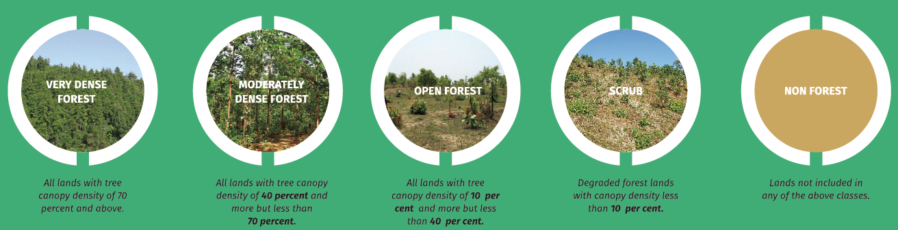
    3. The Forest Survey of India classifies forest cover in 4 classes:

    • Very Dense forest: All lands with tree cover (including mangrove cover) of canopy density of 70% and above.
    • Moderately dense forest: All lands with tree cover (including mangrove cover) of canopy density between 40% and 70%.
    • Open forests: All lands with tree cover (including mangrove cover) of canopy density between 10% and 40%.
    • Scrubs: All forest lands with poor tree growth mainly of small or stunted trees having canopy density less than 10%

    The moderately dense and very dense forests are called Prime forests. Non-Forests are the lands not included in any of the above classes.

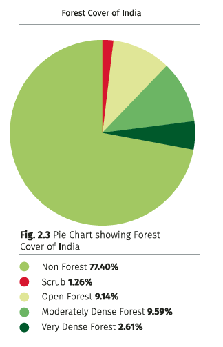
    Source – India State of Forest Report (ISFR) 2015

    Forest Cover in India:

    According to the India State of Forest Report 2015, forests cover 21.34% of the total geographical area of the country (Road more about the report here!).

    Some other facts:

    • Out of the total forest cover, the maximum share is of Moderate Dense Forests, followed by Open Forests.
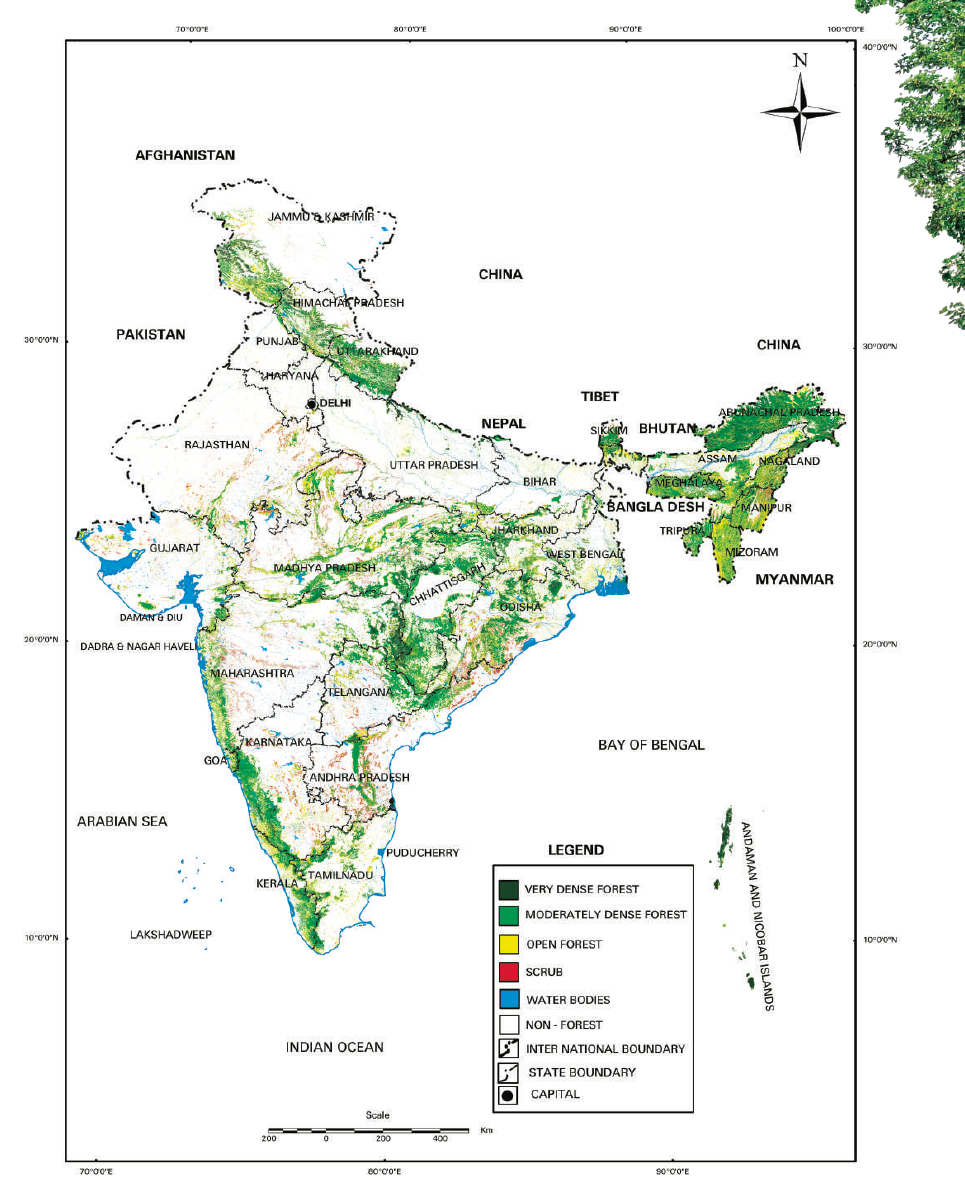
    • Also, Madhya Pradesh has the largest total forest cover, followed by Arunachal Pradesh and Chhattisgarh.
    • Mizoram, with 88.93 % of forest cover has the highest forest cover in percentage terms, followed by Lakshadweep.
    Source – India State of Forest Report (ISFR) 2015
    The Forest Cover map of India. Source: India State of Forest Report (ISFR) 2015

    The Problems of Indian Forestry:

    The specific problems of the Indian Forestry are the following:

    1. Low Forest Cover

    The forest cover in India is only 21.34% against the world average of about 35% and the stipulated 33% under the National Forest Policy 1952. The states of Punjab, Haryana and Rajasthan have less than 5% of their areas under forests. Forest area is decreasing due to deforestation on account of:

    • Growing demand for agricultural land.
    • Urbanisation and industrialisation
    • Construction of multipurpose projects
    • Commercial activities like mining, quarrying, oil extraction, orchard development etc.
    • Shifting cultivation – Increasing pressure of population has reduced the jhum cycle to only 5 years in many parts of Nagaland, Meghalaya, Mizoram, Tripura and Manipur. Consequently, the forests do not have sufficient time to regenerate.
    • Overgrazing by cattle
    • Transhumance i.e. seasonal migration by nomadic tribes up and down the mountains.

    2. Uneconomic utilisation of forests:

    • Most of the forests are not gregarious i.e. usable plants not growing close enough. This creates a problem in their exploitation.
    • 40% of the total forest area is inaccessible.
    • Lumbering, transport and sawing of timber is still done by primitive techniques.
    • Lack of scientific techniques of growing forests as in Canada, Russia. Only natural growth of forests takes place in India

    3. Forest Fires – Natural and manmade.

    4. Plant diseases, pests, insects

  • Natural Vegetation and Wildlife: Part 3 | The Sub-tropical, Temperate, Sub-Alpine and Alpine, Littoral and Swamp Vegetation

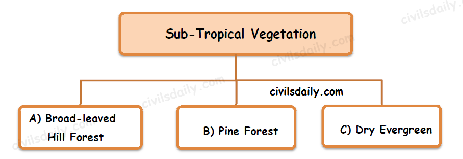
    4. Subtropical Vegetation

    A. Sub-tropical Broad-leaved Hill Forests:

    • Distribution: These forests occur on the lower slopes of the Himalaya in Bengal and Assam and on other hill ranges such as Khasi, Nilgiri, Mahabaleshwar, Pachmarhi, Amarkantak and Parasnath.
    • Important Species: In the eastern Himalayas, Oak, Chestnut, Ash, Birch, Pine are common species.

    B. Sub-tropical Pine Forest

    • Distribution: Subtropical chir pine forest occurs throughout the central and western Himalaya, and Khasi pine forest occurs in Khasi hills.
    • Important Species: In the western Himalayas Chir Pine is the most important tree while Oak occurs in the wetter areas. In drier areas of Kashmir (rainfall 50-100cm) wild Olives are common with varieties of scrub.
    • Chief Characteristics:
      1. These forests are almost pure throughout their zone of distribution.
      2. The understorey is also not pronounced.

    C. Sub-tropical Dry Evergreen Forest

    • Distribution: These forests occur in areas with low rainfall and consist of xerophytic, thorny and small-leaved evergreen species. Such forests are localised in the north-west corner of the country.

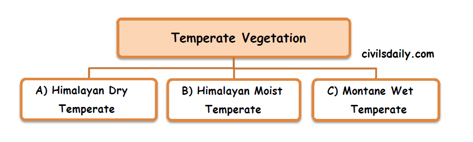
    5. Temperate Vegetation

    A. Himalayan Dry Temperate Vegetation

    • Distribution: It is found in the inner dry ranges of the western Himalayas.
    • Characteristic Features: It is predominantly a coniferous forest with xerophytic scrubs. Epiphytes and climbers are rare. [Coniferous trees are tall, straight with narrow needle like leaves. Most of the coniferous trees are evergreen but some like Larch are deciduous in nature]
    • Important Species are Chilgoza, Deodar, Oak, Maple, Ash, Olive etc.

    B. Himalayan Moist Temperate Vegetation

    • Distribution: In the western Himalayas between 1500m and 3000m.
    • Characteristic Features: The trees are 30 to 50m tall and undergrowth is mostly evergreen. Mosses and ferns grow freely on trees.
    • Important Species: Deodar, Spruce, Maple, Walnut, Poplar, Cedar, Chestnut, Birch, Oak etc.

    C. Montane Wet Temperate Vegetation

    • Distribution: In the eastern Himalayas, evergreen wet temperate forests occur between 1800m and 2700m of altitude. Nilgiris, the Annamalai and the Palni hills of south India also have this kind of forests above 1500m of altitude. The trees there are shorter, and the undergrowth is denser with abundance of epiphytes, mosses and ferns.
    • Characteristic Features: Rainfall is high, temperature is moderate in summer, and winter is cold. Rate of evaporation is not high. So trees do not shed their leaves annually, at least not at the same time.
    • Important Species: Oak, Poplar, Elm, Laurel, Maple, Birch, Alder, Magnolia

    6. Sub-Alpine and Alpine Vegetation

    • Distribution: It occurs above 2700m of altitude in the eastern Himalayas and above 3000m in the western Himalayas.
    • Important Species: It is a dense scrubby forest of Silver Fur, Juniper, Pine, Birch and Rhododendron.
    • Characteristic Features:
      1. The alpine forests give way to alpine grasslands through shrubs and scrub. These extend upwards up to the snowline.
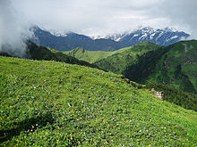
      2. Bugyals: Bugyals are high altitude alpine grasslands or meadows in Uttaranchal (at an elevation between 3400m and 4000m). These are referred to as ‘nature’s own gardens’. The topography of the terrain is either flat or sloped. The surface of these bugyals is covered with natural green grass and seasonal flowers. They are used by tribal herdsmen to graze their cattle. During the winter season the alpine meadows remain snow-covered. During summer months, the Bugyals present a riot of beautiful flowers and grass. Bugyals have a very fragile ecosystem. Some examples of Bugyals:
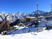
        • Auli (near Joshimath) – A premier skii range is located here.
        • Gorso
        • Kwanri Bugyal
        • Bedni
        • Panwali and Kush Kalyan
        • Dayara
        • Munsiyari Bugyal

    Auli Bugyal during summers

    Auli Bugyal during winters

    7. Littoral and Swamp Vegetation ( Mangrove Vegetation/ Tidal Forests)

    • Distribution: In the tidal deltas of Ganga, Mahanadi, Godavari and Krishna rivers, evergreen mangrove vegetation thrives. These areas have rainfall of more than 200cm.
    • Important Tree Species: Sundari, Agar, Bhendi, Keora, Nipa
    • Important Animal Species: Turtles, crocodiles, gharials and snakes are the common animals found in these forests. Royal Bengal Tiger is found in the tidal forests of Ganga delta.
    • Characteristic Features:
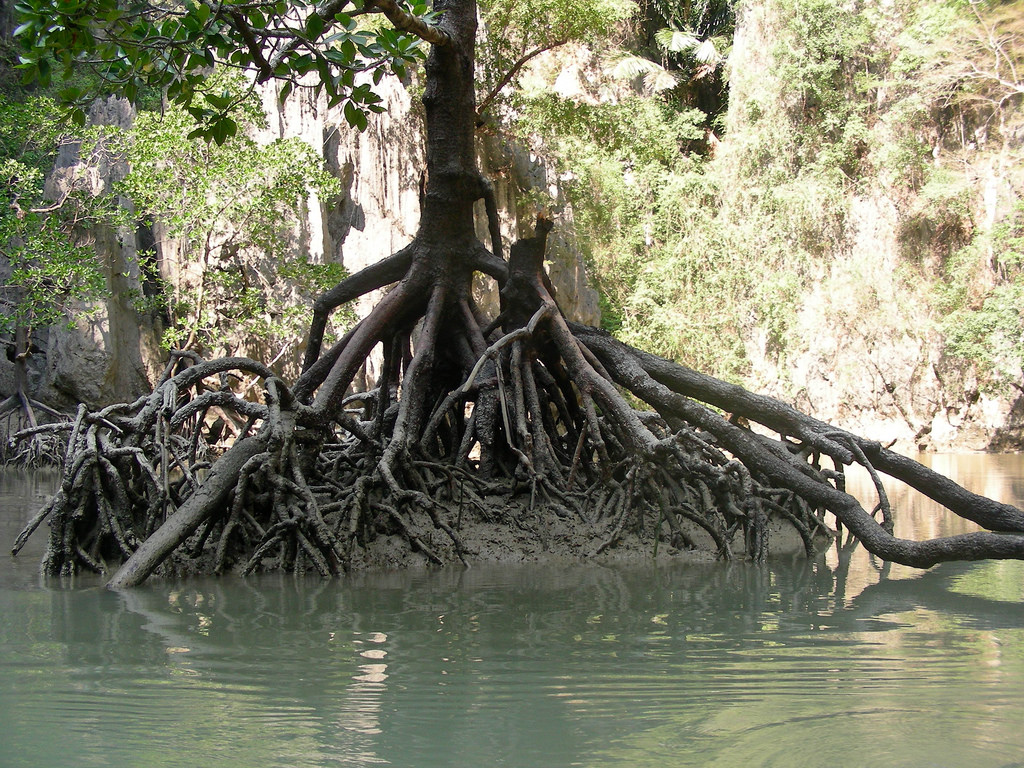
      • The trees are mainly evergreen. Typically they produce tangled webs of arching roots that are exposed during low tides.
      • This vegetation is an adaptation to two conditions:
        • High water salinity
        • Flooded at regular intervals
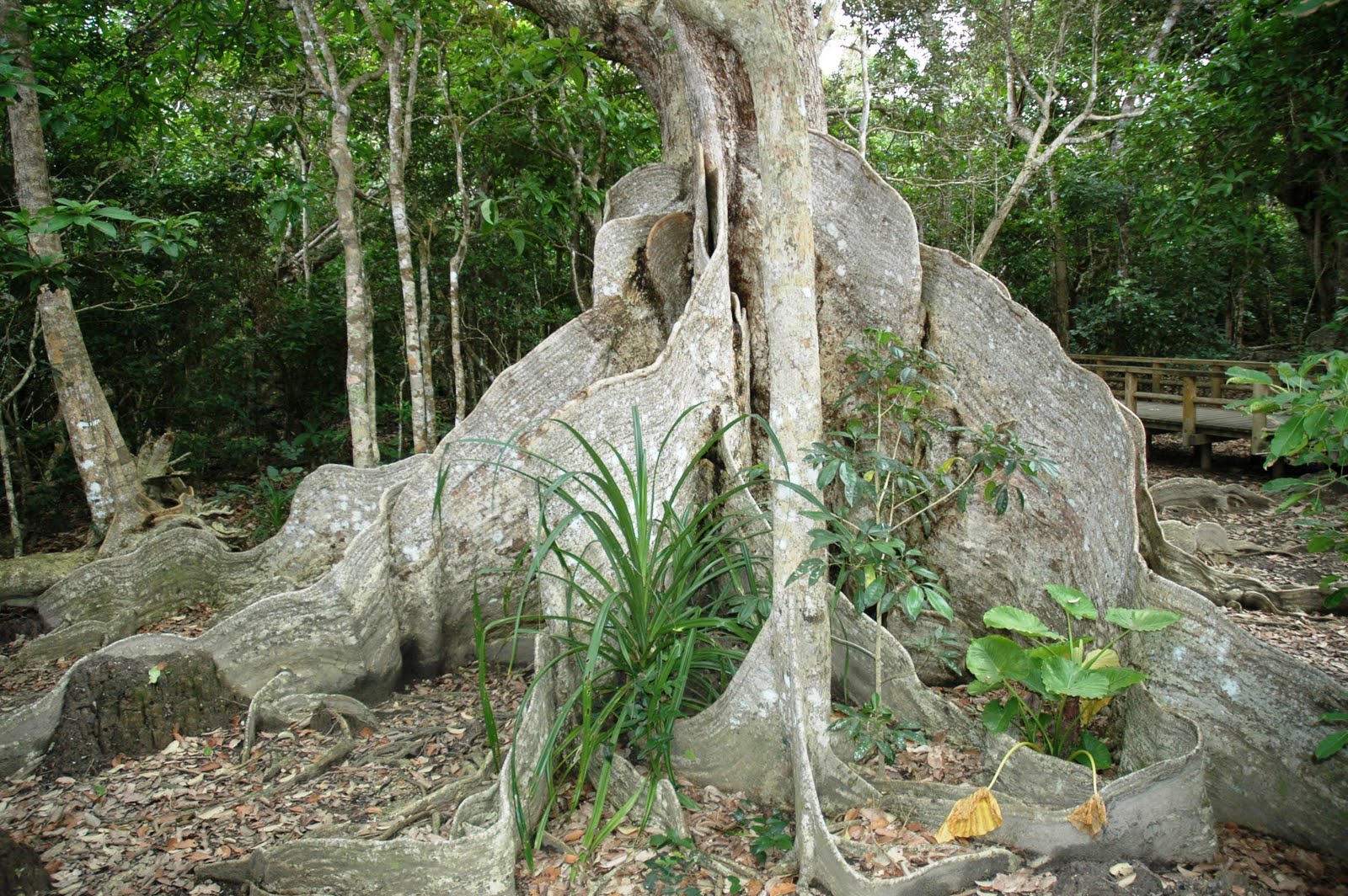
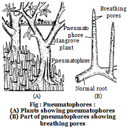
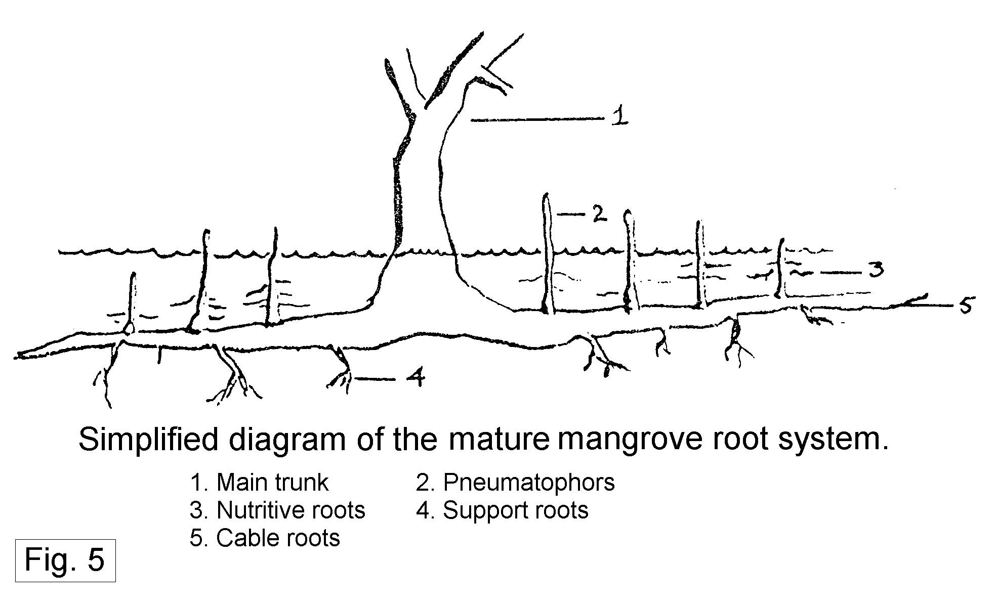
      • Prominent among these adaptations are the presence of stilt roots, buttress, pneumatophores etc.
        • Stilt roots (also called prop roots)- Stilt roots outgrow the trunk of the mangrove, branches or already existing stilt roots. As soon as stilt roots reach the ground the tip of the stilt root develops an underground root system with which it connects the stilt root into the ground and then develops one or more further stilt roots which grow arcuately into the air to again run into the ground to develop an underground root system, this process repeats several times.

          Source

        • Buttress Roots – Buttress roots, developed by many trees concerning mangroves, provide stability to huge trees. The buttress roots can grow up to 10 meters in height. Buttress roots, also called buttresses do not continue their growth underground as they do above, underground buttresses develop a huge amount of small roots that grow in the soil under the buttress root.

          Source

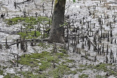
        • Pneumatophores – Because of waterlogged conditions, the roots are deprived of oxygen during high tides. Some mangrove roots extend vertically above the ground. These specialised roots are known as pneumatophores. These have pores which enable the trees to breathe when other roots are submerged under water during high tide.

          Source

          Sunderbans breathing roots

          Source

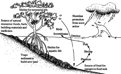
      • Mangrove shrubs, known best for a thriving aquatic life nurtured within their mesh of stilt-roots also serve a vital socio-economic function. They act as “green shields” buffering the coastline against sea erosion, and the potentially devastating impacts of cyclones and tsunami.
      • Mangroves support livelihood, essentially aquaculture, they supply medicinal plants, and fuel wood and construction materials. And in terms of ecological services, they stabilise shorelines, are nurseries for fishbreeding and filter heavy metals.

    Note:

    A study in November 2014 found mangrove patches in Karnataka. The Forest Survey of India missed recording these mangrove patches earlier as they were not large. According to the study, Karnataka has 300 hectares of mangrove forests spread over 3 coastal districts and a vibrant saline water ecosystem generally associated with India’s east coast. At the confluence of 4 rivers – Aghanashini, Gangavali, Sharavati and Venkatpura; and the Arabian Sea, is a long stretch of dense and tall mangrove vegetation locally known as Kandla or Sundar (Sundar is a well-known species of trees in mangrove forests after which the Sunderbans have been named). The study notes that while mangroves have been declining in several parts of the world from timber harvesting and pollution, these forests in Karnataka have in fact grown spatially over the last two decades.

    Grasslands in India:

    Owing to a short monsoon season followed by a long hot dry season, grasslands equivalent to Steppe/Pampas/Savanna are absent in India. The closed deciduous forest grades into thorny forest without an intermediate park like stage, and there is no steppe type of Grassland between the woodland and the desert.

    But locally available types of grassland are:

    1. Hilly/Upland Grassland:
      • Himalayas (generally above 1000m height)
      • Deccan Plateau Hills (Western Ghats in Karnataka where forests have been cleared)
      • Nilgiris have extensive grassy slopes (grass is often found interspersed with small isolated ‘shola’ forests*).
    2. Low Lands: in the plains of Punjab, Haryana, UP, Assam and Bihar.
    3. Riverine Grasses: These are found along the banks of the rivers which provide grazing facilities to cattle especially the bhabar pastures in northern India.

    *‘Sholas’ are the mixed dense forests of tropical evergreen and temperate evergreen rainforest species in the Nilgiri Hills. The patches of shola forests are found mainly in valleys and are usually separated from one another by undulating montane grassland. The shola and grassland together form the shola-grassland complex or mosaic.

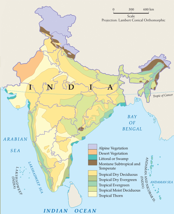
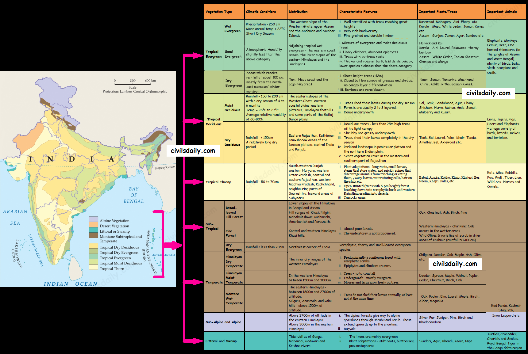
    Now that we are done with the vegetation types of India, expand the following image for a quick revision!
    The Vegetation Types of India
  • Natural Vegetation and Wildlife: Part 2 | Tropical Evergreen, Tropical Deciduous and Tropical Thorny Vegetation

    Moving on, let’s discuss the various natural vegetation types of India in detail:

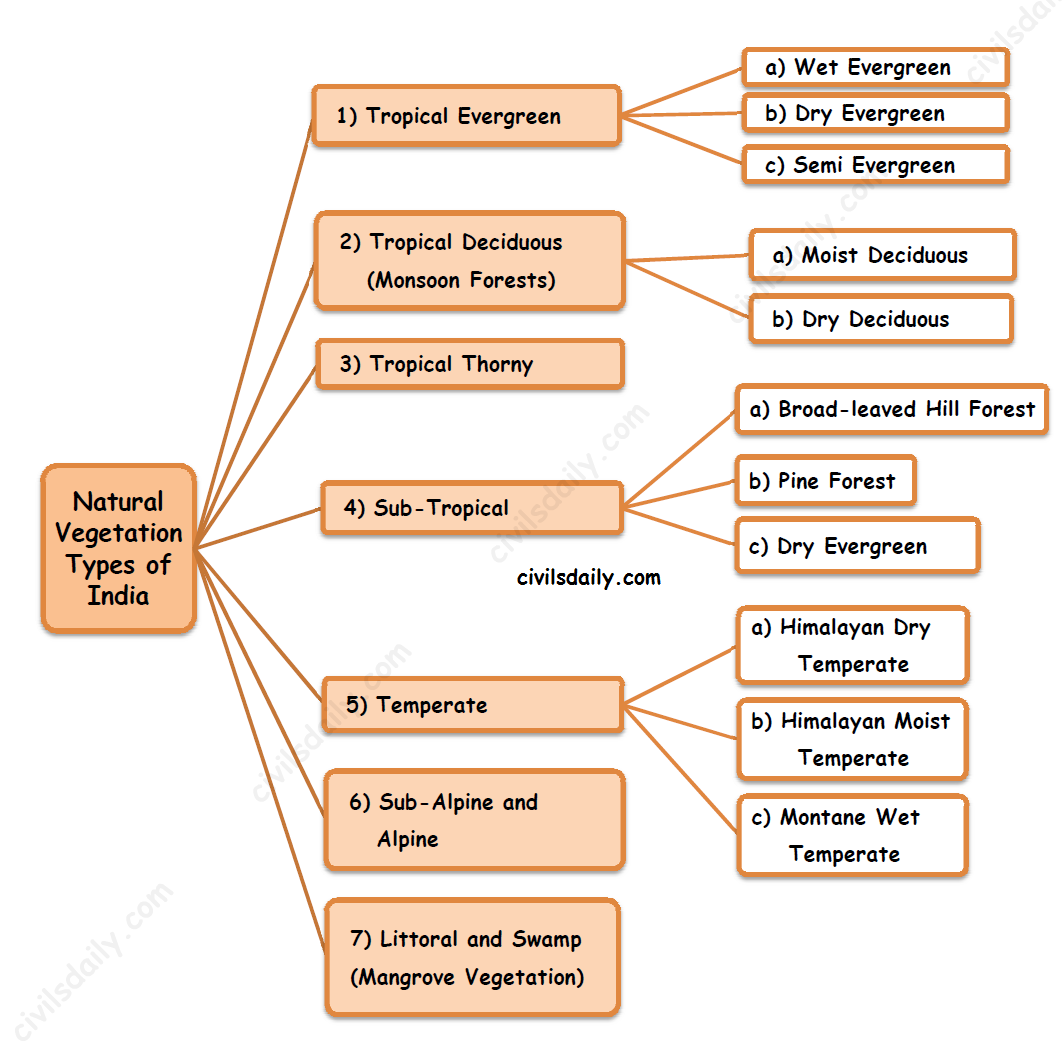
    Natural Vegetation Types of India

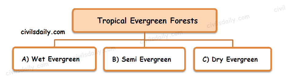
    1. Tropical Evergreen Forests

    ‘Evergreen’ because there is no definite time for trees to shed their leaves, flowering and fruition. As such these forests appear green all the year round.

    The common animals found in these forests are elephants, monkey, lemur and deer. The one-horned rhinoceros are found in the jungles of Assam and West Bengal. Besides these animals, plenty of birds, bats, sloth, scorpions and snails are also found in these jungles.

    A. Tropical Wet Evergreen Vegetation:

    • Distribution: These forests are found on the western slope of the Western Ghats, upper Assam through Cachar and the Andaman and Nicobar Islands.
    • Climatic Conditions: They are found in warm and humid areas with an annual precipitation of over 250 cm and a short dry season. The mean annual temperature here is above 22°C.
    • Characteristic Features:
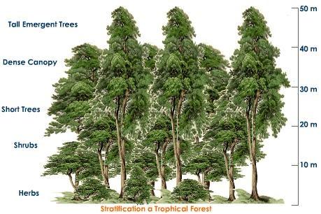
      • Tropical evergreen forests are well stratified, with layers closer to the ground covered with shrubs and creepers, followed by short structured trees, further followed by tall variety of trees.
      • In these forests, trees reach great heights up to 60 m or above.
      • Bounded by semi-evergreen forests on drier margins.
      • Very rich biodiversity.
      • Timber produced in these forests is fine-grained and durable.
    • Important Species found in these forests: Rosewood, Mahogony, Aini, Ebony, etc. Important species in Kerala are Mesa, White cedar, Jamun, Canes etc. Common species found in Assam forests are Gurjan, Jamun, Agar, Bamboo etc.

    B. Tropical Semi-Evergreen Vegetation:

    • Distribution: These forests occur in areas adjoining tropical wet evergreen, and form a transition between evergreen and moist deciduous forests. These forests occur on the western coast, in Assam, on the lower slopes of the eastern Himalayas and in the Andamans in the areas where precipitation and atmospheric humidity is slightly less than that in tropical evergreen vegetation area.
    • Characteristic Features:
      • Such forests have a mixture of evergreen and moist deciduous trees. The undergrowing climbers provide an evergreen character to these forests.
      • The climbers are heavy, bamboos are less prevalent and epiphytes are abundant. [Epiphytes – The plants which depend on other plants for mechanical support (and not for nutrients). e.g. lichens, mosses, orchids etc.]
      • The forest is dominated by a variety of large trees with a tendency to gregariousness (i.e. growing in groups that are close together)
      • Plant Adaptations in these areas:
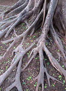
        • Buttresses – Many large trees have huge ridges called buttresses near the base that can rise 30 feet high before blending into the trunk. Buttress roots provide extra stability and increase the surface area of a tree so that it can ‘breathe in’ more carbon dioxide and ‘breathe out’ more oxygen. Typically, they are found in nutrient-poor rainforest soils and do not penetrate to deeper layers.

          Source. A buttress root system provides structural support.

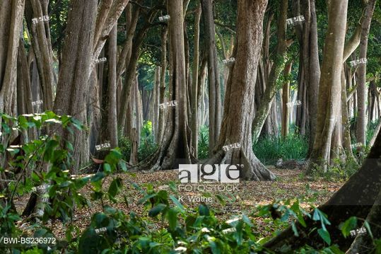
          Big trees with buttress roots in tropical evergreen forest, India, Andaman Islands, Havelock Island. Source.

        • The bark is thicker and rougher, and the canopy is less dense than that in the previous type. Also, the canopies are not continuous and species richness is lower
    • Main species are white cedar, hollock and kail. Important Species in Kerala are Aini, Laurel, Rosewood, thorny bamboo, etc. Important species of northeastern India are White Cedar, Indian Chestnut, Champa and Mango.

    C. Tropical Dry Evergreen Vegetation:

    • Distribution: This type is confined to the Tamil Nadu coast and the areas which receive rainfall of about 100cm mostly from the north-east monsoon/winter monsoon (October-December).
    • The growth of evergreen forests in areas of such low rainfall arouses great botanical interest. This vegetation may be due to the seasonal distribution of rainfall (winter rainfall).
    • Characteristic Features of this vegetation:
      • Short height trees (<12m)
      • A closed but low canopy of grasses and shrubs.
      • No canopy layer differentiation.
      • Bamboos are rare /absent.
    • Important Species found in these forests: Neem, Jamun, Tamarind, Machkund, Khirni, Kokko, Ritha, Gamari Canes.
    • Most of the land under these forests has been cleared for agriculture or casuarinas plantations (Eucalyptus tree plantations)

    2. Tropical Deciduous Vegetation

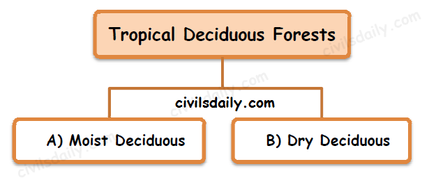
    Also called the monsoon forests, these are the most widespread forests in India. The term ‘Deciduous’ refers to the ability of some plants to lose their leaves annually. They are spread over regions which receive rainfall between 70 and 200 cm.

    In these forests, the common animals found are lion, tiger, pig, deer and elephant. A huge variety of birds, lizards, snakes, and tortoises are also found here. [Currently, India is the only country on Earth confirmed to have both lions and tigers in its wilderness.]

    On the basis of the availability of water, these forests are further divided into:

    A. Tropical Moist Deciduous Vegetation

      • Climatic Conditions: It thrives in areas having of moderate rainfall of 150-200 cm with a dry season of 4 to 6 months, a mean annual temperature of 26°C to 27°C and an average relative humidity of 60-80%. On the wetter margins, it has a transition to the tropical Semi-Evergreen Vegetation, while on the drier margins to the Tropical Dry Deciduous.
      • Distribution: It is found on the eastern slopes of the Western Ghats, eastern coastal plains, eastern plateaus, Himalayan foothills and in some parts of the Satluj-Ganga plains.
      • Characteristic Features:
        1. The trees shed their leaves during the dry season.
        2. These forests are usually 2 to 3 layered.
        3. Dense undergrowth
    • Important Species: The common trees are Sal, Teak, Sandalwood, Ajun, Ebony, Shisham, Hurra, Mahua, Amla, Semul, Mulberry and Kusum.

    B. Tropical Dry Deciduous Vegetation

    • Climatic Conditions: The dry deciduous trees grow in areas where rainfall is less than 150cm and the dry period is relatively long. On the wetter margins, it has a transition to the moist deciduous, while on the drier margins to thorn forests.
    • Distribution: It is found in Eastern Rajasthan, Kathiawar, rain-shadow areas of the Deccan plateau, central India and Punjab.
    • Characteristic Features:
      • These forests consist of trees less than 25m high, with a light canopy consisting of deciduous trees. The undergrowth is shrubby and grassy.
      • As the hot dry season begins (March-May), the trees shed their leaves completely and the forest appears like a vast grassland with naked trees all around.
      • In the higher rainfall regions of the Peninsular plateau and the northern Indian plain, these forests have a parkland landscape i.e. trees are more stunted and widely spaced and are interspersed with patches of grass.
      • In the western and southern part of Rajasthan, vegetation cover is very scanty due to low rainfall and overgrazing.
    • Important Species: Common plants are Teak, Sal, Laurel, Palas, Khair, Tendu, Amaltas, Bel, Axlewood etc.

    3. Tropical Thorny Vegetation

    • Climatic Conditions: In areas with 50-70cm of rainfall
    • Distribution: It is found in south-western Punjab, western Haryana, western Uttar Pradesh, central and eastern Rajasthan, western Madhya Pradesh, Kachchhand, neighbouring parts of Saurashtra, leeward areas of Sahyadris.
    • Characteristic Features:
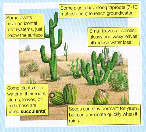
      • Plant life is highly specialized to adapt to the coarse and dry conditions in this area, with long roots, small leaves, stems that store water, and prickly spines that discourage animals from touching or eating them.
      • The natural vegetation consists of open stunted (trees with 6-9m height) forest breaking down into xerophytic bush and western Rajasthan grading into deserts.
      • In these forests, plants remain leafless for the most part of the year and give an expression of scrub vegetation.
      • Plant adaptations:
        • These xerophytic plants combat drought with certain devices of water preservation like partial or complete replacement of leaves by thorns, waxy leaves, water storing cells, hair on the stalk etc.
        • Tussocky grass grows up to a height of 2 m as the undergrowth.
        • Trees are scattered and have long roots penetrating deep into the soil in order to get moisture.
        • The stems are succulent to conserve water.
        • Leaves are mostly thick and small to minimize evaporation.

          Source

    • Important Species: Common species are Babul, Acacia, Kokko, Khair, Khajuri, Ber, Neem, Khejri, Palas, etc.
    • In these forests, the common animals are rats, mice, rabbits, fox, wolf, tiger, lion, wild ass, horses and camels.
  • Natural Vegetation and Wildlife- Part 1 | An Overview of Natural Vegetation Types Found in India

    Before we discuss the natural vegetation types found in India, let’s get acquainted with some basic terms:

    Flora, Vegetation and Forests:

    Flora refers to plants of a particular region or period, listed as a species and considered as a group. Likewise, fauna refers to the animal life, considered collectively, of any given period, environment or region.

    Vegetation, on the other hand, refers to the assemblage of plant species in a given environmental frame or ecological frame. It is broader than the term flora which refers to species composition. Further:

    • Natural vegetation includes that part of the plant life which grows in wild without human aid and adapts to constraints of the natural environment in size, structure and requirements. Thus cultivated crops and fruit orchards form a part of the vegetation but not natural vegetation.
    • That part of natural vegetation which has remained undisturbed by humans is referred to as virgin vegetation. It can be found in India in the inaccessible parts of the Himalayas, the Thar Desert and the Sunderbans. Elsewhere, human occupation has either transformed natural vegetation into cultivated vegetation or degraded the natural vegetation.
      • The virgin vegetation, which is purely Indian is known as endemic or indigenous species but that which has come from outside India is termed as exotic.

    Forest: The term forest implies ‘natural vegetation’ of the area, existing from thousands of years and supporting a variety of biodiversity, forming a complex ecosystem.

    Depending on the physical, geographical, climatic and ecological factors, there are different types of forests like evergreen forest (mainly composed of evergreen tree species i.e. species having leaves all throughout the year) and deciduous forest (mainly composed of deciduous tree species i.e. species which lose their leaves during particular months of the year). Each forest type forms a habitat for a specific community of animals that are adapted to live in it.

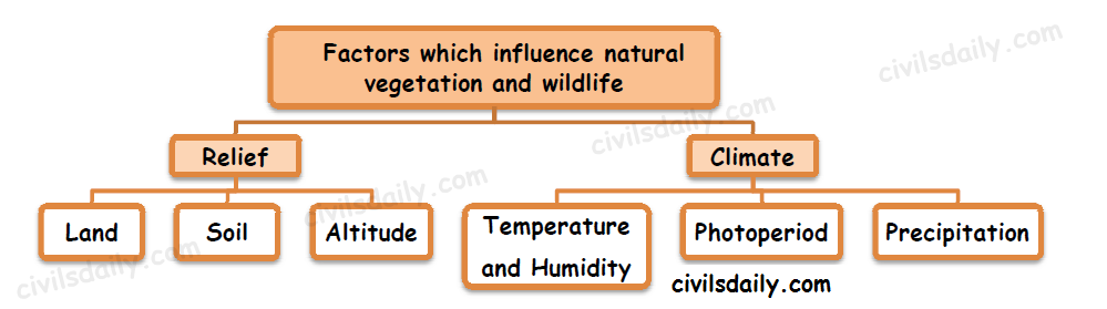
    Various factors which influence the type and distribution of natural vegetation and wildlife:

    • Land

    The nature of land affects the natural vegetation directly and indirectly. E.g. the type of vegetation in the mountainous regions is different than that in the plateau and plain areas. The fertile land is generally devoted to agriculture, while the undulating and rough terrains are areas where grassland and woodlands develop and give shelter to a variety of wildlife.

    • Soil

    Different types of soils provide basis for different types of vegetation. The sandy soils of the desert support cactus and thorny bushes while wet, marshy, deltaic soils support mangroves and deltaic vegetation. The hill slopes with some depth of soil have conical trees.

    • Temperature and Humidity

    Temperature and humidity are the main factors which determine the character and extent of vegetation. E.g. an area with high temperature and high humidity supports evergreen forest, while an area with high temperature and low humidity supports thorny bushes (desert).

    • Precipitation

    Areas of heavy rainfall have more dense vegetation as compared to other areas of less rainfall.

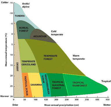
    See the following diagram to understand the combined effect of temperature and annual precipitation on the vegetation type of an area:

    Source
    • Photoperiod (Sunlight)

    Photoperiod, also called the light duration or day length, refers to the length of the light period as compared to the darkness within a day. The variation in photoperiod at different places is due to the differences in latitude, altitude, season and duration of the day. Due to longer duration of sunlight, trees grow faster in summer.

    • Altitude

    Increasing elevation causes a distribution of vegetation similar to that of increasing latitude. In general, ‘altitude mimics latitude’ and there occurs a close parallel between latitudinal and altitudinal zonation of climate and thus natural vegetation too. E.g. Mount Kenya in east Africa and Mount Chimborozo in Equador have their feet on the equator but their peaks are snow covered.

    It was Alexander Von Humboldt who first recognised the relationship between vegetation and altitude.

    Source

    The Forest Types of India:

    Since India is a land of various climatic regions, varied kinds of natural vegetation have developed here. Having said that, rainfall is more important than temperature (except in the Himalayas) in determining the vegetation distribution in India. The seasonal rainfall distribution/the length of the dry season also affect the vegetation distribution in an important way.

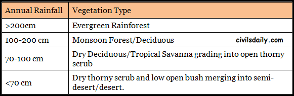
    In general, the following inter-relationship is observed in India:

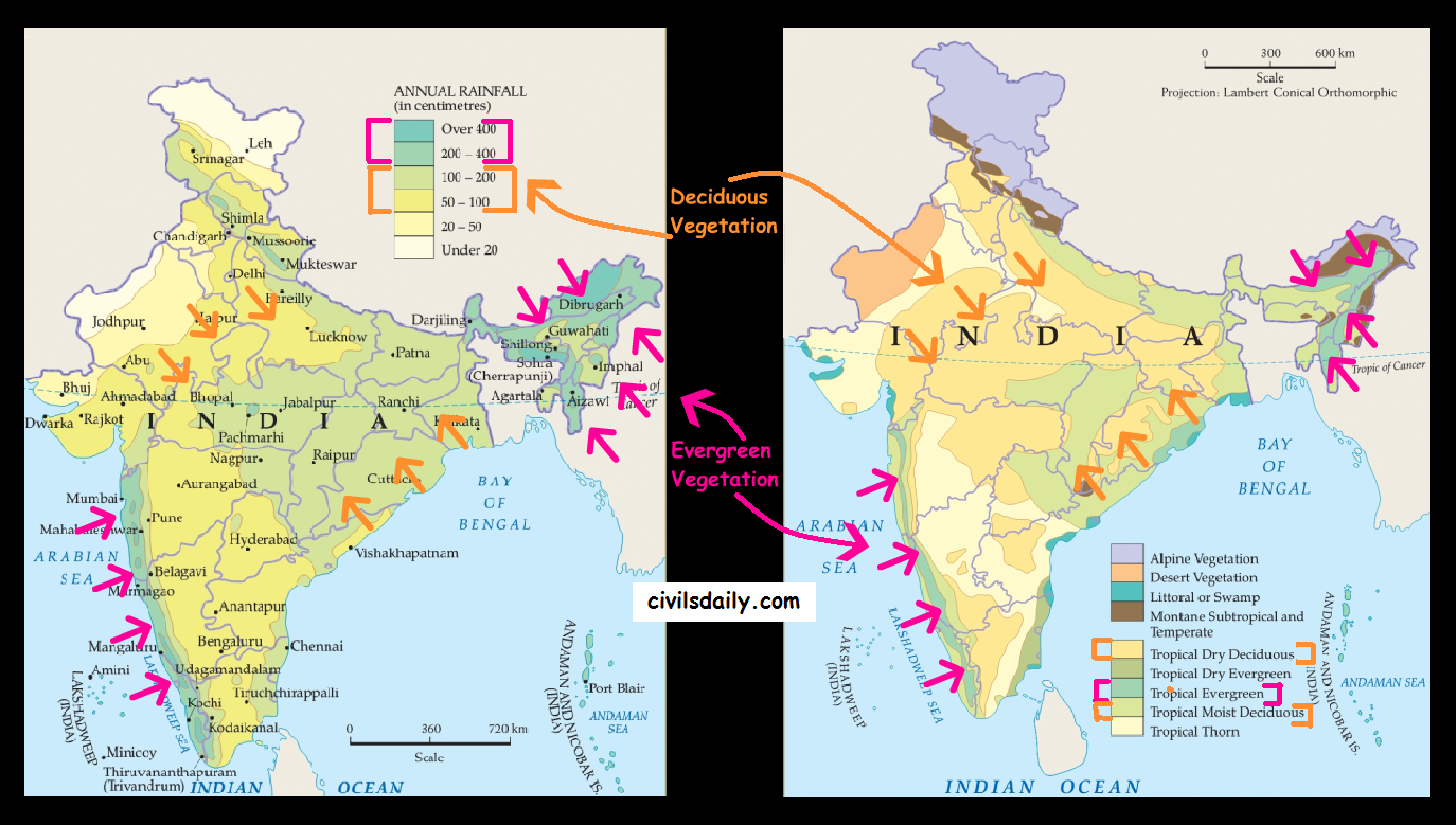
    Observe this broad relationship as highlighted in the following map:

    High rainfall areas (>200cm) —> Evergreen forests grow in the high rainfall areas of the Western Ghats, North –eastern India and the Andaman and Nicobar Islands. These forests grow in areas where the monsoon period lasts for several months. There is no definite time for trees to shed their leaves, flowering and fruition. As such these forests appear green all the year round, hence the name evergreen.

    Moderate Rainfall Areas (70-200cm) —>Deciduous forests are found in regions with a moderate amount of seasonal rainfall that lasts for only a few months. Most of the forests in which Teak trees grow are of this type. The deciduous trees shed their leaves during the winter and hot summer months.

    Low Rainfall areas/ Semi-arid areas (<70cm) —> Thorn forests are found in the semi-arid regions of India. The trees, which are sparsely distributed, are surrounded by open grassy areas.

    Apart from these, mangroves forests grow along the coast, especially in the river deltas. These plants are uniquely adapted to be able to grow in a mix of saline and freshwater (will be taken up in detail in the following sections.)

  • The Southwest Monsoon Season (Jun – Sep) | Part 2

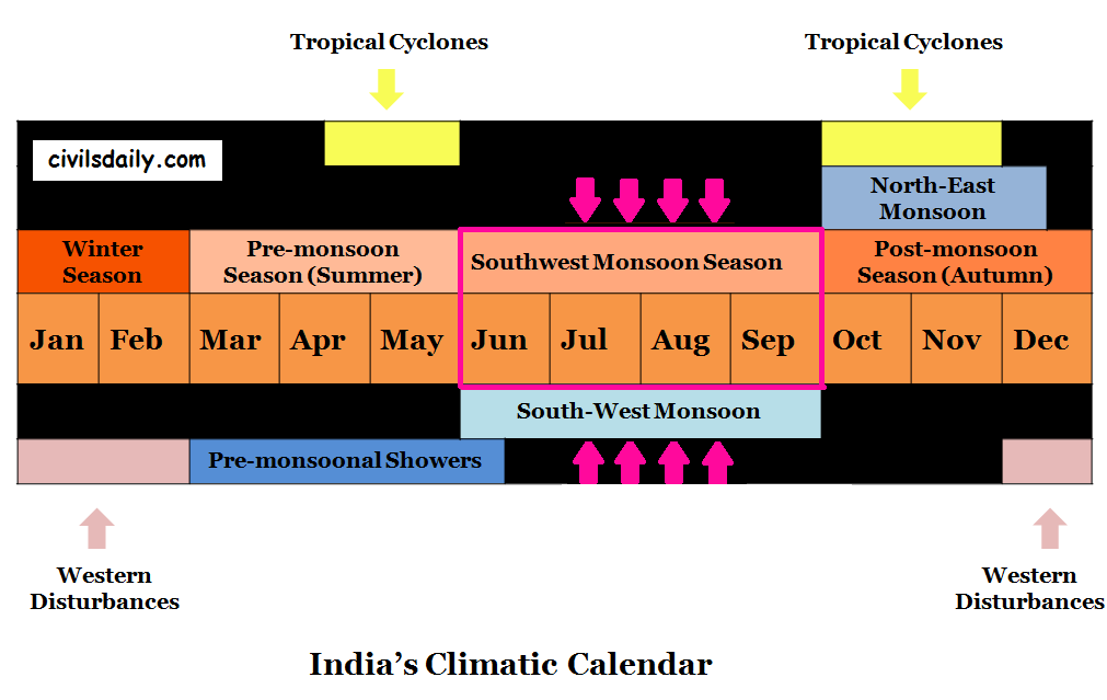
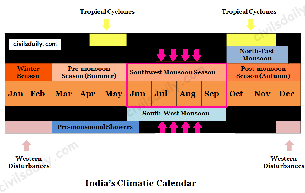
    India’s Climatic Calendar: The Southwest Monsoon Season

    Chief Characteristics of Monsoonal Rainfall:

    • Monsoonal rainfall is largely governed by relief or topography. For example:
      • The windward side of the Western Ghats registers a rainfall of over 250 cm.
      • The heavy rainfall in the north-eastern states can be attributed to their hill ranges and the Eastern Himalayas.
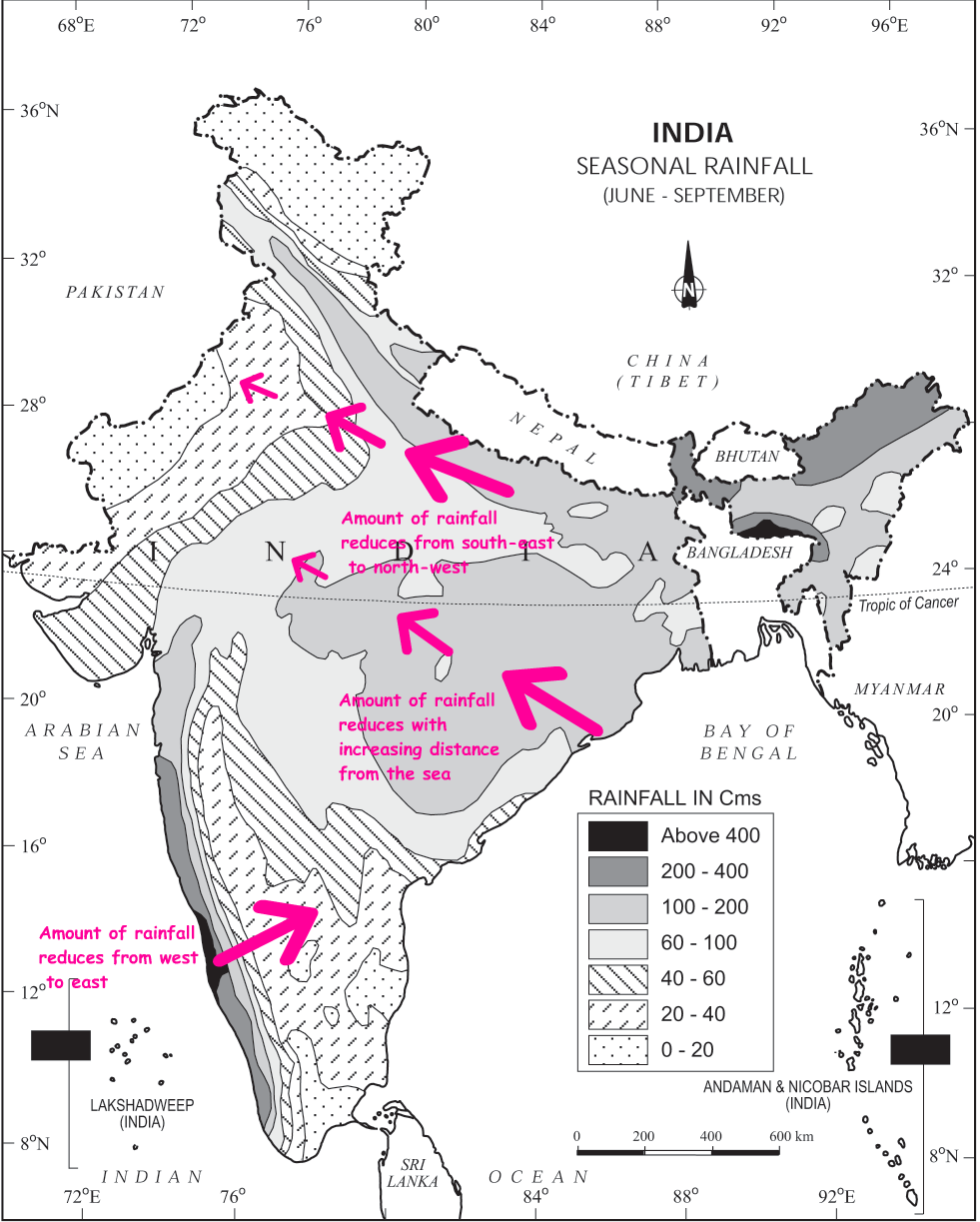
    • The monsoon rainfall has a declining trend with increasing distance from the sea. E.g. consider the amount of rainfall received during the south-west monsoon period at the following places:

    Kolkata (119 cm) –> Patna (105 cm) –> Allahabad (76 cm) –> Delhi (56 cm)

    • The rain comes in spells and displays a declining trend from west to east over the west coast, and from the south-east towards the north-west over the North Indian Plain and the northern part of the Peninsula.
    • Its spatial distribution is also uneven which ranges from 12 cm to more than 250 cm.
    Image Source: NCERT

    What causes monsoons?

    Monsoon is a familiar though a little known climatic phenomenon. Despite the observations spread over centuries, the monsoon continues to puzzle the scientists. Many attempts have been made to discover the exact nature and causation of monsoon, but so far, no single theory has been able to explain the monsoon fully.

    Let’s look at some of the important concepts about the origin of monsoons. We will study these along the following lines:

    1. The Classical Hypothesis
      • Halley(1690’s)
      • Hadley (1730’s)
    2. The role of moisture.
    3. The shifting of ITCZ – Flohn

    Recent theories:

    1. The role of Tibetan plateau
      • As a mechanical barrier
      • As a high-level heat source
    2. The role of jetstreams
      • The Sub-tropical/ tropical westerly jetstream
      • The tropical/ equatorial easterly jetstream

    1. The Classical Hypothesis

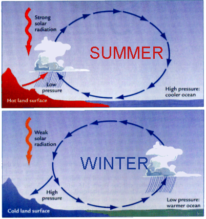
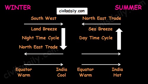
    Halley hypothesized that the primary cause of the annual cycle of Indian monsoon circulation was a differential heating effect between the ocean and land in South Asia.

    • During April and May when the sun shines vertically over the Tropic of Cancer, the large landmass in the north of Indian ocean gets intensely heated. This causes the formation of an intense low pressure in the northwestern part of the subcontinent.
    • The pressure in the Indian Ocean in the south of the landmass is high as water gets heated slowly.
    • This pressure differences causes the flow of winds from the high pressure to low pressure areas

    Thus the first model ever proposed about the mechanism of the Indian monsoon was Haley’s planetary scale sea-breeze – land breeze system in 1690’s.

    Image Source
    Indian Monsoon: Haley’s Planetary Scale Sea Breeze–Land Breeze Model

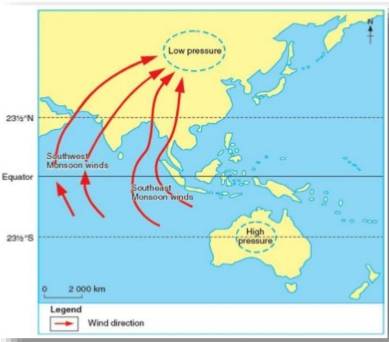
    Hadley later argued that Haley’s model was lacking in the physical ingredient of the effect of rotation of earth about its axis. Hadley reasoned that the monsoon originates in the SE trades of the southern hemisphere and as it flows across the equator towards the heated landmass, the coriolis force causes it to turn to right, thereby forming the summer monsoon or the SW monsoon.

    Image Source

    2. The role of moisture:

    Moisture plays an important role in the atmospheric circulation which was not appreciated by either Halley or Hadley.

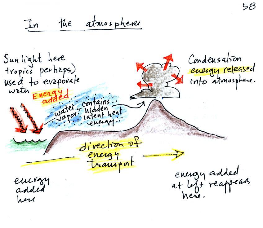
    In this respect, the release of latent heat augments the differential heating produced by the land-sea contrast by providing a mechanism for the solar energy received over the vast stretches of the Indian Ocean to be collected, stored, concentrated and later released over the parched landscape of India by a massive atmospheric motion (See the following image to understand this transfer of solar energy) . As the moisture laden air comes over India, with its upliftment there takes place condensation releasing latent heat – augmenting the low pressure conditions i.e. the cause getting augmented by its effect.

    Image Source

    The shifting of ITCZ – Dr. Flohn

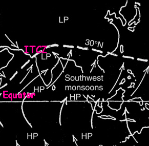
    The existence of Asian monsoon according to Dr. Flohn is not due to the temperature contrast between land and sea but primarily due to the annual migration of thermally induced planetary winds and pressure belts. For Flohn, the winter monsoon is nothing but the tropical easterlies or the northern trade winds. According to Flohn, the SW monsoon is constituted by the equatorial westerlies which have been displaced northward (because of shift of ITCZ by 20° or more).

    Shifting of the ITCZ and the Indian Monsoon – Dr. Flohn

    Recent Theories:

    1. The role of Tibetan Plateau:

    A remarkable aspect of the large scale circulation during the summer monsoon season over south-Asia is the upper tropospheric anti-cyclone situated over the Tibetan Plateau.

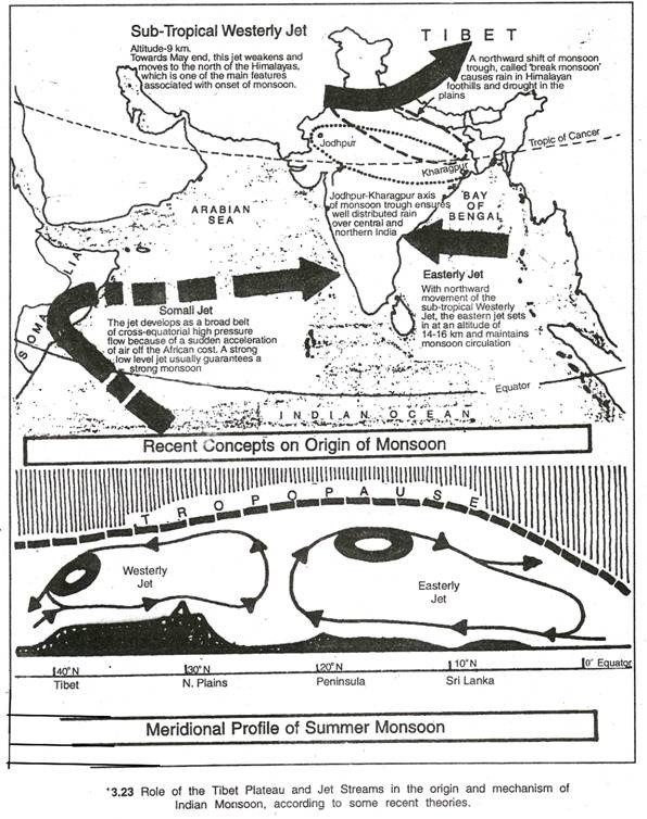
    • The Tibetan Plateau located more than 4500m above mean sea-level with a length of 2000km and width of 600km in the west and 1000km in the east, is considered to be one of the key factors in the development of monsoon circulation in the region.
    • The Tibetan plateau exerts its influence both as a mechanical barrier in the atmospheric flow as well as a high level heat source.
    • An anti-cyclone appears in the upper troposphere over Tibet during the Indian monsoon season primarily due to latent and sensible heating over the plateau.
    • This anti cyclone appears over south-east Asia in the month of May and then moves north-westwards, reaching Tibetan plateau around the height of the summer monsoon season.
    • From about September, the anticyclone migrates south-eastward towards Indonesia and loses definition after October.
    • Variations in the intensity and position of this High and its orientation have been found to be closely related to the monsoon circulation over South Asia.

    The role of Jet streams:

    Jet streams which affect India’s monsoon:

    1. Sub tropical/ Tropical Westerly Jet stream (TWJS) ~27°N

    • (Covered in detail in the discussion on winter season. Need to revise? Click here!)
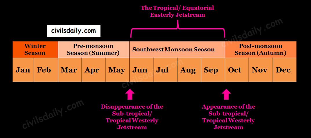
    • According to Dr. Koteshwaram, the disappearance of this jet from the south of the Himalayas paves the way for the burst of South-West Monsoon along the coast of Kerala.

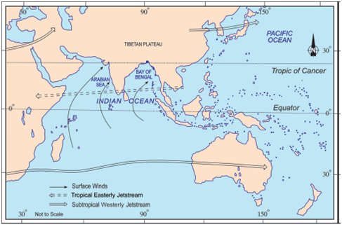
    2. Tropical/ Equatorial Easterly Jet stream (TEJS) ~14°N

    • This jet is a prominent feature of the upper air circulation during the Indian summer monsoon season (June – September). It appears as a band of strong easterlies extending from SE Asia across the Indian Ocean and Africa to the Atlantic, generally at a height of about 14 kms. It is present over south Indian peninsula between 12° and 15°N with a mean position of 14°N. This easterly jet stream is held responsible for the burst of the monsoon in India.
    • The position and speed of this jet have been found to have significant spatial and temporal fluctuations, which in turn correlate with monsoon rainfall distribution over peninsular India.

    The Subtropical Westerly Jetstream and the Tropical Easterly Jetstream

    Factors which influence the South-West monsoon intensity and rainfall distribution:

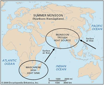
    • Mascarene High and the Somali Jetstream: It is the high pressure area at sea level south of the equator in the Indian Ocean near Mascarene Islands. The position and intensity of this high are considered to be closely linked to the south summer monsoon activity.

    According to scientists, the broad belt of high pressure around the Mascarene Islands generates a cross-equatorial flow known as the Somali Jet which brings heavy rain to India’s west coast. A strong, low level jet usually means a strong monsoon over peninsular India.

    Image Source

    • Variation in the axis of the monsoon trough: The monsoon trough axis experiences considerable day to day variation in its position, which has a vital bearing on the monsoon rainfall distribution in the region. During the break monsoon periods, when there is a temporary lull in monsoon activity, the trough line shifts to the foothills of the Himalayas. Rainfall over the central parts of India decreases considerably and there is an increase in rainfall over northern India along the Himalayan foothills.
    • Teleconnections (ENSO – El–Nino and Southern Oscillation Index):

    A. Southern Oscillation Index (SOI)

      • A curious see-saw pattern of meteorological changes has been observed b/w Indian Ocean & Pacific ocean. Whenever pressure is higher over Indian Ocean, low pressure prevails over Pacific Ocean & vice versa. This see-saw relationship is referred to as the Southern Oscillations.
      • To measure this pressure difference, a SOI has been developed based on the pressure data at certain representative stations (e.g. the SOI between Tahiti island and Darwin is the most widely used)

    SOI (Southern Oscillation Index) = (Atm. Pressure @Tahiti) – (Atm. Pressure @Darwin)

    Tahiti = Pacific Ocean, Darwin = Indian Ocean

    B. El-Nino (Spanish for male child)

      • It is an anomalous warming of the Eastern Tropical Pacific Ocean that occurs at 2 – 10 years intervals and is frequently associated with far reaching climatic and oceanic impacts around the world.

    These two are believed to be inter-connected – the southern oscillation has been identified as the atmospheric counterpart to El-Nino. Both are together referred to as ENSO.

    During the high southern oscillation phase (Normal situation), precipitation tends to be abundant in the Indonesian – Australian region, most of the south Asian region, SE Africa and northern coast of South America. Relatively dry conditions prevail over the equatorial pacific, east central Africa and northern Mexico.

    During the low phase of the southern oscillation (El-Nino), the rainfall anomalies are approximately opposite. The El-Nino is found to be adversely correlated with the SW monsoon rain.

    La-Nina (Spanish for girl child) refers to the reinforced normal situation and is found to be positively correlated with the SW monsoon rain.

    Image Source

  • The Southwest Monsoon Season (Jun – Sep) | Part 1

    India’s Climatic Calendar: the South-West Monsoon Season

    Temperature Conditions during this season:

    As the sun shifts northwards, the temperature rapidly increases especially in the northern India.

    The wind circulation over the subcontinent undergoes a complete reversal at both, the lower as well as the upper levels. Let’s see how:

    Distribution of air pressure and winds on the surface of the earth:

    • As a result of rapid increase in temperature in May over the north-western plains, the low-pressure conditions over there get further intensified.
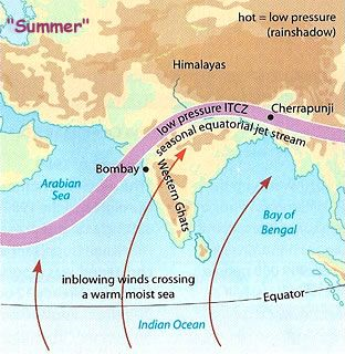
    • Because of the heating of the subcontinent, by the middle of July, the low-pressure belt near the surface [termed as Inter Tropical Convergence Zone (ITCZ)] shifts northwards, roughly parallel to the Himalayas between 20° N and 25° N. The ITCZ in this position is sometimes called the monsoon trough.

    [Revision Note: ITCZ is the low-pressure zone located at the equator where the trade winds converge. It is also referred to as the thermal equator. It is a zone of generally calm, hot, rising air and low pressure.]

    • Roughly, this elongated low-pressure monsoon trough extends over the Thar desert in the north-west to Patna and Chotanagpur plateau in the east-southeast.
    • Meanwhile, the sea surrounding India heats up slowly, creating a zone of relatively high pressure off India’s Southern Coastline.
    • Next, because winds blow from high to low pressure, warm moisture-laden air moves south-westerly direction from the sea over to India in the north and North East and is deflected by the Coriolis force as the Earth spins. It is this moist air current which is popularly known as the south-west monsoon.

    Image Source

    Jet Stream and Upper Air Circulation:

    • By this time, the westerly jet stream withdraws from the Indian region. In fact, meteorologists have found an interrelationship between the northward shift of the equatorial trough (ITCZ) and the withdrawal of the westerly jet stream from over the North Indian Plain. It is generally believed that there is a cause and effect relationship between the two.
    Indian Monsoons: Jetstreams and the Shifting of ITCZ
    • An easterly jet stream flows over the southern part of the Peninsula in June and has a maximum speed of 90 km per hour. In August, it is confined to 15°N latitude, and in September up to 22° N latitudes. The easterlies normally do not extend to the north of 30° N latitude in the upper atmosphere.
    Image Source: NCERT

    Easterly Jet Stream and Tropical Cyclones: [The tropical cyclones were discussed in detail in the discussion on summer season. Remember? Revise here before moving forward!]

    • The easterly jet stream steers the tropical depressions into India.
    • These depressions play a significant role in the distribution of monsoon rainfall over the Indian subcontinent. The tracks of these depressions are the areas of highest rainfall in India.
    • The frequency at which these depressions visit India, their direction and intensity, all go a long way in determining the rainfall pattern during the south-west monsoon period.

    The onset and progress of South-West Monsoon in India:

    1. Entry of Monsoon into India:

    • The rain in the south-west monsoon season begins rather abruptly. This sudden onset of the moisture-laden winds associated with violent thunder and lightning is often termed as the “break” or “burst” of the monsoons.
    • The mean date for the burst of monsoon along the coast of Kerala is 1 first June with a coefficient of variation of a week. It reaches the interior parts of the country by the first week of July. By mid-July, south-west monsoon engulfs the entire subcontinent.

    Image Source

    • Impact of this rainfall: One result of the first rain is that it brings down the temperature substantially. The day temperature registers a decline of 5°C to 8°C between mid-June and mid-July.

    2. The progress of monsoons: As these winds approach the land, their south-westerly direction is modified by:

    • The relief, and
    • The thermal low pressure over the north-west India.

    The monsoon approaches the landmass in two branches:

    • The Arabian Sea branch
    • The Bay of Bengal branch.
    Indian Monsoons: the Arabian Sea Branch and the Bay of Bengal Branch

    The Arabian Sea branch:

    The monsoon winds originating over the Arabian Sea further split into three branches:

    1. One branch is obstructed by the Western Ghats.
      • As these winds climb the slopes of the Western Ghats, they become cooler, their moisture retention capacity reduces and as a result, the windward side of the Sahyadris and Western Coastal Plain receive very heavy rainfall ranging between 250 cm and 400 cm.
      • Much of the rainfall along the Western Ghats is thus orographic, as the moist air is obstructed and forced to rise along the Ghats.
      • After crossing the Western Ghats, these winds descend and get heated up. This reduces humidity in the winds. As a result, these winds cause little rainfall east of the Western Ghats. This region of low rainfall is known as the rain-shadow area.

    Image Source

    1. Another branch of the Arabian Sea monsoon strikes the coast north of Mumbai. Moving along the Narmada and Tapi river valleys, these winds cause rainfall in extensive areas of central India. The Chotanagpur plateau gets 15 cm rainfall from this part of the branch. Thereafter, they enter the Ganga plains and mingle with the Bay of Bengal branch.
    2. The third branch of this monsoon wind strikes the Saurashtra Peninsula and the Kachchh. It then passes over west Rajasthan and along the Aravallis, causing only a scanty rainfall. In Punjab and Haryana, it too joins the Bay of Bengal branch. These two branches, reinforced by each other, cause rains in the western Himalayas.

    Note: Though this branch passes through Rajasthan, it does not cause rainfall there. This is because:

    • The direction of Aravallis is parallel to these monsoon winds.
    • The dry and hot winds from the Sindh region of Pakistan lessen the relative humidity of these monsoon winds and do not allow them to get saturated.

    The Bay of Bengal branch:

    • The Bay of Bengal branch strikes the coast of Myanmar and parts of south-east Bangladesh. But the Arakan Hills along the coast of Myanmar deflect a big portion of this branch towards the Indian subcontinent.
    • The monsoon, therefore, enters West Bengal and Bangladesh from the south and south-east instead of from the south-westerly direction.
    • From here, this branch splits into two under the influence of the Himalayas and the thermal low in north-west India.
      • One branch moves westward along the Ganga plains reaching as far as the Punjab plains.
      • The other branch moves up the Brahmaputra valley in the north and the northeast, causing widespread rains.
        • Its sub-branch strikes the Garo and Khasi hills of Meghalaya. The hills of Garo, Khasi and Jaintia are expanded in a funnel shape with an opening towards the sea. So the moist winds coming from the Bay of Bengal undergo a sudden rise here and cause excessive rainfall. Mawsynram, located on the crest of Khasi hills, receives the highest average annual rainfall in the world (1141cm).
        • There is relatively less rainfall on the leeward slope of the Meghalaya Plateau e.g. 143 cm in Shillong and 161 cm in Guwahati which is very less in comparison to that in Mawsynram.
        • The Brahmaputra valley to the north also experiences a rain-shadow effect; the problem is mitigated, however, by the adjacent Himalayas, which cause the winds to rise again, thereby establishing a parallel belt of heavy precipitation.

    Note:

    • The Arabian Sea branch is stronger than the Bay of Bengal branch. 65% of the humidity brought by the monsoon comes from the Arabian Sea whereas the monsoon coming from the Bay of Bengal contributes only 35% to the humidity.
    • In the Gangetic Plains, the two branches merge into one. By the time they reach the Punjab their moisture is largely spent. The gradual reduction in the amount of rainfall toward the west is evidenced by the decline from 162 cm at Kolkata to 66 cm at Delhi and to desert conditions still farther west.
    • Over the north-eastern portion of peninsular India, the two branches also intermittently collide, creating weak weather fronts with sufficient rainfall to produce patches of fairly high precipitation (more than 152 cm) in the Chotanagpur plateau.

    Here it is important to know why the Tamil Nadu coast remains dry during this season.

    It is because:

    • The Tamil Nadu coast is situated parallel to the Bay of Bengal branch of south-west monsoon.
    • It lies in the rain-shadow area of the Arabian Sea branch of the south-west monsoon.

    3. Break in the Monsoon

    During the south-west monsoon period after having rains for a few days, if rain fails to occur for one or more weeks, it is known as ‘break’ in the monsoon. These dry spells are quite common during the rainy season.

    Reasons:

    • These breaks in rainfall are related to the cyclonic depressions mainly formed at the head of the Bay of Bengal, and their crossing into the mainland. Besides the frequency and intensity of these depressions, the passage followed by them determines the spatial distribution of rainfall.
    • In northern India rains are likely to fail if the rain-bearing storms are not very frequent along the monsoon trough or the ITCZ over this region.
    • Over the west coast, the dry spells are associated with days when winds blow parallel to the coast.

    4. The Withdrawal of the SW monsoon:

    The withdrawal of the SW monsoon and the onset of the NE monsoon in the end of September are a gradual phenomenon. They take place almost at the same time and tend to merge. This explains the popularity of the phrase “Retreating Monsoon”. This will be taken up in detail in the discussion on Autumn Season.