Mains Ready By December. Smash Mains & Smash PYQ Admissions Open

Category: Ranker Webinars

  • The Northern and Northeastern Mountains | Part 1

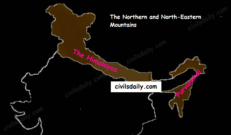
    Let’s begin with the first physiographic division. It consists of:

    • The Himalayas, and
    • The Northeastern hills (Purvanchal).
    The Physiographic Divisions of India | The Northern and Northeastern Mountains

    A) The Himalayas:

    The name “Himalaya” means “the abode or house of snow” in Sanskrit (i.e. hima “snow”, and ālaya “abode or house”). The Himalayas are the highest and longest of all young fold mountains of the world. The Pamir, known as the roof of the world, connects the Himalayas with the high ranges of Central Asia.

    Let’s begin by understanding how the Himalayas came into being:

    Origin and development:

    According to the theory of Continental Drift, the world was made up of a single continent through most of the geologic time. That continent eventually separated and drifted apart; forming the seven continents we have today.
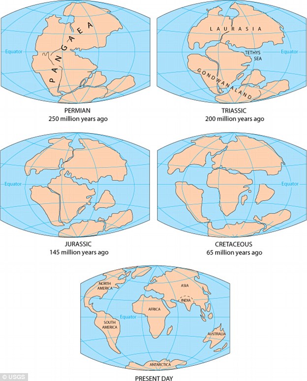
    continental-drift

    Source

    • About 200 million years ago: Pangaea broke apart leading to the formation of two landmasses – “Laurasia in North” and “Gondwanaland in South”. Both the landmasses were separated by a shallow sea called “Tethys Sea”. The size of Tethys sea kept on decreasing due to movement of landmasses towards each other
    • About 40 to 50 million years ago: The two large landmasses, India and Eurasia, driven by plate movement, collided. As a result, the sediments accumulated in Tethys Sea (brought by rivers) were compressed, squeezed and series of folds were formed, one behind the other, giving birth to folded mountains of the Himalayas.
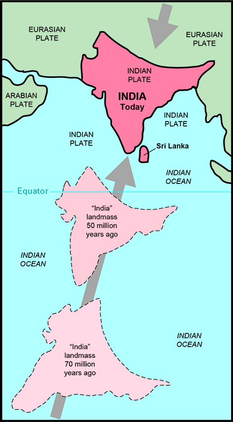
    India moving copy-2

    Source

    Recent studies show that India is still moving northwards at the rate of 5cm/year and crashing into the rest of Asia, thereby constantly increasing the height of Himalayas.

    Evidence to prove that the Himalayas are still rising:

    • Fossil formation found in Shivalik hills:

    Similar fossils have also been found in the Tibet Plateau. This indicates that in the past, Tibetan plateau and Shivalik hills shared a common location, similar level and thus similar vegetation, life etc.; then Tibetan plateau got uplifted.

    • Desiccation of lakes of Tibet:

    In the Tibet plateau, we find deposits which are generally found in lakes. This indicates that lakes once existed in Tibet but because of upliftment the water got discharged and deposits remained.

    • Frequent Earthquakes
    • Youthful nature of rivers (High erosion, v-shaped valleys etc.)

    The North-South Division of the Himalayas

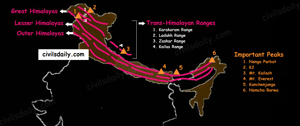
    The Himalayas consist of a series of parallel mountain ranges:

    1. The Greater Himalayan range, which includes:
      • The Great Himalayas(Himadri), and
      • The Trans-Himalayan range
    2. The Lesser Himalayas (or Himachal), and
    3. The Outer Himalayas (or Shiwalik).

    The Himalayan Ranges and Important Peaks

    • Formation of these ranges: The Himadri and Himachal ranges of the Himalayas have been formed much before the formation of Siwalik range. The rivers rising in the Himadri and Himachal ranges brought gravel, sand and mud along with them, which was deposited in the rapidly shrinking Tethys Sea. In course of time, the earth movements caused folding of these relatively fresh deposits of sediments, giving rise to the least consolidated Shiwalik range.
    • Characteristic Features:
      • Notice in the map shown above that the Himalayas form an arcuate curve which is convex to the south. This curved shape of the Himalayas is attributed to the maximum push offered at the two ends on the Indian peninsula during its northward drift. In the north-west, it was done by Aravalis and in the Northeast by the Assam ranges.
      • Syntaxis/ Syntaxial bends: The gently arching ranges of the Himalayan mountains on their Western and Eastern extremities are sharply bent southward in deep Knee-bend flexures that are called syntaxial bends. On both the ends, the great mountains appear to bend around a pivotal point. The western point is situated south of the Pamir where the Karakoram meets the Hindu Kush. A similar sharp, almost hairpin bend occurs on the eastern limit of Arunachal Pradesh where the strike of the mountain changes sharply from the Easterly to Southerly trend. Besides these two major bends, there are a number of minor syntaxial bends in other parts of Himalayas.
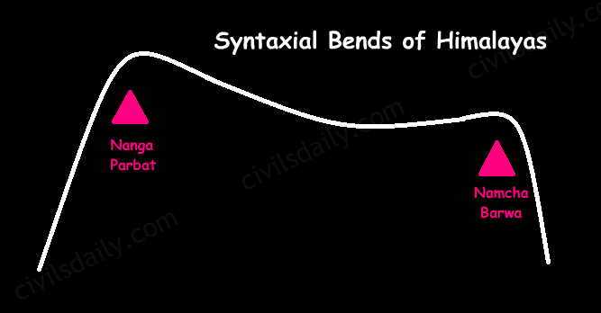
        Syntaxial Bends of Himalayas

      • The Himalayas are wider in the west than in the east. The width varies from 400 km in Kashmir to 150 km in Arunachal Pradesh.The main reason behind this difference is that the compressive force was more in the east than in the west. That is why high mountain peaks like Mount Everest and Kanchenjunga are present in the Eastern Himalayas.
      • The ranges are separated by deep valleys creating a highly dissected topography.
      • The southern slopes of the Himalayas facing India are steeper and those facing the Tibetan side are generally gentler.

    Let’s take up these Himalayan mountain ranges one by one:
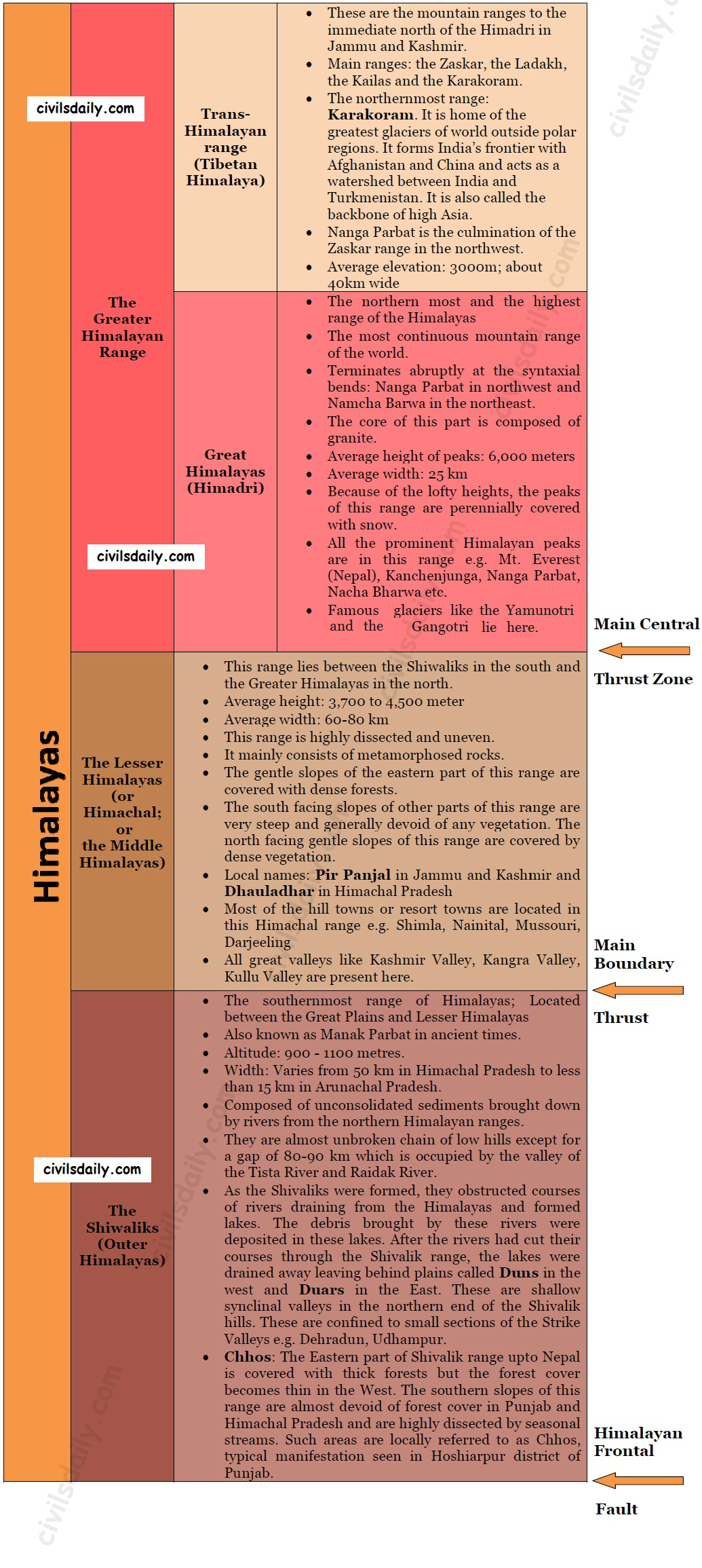
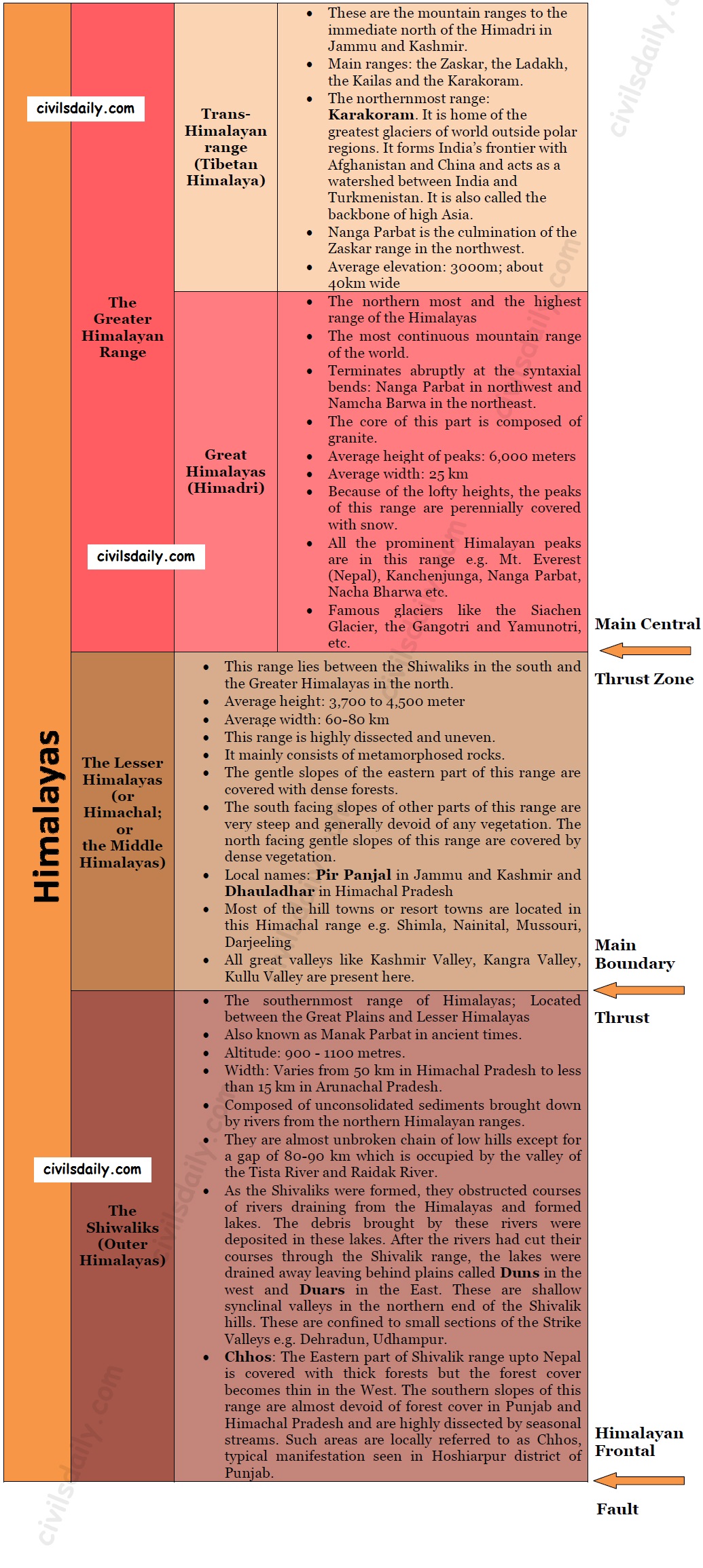
    The Himalayan Ranges | the Greater Himalayan Range, the Lesser Himalayas, the Shivaliks
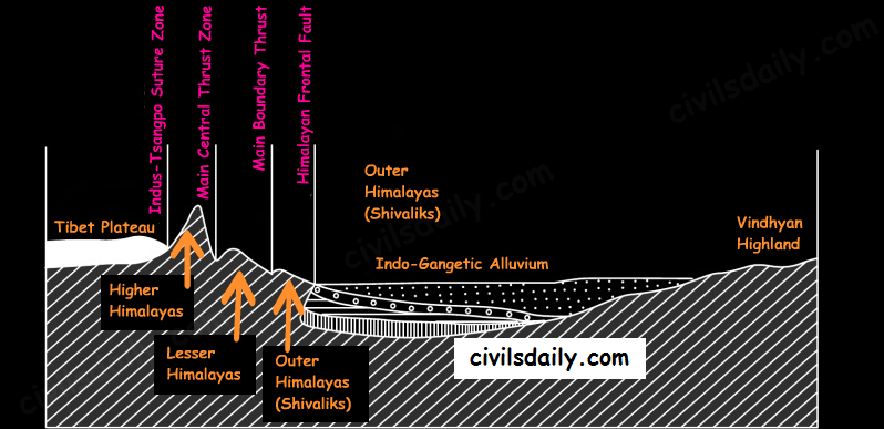
    • Indus-Tsangpo Suture Zone: It represents a belt of tectonic compression caused by the underthrusting of the Indian shield/ plate against the Tibetan mass. It marks the boundary between Indian and Eurasian plates. The suture zone stretches from the North Western Himalayan syntaxis bordering the Nanga Parbat to the East as far as the Namche Barwa Mountain. Tha Karakoram range and the Ladakh plateau lie to the north of ITSZ and originally formed a part of the European plate.
    • Main Central Thrust Zone: This separates the Higher Himalayas in the north from lesser Himalayas in the south. It has played an important role in the tectonic history of these mountains.
    • Main Boundary Thrust: It is a reverse fault of great dimensions which extends all the way from Assam to Punjab and serves to separate the outer Himalayas from the lesser Himalayas.
    • Himalayan Frontal Fault: It is a series of reverse faults that demarcates the boundary of the Shivalik from of the Himalayan province from the alluvial expanse of the Indo-Gangetic plains.
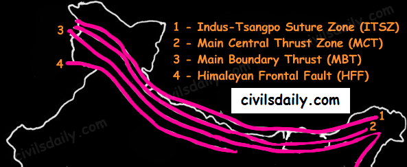
    Major Faults of the Himalayas – ITSZ, MCT, MBT, HFF
    The Himalayan Complex: A Cross-sectional View
  • The Geological Structure of India


    The geological structure of a country helps in understanding the types and character of rocks and slopes, the physical and chemical properties of soils, the availability of minerals, and the surface and underground water resources. But before we can study the geological structure of India, it is important that we understand what a geological time scale means:

    The Geological Timescale

    When did the dinosaurs get extinct? When did the birds first appear on earth? What about the beginning of life itself?

    To answer these questions, geologists use a special timeline called the Geological Time Scale. It is a record of Earth’s Geologic history based on radiometric dating and the record of ancient life preserved in layers of rocks.

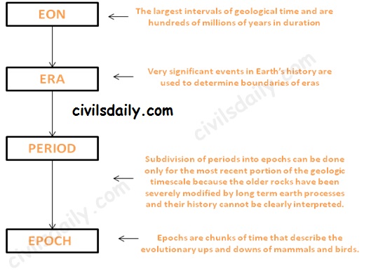
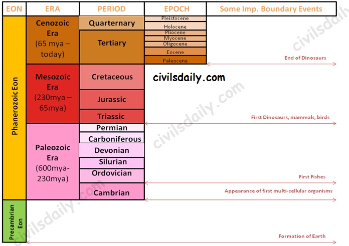
    The geological timescale is broken up into larger and smaller subdivisions which help us understand how the various historical events fit together. These time intervals are not equal in length like the hours in a day. Instead, the time intervals are variable in length because geologic time is divided using significant events in the history of the Earth. The various intervals are:

    Subdivisions of the Geological timescale

    Let’s watch a video to understand this division better:

    The geological timescale thus looks like:


    The Geological Timescale

    Note: Due to lack of sufficient information about the Precambrian Eon, there is no subdivision into eras etc. At the same time, it is important to note that the Precambrian time constitutes about 86.7% of Earth’s history.

    The Indian Geological History:

    Major events in the geological history of India:

    • Peninsular India was a part of the old landmass since the formation of the Earth’s Crust
    • The upheaval of Himalayas in the tertiary period.
    • Aggradational formation of the Indo-Gangetic plain during the Pleistocene period. It continues till today through sedimentation in the floodplains of the rivers and the lower part of the Gangetic plain.

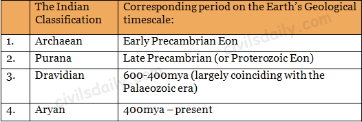
    Based on this complex and varied geological history, the Geological Survey of India has classified rock systems of the country into 4 major divisions:


    Classification of the Indian Rock Systems by the Geological Survey of India

    Let us study the basic features of each of these:


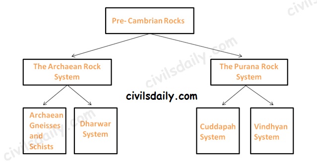
    The Pre-Cambrian Rocks – The Archaean and the Purana Rock System
    1. The Archaean rock system (Early Pre-Cambrian)

    The Archaean group of rocks consists of two systems-(a) Achaean granites and gneisses, and (b) Dharwarian sedimentary:

    • Archaean Gneisses and Schists (pre 2500 million years)
      • The Archean System contains the first formed rocks of the earth.
      • The rocks are primarily gneisses and granites, having no marks of fossils.
      • They often underlie the strata formed subsequently and the system is generally known as the basement complex or fundamental gneisses.
      • The Archaean rocks cover two-thirds of the peninsular India. They also occur in roots of the mountain peaks all along the Greater Himalayas, trans-Himalayan ranges of Zaskar, Ladakh and Karakoram.
    • Dharwar System (2500-1800 million years ago)
      • The weathering of the Archaean rocks yielded the earliest sediments and formed the oldest sedimentary strata, the Dharwar system.
      • These are found today in metamorphic forms and do not contain fossils.
      • These rocks occur in scattered patches in parts of Karnataka, Tamil Nadu, central and eastern parts of Chotanagpur plateau, Meghalaya plateau, Aravalis, Himalayan region etc as shown on the map.

    The Archaean rocks are economically the most important rocks because they possess valuable minerals like high-grade iron ore, manganese, copper, lead, gold, quartzite, slates, mica, etc.

    1. The Purana Rock System (Late Pre-cambrian):

    The Archaean gneiss and the Dharwar rocks underwent further erosion leading to the formation of the Purana Rock system.

    The Purana rock system is further subdivided into (i) the Cuddapah and (ii) the Vindhyan

    • The Cuddapah
      • These rocks are generally without fossils
      • These formations, named after the Cuddapah district in Andhra Pradesh are sedimentary metamorphic formations.
      • These are found in Andhra Pradesh, southern Chhattisgarh, Odisha and along the main axis of Aravallis.
      • The metallic content in ores of Cuddapah rocks is low and at places uneconomical for extraction.
    • The Vindhyan
      • This system derives its name from the Vindhyan mountains
      • Consists of enormous sedimentary deposits. In some tracts, Vindhyan rocks are buried under the Deccan lava.
      • It stretches from Sasaram in Bihar to Chittorgarh in Rajasthan with the exception of the central tract of Bundelkhand gneiss.
      • The well-known diamond mines of Panna and Golconda lie in the Vindhayan region.
      • This rock system is well known for red sandstone, sandstone, durable stones, ornamental stones, raw materials for lime, glass, cement and chemical industries.

    2. The Dravidian Rock system (Cambrian to middle carboniferous)

    • These formations do not occur in the peninsular plateau as it was above the sea level at that time but are found in continuous sequence in the Himalayas.
    • They contain abundant fossils in them
    • Coal formation started in the Carboniferous age. Carboniferous in geology means coal-bearing. [Most of the coal found in India is not of the Carboniferous period; High-quality coal of Great Lakes Region-USA, U.K and Ruhr region is Carboniferous coal].

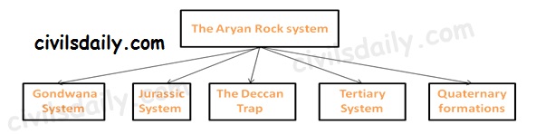
    3. The Aryan Rock system (Upper Carboniferous to recent)


    The Aryan Rock System

    • The Gondwana System:
      • The peninsula during the Upper Carboniferous period experienced crustal movements, which led to the formation of basin-shaped depressions. These depressions had countless terrestrial plants and animals, which were buried to from coal deposits in India known as the Gondwana Rocks.
      • These rocks have also marks of climatic changes from arctic cold to tropical and desert conditions.
      • These Rocks are found mainly in the Damodar, the Mahanadi and the Godavari valleys of the peninsula.
      • Gondwana rocks contain nearly 98 percent of India’s coal reserves. Gondwana coal is much younger than the Carboniferous coal and hence its carbon content is low.
    • Jurassic System:
      • The marine transgression in the latter part of the Jurassic gave rise to thick series of shallow water deposits in Rajasthan and in Kuchchh.
      • Coral limestone, sandstone, conglomerates and shales occur in Kuchchh.
      • Another transgression on the east coast of the Peninsula is found between Guntur and Rajahmundry.
    • The Deccan Trap:
      • Towards the end of the Mesozoic era, intensive volcanic activity took place, which flooded with lava vast areas of Maharashtra and other parts of the Deccan known as the Deccan traps.
      • The volcanic rocks contain some thin fossiliferous sedimentary layers found between the lava flows. This indicates that the lava flows was not continuous. The volcanic activity led to two great events
        1. Breakup of the Gondwanaland masses
        2. Uplift of the Himalayas out of the Tethys Sea.
      • Present Deccan Trap covers about 5 lakh sq km mainly in parts of Kuchchh, Saurashtra, Maharashtra, the Malwa plateau and northern Karnataka.
      • The weathering of these rocks for a long time has given birth to black cotton soil known as ‘regur’.
    • Tertiary System
      • Eocene to Pliocene about 60 to 7 million years ago.
      • The tertiary is the most significant period in India’s geological history because the Himalayas were born and India’s present form came into being in this period.
    • The Pleistocene and recent formations (The quaternary period)
      • Quaternary is the name proposed for very recent deposits, which contains fossils of species with living representatives
      • These include Satluj-Ganga-Brahmaputra plains and Karewa formations of the Kashmir valley.

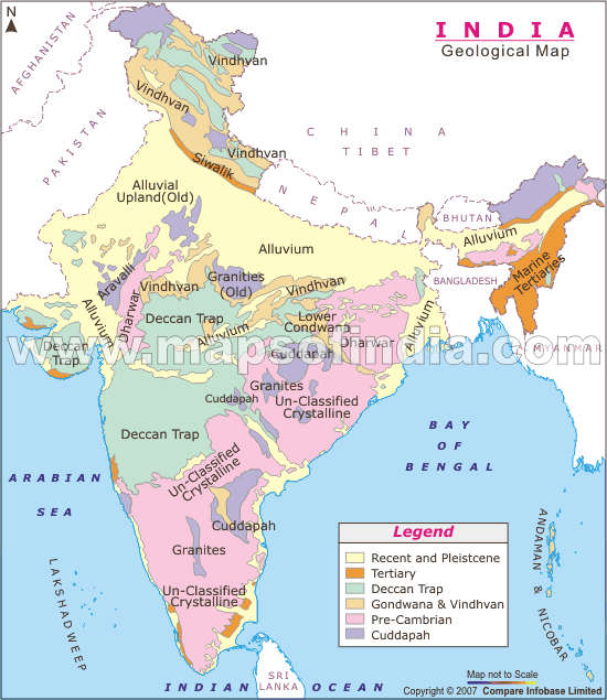
    geological-map-india

    Geological Divisions of India:

    Geologic divisions are marked by geologists as regions of similar rocks, structures and geologic history [Recall the brief geological history of India discussed above]. Geologically, India is divided into 3 major regions (also called the Triple Tectonic division):

    1. The Peninsular Plateau region – It also includes the Shillong Plateau and the Kutchch Kathiawar region (Outliers)
    2. The Extra-peninsular region – the mountainous region of Himalayas.
    • The Himalayas are young, weak and flexible in their geological structure, unlike the rigid and stable Peninsular Block.
    • Consequently, they are still subjected to the interplay of exogenic and endogenic forces, resulting in the development of faults, folds and thrust plains.
    • These mountains are tectonic in origin, dissected by fast-flowing rivers which are in their youthful stage.
    • Various landforms like gorges, V-shaped valleys, rapids, waterfalls, etc. are indicative of this stage.
    1. The Indo-Gangetic Plain between the above two.

    In addition to these, there are 2 minor divisions:

    • The Coastal Plains (Eastern and western)
    • The Islands (Lakshadweep and Andaman and Nicobar)

    Physiographic divisions of India

    Physiography deals with the study of surface features. This includes the landforms (mountains and valleys, their shape and steepness), the way rivers flow across the land, and the way in which the land erodes. Geographers recognize physiographic divisions based on the shape of the land.

    There is a close relationship between India’s physiographic and geologic divisions as geology affects the way the land erodes.

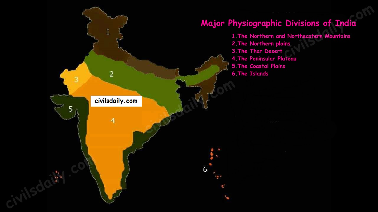
    The Indian landmass can be divided into the following broad physiographic units:

    • The Northern and Northeastern Mountains
    • The Northern plains
    • The Thar Desert
    • The Peninsular Plateau
    • The Coastal Plains
    • The Islands


    The Major Physiographic Divisions of India

    In the next articles, we will study each of these divisions in detail. [For the next article on the Himalayan mountains, click here]

    But before we proceed to the next article, let’s look at the following question from a past UPSC examination:

    Prelims:

    1997:

    Question: Match List I with List II and select the correct answer using the codes given below the lists:

    List I List II

    A) Deccan Traps 1) Late cenozoic

    B) Western Ghats 2) Pre-cambrian

    C) Aravalli 3) Cretaceous Eocene

    D) Narmada-Tapi alluvial deposits 4) Cambrian

    5) Pleistocene

    a) A-3 B-5 C-1 D-4

    b) A-3 B-1 C-2 D-5

    c) A-2 B-1 C-3 D-4

    d) A-1 B-4 C-2 D-5

    Ans. b
  • The 5 Types of Natural Vegetation in India and Their Charactersitics

    source
    CLICK:-REGISTER & DISCUSS ETHICS CASE STUDIES & YOUR UPSC PREPARATION WITH CD MENTORS FOR FREE

    What is natural vegetation?

    It refers to a plant community which has grown naturally without human aid and has been left undisturbed by humans for a long time (also called as virgin vegetation).

    • Cultivated crops and fruits, orchards form part of vegetation but not natural vegetation
    • The virgin vegetation, which are purely Indian are known as endemic or indigenous species but those which have come from outside India are termed as exotic plants.
    • The term flora is used to denote plants of a particular region or period. The species of animals are referred to as fauna.

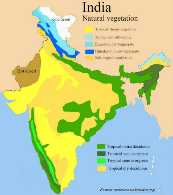
    Types of Natural Vegetation in India

    source

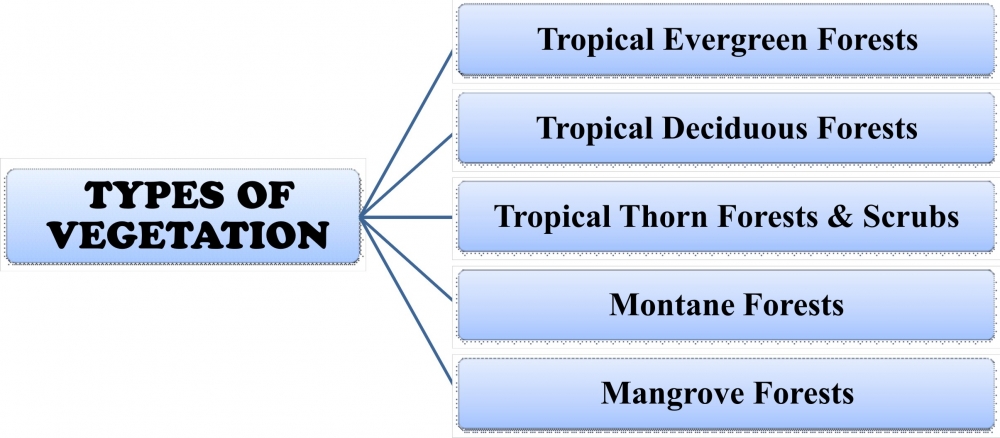
    The following are the principal types of natural vegetation of India:

    (1) Tropical Evergreen Rain Forests,

    (2) Deciduous or Monsoon Type of Forests,

    (3) Dry Deciduous Forests and Scrubs,

    (4) Semi Desert and Desert Vegetation,

    (5) Tidal or Mangrove Forests and


    #1. Tropical Evergreen Forests

    source
    • The tropical evergreen forests usually occur in areas receiving more than 200 cm of rainfall and having a temperature of 15 to 30 degrees Celsius.
    • They occupy about seven per cent of the earth’s land surface and harbours more than half of the world’s plants and animals.
    • They are found mostly near the equator. Region is warm and wet throughout the year.
    • Trees reach great heights up to 60 metres or even above.
    • It has a luxuriant vegetation of all kinds – trees, shrubs, and creepers giving it a multilayered structure.

    In India, evergreen forests are found in the western slopes of the Western Ghats in States such as Kerala and Karnataka. They are also found in hills of Jaintia and Khasi. Some of the trees found in Indian Tropical Forests are rosewood, mahogany and ebony. Bamboos and reeds are also common.

    Common animals found in these forests are elephants, monkey, lemur and deer. The one horned rhinoceros are found in the jungles of Assam and West Bengal.

    #2. Tropical Deciduous Forests:

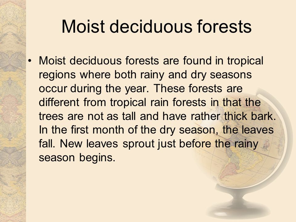
    • They are the most widespread forests of India.
    • Also called the monsoon forests and spread over the region receiving rainfall between 200 cm and 70 cm.
    • Trees of this forest ­type shed their leaves for about six to eight weeks in dry summer.
    • On the basis of the availability of water, these forests are further divided into moist and dry deciduous.

    Moist deciduous forests:

    source
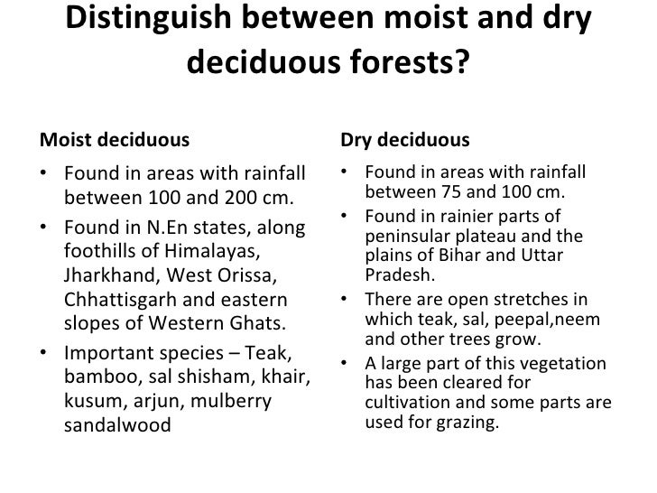
    • It found in areas receiving rainfall between 200 and 100 cm.
    • Exist mostly in the eastern part of the country – northeastern states, along the foothills of the Himalayas, Jharkhand, West Orissa and Chhattisgarh, and on the eastern slopes of the Western Ghats.
    • Teak is the most dominant species of this forest.
    • Bamboos, sal, shisham, sandalwood, khair , kusum, arjun, mulberry are other commercially important species.

    Dry Deciduous Forests:

    source
    • The dry deciduous forests are found in areas having rainfall between 100 cm and 70cm.
    • These forests are found in the rainier parts of the peninsular plateau and the plains of Bihar and Uttar Pradesh.
    • There are open stretches in which Teak, Sal, Peepal, and Neem grow.
    • A large part of this region has been cleared for cultivation and some parts are used for grazing.
    • Common animals found are lion, tiger , pig, deer and elephant. Variety of birds, lizards, snakes, and tortoises are also found here.

    Difference between Dry & Moist Deciduous Forests

    source

    Difference between Evergreen and Deciduous Forests

    source

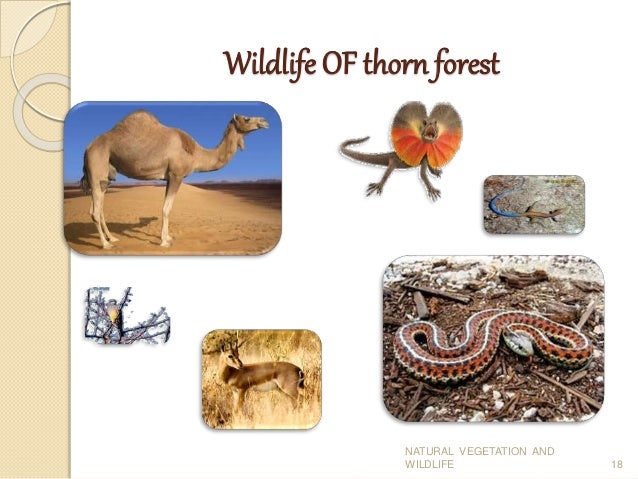
    #3. The Thorn Forests and Scrubs:

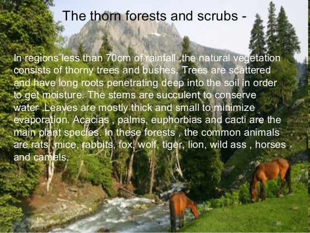
    • In regions with less than 70 cm of rainfall, the natural vegetation consists of thorny trees and bushes.
    • Found in the north­western part of the country including semi­arid areas of Gujarat, Rajasthan, Madhya Pradesh, Chhattisgarh, Uttar Pradesh and Haryana.
    • Acacias, palms, euphorbias and cacti are the main plant species.
    • Trees are scattered and have long roots penetrating deep into the soil in order to get moisture.
    • The stems are succulent to conserve water.
    • Leaves are mostly thick and small to minimize evaporation

    source

    source

    #4. Montane Forests:

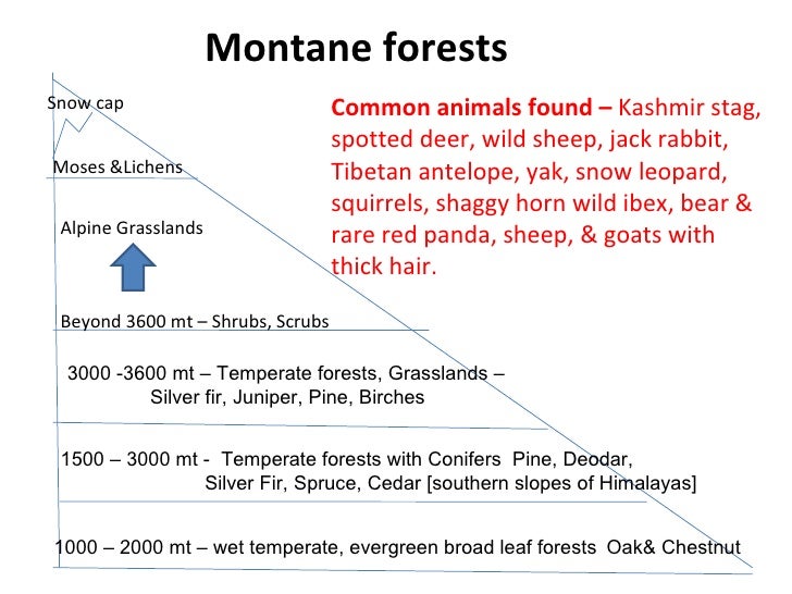
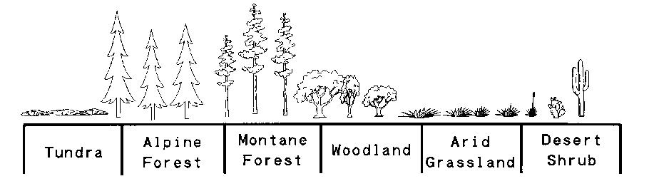
    • In mountainous areas, the decrease in temperature with increasing altitude leads to the corresponding change in natural vegetation.
    • As such, there is a succession of natural vegetation belts in the same order as we see from the tropical to the tundra region.
    • The wet temperate type of forests are found between a height of1000 and 2000 metres.
    • Evergreen broad­leaf trees such as oaks and chestnuts predominate.
    • Between 1500 and 3000 metres, temperate forests containing coniferous trees like pine, deodar, silver fir, spruce and cedar, are found. and they cover mostly the southern slopes of the Himalayas, places having high altitude in southern and north­east India.
    • At higher elevations, temperate grasslands are common.
    • At high altitudes, generally more than 3,600 metres above sea­ level, temperate forests and grasslands give way to the Alpine vegetation.
    • Silver fir, junipers, pines and birches are the common trees of these forests.
    • They get progressively stunted as they approach the snow­line and are used extensively for grazing by nomadic tribes like the Gujjars and the Bakarwals.
    • At higher altitudes, mosses and lichens form part of tundra vegetation.
    • Common animals found in these forests are Kashmir stag, spotted dear , wild sheep, jack rabbit, Tibetan antelope, yak, snow leopard, squirrels, Shaggy horn wild ibex, bear and rare red panda, sheep and goats with thick hair.

    source

    source

    #5. Mangrove Forests:

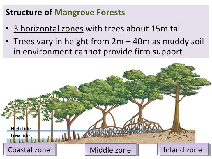
    • Found in the areas of coasts influenced by tides.
    • Mud and silt get accumulated on such coasts.
    • Dense mangroves are the common varieties with roots of the plants submerged under water.
    • The deltas of the Ganga, the Mahanadi, the Krishna, the Godavari and the Kaveri are covered by such vegetation.
    • In the Ganga Brahmaputra delta, sundari trees are found, which provide durable hard timber.
    • Palm, coconut, keora, agar, also grow in some parts of the delta.
    • Royal Bengal Tiger is the famous animal in these forests.
    • Turtles, crocodiles, gharials and snakes are also found in these forests.

    source
    CLICK:-REGISTER & DISCUSS ETHICS CASE STUDIES & YOUR UPSC PREPARATION WITH CD MENTORS FOR FREE
  • The 8 Major Types of Farming Systems in India

    source

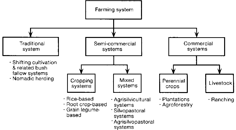
    Based primarily on nature of land, climatic characteristics and available irrigational facilities, the farmers in India practise different types of farming.

    1. Subsistence Farming:

    source
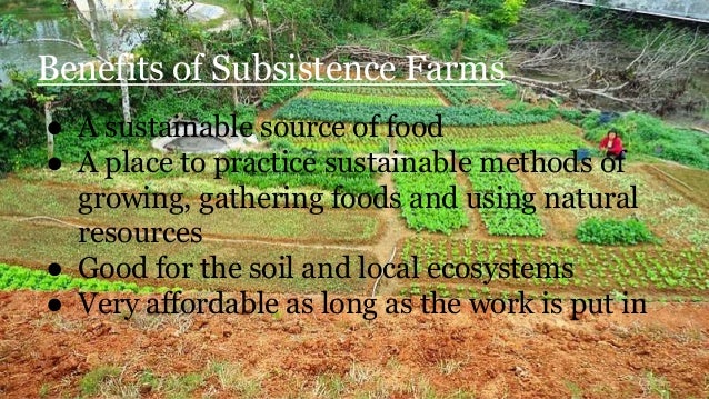
    • Majority of farmers in the country practise subsistence farming.
    • It is characterised by small and scattered land holdings and use of primitive tools.
    • As the farmers are poor, they do not use fertilisers and high yielding variety of seeds in their fields to the extent they should do.
    • Facilities like electricity and irrigation are generally not available to them.

    Features of Subsistence Farming:

    • The whole family works on the farm
    • Most of the work is done manually
    • The farms are small
    • Tradition methods of farming are followed
    • Yield is not very high
    • Most of the yield is consumed by the family with very little surplus for the family

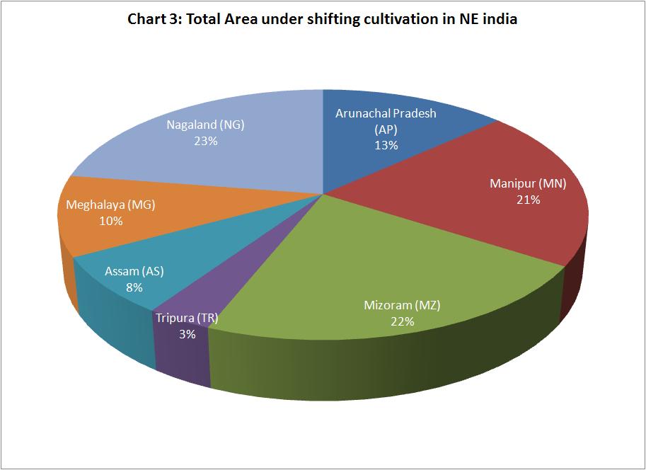
    2. Shifting Agriculture:

    source
    • In this type of agriculture, first of all a piece of forest land is cleared by felling trees and burning of trunks and branches.
    • After the land is cleared, crops are grown for two to three years and then the land is abandoned as the fertility of the soil decreases.
    • The farmers then move to new areas and the process is repeated.
    • Dry paddy, maize, millets and vegetables are the crops commonly grown in this type of farming.

    This practice is known by different name in different regions of India like:

    1. Jhum in Assam,
    2. Ponam in Kerala,
    3. Podu in Andhra Pradesh and Odisha and
    4. Bewar masha penda and Bera in various parts of Madhya Pradesh.
    source

    As far as possible governments have tried to discourage this practice of cultivation by tribals due to wasteful nature such as soil erosion caused by it, when soil erosion caused by it, when soils are not under cultivation.

    3. Plantation Agriculture:

    source
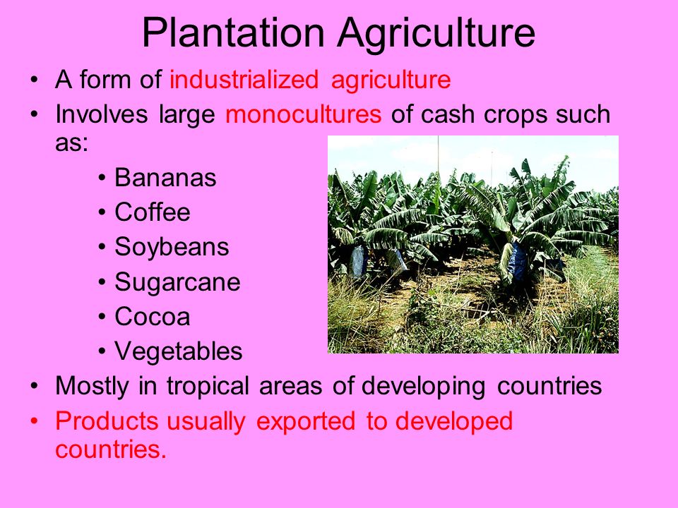
    • Plantation farming is bush or tree farming. It was introduced by the British in the 19th century.
    • It is a single crop farming of rubber, tea, coffee, cocoa, spices, coconut and fruit crops like apples, grapes, oranges, etc.
    • It is capital intensive and demands good managerial ability, technical know-how, sophisticated machinery, fertilisers, irrigation, and transport facilities.
    • Plantation agriculture is an export-oriented agriculture. Most of the crops grown in plantation agriculture have a life cycle of more than two years.
    • Natural rubber, coconuts, oil palm, tea, cocoa, and coffee are all tree crops and take years to mature, but afterwards they are productive for long periods.
    • Plantation agriculture is confined within tropical areas, i.e., both sides of the equator. Plantations exist on every continent possessing a tropical climate.

    Some of the plantations like tea, coffee and rubber have a processing factory within the farm itself or close to it.

    This type of agriculture has developed in hilly areas of north-eastern India, sub-Himalayan West Bengal and in Nilgiri, Anamalai and Cardamom hills in peninsular India.

    4. Intensive Farming:

    In areas where irrigation has been possible, the farmers use fertilisers and pesticides on large scale. They have also brought their land under high yielding variety of seeds. They have mechanised agriculture by introducing machines in various processes of farming.

    Also known as industrial agriculture, it is characterized by a low fallow ratio and higher use of inputs such as capital and labour per unit land area. This is in contrast to traditional agriculture in which the inputs per unit land are lower.

    Remember Intensive Agriculture Development program?

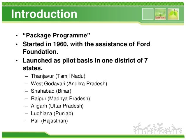
    Intensive Agriculture Development program (IADP) was the first major experiment of Indian government in the field of agriculture and it was also known as a “package programme” as it was based upon the package approach.

    The programme was launched in 1961 after the Community Development Programme lost sheen. The core philosophy was to provide loan for seeds and fertilizers to farmers. Intensive Agriculture Development program was started with the assistance of Ford Foundation.

    The IADP was expanded and later a new Intensive Agriculture Area programme (IAAP) was launched to develop special harvest in agriculture area.

    source

    The IADP was expanded and later a new Intensive Agriculture Area programme (IAAP) was launched to develop special harvest in agriculture area.

    5. Dry Agriculture:

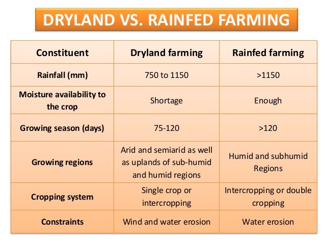
    Dry farming or dry-land farming may be defined as a practice of growing crops without irrigation in areas which receive an annual rainfall of 750 mm – 500 mm or even less.

    source

    Key elements of effective combat with perils of Dryland agriculture

    • Capturing and Conservation of Moisture
    • Effective Use of Available Moisture
    • Soil Conservation
    • Control of Input Costs

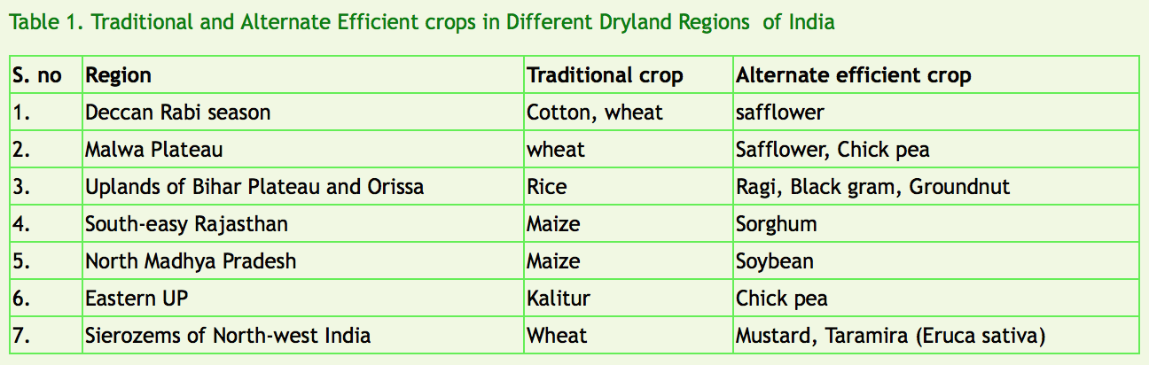
    Dryland agriculture is subject to high variability in areas sown, yields and output. These variations are the results of aberrations in weather conditions, especially rainfall. Alternate crop strategies have been worked out for important regions of the country:

    6. Mixed and Multiple Agriculture:

    • Mixed farming is referred to cultivation of crops and raising of animals simultaneously.
    • The multiple farming is used to denote the practice of growing two or more crops together.
    • In such case a number of crops having varying maturing periods are sown at the same time.
    • This practice is followed is areas having good rainfall or facilities of irrigation.
    source

    7. Crop Rotation:

    source

    This refers to growing of number of Crops one after the other in a fixed rotation to maintain the fertility of the soil. The rotation of crops may be complete in a year in some of the areas while it may involve more than one year’s time is others.

    • Pulses or any leguminous crop is grown after the cereal crops.
    • Legumes have the ability of fixing nitrogen to the soil.
    • Highly fertilizer intensive crops like sugarcane or tobacco are rotated with cereal crops.
    • The selection of crops for rotation depends upon the local soil conditions and the experience and the understanding of the farmers.

    Good time to re-visit the nitrogen cycle again!

    source

    8. Terrace Cultivation:

    • The hill and mountain slopes are cut to form terraces and the land is used in the same way as in permanent agriculture.
    • Since the availability of flat land is limited terraces are made to provide small patch of level land.
    • Soil erosion is also checked due to terrace formation on hill slopes.
    source

    Questions from Previous Year’s Prelims

    1. Which of the following is the chief characteristic of ‘mixed farming’? [UPSC 2012]

    A. Cultivation of both cash crops and food crops
    B. Cultivation of two or more crops in the same field
    C. Rearing of animals and cultivation of crops together
    D. None of the above.

    Ans: C

    2. With reference to Indian agriculture, which one of the following statements is correct? [UPSC 2002]

    A. About 90 per cent of the area under pulses in India is rainfed.
    B. The share of pulses in the gross cropped area at the national level has double in the last two decades
    C. India accounts for about 15 per cent of the total area under rice in the world
    D. Rice occupies about 34 per cent of the gross cropped area of India

    Ans: A

    3. Which one of the following agricultural practices is eco-friendly ? [UPSC 1999]

    A. Organic farming
    B. Shifting cultivation
    C. Cultivation of high-yielding varieties
    D. Growing plants in glass-houses

    Ans: A

    4. What can be the impact of excessive/ inappropriate use of nitrogenous fertilizers in agriculture? [UPSC 2015]
    1. Proliferation of nitrogen-fixing microorganisms in soil can occur.
    2. increase in the acidity of soil can take place.
    3. Leaching of nitrate to the groundwater can occur.
    Select the correct answer using the code given below.

    A. 1 and 3 only
    B. 2 only
    C. 2 and 3 only
    D. 1, 2 and 3

    Ans: C

    5. In India, the problem of soil erosion is associated with which of the following? [UPSC 2015]
    1.Terrace cultivation
    2. Deforestation
    3. Tropical climate
    Select the correct answer using the code given below.

    A. I and 2 only
    B. 2 only
    C. 1 and 3 only
    D. 1, 2 and 3

    Ans: B


  • Census 2011 | The basics and summary of important findings

    Index

    • What is the census?
    • When was the first census in India held
    • Why the census is important
    • Key Findings of the Census of India 2011

    census_2011_image_1

    What is the census?

    Census is nothing but a process of collecting, compiling, analyzing, evaluating, publishing and disseminating statistical data regarding the population. It covers demographic, social and economic data and are provided as of a particular date.

    When was the first census in India held?

    Census operations started in India long back during the period of the Maurya dynasty. It was systematized during the years 1865 to 1872, though it has been conducted uninterruptedly from the year 1881 being a trustworthy resource of information.

    Why is the census important?

    1. The Indian Census is the most credible source of information on Demography (Population characteristics), Economic Activity, Literacy and Education, Housing & Household Amenities, Urbanisation, Fertility and Mortality, Scheduled Castes and Scheduled Tribes, Language, Religion, Migration, Disability and many other socio-cultural and demographic data since 1872. Census 2011 is the 15th National Census of the Country. This is the only source of primary data in the village , town and ward level, It provides valuable information for planning and formulation policies for Central and the State Governments and is widely used by National and International Agencies, scholars, business people, industrialists, and many more.

    2. The delimitation/reservation of Constituencies – Parliamentary/Assembly/Panchayats and other Local Bodies is also done on the basis of the demographic data thrown up by the Census. Census is the basis for reviewing the country’s progress in the past decade, monitoring the ongoing Schemes of the Government and most importantly, plan for the future.

    Key findings of Census of India 2011 (Summary for UPSC Notes)

    Source
    Key Findings Data & Statistics
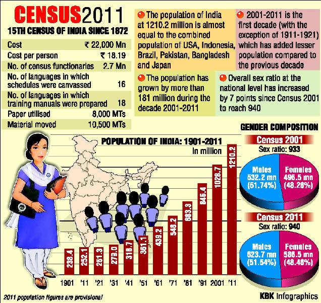
    Total Population (2011) 1.21 billion (an increase of 17.7% from the previous decade).
    Male-Female Population Growth Males: Increased by 90.97 million. Females: Increased by 90.99 million. Growth rate: Females (18.3%) higher than Males (17.1%).
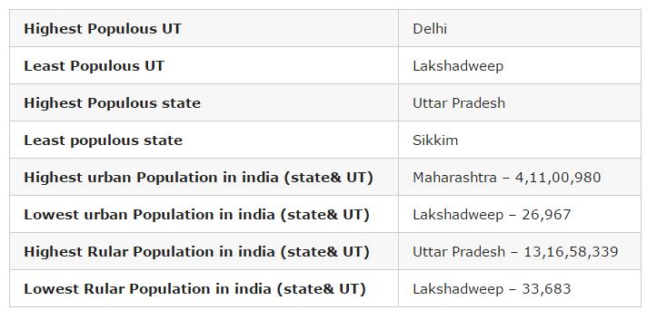
    Rural vs Urban Population Rural: 833.5 million (more than two-thirds). Urban: 377.1 million (urban proportion increased to 31.2% from 17.3% in 1951). Highest urban population in Delhi (97.5%).
    Literacy Rate 73% (up from 64.8% in 2001). Male literacy: 80.9%, Female literacy: 64.6%. Highest literacy rates: Kerala (94%), Lakshadweep (91.8%), Mizoram (91.3%).
    Population Density Increased from 325 (2001) to 382 (2011) per sq. km. Highest density: Delhi (11,320 per sq. km). Lowest: Arunachal Pradesh (17 per sq. km).
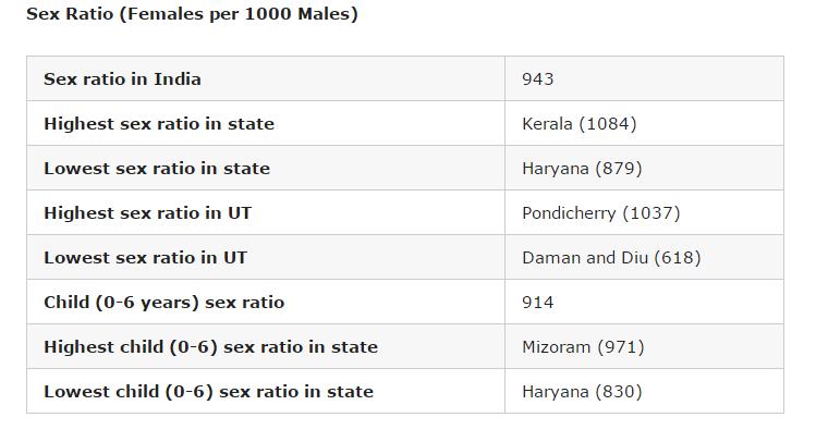
    Sex Ratio 940 females per 1000 males (an increase from 933 in 2001). Highest: Kerala (1,084 females per 1000 males). Lowest: Haryana (879 females per 1000 males).
    Child Population (0-6 years) 164.5 million (0.4% increase from 2001). Child sex ratio: 919 females per 1000 males (a decline from 927 in 2001).
    SC/ST Population SC: 201.4 million (20% increase from 2001). ST: 104.3 million (23.7% increase from 2001).
    Religious Demographics Hindus: 79.8%, Muslims: 14.23%, “No Religion” category: 2.87 million (0.24%).
    Median Marriage Age Men: 23.5 years (up from 22.6 in 2001). Women: 19.2 years (up from 18.2 in 2001).

    1. Population of India as per 2011 Census

    • India’s total population stands at 1.21 billion, which is 17.7 per cent more than the last decade, and growth of females was higher than that of males.
    • There was an increase of 90.97 million males and increase of 90.99 million females. The growth rate of females was 18.3 per cent which is higher than males — 17.1 per cent. India’s population grew by 17.7 per cent during 2001-11, against 21.5 per cent in the previous decade.
    • Among the major states, highest decadal growth in population has been recorded in Bihar (25.4 per cent) while 14 states and Union Territories have recorded population growth above 20 per cent.

    2. Rural and urban population as per 2011 Census Data

    • Altogether, 833.5 million persons live in rural area as per Census 2011, which was more than two-third of the total population, while 377.1 million persons live in urban areas. Urban proportion has gone up from 17.3 per cent in 1951 to 31.2 per cent in 2011. Empowered Action Group (EAG) states have lower urban proportion (21.1 per cent) in comparison to non-EAG states (39.7 per cent).
    • Highest proportion of urban population is in NCT Delhi (97.5 per cent). Top five states in share of urban population are Goa (62.2 per cent), Mizoram (52.1 per cent), Tamil Nadu (48.4 per cent), Kerala (47.7 per cent) and Maharashtra (45.2 per cent).

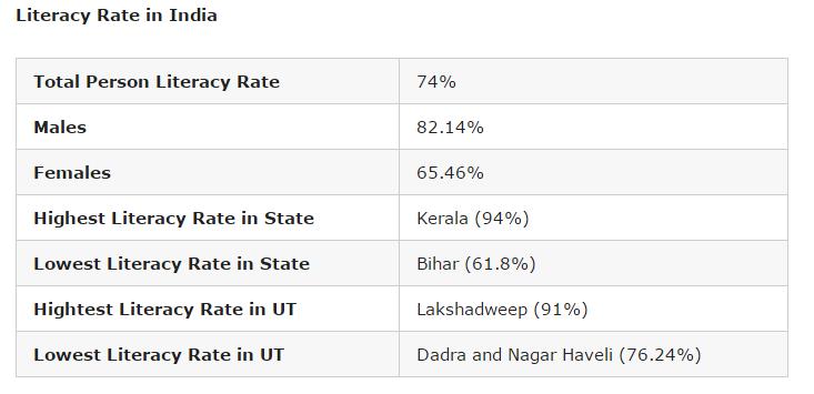
    3. Literacy Rate as per Census of India 2011

    • Literacy rate in India in 2011 has increased by 8 per cent to 73 per cent in comparison to 64.8 per cent in 2001.
    • While male literacy rate stands at 80.9 per cent – which is 5.6 per cent more than the previous census, the female literacy rate stands at 64.6 per cent — an increase of 10.9 per cent than 2001.
    • The highest increase took place in Dadra and Nagar Haveli by 18.6 points (from 57.6 per cent to 76.2 per cent), Bihar by 14.8 points (from 47.0 per cent to 61.8 per cent), Tripura by 14.0 points (from 73.2 per cent to 87.2 per cent)
    • Improvement in female literacy is higher than males in all states and UTs, except Mizoram (where it is same in both males and females) during 2001-11.
    • The gap between literacy rate in urban and rural areas is steadily declining in every census. Gender gap in literacy rate is steadily declining in every census. In Census 2011, the gap stands at 16.3 points.
    • Top five states and UTs, where literacy rate is the highest, are Kerala (94 per cent), Lakshadweep (91.8 per cent), Mizoram (91.3 per cent), Goa (88.7 per cent) and Tripura (87.2).
    • The bottom five states and UTs are Bihar (61.8 per cent), Arunachal Pradesh (65.4 per cent), Rajasthan (66.1 per cent), Jharkhand (66.4 per cent) and Andhra Pradesh (67 per cent).

    4. Census 2011 Population Density Data

    • The density of population in the country has also increased from 325 in 2001 to 382 in 2011 in per sq km. Among the major states, Bihar occupies the first position with a density of 1106, surpassing West Bengal which occupied the first position during 2001.
    • Delhi (11,320) turns out to be the most densely inhabited followed by Chandigarh (9,258), among all states and UT’s, both in 2001 and 2011 Census. The minimum population density works out in Arunachal Pradesh (17) for both 2001 and 2011 Census.

    5. India’s Sex ratio as per 2011 Census

    • The sex ratio of population in the country in 2011 stands at 940 female against 1000 males, which is 10 per cent more than the last census when the number female per thousand male stood at 933. Haryana has the dubious distinction of having the worst male-female ratio among all states while Kerala fares the best.
    • The number of females per 1000 males in Haryana in 2011 stands at 879 followed by Jammu and Kashmir (889 female) and Punjab (895 females).
    • The other two worst-performing states in terms of skewed sex ration are Uttar Pradesh (912 females) and Bihar (918 females).
    • Five top performing states in terms of sex ratio were Kerala (1,084 females), Tamil Nadu (996), Andhra Pradesh (993), Chhattisgarh (991), Odisha (979).

    6. Child population in India as per Census of India 2011

    • Child population in the age of 0 to 6 years has seen an increase of 0.4 per cent to 164.5 million in 2011 from 163.8 million in 2001.
    • The child population (0-6) is almost stationary. In 17 states and UTs, the child population has declined in 2011 compared to 2001.
    • With the declaration of sex ratio in the age group 0-6, the Census authorities tried to bring out the recent changes in the society in its attitude and outlook towards the girl child. It was also an indicator of the likely future trends of sex ratio in the population.
    • There has been a decline of 8 per cent in the sex ratio of 0-6 age group. In 2011, the child sex ratio (0-6) stands at 919 female against 1000 male in comparison to 927 females in 2001.
    • Male child (0-6) population has increased whereas female child population has decreased during 2001-11. Eight states, Jammu and Kashmir, Rajasthan, Uttar Pradesh, Bihar, Jharkhand, Arunachal Pradesh, Mizoram, and Meghalaya have proportion of child population more than 15 per cent.
    • The worst performing states in regard to sex ration in the age group of 0 to 6 years are Haryana (834 females), Punjab (846), Jammu and Kashmir (862), Rajasthan (888) and Gujarat (890).
    • The best performing states are Chhattisgarh (969), Kerala (964), Assam (962), West Bengal (956) Jharkhand (948) and Karnataka (948).

    7. SC/ST data as per 2011 Census Data

    • According to the Census, Scheduled Castes are notified in 31 states and UTs and Scheduled Tribes in 30 states. There are altogether 1,241 individual ethnic groups, etc. notified as SC’s in different states and UT’s.
    • The number of individual ethnic groups, etc. notified as ST’s is 705. There has been some changes in the list of SC’s/ST’s in states and UT’s during the last decade.
    • The SC population in India now stands at 201.4 million, which is 20 per cent more than the last census. The ST population stands at 104.3 million in 2011 – 23.7 per cent more than 2001.

    8. Religious demographics as per Census of India 2011

    The religious data on India Census 2011 was released by the Government of India on 25 August 2015. Hindus are 79.8% (966.3 million), while Muslims are 14.23% (172.2 million) in India. For the first time, a “No religion” category was added in the 2011 census. 2.87 million Were classified as people belonging to “No Religion” in India in the 2011 census. – 0.24% of India’s population of 1.21 billion. Given below is the decade-by-decade religious composition of India till the 2011 census. There are six religions in India that have been awarded “National Minority” status – Muslims, Christians, Sikhs, Jains, Buddhists and Parsis.

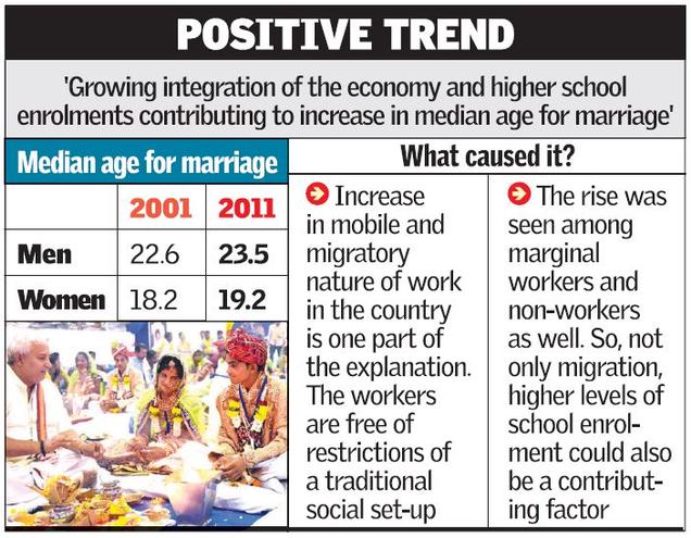
    9. Median marriage age as per Census 2011

    The median age increased for men – from 22.6 (2001) to 23.5 (2011) and for women – from 18.2 (2001) to 19.2 (2011)

    Source

    The next part of the series will cover the 2011 Socio Economic Caste Census (SECC). You must have read about it many times in the news, reading it on Civils Daily will make you clear as to what it’s actually about!

    FAQs

    1. What is the percentage of the child population in India according to Census 2011?

    According to the Census 2011, children aged 0-6 years constituted 13.12% of India’s total population.

    2. What are the important facts from Census 2011?

    • Total Population: 1.21 billion.
    • Male-Female Ratio: 940 females per 1000 males.
    • Literacy Rate: 74.04% (Male: 82.14%, Female: 65.46%).
    • Decadal Growth Rate: 17.64%.
    • Child Sex Ratio: 919 females per 1000 males.

    3. What is the caste-wise population distribution in India as per Census 2011?

    • The caste-based population data is not published as part of Census 2011. However, estimates suggest that Scheduled Castes (SCs) and Scheduled Tribes (STs) constitute around 16.6% and 8.6% of the total population, respectively.

    4. Where can I get a summary of the 2011 Census for UPSC?

    Various summaries and detailed PDF documents on Census 2011 tailored for UPSC preparation are available on government and educational platforms. You can find them by searching “Census 2011 UPSC PDF” or referring to sources like Civilsdaily and NCERT resources

    5. When is the latest Census of India conducted?

    The latest census was planned for 2021, but it has been delayed due to the COVID-19 pandemic. The data collection is still pending as of the last update.

  • Different levels of Diplomacy | Track 1, Track 2, Track 3

    The Ministerial Session of the eighth edition of Delhi Dialogue, the pre-eminent annual Track 1.5 dialogue process for brainstorming on all aspects of the ASEAN-India relationship, took place in the evening of 18 February 2016 at New Delhi.

    We will talk at lengths on the ASEAN-India relationship as we develop our introductory series on IR for IAS further, but today let’s understand diplomacy in its tracks!

    Traditionally, the term “diplomacy” referred to interaction between nation-states. More recently, however, scholars have delineated several levels of diplomacy. Tracks 1 and 2 are the most frequently used terms.

    CLICK:-REGISTER & DISCUSS ETHICS CASE STUDIES & YOUR UPSC PREPARATION WITH CD MENTORS FOR FREE

    #1. Track 1 Diplomacy:

    Official discussions typically involving high-level political and military leaders and focusing on cease-fires, peace talks, and treaties and other agreements. Heads of states meet, have hi-tea, discuss issues and release joint statements etc.


    #2. Track 2 Diplomacy:

    Unofficial dialogue and problem-solving activities aimed at building relationships and encouraging new thinking that can inform the official process.

    Since it is unofficial –  you can expect to see influential academic, religious, and NGO leaders and other civil society actors who can interact more freely than high-ranking officials. Think of Baba Ramdev and Amir Khan trying to chit chat with officials of Pak Foreign ministry, cajoling them into buying an idea (hopefully for more peace and er. yoga!)

    Here’s where we see the emergence of term – Track 1.5 to denote a situation in which official and non-official actors work together to resolve conflicts. Read this press release from MEA in the light of this definition – Ministerial Session of Delhi Dialogue VIII


    #3. Track 3 Diplomacy:

    People-to-people diplomacy undertaken by individuals and private groups. It would not be further from truth if we say that the “aam aadmi” of India does not really hate his counterpart at Pakistan. Beyond the media and political blur, there are a lot of initiatives which get people closer (do we hear bollywood).

    Pakistan loves our films and actors, we love their cuisine and musicians!

    Normally focused at the grassroots level, this type of diplomacy often involves organizing meetings and conferences, generating media exposure, and political and legal advocacy for marginalized people and communities.


    #4. Multitrack Diplomacy:

    A term for operating on several tracks simultaneously, including official and unofficial conflict resolution efforts, citizen and scientific exchanges, international business negotiations, international cultural and athletic activities, and other cooperative efforts.


    Reference – UNITED STATES INSTITUTE OF PEACE

    CLICK:-REGISTER & DISCUSS ETHICS CASE STUDIES & YOUR UPSC PREPARATION WITH CD MENTORS FOR FREE
  • Rule of Law v/s Rule by Law

    This article focuses on bringing clarity to the two very different concepts which look similar at face value.  Sir Ivor Jennings, the famous constitutional historian, characterized the Rule of Law as ‘an unruly horse’.

    First, let’s be clear about what the Rule of Law is not.

    Rule of Law should not be equated with law and order. The breakdown of law and order is a temporary phenomenon.

    Breakdown of the Rule of Law means the collapse of good governance and the breakdown of constitutional machinery in a State.

    Now, let’s see what the Rule of Law is.

    It may be difficult to define the concept with precision but in essence, it signifies a commitment to certain principles and values. Generally, the rule of law is the principle that no one is above the law and treated equally among citizens.

    The Rule of Law symbolizes the quest of civilized democratic societies to combine that degree of liberty without which law is tyranny with that degree of law without which liberty becomes license.

    However high you may be, the law is above you.

    For instance, One may be the Prime Minister or the Speaker or the Imam or the Archbishop or a judge or the Sankaracharya or whoever, all are equally subject to the law. That imparts the element of non-discrimination in the concept of the Rule of Law.

    What are the principles of the Rule of Law?

    It was A.V. Dicey, the English Professor and Constitutional expert, who developed this concept. He defined 3 principles that govern the rule of law.

    1. Supremacy of Law
      No man shall be punished or made to suffer in body or goods except for the violation of the law. Such a violation must be established in an ordinary court of the land and in an ordinary legal manner.
    2. Equality before Law
      No man is above the law and everyone, whatever his condition or rank is, is subject to the ordinary laws of the land. <It means a person can sue or be sued in a court of law>
    3. Predominance of Legal Spirit
      The result of the ordinary law of the land is Constitution. It indicates that the general principles of the constitution are the result of judicial decisions of the courts in England. <However, this principle does not apply in the case of a written constitution. It stands modified in India, where it reads that the constitution is the supreme law of the land & all other laws in order to be legally valid shall conform to the constitution>

    What is the importance of Rule of Law?

    Rule of Law is essential for the protection of human rights.

    This concept changed the mode of administration from “King was Law” to “Law is King”. It is quite essential for the healthy functioning of democracy.

    In its path-breaking judgment in Keshavanand Bharti’s case, our Supreme Court ruled that the Rule of Law is part of the Basic Structure of the Constitution.

    The Constitution in order to preserve the rule of law, has conferred the writ jurisdiction under Art. 32 and Art. 226 on Supreme Court and High Court respectively.

    How Rule of Law is different from Rule of Law?

    It is important not to confuse Rule of Law with rule by law.

    The existence of a law is necessary but that is not sufficient. The law must have a certain core component that guarantees the basic human rights and the human dignity of every person.

    Rule by law can become an instrument of oppression and it can give legitimacy to the enactment of laws that may grossly violate basic human rights.

    Let’s see with examples, how rule by law can be misused

    Nazi Germany put Jews in concentration camps and thereafter sent them to the gas chambers. The justification offered was that there was a law that empowered such acts to be done. But that was rule by law, not the Rule of Law.

    During the apartheid regime in South Africa, repressive and racially discriminatory laws against the black majority were sought to be justified on the basis of enacted laws.

    Let’s see the relevance of the Rule of Law in India

    In India, this concept is implicitly mentioned in the fundamental rights of our constitution. The equality before law (Article 14) includes Rule of Law in itself.

    Indian Constitution grants some exceptions to the Rule of Law.

    What are the exceptions to the Rule of Law in India?

    1. The President/Governor is not answerable to court of law in discharge of his executive functions.
    2. No criminal proceedings whatsoever can be instituted against the President or Governor of the state, while he is in office.
    3. No civil proceedings in which relief is claimed can be filed against President or Governor except after the expiration of a 2-month notice that is served on him.

    Under International laws, the visiting heads of state, heads of govt, ministers, officials, and foreign diplomats who are posted in the country are not subjected to the jurisdiction of local courts in the discharge of their official functions.

    What are the concerns regarding the Rule of Law in India?

    Legal experts have raised their concerns regarding the implementation of the Rule of Law in India. A free democratic society like India cannot have recourse to measures that violate the very essence of the rule of law.

    For instance, a law that permits the killing of suspected terrorists or enables indefinite detention without prior hearing at the absolute discretion of the executive is destructive of the rule of law. Fake encounters have no place in a govt professedly based on the rule of law.

    Therefore, we should strive to instill the rule of law temperament and culture at home and in educational institutions. The aim should be that rule of law becomes the secular religion of all nations based on tolerance and mutual respect.

  • Indian Polity | Timeline : States and UT Reorganization

    After India became independent, its constituent units were classified into 4 distinct categories – Part A, Part B, Part C, Part D. Their composition is as follows

    Part A statesFormer British provincesAn elected governor and state legislature9 states: Assam, Bihar, Bombay, East Punjab, Madhya Pradesh, Madras, Orissa, Uttar Pradesh, and West Bengal
    Part B statesFormer princely states or groups of Covenanting statesRajpramukh (former princes)9 states: Hyderabad, Jammu and Kashmir, Madhya Bharat, Mysore, Patiala and East Punjab States Union (PEPSU), Rajasthan, Saurashtra, Travancore-Cochin, and Vindhya Pradesh
    Part CFormer princely states and provincesChief commissioner10 states: Ajmer, Coorg, Cooch-Behar, Bhopal, Bilaspur, Delhi, Himachal Pradesh, Kutch, Manipur, and Tripura
    Part DUnion TerritoryGovernor appointed by the Indian presidentAndaman and Nicobar Islands
    Part C states were administered by the President through a Chief Commissioner or Lieutenant-Governor.

    1956: States Reorganization Act. Abolished the above 4-fold classification. Part A and Part B were merged. Part C territories – HP(including Bilaspur), Delhi, Manipur, and Tripura were made UTs and the rest merged with their adjoining states. Part D(Andaman & Nicobar Islands) was made a UT.

    Total States: 14
    UT Count: 6

    1960: Bilingual state of Bombay was divided into Maharashtra and Gujrat.

    Gujrat becomes the 15th State.

    Total States: 15
    UT Count: 6

    1961: Dadra and Nagar Haveli, Portuguese colony till 1954 was converted into a UT by the 10th Constitutional Amendment Act. Dadra and Nagar Haveli becomes the 7th UT.

    Total States: 15
    UT Count: 7

    1962: Goa, Daman and Diu were acquired from Portuguese by means of police action in 1961. Constituted as UT by the 12th Constitutional Amendment Act in 1962. They come 8th and 9th UT respectively.

    Total States: 15
    UT Count: 9

    1962: State of Nagaland carved out from the state of Assam by 13th Constitutional Amendment Act in 1962. Nagaland becomes the 16th State.

    Total States: 16
    UT Count: 9

    1962: 4 French establishments – Puducherry, Karaikal, Mahe and Yanam where handed over to India in 1954. Made a UT by the 14th Constitutional Amendment Act in 1962. Puducherry becomes the 10th UT.

    Total States: 16
    UT Count: 10

    1966: Punjab was bifurcated to create Haryana. UT of Chandigargh was formed. Hilly Areas of Punjab were merged with Himachal Pradesh. Haryana becomes the 17th State. Chandigargh becomes the 11th UT.

    Total States: 17
    UT Count: 11

    1970: HP elevated from the status of UT to the status of state. HP becomes the 18th State. The total UT count comes down to 10.

    Total States: 18
    UT Count: 10

    1971: Political Map of NE underwent a Major Change. Manipur, Tripura and Meghayala elevated to the status of state. The total State-count becomes 21.

    Total States: 21
    UT Count: 10

    1975: Referendum held in Sikkim and Sikkim became an integral part of India. 36th Constitutional Amendment made it the 22nd full-fledged state.

    Total States: 22
    UT Count: 10

    1986: Mizoram and Arunachal Pradesh elevated from status of UT to the status of state. The total State-count becomes 24. The total UT-count comes down to 8.

    Total States: 24
    UT Count: 8

    1987: Goa elevated from status of UT to the status of state. Becomes the 25th State. The total UT count comes down to 7.

    Total States: 25
    UT Count: 7

    1991: Delhi becomes the National Capital Territory of Delhi.

    2000: Chhattisgargh(from MP), Uttarakhand(from UP) and Jharkhand(from Bihar) carved out to form independent states. The total State-count is 28.

    Total States: 28
    UT Count: 7

    2014: Andhra Pradesh bifurcated to form Telangana. Becomes the 29th State.

    Total States: 29
    UT Count: 7

  • History | Gandhiji’s 4 Satyagraha

    After his successful stint in South Africa, it was time for Gandhiji to try his tactics in his homeland, India. He tries to experiment with Satyagraha at a smaller scale before he goes for a mass movement. All his experiments were a huge success and thus lay the foundation of the Non-Cooperation movement which shook the British Raj.

    CLICK:-REGISTER & DISCUSS ETHICS CASE STUDIES & YOUR UPSC PREPARATION WITH CD MENTORS FOR FREE
    1. Champaran Satyagraha – 1917

    Gandhiji was persuaded by Raj Kumar Shukla to study the conditions of the Indigo Plantation workers in Champaran, a district in Bihar.

    The system prevalent in the Indigo Plantations was the Tinkathia System*. In this system, the peasants were required to mandatorily cultivate indigo in 3/20th of their land holdings.

    Gandhiji did his research. At the same time, the Govt. appointed a Commission of Inquiry to go into the whole issue and nominated Gandhiji as one of its members. Needless to say, it found the Planters guilty of exploitation. A compromise was reached and Planters were ordered to refund 25% of the amount they had illegally taken.

    1. Ahmedabad Satyagraha – 1918

    This time Gandhiji was dealing with the workers. Due to plague, the mill owners had increased the pay to 75% to attract workers. However, once the plague conditions subsided, the mill owners wanted to bring down the pay to 20%. The workers didn’t agree with this reduction and wanted 50% of the pay to remain. The logic they sited was that WW1 had increased the prices. Gandhiji didn’t want the interest of the industrialist class to be hurt. He tried hard to persuade Ambalal Sarabhai who was his friend but failed. Left with no option, he asked workers to go on a strike. When Gandhiji saw the strike subsiding, he went on a fast. This put pressure on the mill owners who agreed for the 35% increment.

    1. Kheda Satyagraha – 1918

    This is where Gandhiji teams up with Sardar Vallabhbhai Patel to help the cause of peasants. The peasants were in extreme distress as their crop produce had been 1/4th of the original. As per the revenue code, they were entitled for a full concession. However, the Govt. wasn’t willing to let go of their revenues and kept pressurizing the peasants.

    Gandhiji urged all farmers to fight unto death against this injustice of the British. He appealed the rich farmers to support to the poor farmers by not paying revenues despite having the capability. Later the British came out with a policy asking the rich farmers to pay their due voluntarily. (which backfired as no rich farmer willingly wanted to pay revenue)

    1. Rowlatt Satyagraha – 1919

    British, in the name of curbing terrorist violence, had introduced a Bill that severely curtailed the liberties of the Indians. It had provisions for arrest without warrant and detention for 2 years. Gandhiji called for a nation-wide hartal accompanied by fasting and praying. The Movement went in a different direction than what was expected. There were events of violent outbreaks which feared the Govt.

    The Rowlatt Satyagraha was withdrawn on 18th April, 1919 because of the Jaliawala Bagh Massacre that happened on 13th April 1919.

    Gandhiji called it a ‘Himalayan Blunder’. It should be noted that NCM was not the first Nationwide Movement, it was the Rowlatt Satyagraha.

    CLICK:-REGISTER & DISCUSS ETHICS CASE STUDIES & YOUR UPSC PREPARATION WITH CD MENTORS FOR FREE

    *There were two main systems of indigo cultivation – nij and ryoti. A detailed explanation of the same is given in NCERT.

    Ref : http://www.ncert.nic.in/ncerts/l/hess103.pdf

  • Indian Polity | Speaker of the Lok Sabha

    The office of the Speaker is more than merely a presiding officer of the LS. One thing you will notice is that you will not find an exhaustive list of rules and procedures for the Officers of Lok Sabha and Rajya Sabha. That’s because these are offices of trust. We take for granted that when a Member is appointed a speaker, he/she keeps his party allegiance aside and acts in an impartial manner.

    Powers of the Speaker

    The Office of the Speaker is a very powerful one. He derives his powers from three sources – a. The Constitution, b. The Rules of Procedures and Conduct of Business of Lok Sabha and c. The Parliamentary Convention(residuary powers that are unwritten or unspecified).

    1. He is the sole authority to decide whether a Bill is a Money Bill or not. This decision of his cannot be challenged.

    The present Parliament is the best example to demonstrate how important this power can be. The Govt. enjoys a majority in the LS but not in the RS. Hence they are unable to get a lot of Bills passed. Our FM remarked that certifying the Bills as Money Bills are the only way to get them passed.

    *The Speaker has to consult Article 110 to mark a Bill as Money Bill. So it’s not entirely his discretion.

    1. He presides over the joint setting of the two houses. This privilege doesn’t belong to the Chairman of the RS. If the Speaker is absent, it goes to the Dy. Speaker of the LS. If the Dy. Speaker is absent, it goes to the Vice Chairman of the RS.
    2. The Speaker enjoys a special relationship with the Parliamentary Committees. All the Joint Parliamentary Committees are appointed by the Speaker and they report to him directly. Further, the Speaker nominates various members to these committees. If the Speaker himself is a Member, he becomes the ex-officio Chairman.
    3. The Office of the Speaker is retained till the 1st meeting of the next LS. All other Members cease to be in office once the LS dissolves.
    4. Special Role in Anti-Defection law. The Speaker has to accept the resignation of any Member of the House. This is to ensure that the resignation is voluntary. This decision is final but is open to Judicial Review. Ref: PRS India