Mains Ready By December. Smash Mains & Smash PYQ Admissions Open

GS Paper: GS3-18.Conservation, Environmental Pollution and Degradation, Environmental Impact Assessment.

  • [18th March 2026] The Hindu OpED: A bit of blur over India’s new carbon credit plan

    PYQ Relevance[UPSC 2025] What is Carbon Capture, Utilization and Storage (CCUS)? What is the potential role of CCUS in tackling climate change?Linkage: The PYQ covers climate change mitigation and environmental technology (GS 3), especially emission reduction strategies like CCUS. The article applies this through India’s CCUS-focused carbon credit policy, highlighting tension with agriculture-based carbon markets.

    Mentor’s Comment

    India’s Carbon Capture, Utilization, and Storage (CCUS) initiative aims to reduce greenhouse gas emissions to meet 2070 net-zero targets, focusing on high-emitting industrial sectors. The Union Budget 2026-27 announced a ₹20,000 crore scheme to scale up CCUS deployment, specifically targeting power, steel, cement, refineries, and chemical industries. The Budget 2026 announcement highlights the tension between industrial decarbonisation via CCUS and nature-based carbon markets involving agriculture. This raises issues of policy clarity, sectoral prioritisation, and climate governance design.

    What is the core objective of India’s carbon credit plan?

    1. Industrial Decarbonisation Focus: Targets sectors like power, steel, cement, refineries, and chemicals where emissions are concentrated and difficult to eliminate.
    2. CCUS Deployment: Ensures capture of CO₂ from industrial flue gases and its utilization or storage underground.
    3. Technology-led Transition: Supports R&D roadmap released by Department of Science and Technology (Dec 2025).
    4. Budgetary Commitment: ₹20,000 crore over five years for large-scale CCUS deployment.

    Why is agriculture excluded from CCUS strategy?

    1. Emission Characteristics: Agricultural emissions (methane, nitrous oxide) are diffuse and biologically mediated.
    2. Technological Limitation: CCUS is suited for point-source emissions, not dispersed sources like farms.
    3. Policy Segregation: Clear distinction between CCUS (industrial) and Carbon Dioxide Removal (CDR) via soil, biochar, agroforestry.
    4. Role of Agriculture: Positioned under carbon sequestration pathways, not industrial capture.

    What is causing confusion around ‘farmer carbon credits’?

    1. Terminology Overlap: Use of “carbon credit programme” creates perception of inclusivity across sectors.
    2. Parallel Narratives: Media and discourse suggest farmers can directly earn credits under Budget allocation.
    3. Existing Voluntary Markets: Agriculture and forestry projects already generate credits for domestic and global buyers.
    4. Policy Communication Gap: Lack of clear distinction between regulated compliance markets and voluntary carbon markets.

    What are the implications of prioritising CCUS over agriculture?

    1. Industrial Competitiveness: Supports decarbonisation of sectors contributing ~25% of India’s emissions.
    2. Net-Zero Alignment: Essential for achieving India’s climate commitments.
    3. Missed Rural Opportunity: Delays monetisation of agriculture’s carbon sequestration potential.
    4. Fiscal Prioritisation: Directs public funds toward capital-intensive technologies instead of nature-based solutions.

    Can agriculture-based carbon markets emerge as a parallel opportunity?

    1. Soil Carbon Sequestration: Enhances carbon storage through regenerative practices.
    2. Agroforestry Potential: Integrates trees into farming systems to generate carbon credits.
    3. Private Sector Initiatives: Pilot programmes compensate farmers for sustainable practices.
    4. Policy Requirement: Needs separate funding, institutional frameworks, and certification mechanisms.

    What policy approach is required to resolve the ambiguity?

    1. Clear Sectoral Demarcation: Separates ‘smokestack’ (industrial) and ‘soil’ (agriculture) carbon pathways.
    2. Dedicated Agricultural Policy: Establishes structured carbon farming programme with incentives.
    3. Market Development: Creates trusted domestic carbon market for agriculture credits.
    4. Communication Clarity: Ensures alignment between policy design and public narrative.

    Conclusion

    India’s carbon credit framework reflects a dual transition challenge: industrial decarbonisation through CCUS and agricultural transformation through carbon sequestration. Policy clarity, sector-specific instruments, and institutional coherence are essential to avoid misaligned expectations and unlock full climate and economic potential.
  • Wild Buffalo Translocation: Kaziranga to Kanha Initiative

    Why in the News

    Authorities have planned to translocate ~50 Asiatic wild water buffaloes from Kaziranga National Park to Kanha Tiger Reserve in a phased manner, starting with a smaller group.

    About the Species

    • Asiatic Wild Water Buffalo
      • Scientific name: Bubalus arnee
      • Status: Endangered (IUCN)
      • India holds major global population

    Key Details of the Plan

    • Total planned: ~50 buffaloes
    • Initial phase: 5–15 individuals
    • Method:
      • Tranquilization and capture
      • Gradual relocation after feasibility checks

    Why Translocation is Being Done?

    • Species Conservation: Avoids over-concentration in one area
      • Reduces risk from: Disease outbreaks and Natural disasters.
    • Kanha Tiger Reserve historically had wild buffaloes
      • Aim: restore lost populations
    • Genetic Diversity: Helps maintain: Healthy breeding populations and Reduced inbreeding.

    Why Kaziranga?

    • Hosts 1000+ wild buffaloes
    • One of the strongest populations globally
    • Suitable as a source population

    Why Kanha?

    • Suitable: Habitat (grasslands + water sources)
    • Part of central Indian landscape restoration
    [2017] According to the Wildlife (Protection) Act, 1972, which of the following animals cannot be hunted by any person except under some provisions provided by law? 
    1. Gharial Indian 
    2. Wild ass 
    3. Wild buffalo 
    Select the correct answer using the code given below: 
    (a) 1 only (b) 2 and 3 only (c) 1 and 3 only (d) 1, 2 and 3
  • India Submits First National Report on Nagoya Protocol (ABS)

    Why in the News?

    India has submitted its First National Report (NR1) on the implementation of the Nagoya Protocol (ABS) to the Convention on Biological Diversity (CBD) on 27 February 2026, fulfilling obligations under Article 29.

    Key Highlights of the Report

    1. Reporting Period

    • Covers 1 November 2017 to 31 December 2025
    • Earlier Interim Report submitted in 2017

    2. Legal & Institutional Framework

    • Based on: Biological Diversity Act, 2002, Biological Diversity Rules, 2024 and ABS Regulations, 2025. 
    • Three-tier structure:
      • National Biodiversity Authority (NBA)
      • State Biodiversity Boards (SBBs) / UT Biodiversity Councils
      • Biodiversity Management Committees (BMCs)
    • 2,76,653 BMCs established → strong grassroots participation

    3. Access and Benefit Sharing (ABS) Performance

    • Total approvals (2017–2025): 12,830
      • NBA: 5,913 approvals (research, IPR, commercial use, etc.)
      • SBBs/UTBCs: 6,917 approvals (commercial utilization)

    4. Global Leadership in Compliance

    • 3,556 IRCCs (Internationally Recognised Certificates of Compliance) published
    • Accounts for over 60% of global total
    • Shows leadership in transparency under Nagoya Protocol

    5. Financial Benefits Generated

    • ₹216.31 crore mobilised through NBA approvals
      • ₹139.69 crore disbursed to: Local communities, Farmers, and Traditional knowledge holders
    • ₹51.96 crore generated via SBBs/UTBCs

    6. Non-Monetary Benefits

    • 395 approvals included: Capacity building, Technology transfer, Training and Collaborative research. 

    7. Monitoring of Foreign Biological Resources

    • 41 declarations received for use of foreign bioresources
    • Ensures compliance with international ABS norms

    8. Capacity Building & Awareness

    • 2,56,393 individuals trained
    • Through: 3,724 workshops and 600+ capacity-building initiatives

    9. Strategic Contribution

    • Supports Target 13 of India’s NBSAP (National Biodiversity Strategy and Action Plan)
    • Strengthens: Biodiversity conservation, Livelihood security, and Community participation
    [2025] Consider the following statements: 
    1. In India, the Biodiversity Management Committees are key to the realisation of the objectives of the Nagoya Protocol. 
    2. The Biodiversity Management Committees have important functions in determining access and benefit sharing, including the power to levy collection fees on the access of biological resources within its jurisdiction. 
    Which of the statements given above is/are correct? 
    (a) 1 only (b) 2 only (c) Both 1 and 2 (d) Neither 1 nor 2
  • New Fish Species Discovered: Butis bargabhimae in West Bengal

    Why in the News

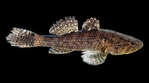
    Scientists have discovered a new estuarine fish species, named Butis bargabhimae, in the Rupnarayan River near Tamluk.

    About the Species

    1. Classification

    • Family: Butidae (gudgeon gobies)
    • Habitat: Brackish water (estuaries)
    • Found where rivers meet the sea

    2. Discovery Process

    • Time: 2022–2024
    • Institutions: Tamralipta Mahavidyalaya and Vidyasagar University.
    • Method:
      • Field collection by local fishermen
      • Morphological + DNA analysis

    Unique Features

    • Presence of interorbital scales (between eyes)
    • Additional auxiliary body scales
    • Distinct light and dark bands on pectoral fins
    • DNA similarity only ~86% with closest relatives
    • Confirms it as a new species

    Naming Significance

    • Named after Bargabhima, a local deity of Tamluk
    • Reflects link between biodiversity and cultural heritage

    Scientific Importance

    • Taxonomic Clarity: Helped correct misidentification of similar species in:
      • India
      • Bangladesh
    • Role of DNA Barcoding: Shows importance of genetic tools in species identification
    • Hidden Biodiversity: Suggests many undiscovered species in Indian rivers and estuaries
    [2022] DNA Barcoding can be a tool to: 
    1. Assess the age of a plant or animal. 
    2. Distinguish among species that look alike. 
    3. Identify undesirable animal or plant materials in processed foods. 
    Select the correct answer using the code given below: 
    (a) 1 only (b) 3 only (c) 1 and 2 (d) 2 and 3
  • ‘Super El Niño’ Alert: Risk of Record Global Heat

    Why in the News

    Forecasters, including NOAA Climate Prediction Center, warn of a possible El Niño in 2026, with chances it could intensify into a “super El Niño”, potentially pushing global temperatures to new highs.

    What is El Niño?

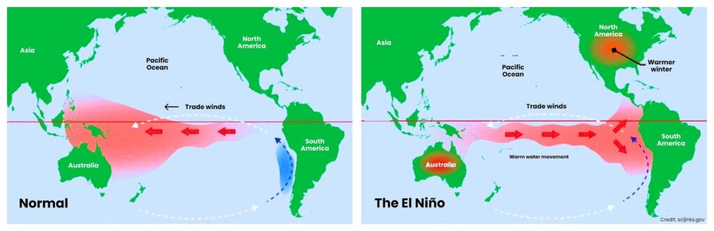
    • A warm phase of the El Niño–Southern Oscillation (ENSO)
    • Occurs when Pacific Ocean surface waters become warmer than normal

    What is a “Super El Niño”?

    • When sea surface temperature rises ≥ 2°C above average
    • Much stronger than normal El Niño
    • Rare events: Last major one: 2015–16

    Current Situation

    • Present phase: La Niña (cool phase) is ending
    • Forecast: ~62% chance of El Niño by mid-2026 and ~15% chance of super El Niño

    How El Niño Works

    • Warm water shifts toward eastern Pacific
    • Weakens trade winds
    • Alters global weather systems
    [2011] La Niña is suspected to have caused recent floods in Australia. How is La Niña different from El Niño? 
    1. La Niña is characterized by unusually cold ocean temperature in the equatorial Indian Ocean whereas El Niño is characterized by unusually warm ocean temperature in the equatorial Pacific Ocean. 
    2. El Niño has an adverse effect on the southwest monsoon of India, but La Niña has no effect on monsoon climate. 
    Select the correct answer: 
    (a) 1 only (b) 2 only (c) Both 1 and 2 (d) Neither 1 nor 2
  • [17th March 2026] The Hindu OpED: Belem as a test of new model of forest finance

    PYQ Relevance[UPSC 2021] Describe the major outcomes of the 26th session of the Conference of the Parties (COP) to the UNFCCC. What are the commitments made by India in this conference?Linkage: TFFF emerges from COP30 processes, reflecting evolving climate finance architecture under UNFCCC, especially beyond traditional commitments like REDD+ and Glasgow pledges.

    Mentor’s Comment

    The Tropical Forest Forever Facility (TFFF) represents a paradigm shift in climate finance architecture by institutionalizing payments for forest conservation. However, it raises fundamental questions about governance, equity, and the role of indigenous communities. The Belém model provides critical insights into future global climate financing frameworks.

    What is Tropical Forest Forever Facility (TFFF)?

    The Tropical Forest Forever Facility (TFFF) is a Brazil-led global initiative designed to reward countries for maintaining standing tropical forests. Set to launch at COP30, this multi-billion-dollar fund seeks to raise $125 billion (25% public, 75% private) to generate annual returns that provide continuous financial incentives for forest conservation, aiming to make standing forests more valuable than felled ones. 

    Key Aspects of the TFFF:

    1. Funding Goal: $125 billion, with early contributions exceeding $5.5 billion from countries like Brazil, Indonesia, Norway, and Colombia.
    2. Mechanism: The initiative combines public and private investment, investing in a portfolio of bonds. The annual profits are then paid out to countries that effectively protect their forests, verified by satellite data.
    3. Indigenous Support: The facility mandates that at least 20% of the funds must go to Indigenous Peoples and Local Communities (IPLCs).
    4. Focus: It focuses on rewarding nations with existing low deforestation rates to keep forests standing, rather than only rewarding reduction. 

    Objectives:

    1. Permanent Conservation: Creating a self-sustaining financial model for long-term conservation rather than temporary projects.
    2. Economic Value: Assigning value to the standing forest ecosystem.
    3. Climate Action: Contributing to a 1.5°C goal by halting tropical deforestation.

    What distinguishes TFFF from earlier forest finance models?

    1. Shift in Approach: Rewards standing forests, not just avoided deforestation.
    2. Financial Structure: Ensures returns on investments, unlike donation-based REDD+ mechanisms.
    3. Scale of Funding: Mobilizes $5.5 billion initial commitments, including $3 billion from Norway.
    4. Performance Incentives: Mandates 20% of payments for indigenous and local communities.
    5. Participatory Design: Incorporates inputs from 400+ community leaders globally.

    Does the TFFF ensure inclusive and equitable governance?

    1. Governance Gap: Indigenous groups lack voting rights in core decision-making bodies.
    2. Power Asymmetry: Central governments retain control over fund allocation.
    3. Equity Concerns: Raises questions on true decentralization of financial authority.
    4. Institutional Risk: Weak local accountability may lead to elite capture of funds.
    5. Structural Inclusion Limits: Participation remains consultative, not decision-binding.

    Why is the TFFF being criticized as “colonial” in design?

    1. Intermediary Dominance: Benefits financial intermediaries over forest-dependent communities.
    2. Return-Oriented Model: Prioritizes financial returns over ecological outcomes.
    3. Structural Drivers Ignored: Fails to address agribusiness expansion, mining, oil extraction.
    4. Superficial Conservation: Risks rewarding preservation without reducing exploitation pressures.
    5. Narrative Control: Reinforces global North-South financial dependency patterns.

    Can financial mechanisms alone address forest degradation?

    1. Systemic Pressures: Infrastructure, extractive industries, and agriculture drive deforestation.
    2. Insufficient Funding: $4 per hectare (earlier proposals) inadequate for ecosystem services.
    3. Policy Disconnect: Financial flows do not align with land-use regulation reforms.
    4. Local Impact Risk: Funds may bypass communities without strong governance structures.
    5. Economic Trade-offs: Conservation competes with high-revenue extractive activities.

    How central are indigenous land rights to forest conservation?

    1. Land Rights Assertion: Indigenous communities demand recognition of territorial sovereignty.
    2. Exclusion Concerns: Many feel excluded from decision-making affecting their lands.
    3. Survival Linkage: Forest protection is tied to livelihoods and cultural identity.
    4. Global Advocacy: Calls for long-term funding supporting community governance models.
    5. Risk of Displacement: Weak safeguards may lead to land alienation and displacement.

    What institutional innovations accompany the TFFF?

    1. Digital Platform: Facilitates TFFF eligibility assessment and transparency mechanisms.
    2. Global Partnerships: Collaborates with UNDP, FAO, WWF, and GATC.
    3. Capacity Building: Supports technical assistance and peer collaboration.
    4. Conflict Safeguards: Ensures independence from governing structures to avoid conflicts of interest.
    5. Inclusion Framework: Promotes knowledge-sharing and participatory governance models.

    What determines the success of the Belém model?

    1. Delivery Mechanisms: Strong institutions ensure efficient and transparent fund utilization.
    2. Local Accountability: Strengthens community-level governance structures.
    3. Rights Integration: Secures indigenous land rights alongside financial flows.
    4. Structural Reform: Aligns conservation with broader economic and land-use policies.
    5. Outcome Orientation: Ensures funds translate into measurable ecological protection.

    Conclusion

    The TFFF represents a transition toward investment-based conservation finance, but its credibility depends on equity, governance, and structural reforms. Without integrating indigenous rights and accountability mechanisms, financial innovation alone cannot ensure sustainable forest conservation.

  • Rare ‘Dual-Sex’ Crab Discovered in Silent Valley

    Why in the News

    A rare freshwater crab species, Vela carli, found in Silent Valley National Park, has been discovered showing both male and female biological traits.

    What was discovered?

    • Scientists found three crabs exhibiting dual sexual characteristics
    • The condition is called Gynandromorphy
    • Example in this case:
    • Some body parts had male reproductive organs
    • Others had female features (gonopores)

    What is Gynandromorphy?

    • A rare biological condition where: An organism shows both male and female characteristics.
    • Usually caused by: Errors during cell division (chromosomal distribution). 
    • Important distinction:
      • Not hermaphroditism (where both reproductive organs function normally)
      • Instead, it is a mosaic of male and female tissues

    About Vela Carli

    • Vela carli is a freshwater crab species endemic to India, specifically found in the Central Western Ghats, one of the world’s richest biodiversity hotspots.
    [2013] Consider the following pairs: National Park : River flowing through the Park Corbett National Park : Ganga Kaziranga National Park : Manas Silent Valley National Park : Kaveri Which of the above pairs is/are correctly matched? (a) 1 and 2 (b) 3 only (c) 1 and 3 (d) None
  • [16th March 2026] The Hindu OpED: Building India’s climate resilience with water at the core

    PYQ Relevance[UPSC 2017] Climate Change is a global problem. How India will be affected by climate change? How Himalayan and coastal states of India will be affected by climate change?Linkage: Climate change in India largely manifests through water stress, floods, glacial melt, and sea-level rise. The article links these impacts to Himalayan river instability and coastal aquifer salinisation, highlighting regional climate vulnerability.

    Why in the News?

    The COP30 Climate Summit in Belém (Brazil, 2025) introduced the first global adaptation indicators integrating Water, Sanitation and Hygiene (WASH) systems into climate accountability frameworks. Now there is a major shift in global climate governance: water systems are emerging as the central pillar of climate resilience. The outcomes of the UN Climate Conference COP30 and the Belém Adaptation Indicators place water management, sanitation, and hydrological governance at the core of adaptation strategies.

    How does climate change manifest primarily through water systems in India?

    1. Hydrological Disruptions: Climate change alters rainfall patterns, leading to extreme floods and prolonged droughts affecting urban and rural economies.
    2. Glacial Melt Impact: Himalayan glacier retreat destabilizes river systems, affecting long-term water availability for major rivers like the Ganga and Brahmaputra.
    3. Saline Intrusion: Rising sea levels cause salinisation of coastal aquifers, contaminating freshwater sources in coastal regions.
    4. Agricultural Vulnerability: Agriculture contributes ~40% of anthropogenic methane emissions, particularly from rice cultivation, livestock systems, and organic waste.
    5. Food Security Threats: Erratic monsoon cycles disrupt crop productivity and irrigation systems.

    What are Belém Adaptation Indicators?

    1. The Belém Adaptation Indicators are a set of 59-60 voluntary, global measures adopted at the COP30 climate summit in Belém, Brazil (scheduled for November 2025) to track how well countries are adapting to climate change. 
    2. Developed through a two-year UN process under the UAE-Belém Work Programme, they aim to provide a shared, practical language for monitoring resilience against climate impacts like floods, droughts, and heatwaves.

    Key Features of the Belém Adaptation Indicators are as follows:

    1. Purpose: To monitor progress toward the Global Goal on Adaptation (GGA) adopted under the Paris Agreement, focusing on whether communities are becoming safer and better able to cope with climate threats
    2. Focus Areas: The measures look at essential sectors such as water security, food systems, health, housing, early warning systems, ecosystems, and local economies
    3. Scope: The indicators emphasize protecting vulnerable populations, including women, indigenous groups, and people with disabilities
    4. Voluntary Nature: They are designed to be flexible rather than a rigid top-down mandate, allowing countries to adapt them to their national circumstances.

    How do Belém Adaptation Indicators redefine climate governance?

    1. Climate-Resilient Water Systems: Focus on reducing water scarcity and increasing resilience against floods and droughts.
    2. Universal Drinking Water Access: Ensures safe drinking water availability for all communities.
    3. Climate-Resilient Sanitation Infrastructure: Strengthens sanitation systems capable of functioning during extreme climate events.
    4. Multi-Hazard Early Warning Systems: Establishes universal early warning coverage by 2027.
    5. Hydrometeorological Capacity: Strengthens meteorological monitoring and national vulnerability assessments by 2030.

    How is India strengthening water governance to build climate resilience?

    1. Institutional Consolidation: Establishment of the Ministry of Jal Shakti (2019) integrates water governance across sectors.
    2. Water Vision 2047: Aligns national water policy with sustainability, equity, and climate resilience goals.
    3. Aquifer Mapping Programme: National Aquifer Mapping and Management Programme (NAQUIM 2.0) advances aquifer-level planning based on hydrogeological data.
    4. River Rejuvenation: National Mission for Clean Ganga (NMCG) expands focus beyond sewage treatment to biodiversity restoration and river basin management.
    5. Integrated Water Management: Encourages linking scientific hydrology with policy planning.

    What systemic risks threaten India’s climate-water resilience?

    1. Unequal Water Distribution: Water scarcity remains acute and unevenly distributed across regions.
    2. Water-Linked Disasters: Most climate disasters in India are water-related (floods, droughts, cyclones).
    3. Fragile Adaptation Finance: Global climate finance pathways remain uncertain despite projections of $1.3 trillion annually by 2035.
    4. Recovery Bias: Lack of predictable finance shifts focus toward post-disaster recovery rather than long-term resilience planning.
    5. Infrastructure Stress: Water supply systems require climate stress testing and diversification of water sources.

    Why is digital fragmentation a challenge for climate-water governance?

    1. Fragmented Data Systems: Hydrological and meteorological datasets remain distributed across institutions without integration.
    2. Limited AI-Driven Decision Support: Despite large datasets, real-time AI integration in governance remains weak.
    3. Planning Disconnect: Water data is rarely linked to budgeting, crop advisories, insurance mechanisms, or disaster response systems.
    4. Need for Interoperable Platforms: Integration of hydrological data, crop advisory systems, insurance frameworks, and financial flows is essential.

    How can India lead global climate adaptation through water governance?

    1. Policy Convergence: Align national missions such as drinking water coverage, irrigation efficiency, and urban water reforms with climate adaptation.
    2. Digital Public Infrastructure: Utilize India’s strength in digital governance systems to integrate climate-water datasets.
    3. Operational Adaptation: Shift from infrastructure creation to functional system resilience.
    4. Global South Leadership: Demonstrate scalable climate adaptation models applicable to other developing countries.

    Conclusion

    Water systems are emerging as the operational backbone of climate adaptation. India possesses strong institutional foundations, including water governance reforms, digital infrastructure, and river restoration programmes. However, translating policy ambition into measurable climate resilience requires integrating hydrological data, strengthening climate finance, and ensuring equitable water distribution. By aligning national missions with global adaptation frameworks, India can emerge as a leader in climate-resilient water governance for the Global South.

  • Ice patches on melting glaciers greater threat than thought: ISRO scientists

    Why in the News

    A new study by scientists from the Indian Space Research Organisation has identified exposed ice patches on retreating Himalayan glaciers as a key precursor to flash floods. The study examined the August 5, 2025 Dharali flash flood in Uttarakhand that killed nine people and devastated settlements along the Bhagirathi river valley. Satellite imagery revealed exposed ice patches in the nivation zone of the Srikanta glacier shortly before the disaster. (Nivation is defined as the erosion of the ground beneath and around a snow bank, primarily resulting from the processes of alternate freezing and thawing.) This indicates accelerated deglaciation and unstable cryosphere conditions. This finding marks an important shift in understanding Himalayan hazards: disasters may originate not only from glacial lake outburst floods (GLOFs) but also from smaller, previously overlooked cryospheric instabilities linked to warming temperatures.

    What are exposed ice patches?

    1. Exposed ice patches are areas of ancient, stable ice that have become visible on the surface of a glacier or mountain slope after their protective covering of seasonal snow and firn (intermediate ice) has thinned or melted away. 
    2. Unlike the main body of a glacier, which flows like a slow-moving river, these patches are often stationary and act as “prehistoric freezers”

    Reasons for their formation are as follows:

    1. Thinning Insulation: Warmer temperatures reduce the layers of snow and firn that normally insulate the deeper ice.
    2. Ablation: During the ablation period (when a glacier loses more ice/snow than it gains), these patches may emerge on steep, shaded slopes, particularly in nivation hollows where snow traditionally lingers year-round.
    3. Wind Scouring: In some regions, like Antarctica, strong winds can strip away top layers to reveal bright blue patches of older, denser ice.

    How do exposed ice patches signal accelerated glacier retreat in the Himalayas?

    1. Deglaciation indicator: Exposed ice patches in the Srikanta glacier’s ablation zone indicate thinning seasonal snow and firn cover due to rising temperatures.
    2. Satellite evidence: Pre-event satellite imagery showed persistent exposed ice patches on north-northeast facing slopes where snow normally accumulates.
    3. Cryosphere instability: Loss of insulating snow layers accelerates melting and structural weakening of glaciers.
    4. Regional warming effect: Similar processes have been documented in other warming cryosphere regions including the Canadian Arctic and Greenland.

    What role did nivation processes play in triggering the Dharali flash flood?

    1. Nivation process: Erosion of ground beneath snowbanks caused by alternate freezing and thawing cycles.
    2. Formation of nivation hollows: Repeated snow accumulation creates depressions which deepen over time.
    3. Structural instability: In steep Himalayan terrain, nivation hollows accumulate ice, meltwater, and debris.
    4. Trigger mechanism: Collapse of an exposed ice patch within the nivation zone of the Srikanta glacier released meltwater and debris.
    5. Result: Sudden downstream debris flow triggered the Dharali flash flood.

    Why are Himalayan glaciers increasingly vulnerable to cryosphere hazards?

    1. Rapid glacier retreat: Himalayan glaciers are losing ice due to rising regional temperatures.
    2. Snow and firn thinning: Seasonal snow cover that stabilizes glaciers is shrinking.
    3. Steep mountain terrain: High relief areas amplify instability and debris flow risks.
    4. Glacier fragmentation: Smaller unstable ice masses form as glaciers shrink.
    5. Emerging hazard types: Hazards now include not only GLOFs but also ice collapses, debris flows, and cryosphere mass movements.

    How do satellite observations improve early warning systems for glacier disasters?

    1. Pre-event detection: Satellite imagery identified exposed ice patches before the Dharali flood.
    2. Landscape monitoring: Remote sensing helps track glacier retreat and unstable cryosphere zones.
    3. Hazard reconstruction: Earth observation data reconstructs sequences leading to disasters.
    4. Early warning potential: Monitoring exposed ice patches could provide advance signals of possible cryosphere hazards.

    Why must disaster monitoring extend beyond glacial lakes to smaller cryosphere instabilities?

    1. Focus shift: Traditional monitoring emphasizes glacial lake outburst floods.
    2. Overlooked hazards: Small-scale cryosphere instabilities can trigger similar destructive floods.
    3. Regional prevalence: Similar geomorphological conditions exist across much of the Himalayan arc.
    4. Policy implication: Disaster risk assessment must include nivation zones and exposed ice patches.

    Conclusion

    Rapid glacier retreat in the Himalayas is generating new cryosphere hazards beyond traditional glacial lake outburst floods. The Dharali flash flood demonstrates how exposed ice patches and nivation-zone instability can trigger sudden disasters in high-mountain regions. Strengthening satellite monitoring, hazard mapping, and climate-resilient disaster management systems is essential to reduce risks and protect vulnerable Himalayan communities.

    PYQ Relevance

    [UPSC 2024] What is disaster resilience? How is it determined? Describe various elements of a resilience framework. Also mention the global targets of the Sendai Framework for Disaster Risk Reduction (2015-2030).

    Linkage: The Dharali flash flood from glacier ice-patch collapse highlights the need for disaster resilience in fragile Himalayan regions facing climate-induced hazards. It underlines the importance of Sendai Framework goals like risk monitoring, early warning systems, and satellite-based glacier surveillance.

  • Kashmir Promotes Almond and Tulip Bloom to Revive Tourism

    Why in the News

    The government of Jammu and Kashmir is promoting almond blossoms and tulip blooms to revive tourism in Kashmir after a decline in tourist arrivals following a terror attack in 2025.

    Key Initiative

    Chief Minister Omar Abdullah will inaugurate a Spring Festival at Badamwari Garden to showcase blooming almond trees and attract tourists.

    Badamwari Almond Garden

    • Located in Srinagar.
    • Spread over 300 kanals (about 37.5 acres).
    • Dates back to before the 14th century.
    • Situated near the Hari Parbat area.

    Tulip Festival

    • Tulip is a flowering plant belonging to the genus Tulipa in the lily family (Liliaceae). It is one of the most popular ornamental flowers in the world, known for its bright colors and simple cup shaped petals.
    • The Indira Gandhi Memorial Tulip Garden will open to visitors from March 16.
    • Key features:
      • 1.8 million tulip bulbs planted.
      • 70–75 tulip varieties.
      • Often compared to the Keukenhof.
    • In April 2025, the garden attracted 8.25 lakh visitors.

    Tourism Impact

    • Tourism contributes about 7% to Jammu and Kashmir’s Gross State Domestic Product (GSDP).
    • Tourist arrivals dropped from 26 lakh in 2024 to 11.16 lakh in 2025 after the Pahalgam terror attack and subsequent security concerns.
    • Following a security audit, major tourist destinations have reopened.

    Objective of the Initiative

    • Revive tourism in Kashmir.
    • Promote spring flower tourism similar to Japan’s cherry blossom festivals.
    • Highlight Kashmir’s floriculture and natural beauty.
    Consider the following plants: Groundnut Horse-gram Soybean How many of the above belong to the pea family? (a) Only one (b) Only two (c) All three (d) None