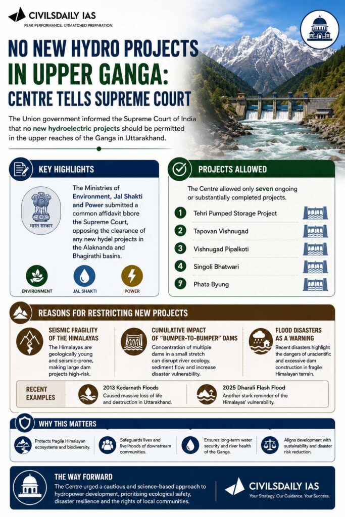
The Union government informed the Supreme Court of India that no new hydroelectric projects should be permitted in the upper reaches of the Ganga in Uttarakhand.
Key Highlights
Ministries of:
Environment
Jal Shakti
Power
Submitted a common affidavit opposing new hydel projects in the Alaknanda and Bhagirathi basins.
Projects Allowed
The Centre allowed only seven ongoing or substantially completed projects, including:
Tehri Pumped Storage Project
Tapovan Vishnugad
Vishnugad Pipalkoti
Singoli Bhatwari
Phata Byung
Reasons for Restricting New Projects
The government cited:
Seismic fragility of the Himalayas
Cumulative impact of “bumper-to-bumper” dams
Flood disasters such as:
2013 Kedarnath floods
2025 Dharali flash flood
Background
The case originated after the 2013 Kedarnath disaster.
The Supreme Court had asked expert committees to study the impact of hydropower projects in Uttarakhand.
[2009] The Dul Hasti Power Station is based on which one of the following rivers?
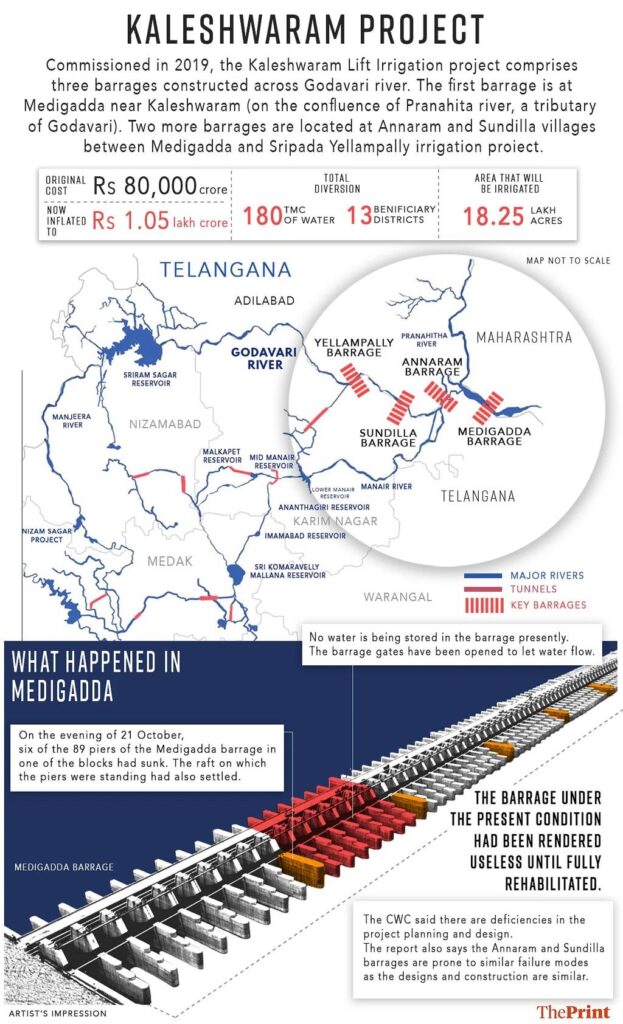
The Telangana High Court ruled that the Ghose Commission report on the Kaleshwaram project will be “inoperative”, and no action can be taken against former CM K. Chandrashekar Rao and others.
Background
The Telangana government constituted a Commission of Inquiry in 2024:
One of the largest lift irrigation projects in India
Built on: Godavari River
Key barrages:
Medigadda
Annaram
Sundilla
[2022] Consider the following pairs: Reservoirs: States 1. Ghataprabha: Telangana 2. Ghandhi Sagar: Madhya Pradesh 3. Indira Sagar: Andhra Pradesh 4. Maithon: Chhattisgarh How many pairs given above ate not correctly matched? [A] Only one pair [B] Only two pair [C] Only three pair [D] All four pair
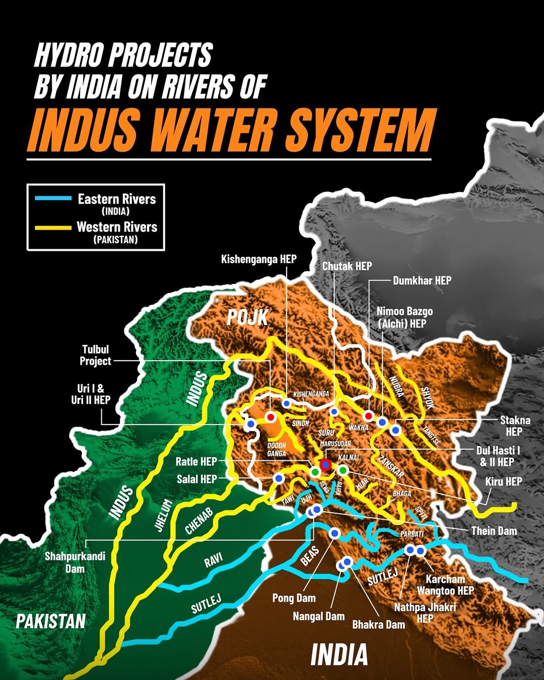
Ratle Hydroelectric Power Corporation Limited has sought an extension of Environmental Clearance (EC) for its 850 MW Ratle Hydroelectric Project on the Chenab River, citing delays due to litigation and COVID-19. The proposal is under appraisal by the Expert Appraisal Committee (EAC) of the Union Environment Ministry.
About the Ratle Hydroelectric Project
Capacity: 850 MW
Location: Kishtwar district, Jammu and Kashmir
River basin: Indus Basin
Type of dam: Concrete gravity dam
Environmental Clearance Timeline
Original EC granted: December 2012
Initial validity: Up to 2022
Extended validity for hydropower projects: Till December 11, 2025
Extension sought due to:
Court litigations between 2014–2021
COVID-19 disruption (April 2020 to March 2021)
Current Legal Issues
Case pending before National Green Tribunal
Allegations of illegal muck dumping into the Chenab
Petition filed by residents of Thathri
Judgment reserved in December 2025
Prelims Pointers
Ratle project is on the Chenab River
Falls under the Indus Basin
EC validity can exclude court stay and COVID periods
Joint venture led by NHPC
Under scrutiny of NGT
[2009] The Dul Hasti Power Station is based on which one of the following rivers?
The Hyderabad Metropolitan Development Authority (HMDA) has announced a new advanced bioremediation initiative using enzyme solutions and biochar-based Bokashi balls to clean and restore Hussainsagar Lake, which has long suffered from algal blooms, foul odour, sewage inflow, and industrial pollution.
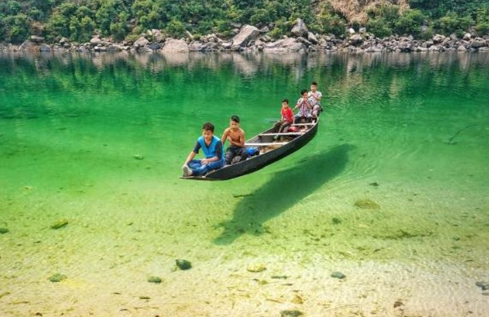
The Umngot River, celebrated for its crystal-clear waters and tourist appeal at Dawki and Shnongpdeng, has turned murky and opaque.
About Umngot River:
Location: Flows through West Jaintia Hills district, Meghalaya, close to the India–Bangladesh border.
Origin: Arises from the Jaintia Hills, traversing limestone-rich terrain that naturally filters impurities and maintains clarity.
Distinct Appearance: Known for its crystal-clear waters that create the illusion of boats floating on air, earning it global recognition.
Length & Course: Flows southward to Dawki town, where it merges with Bangladesh’s Piyain River.
Ecological Features: Possesses high dissolved oxygen levels, preventing algal growth and supporting diverse aquatic biodiversity.
Tourism Hub: Popular at Dawki and Shnongpdeng for boating, fishing, camping, and eco-tourism, drawing thousands of visitors annually.
Infrastructure Landmark: The Dawki Suspension Bridge (1932) is a heritage structure spanning the river and serving as a trade route link.
Economic Role: Sustains cross-border trade, local fishing, and tourism-driven livelihoods vital to Meghalaya’s rural economy.
Cultural Boundary: Serves as a natural divider between Ri Pnar (Jaintia Hills) and Hima Khyrim (Khasi Hills).
Cause of Discoloration:
Primary Cause: Linked to Shillong–Dawki road-widening project upgrading it to a two-lane highway with a 400 m bridge at Dawki.
Pollution Source: Hill-cutting, excavation, and soil dumping along sites near Umtyngar and Dawki caused heavy sediment runoff.
Inspection Findings: The Meghalaya State Pollution Control Board (MSPCB) detected uncontained debris and sliding soil entering the river, reducing water transparency.
The Naying Hydroelectric Project (1000 MW), proposed on the Siyom (Yomgo) River in Shi-Yomi district, Arunachal Pradesh, represents a major addition to India’s clean energy expansion under the Decade of Hydro Power (2025–35).
About Siyom (Yomgo) River:
Geography: A right-bank tributary of the Brahmaputra, flowing entirely within Arunachal Pradesh.
Origin & Course: Arises in West Siang, travels ~170 km, and joins the Brahmaputra near Assam.
Ecology: Basin supports rich biodiversity, agro-pastoral livelihoods, and lies within the Eastern Himalaya Biodiversity Hotspot.
Protected Areas: Mouling National Park lies on its eastern bank, part of the Dibang–Siang biosphere landscape.
Hydrological Role: Ensures irrigation, microclimate regulation, and provides run-of-the-river potential for clean energy, though demanding careful ecosystem balance.
About Naying Hydroelectric Project:
Overview: A proposed 1,000 MW (4×250 MW) run-of-the-river project located in Shi-Yomi district, Arunachal Pradesh.
Developers: Jointly undertaken by North Eastern Electric Power Corporation (NEEPCO) and Arunachal Pradesh Hydropower Corporation Ltd (APHCL).
Design & Output: Features a concrete dam, underground powerhouse, and diversion tunnels, expected to generate 4,966.77 GWh annually.
Regulatory Approval: Received Central Electricity Authority (CEA) concurrence in 2013; progress slowed by environmental and social concerns.
Public Consultation: Environmental hearing scheduled for 12 November 2025 at Yapik Community Hall to assess ecological and community impacts.
Timeline: Construction targeted to start by 2028, with commissioning by 2032.
Policy Context: Forms part of the state’s Decade of Hydro Power (2025–2035), aiming for 19 GW capacity addition to support India’s net-zero goals.
Regional Linkages: Among five key hydel projects in the region – Heo (240 MW), Hirong (500 MW), Tato-I (186 MW), and Tato-II (700 MW).
[UPSC 2022] Consider the following pairs:
Reservoirs – States
1. Ghataprabha — Telangana
2. Gandhi Sagar — Madhya Pradesh
3. Indira Sagar — Andhra Pradesh
4. Maithon —Chhattisgarh
Options:
(a) Only one pair (b) Only two pairs (c) Only three pairs (d) All four pairs”
Karnataka govt. has approved Upper Krishna Project Phase-III to raise Almatti dam height, while Maharashtra warned of moving the Supreme Court against it.
Why is Maharashtra opposing it?
Fears submergence of villages and agricultural land in its territory if water levels rise further.
Worries about reduced water availabilitydownstream, affecting its irrigation and drinking water projects.
About Almatti Dam:
Overview: It is a hydroelectric and irrigation project built on the Krishna River in North Karnataka.
Completion: July 2005, as part of the Upper Krishna Irrigation Project (UKP).
Dimensions: Height 52.5 m, length 3.5 km.
Power Generation: A 290 MW station using vertical Kaplan turbines (five of 55 MW and one of 15 MW).
Two separate powerhouses: Almatti I and II generate power before releasing water into the Narayanpur Reservoir.
Functions: Provides irrigation, potable water, hydroelectric power, and helps in flood management.
Back2Basics: Krishna River
Origin: Near Mahabaleshwar (Satara, Maharashtra), in the Western Ghats.
Length: ~1,300 km, second-longest river in peninsular India after Godavari.
Course: Flows through Maharashtra (303 km), Karnataka (480 km), Telangana, and Andhra Pradesh, before emptying into the Bay of Bengal.
After suspending the Indus Waters Treaty, India is asserting water control in J&K by reviving the Sawalkote Hydroelectric Project — the UT’s largest planned hydro project.
AboutSawalkote Hydro Project:
Location: Ramban and Udhampur districts, Jammu and Kashmir.
River: Built on the Chenab River (a western river under the Indus Waters Treaty).
Agency: Implemented by National Hydroelectric Power Corporation.
History: Proposed in the 1960s; delayed due to Pakistan’s objections, environmental issues, and red tape. Revived after India suspended the Indus Waters Treaty post the April 2025 Pahalgam terror attack.
Status (2025): Forest clearance granted; tenders floated on 29 July 2025; declared a project of national importance.
Timeline: 96 months post-clearance; expected commissioning by or after 2032.
Key Features:
Type: Run-of-the-river (utilizes the natural flow and elevation drop of a river) hydroelectric project.