Mains Ready By December. Smash Mains & Smash PYQ Admissions Open

Category: Ranker Webinars

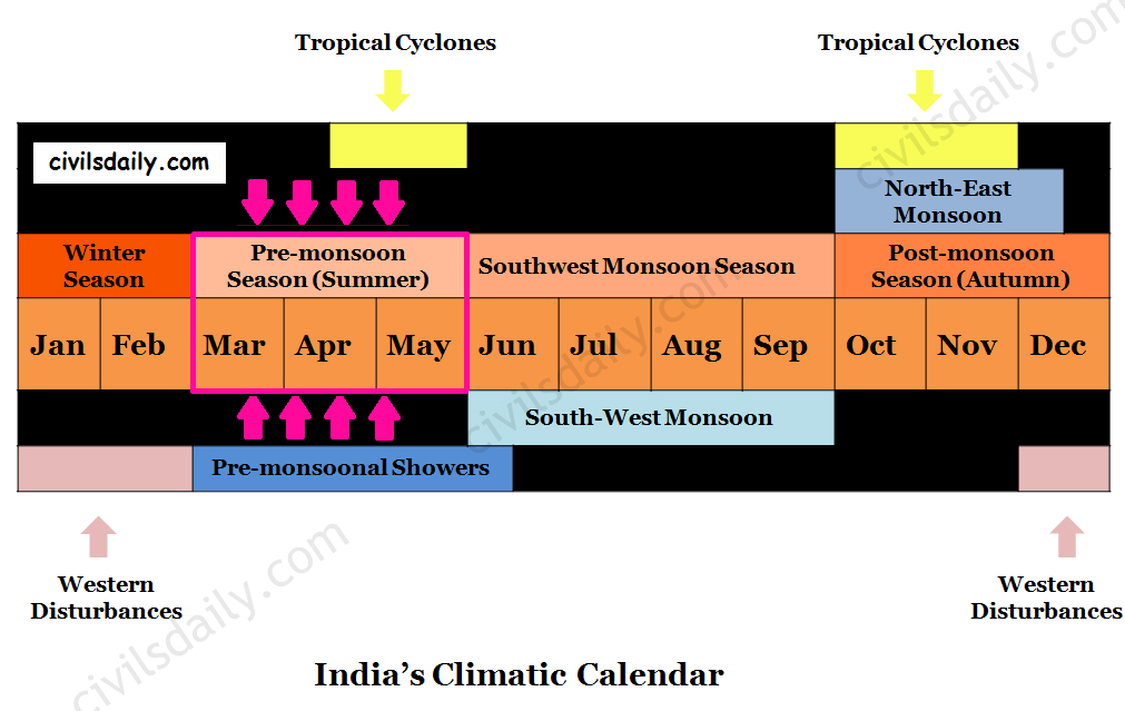
  • The Pre-Monsoon Season/ Summer Season (Mar – May)

    India’s Climatic Calendar – The Summer Season

    Temperature Conditions during this season:

    • As the sun shifts northward towards the Tropic of Cancer after the vernal Equinox, the whole India experiences an increase in temperature.
    • In most parts of India, temperatures recorded are between 30°-32°C.

    North India:

    • April, May and June are the months of summer in north India.
    • In May, the heat belt moves further north, and in the north-western part of India, temperatures around 48°C are not uncommon.

    South India:

    • The Peninsular situation of south India with moderating effect of the oceans keeps the temperatures lower than that prevailing in north India. So, temperatures remain between 26°C and 32°C.
    • Western Ghats – Due to altitude, the temperatures in the hills of Western Ghats remain below 25°C.
    • The temperature increases from the coast towards the interior areas.

    Surface Pressure and Winds:

    • The atmospheric pressure is low all over the country due to high temperatures.
    • Since the sun goes gradually towards the north (summer solstice), the Inter Tropical Convergence Zone (ITCZ) begins to move towards the north (Eventually reaching up to 25° latitude in July).
    • The general direction of winds is from the north-west and west in north-western India, and from the south-west in the Arabian Sea and adjoining coasts.
    • In the months of May and June, the high temperature in north-western India builds steep pressure gradient.
    • Under such conditions, hot dust-laden strong winds known as ‘loo’ blow.
      • These strong dust storms result from the convective phenomenon and their intensity increases in the afternoon. These are locally known as Andhis.
      • These are essentially short-lived thunderstorms, which move like a solid wall of sand and dust.
      • These bring little rainfall and give much needed relief from heat.
      • Dust storms in the evening are very common during May in Punjab, Haryana, Eastern Rajasthan and Uttar Pradesh.
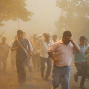
        A Dust Storm in Delhi this May. Image Source

    Pre monsoonal showers:

    • Occasionally, the moisture-laden winds are attracted towards the periphery of the trough. A sudden contact between dry and moist air masses gives rise to local storms of great intensity. These local storms are associated with violent winds, torrential rains and even hailstorms.
    • The thunderstorms which originate over Chotanagpur plateau are carried eastwards by westerly winds. The areas with the highest incidence of thunderstorms are the north-eastern states, West Bengal, and the adjoining areas of Orissa and Jharkhand.
    • In West Bengal and the adjoining areas of Assam, Orissa and Jharkhand, the direction of squalls is mainly from the northwest and they are called Norwesters (Squall – a sudden, violent gusty wind).
      • The rainfall brough by norwesters is called spring storm showers.
      • These are often very violent with squall speeds of 60-80km/hour.
      • Large sized hailstones sometimes accompany these showers and harm the animals and standing crops.
      • The period of maximum occurrence of these storms is the month of Baisakh. These are thus locally called ‘Kal Baisakh (a calamity of the month of Baisakh)’.
      • In Assam, these storms are known as “Bardoli Chheerha or Bordochila”.
    • In the south, thunderstorms occur in Kerala and adjoining parts of Karnataka and Tamil Nadu particularly in the evenings and nights. These pre-monsoonal showers are called by various names:
      • Tea showers in Assam ( they are good for tea, jute and rice)
      • Mango showers in Kerala and coastal areas of Karnataka as they help in the early ripening of mangoes.
      • Cherry Blossoms/ Coffee showers in Kerala and nearby areas (good for coffee plantations)
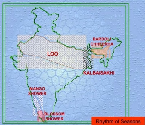
    Image Source

    Tropical Cyclones:

    Tropical Cyclones (TC) are intense low-pressure systems that develop over the seas or oceans in the tropical and subtropical regions. Tropical cyclones cause destruction in the coastal areas because of:

    • High wind velocities.
    • Storm Surge ( i.e. rise of coastal waters due to approaching cyclone)
    • Torrential rainfall which often lead to floods in the coastal areas.

    Note: The interior regions do benefit from the torrential rain associated with a tropical cyclone for agriculture and other applications of water.

    The Indian sub-continent having a coast line of 7516 km is the worst affected region of the world. It is exposed to nearly 10% of the world’s Tropical Cyclones.

    • Many low-pressure systems of varying stages of development form in the Bay of Bengal and in the Arabian Sea and move west or north-westwards, sometimes re-curving north or north-east at a later stage (See the following map ). Re-curvature usually occurs when these systems are between 16° and 18°N.
    • Only a few of them develop fully into the mature stage and the majority remain as depressions.
    • The fully developed low-pressure systems called cyclones generally form in the lower latitude belt (10° N – 14°N) before and after the SW monsoon. They are very intense systems and are responsible for the major portion of rainfall over the peninsula.
    • These systems reach their maximum intensity before/after the monsoon period.
    • During the SW monsoon season, these systems form in the Bay of Bengal and generally travel west or north-west along the monsoon trough. The rainfall over northern India is to a large extent dependent on the frequency, track and intensity of these depressions (called monsoon depressions). The frequency and direction of these cyclones also influence weather conditions along the eastern coast during retreating monsoon season i.e. in October and November.
    • An analysis of the frequencies of cyclones on the East and West coasts of India shows that the East Coast is more prone to tropical cyclones as compared to the West Coast.
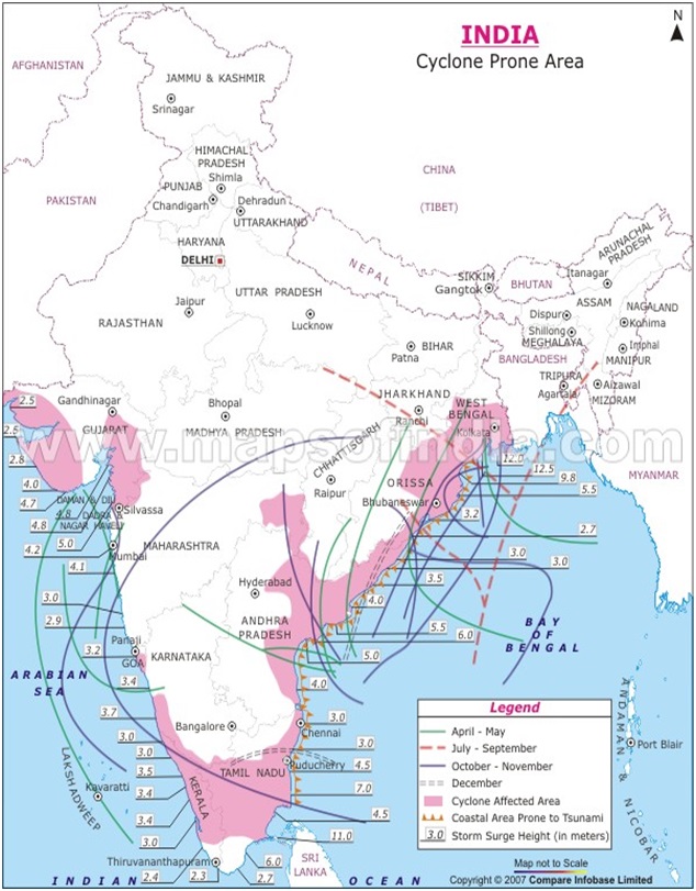
    Image Source

  • Impact of Globalisation on India

    Globalization has been defined as the process of rapid integration of countries and happenings through greater foreign trade and foreign investment. It is the process of international integration arising from the interchange of world views, products, ideas, and other aspects of culture.

    What are the factors aiding globalization?

    FactorDescriptionImpact on IndiaExamples
    TechnologyReduced communication speed drastically, making distance insignificant. Enabled faster access to information and social media.Increased job opportunities requiring analytical, communication, and numerical skills.Growth of IT sector, expansion of social media platforms.
    LPG Reforms (1991)Economic liberalization leading to increased interaction with the global economy.Opened Indian markets to global trade, foreign investment, and competition.Entry of global companies like Ford, Coca-Cola, and Microsoft.
    Faster TransportationImproved transport systems, especially air travel, facilitating easier global movement of people and goods.Enhanced international tourism and trade; facilitated faster export and import processes.Expansion of airports like Delhi and Mumbai for global travel.
    Rise of WTO (1994)Reduced tariffs and non-tariff barriers, promoting free trade agreements between nations.Increased India’s involvement in global trade agreements, fostering economic growth.India’s membership in WTO, trade agreements with other countries.
    Improved Mobility of CapitalGeneral reduction in capital barriers allowing easier flow of capital between economies. Increased interconnectedness of financial markets.Indian companies gained better access to global financial markets, fostering investment in sectors like technology.Indian firms raising capital abroad through IPOs and investments.
    Rise of MNCsMultinational corporations operating in multiple countries lead to the diffusion of best practices and global products.Creation of jobs, transfer of technology, and integration of Indian firms into global value chains.MNCs like Unilever, Amazon, and Tata Group operating globally.

    1) Technology: has reduced the speed of communication manifolds. The phenomenon of social media in the recent world has made distance insignificant.

    The integration of technology in India has transformed jobs that required specialized skills and lacked decision-making skills into extensively defined jobs with higher accountability that require new skills, such as numerical, analytical, communication, and interactive skills. As a result of this, more job opportunities are created for people.

    2) LPG Reforms: The 1991 reforms in India have led to greater economic liberalization which has in turn increased India’s interaction with the rest of the world.

    3) Faster Transportation: Improved transport, making global travel easier. For example, there has been a rapid growth in air-travel, enabling greater movement of people and goods across the globe.

    4) Rise of WTO: The formation of WTO in 1994 led to reduction in tariffs and non-tariff barriers across the world. It also led to the increase in the free trade agreements among various countries.

    5) Improved mobility of capital: In the past few decades there has been a general reduction in capital barriers, making it easier for capital to flow between different economies. This has increased the ability for firms to receive finance. It has also increased the global interconnectedness of global financial markets.

    6) Rise of MNCs: Multinational corporations operating in different geographies have led to a diffusion of best practices. MNCs source resources from around the globe and sell their products in global markets leading to greater local interaction.

    These factors have helped in economic liberalization and globalization and have facilitated the world in becoming a “global village”. Increasing interaction between people of different countries has led to internationalization of food habits, dress habits, lifestyle and views.

    Globalization and India:

    Developed countries have been trying to pursue developing countries to liberalize the trade and allow more flexibility in business policies to provide equal opportunities to multinational firms in their domestic market. International Monetary Fund (IMF) and World Bank helped them in this endeavour. Liberalization began to hold its foot on barren lands of developing countries like India by means of reduction in excise duties on electronic goods in a fixed time frame.

    Indian government did the same and liberalized the trade and investment due to the pressure from World Trade Organization. Import duties were cut down phase-wise to allow MNC’s operate in India on equality basis. As a result globalization has brought to India new technologies, new products and also the economic opportunities.

    Despite bureaucracy, lack of infrastructure, and an ambiguous policy framework that adversely impact MNCs operating in India, MNCs are looking at India in a big way, and are making huge investments to set up R&D centers in the country. India has made a lead over other growing economies for IT, business processing, and R&D investments. There have been both positive and negative impacts of globalization on social and cultural values in India.

    IMPACTS OF GLOBALISATION IN INDIA

    Economic Impact:

    1. Greater Number of Jobs: The advent of foreign companies and growth in economy has led to job creation. However, these jobs are concentrated more in the services sector and this has led to rapid growth of service sector creating problems for individuals with low level of education. The last decade came to be known for its jobless growth as job creation was not proportionate to the level of economic growth.
    2. More choice to consumers: Globalisation has led to a boom in consumer products market. We have a range of choice in selecting goods unlike the times where there were just a couple of manufacturers.
    3. Higher Disposable Incomes: People in cities working in high paying jobs have greater income to spend on lifestyle goods. There has been an increase in the demand of products like meat, egg, pulses, organic food as a result. It has also led to protein inflation.

    Protein food inflation contributes a large part to the food inflation in India. It is evident from the rising prices of pulses and animal proteins in the form of eggs, milk and meat.

    With an improvement in standard of living and rising income level, the food habits of people change. People tend toward taking more protein intensive foods. This shift in dietary pattern, along with rising population results in an overwhelming demand for protein rich food, which the supply side could not meet. Thus resulting in a demand supply mismatch thereby, causing inflation.

    In India, the Green Revolution and other technological advancements have primarily focused on enhancing cereals productivity and pulses and oilseeds have traditionally been neglected.

    • Shrinking Agricultural Sector: Agriculture now contributes only about 15% to GDP. The international norms imposed by WTO and other multilateral organizations have reduced government support to agriculture. Greater integration of global commodities markets leads to constant fluctuation in prices.
    • This has increased the vulnerability of Indian farmers. Farmers are also increasingly dependent on seeds and fertilizers sold by the MNCs.
    • Globalization does not have any positive impact on agriculture. On the contrary, it has few detrimental effects as government is always willing to import food grains, sugar etc. Whenever there is a price increase of these commodities.
    • Government never thinks to pay more to farmers so that they produce more food grains but resorts to imports. On the other hand, subsidies are declining so cost of production is increasing. Even farms producing fertilizers have to suffer due to imports. There are also threats like introduction of GM crops, herbicide resistant crops etc.
    • Increasing Health-Care costs: Greater interconnections of the world has also led to the increasing susceptibility to diseases. Whether it is the bird-flu virus or Ebola, the diseases have taken a global turn, spreading far and wide. This results in greater investment in healthcare system to fight such diseases.
    • Child Labour: Despite prohibition of child labor by the Indian constitution, over 60 to a 115 million children in India work. While most rural child workers are agricultural laborers, urban children work in manufacturing, processing, servicing and repairs. Globalization most directly exploits an estimated 300,000 Indian children who work in India’s hand-knotted carpet industry, which exports over $300 million worth of goods a year.

    Socio-Cultural Impact on Indian Society

    Nuclear families are emerging. Divorce rates are rising day by day. Men and women are gaining equal right to education, to earn, and to speak. ‘Hi’, ‘Hello’ is used to greet people in spite of Namaskar and Namaste. American festivals like Valentines’ day, Friendship day etc. are spreading across India.

    • Access to education: On one hand globalisation has aided in the explosion of information on the web that has helped in greater awareness among people. It has also led to greater need for specialisation and promotion of higher education in the country.
    • On the flip side the advent of private education, coaching classes and paid study material has created a gap between the haves and have-nots. It has become increasingly difficult for an individual to obtain higher education.
    • Growth of cities: It has been estimated that by 2050 more than 50% of India’s population will live in cities. The boom of services sector and city centric job creation has led to increasing rural to urban migration.
    • Indian cuisine: is one of the most popular cuisines across the globe. Historically, Indian spices and herbs were one of the most sought after trade commodities. Pizzas, burgers, Chinese foods and other Western foods have become quite popular.
    • Clothing: Traditional Indian clothes for women are the saris, suits, etc. and for men, traditional clothes are the dhoti, kurta. Hindu married women also adorned the red bindi and sindhur, but now, it is no more a compulsion. Rather, Indo-western clothing, the fusion of Western and Sub continental fashion is in trend. Wearing jeans, t-shirts, mini skirts have become common among Indian girls.
    • Indian Performing Arts: The music of India includes multiples varieties of religious, folk, popular, pop, and classical music. India’s classical music includes two distinct styles: Carnatic and Hindustani music. It remains instrumental to the religious inspiration, cultural expression and pure entertainment. Indian dance too has diverse folk and classical forms.
    • Bharatanatyam, Kathak, Kathakali, Mohiniattam, Kuchipudi, Odissi are popular dance forms in India. Kalarippayattu or Kalari for short is considered one of the world’s oldest martial art. There have been many great practitioners of Indian Martial Arts including Bodhidharma who supposedly brought Indian martial arts to China.
    • The Indian Classical music has gained worldwide recognition but recently, western music is too becoming very popular in our country. Fusing Indian music along with western music is encouraged among musicians. More Indian dance shows are held globally. The number of foreigners who are eager to learn Bharatanatyam is rising. Western dance forms such as Jazz, Hip hop, Salsa, Ballet have become common among Indian youngsters.
    • Nuclear Families: The increasing migration coupled with financial independence has led to the breaking of joint families into nuclear ones. The western influence of individualism has led to an aspirational generation of youth. Concepts of national identity, family, job and tradition are changing rapidly and significantly.
    • Old Age Vulnerability: The rise of nuclear families has reduced the social security that the joint family provided. This has led to greater economic, health and emotional vulnerability of old age individuals.
    • Pervasive Media: There is greater access to news, music, movies, videos from around the world. Foreign media houses have increased their presence in India. India is part of the global launch of Hollywood movies which is very well received here. It has a psychological, social and cultural influence on our society.
    • McDonaldization: A term denoting the increasing rationalization of the routine tasks of everyday life. It becomes manifested when a culture adopts the characteristics of a fast-food restaurant. McDonaldization is a reconceptualization of rationalization, or moving from traditional to rational modes of thought, and scientific management.
    • Walmartization: A term referring to profound transformations in regional and global economies through the sheer size, influence, and power of the big-box department store WalMart. It can be seen with the rise of big businesses which have nearly killed the small traditional businesses in our society.

    Psychological Impact on Indian Society

    AspectDescriptionImpact on Indian SocietyExamples
    Development of Bicultural IdentityA hybrid identity combining local cultural roots with a global awareness. Young individuals are now able to connect with both local and global cultures.Educated youth may embrace global practices in their professional lives while adhering to traditional Indian values at home.Preference for arranged marriages, while being tech-savvy and global.
    Growth of Self-Selected CulturePeople forming groups to maintain their identities separate from global culture, seeking to protect values that global culture may undermine.Some individuals resist global consumerism and individualism, preferring local traditions and values.Rural communities focusing on preserving local traditions.
    Emerging AdulthoodDelay in taking on adult roles like work,  marriage, and parenthood due to extended education and job preparation in the technological economy.Youth are now taking more time to marry or start a family, focusing instead on career and education.Young Indians opting for higher education and career before marriage.
    ConsumerismA shift towards Western consumerist culture, particularly in urban areas, with increased consumption of goods and services influenced by the media.Traditional dress and lifestyle patterns are being replaced by Western fashion and consumer habits.Urban Indians adopting Western clothing and lifestyle brands.
    Globalization’s PaceIncreased interaction between people worldwide due to technology and economic structures.Greater exposure to global events, ideas, and values through media and the internet.The rise of internet use and social media for global communication.
    • Development of Bicultural Identity: The first is the development of a bicultural identity or perhaps a hybrid identity, which means that part of one’s identity is rooted in the local culture while another part stems from an awareness of one’s relation to the global world.
    • The development of global identities is no longer just a part of immigrants and ethnic minorities. People today especially the young develop an identity that gives them a sense of belonging to a worldwide culture, which includes an awareness of events, practices, styles and information that are a part of the global culture. Media such as television and especially the Internet, which allows for instant communication with any place in the world, play an important part in developing a global identity.

    A good example of bicultural identity is among the educated youth in India who despite being integrated into the global fast paced technological world, may continue to have deep rooted traditional Indian values with respect to their personal lives and choices such as preference for an arranged marriage, caring for parents in their old age.

    1. Growth of Self-Selected Culture: means people choose to form groups with like-minded persons who wish to have an identity that is untainted by the global culture and its values. The values of the global culture, which are based on individualism, free market economics, and democracy and include freedom, of choice, individual rights, openness to change, and tolerance of differences are part of western values. For most people worldwide, what the global culture has to offer is appealing. One of the most vehement criticisms of globalization is that it threatens to create one homogeneous worldwide culture in which all children grow up wanting to be like the latest pop music star, eat Big Macs, vacation at Disney World, and wear blue jeans, and Nikes.
    2. Emerging Adulthood: The timing of transitions to adult roles such as work, marriage and parenthood are occurring at later stages in most parts of the world as the need for preparing for jobs in an economy that is highly technological and information based is slowly extending from the late teens to the mid-twenties. Additionally, as the traditional hierarchies of authority weaken and break down under the pressure of globalization, the youth are forced to develop control over their own lives including marriage and parenthood. The spread of emerging adulthood is related to issues of identity.
    3. Consumerism: Consumerism has permeated and changed the fabric of contemporary Indian society. Western fashions are coming to India: the traditional Indian dress is increasingly being displaced by western dresses especially in urban areas. Media- movies and serials- set a stage for patterns of behavior, dress codes and jargon. There is a changing need to consume more and more of everything.

    Globalisation is an age old phenomenon which has been taking place for centuries now. We can experience it so profoundly these days because of its increased pace. The penetration of technology and new economic structures are leading to an increased interaction between people. As with other things there have been both positive and negative impacts on India due to it.

    Conclusion:

    We cannot say that the impact of globalization has been totally positive or totally negative. It has been both. Each impact mentioned above can be seen as both positive as well as negative. However, it becomes a point of concern when, an overwhelming impact of globalization can be observed on the Indian culture.

    Every educated Indian seems to believe that nothing in India, past or present, is to be approved unless recognized and recommended by an appropriate authority in the West. There is an all-pervading presence of a positive, if not worshipful, attitude towards everything in western society and culture, past as well as present in the name of progress, reason and science. Nothing from the West is to be rejected unless it has first been weighed and found wanting by a Western evaluation. This should be checked, to preserve the rich culture and diversity of India.

  • Civilsdaily Listicles & Titbits | High Yield Material for Quick Prelims Revision

    When done with basic book reading and Prelims is near, many aspirants face the dilemma of how to revise entire syllabus and then remember important points from it.

    We understood this problem and our team worked together to compile all important topics at one place through excel sheets and Dr V compiled all important static syllabus points through Titbits.

    The excel sheets prepared by us are available to view and download below (best viewed on desktop/ large screens):

    1. Important Acts/bills- Bills/Acts/Amendments which have been in news from 2014-2017- Click2view
    2. Declarations, conventions, protocols- Contains important IR pacts signed in the last few years- Click2view
    3. Important Books/ Texts in Indian History – IAS Pre & beyond- Click2view
    4. Satellites, Space Missions, Space Tech by India –Click2view
    5. Important Historical Sculptures- Click2view
    6. Important Temples/Monasteries/Stupa/Caves- Click2view
    7. Key/important Terms related to Ancient/ Medieval History- contains nearly 180 terms from the most authentic history textbooks of our times Click2view
    8. Tribes in India, their festivals, and culture- Click2view


    Read all Titbits here

    1. Polity Titbits: Fundamentals of Polity and Constitution Click2read
    2. Polity Titbits: Important articles/schedules of Constitution Click2read
    3. Polity Titbits: Functions/powers of legislature Click2read
    4. Polity Titbits: Functions/powers of executive Click2read
    5. Polity Titbits: Functions/powers of Judiciary Click2read
    6. Polity Titbits: Constitution- Special provisions Click2read
    7. Polity Titbits: Constitutional, Statutory and quasi-judicial bodies Click2read
    8. Polity Titbits: Panchayati Raj- Local governance Click2read


  • The Islands

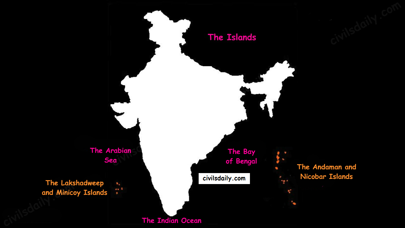
    There are two major island groups in India

    • The island groups of Bay of Bengal: Andaman & Nicobar Islands
    • The island groups of Arabian Sea: Lakshadweep and Minicoy Islands
    The Physiographic Divisions of India | The Islands

    Let’s take these up one by one:

    Andaman & Nicobar Islands:

    • Also called the emerald islands.
    • Location and Extent:
      • These are situated roughly between 6°N-14°N and 92°E -94°E.
      • The most visible feature of the alignment of these islands is their narrow longitudinal extent.
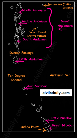
      • These islands extend from the Landfall Island in the north (in the Andamans) to the Indira Point (formerly known as Pygmalion Point and Parsons Point) in the south (In the Great Nicobar).
    • Origin: The Andaman and Nicobar islands have a geological affinity with the tertiary formation of the Himalayas, and form a part of its southern loop continuing southward from the Arakan Yoma.
    • The entire group of islands is divided into two broad categories:
      • The Andaman in the north, and
      • The Nicobar in the south.

    They are separated by a water body which is called the Ten degree channel.

    • The Andaman islands are further divided into:
      • Great Andamans
        • North Andaman
        • Middle Andaman
        • South Andaman
      • Little Andaman

    Little Andaman is separated from the Great Andamans by the Duncan Passage.

    The Andaman and Nicobar Islands
    • Chief Characteristics:
      • These are actually a continuation of Arakan Yoma mountain range of Myanmar and are therefore characterized by hill ranges and valleys along with the development of some coral islands.
      • Some smaller islands are volcanic in origin e.g. the Barren island and the Narcondam Island. Narcondam is supposed to be a dormant volcano but Barren perhaps is still active.
      • These islands make an arcuate curve, convex to the west.
      • These islands are formed of granitic rocks.
      • The coastal line has some coral deposits, and beautiful beaches.
      • These islands receive convectional rainfall and have an equatorial type of vegetation.
      • These islands have a warm tropical climate all year round with two monsoons.
      • The Saddle peak (North Andaman – 738 m) is the highest peak of these islands.
      • The Great Nicobar is the largest island in the Nicobar group and is the southernmost island. It is just 147 km away from the Sumatra island of Indonesia.

    Lakshadweep Islands:

    • These islands were earlier (before 1st November 1973) known as Laccadive, Minicoy and Amindivi Islands.
    • Location:
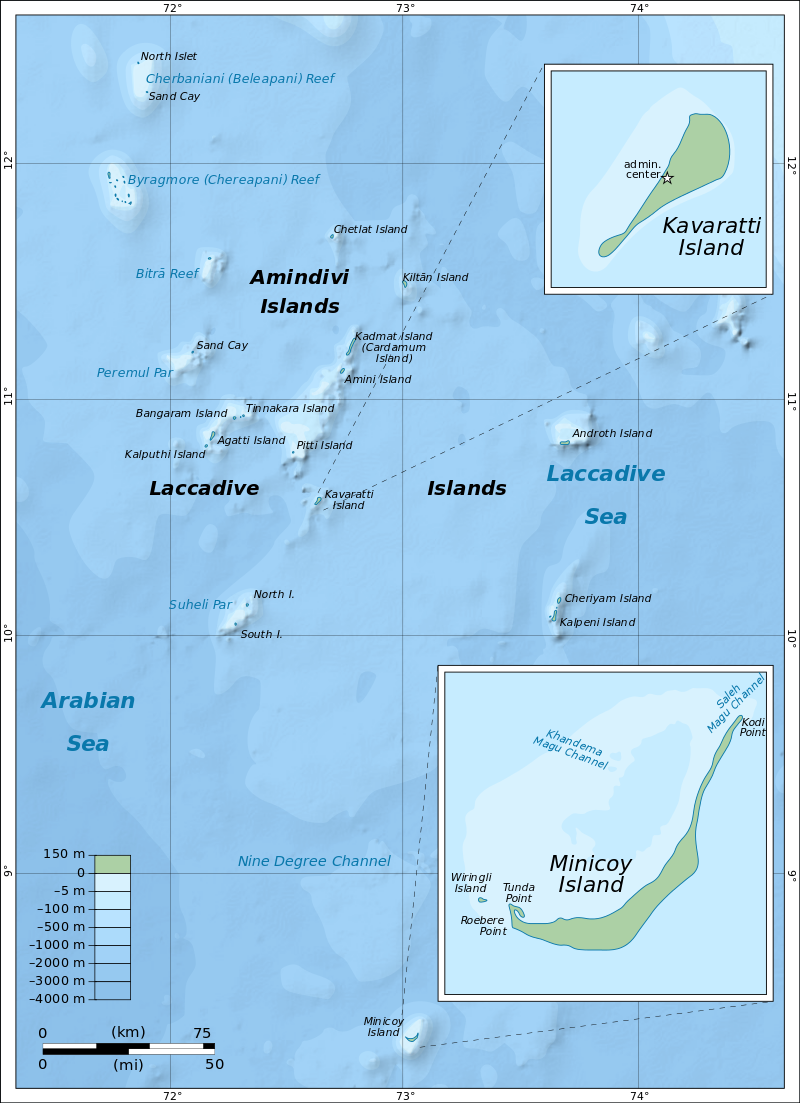
      • These are scattered in the Arabian Sea between 8°N-12°N and 71°E -74°E longitude.
      • These islands are located at a distance of 280 km-480 km off the Kerala coast.
    • Origin: The entire island group is built of coral deposits.
    • Important islands:
      • Amindivi and Cannanore islands in the north.
      • Minicoy (lies to the south of the nine degree channel) is the largest island with an area of 453 sq. km.

    map_of_lakshadweep-en-svg

    Source

    • Chief Characteristics:
      • These consist of approximately 36 islands of which 11 are inhabited.
      • These islands, in general, have a north-south orientation (only Androth has an East-West orientation.
      • These islands are never more that 5 metres above sea level.
      • These islands have calcium rich soils- organic limestones and a scattered vegetation of palm species.
      • One typical feature of these islands is the formation of crescentic reef in the east and a lagoon in the west.
      • Their eastern seaboard is steeper.
      • The Islands of this archipelago have storm beaches consisting of unconsolidated pebbles, shingles, cobbles and boulders on the eastern seaboard.
      • The islands form the smallest Union Territory of India.

    Other than the above mentioned two major groups, the important islands are:

    • Majauli: in Assam. It is:
      • The world’s largest freshwater (Brahmaputra river) island.
      • India’s first island district
    • Salsette: India’s most populous island. Mumbai city is located on this island.
    • Sriharikota: A barrier island. On this island is located the satellite launching station of ISRO.
    • Aliabet: India’s first off-shore oil well site (Gujarat); about 45 km from Bhavnagar, it is in the Gulf of Khambat.
    • New Moore Island: in the Ganga delta. It is also known as Purbasha island. It is an island in the Sunderban deltaic region and it was a bone of contention between India and Bangladesh. In 2010, it was reported to have been completely submerged by the rising sea water due to Global warming.
    • Pamban Island: lies between India and Sri Lanka.
    • Abdul Kalam Island: The Wheeler Island near the Odisha coast was renamed as Abdul Kalam island in 2015. It is a missile launching station in the Bay of Bengal. The first successful land-to-land test of the Prithvi Missile was conducted from the mainland and it landed on the then uninhabited ‘Wheeler Island’ on November 30, 1993.

    Now that we are done with this part, let’s try to attempt some questions from the past UPSC examinations:

    Prelims:

    1996

    Question: ‘Saddle Peak’ the highest peak of Andaman and Nicobar islands is located in

    A. Great Nicobar

    B. Middle Andaman

    C. Little Andaman

    D. North Andaman

    Ans. D

    Mains:

    Question: Write a short note on New Moore Island. (2006/2M)

    Question: Write a short note on Indira Point. (2007/2M)

    Question: Name the main physiographic divisions of India and give the salient features of each division. (2000/15M).

    Question: How do the Andaman and Nicobar Islands and the Lakshadweep differ in the geological evolution and topographical conditions? (1998/15M)

  • The Indian Desert

    The Indian desert is also known as the Thar Desert or the Great Indian Desert.

    Location and Extent:

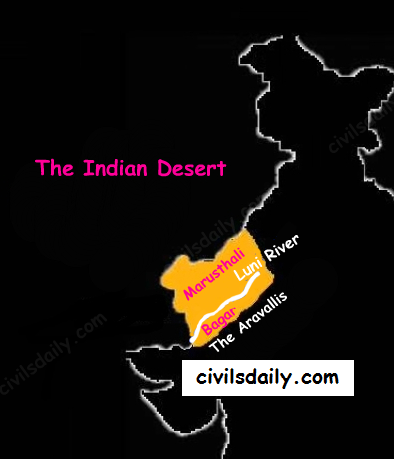
    • Location – To the north-west of the Aravali hills.
    • It covers Western Rajasthan and extends to the adjacent parts of Pakistan.
    The Physiographic Divisions of India | The Indian Desert

    Geological History and Features

    • Most of the arid plain was under the sea from Permo-Carboniferous period and later it was uplifted during the Pleistocene age. This can be corroborated by the evidence available at wood fossils park at Aakal and marine deposits around Brahmsar, near Jaisalmer (The approximate age of the wood fossils is estimated to be 180 million years).
    • The presence of dry beds of rivers (eg Saraswati) indicates that the region was once fertile.
    • Geologically, the desert area is a part of peninsular plateau region but on the surface it looks like an aggradational plain.

    Chief Characteristics:

    • The desert proper is called the Marusthali (dead land) as this region has an arid climate with low vegetation cover. In general, the Eastern part of the Marushthali is rocky, while its western part is covered by shifting sand dunes.
    • Bagar: Bagar refers to the semi-desert area which is west of Aravallis. Bagar has a thin layer of sand. It is drained by Luni in the south whereas the northern section has a number of salt lakes.
    • The Rajasthan Bagar region has a number of short seasonal streams which originate from the Aravallis. These streams support agriculture in some fertile patches called Rohi.
    • Even the most important river ‘Luni’ is a seasonal stream. The Luni originates in the Pushkar valley of the Aravalli Range, near Ajmer and flows towards the southwest into the Rann of Kutch.
    • The region north of Luni is known as the Thali or sandy plain.
    • There are some streams which disappear after flowing for some distance and present a typical case of inland drainage by joining a lake or playa e.g. the Sambhar Lake. The lakes and the playas have brackish water which is the main source of obtaining salt.
    • Well pronounced desert land features:
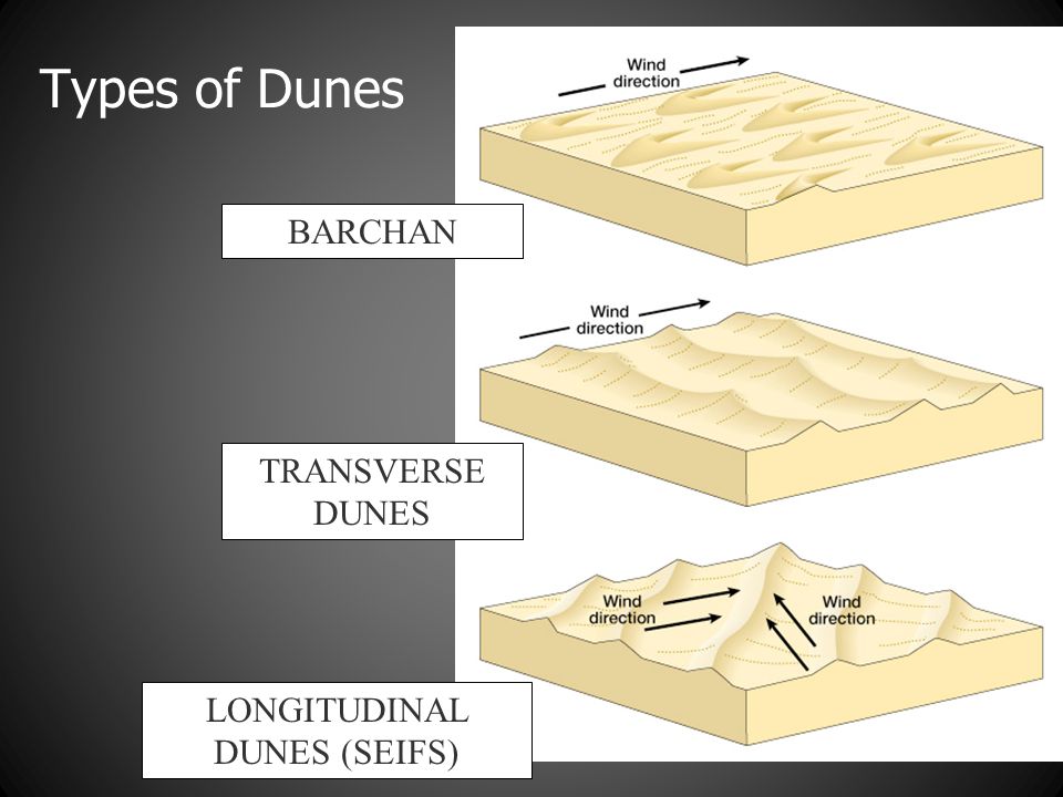
      • Sand dunes: It is a land of undulating topography dotted with longitudinal dunes, transverse dunes and barchans. [Barchan – A crescent-shaped sand dune, the horns of which point away from the direction of the dominant wind; Longitudinal dune – A sand dune with its crest running parallel to the direction of prevailing wind]

    sand-dunes

    Image Source

    • Mushroom rocks
    • Shifting dunes (locally called Dhrians)
    • Oasis (mostly in its southern part)
  • The Coastal Plains

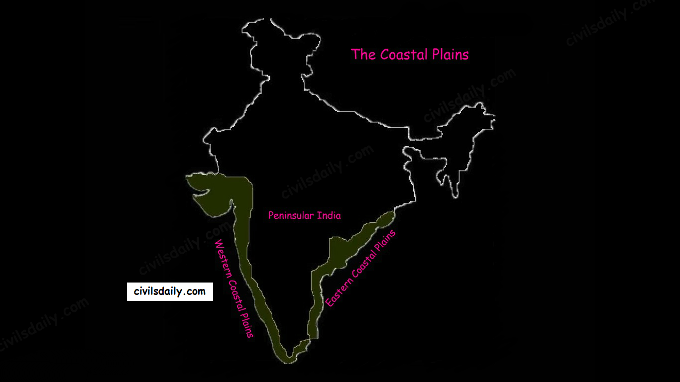
    Of the total coastline of India (7517 km), that of the peninsula is 6100 km between the peninsular plateau and the sea. The peninsular plateau of India is flanked by narrow coastal plains of varied width from north to south.

    The Physiographic Divisions of India | The Coastal Plains

    On the basis of the location and active geomorphologic processes, these can be broadly divided into two parts:

    • The western coastal plains
    • The eastern coastal plains.

    We now take them up one by one:

    The Western Coastal Plain

    1. Extent: The Western Coastal Plains are a thin strip of coastal plains with a width of 50 kms between the Arabian Sea and the Western Ghats.

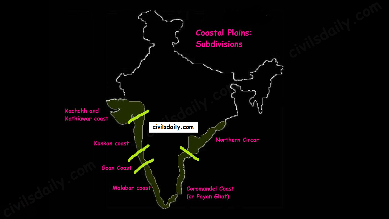
    2. Subdivisions: Extending from the Gujarat coast in the north to the Kerala coast in the south, the western coast may be divided into following divisions:

    • Kachchh and Kathiawar coast in Gujarat,
    • Konkan coast in Maharashtra,
    • Goan Coast in Karnataka, and
    • Malabar coast in Kerala

    Note: Kutch and Kathiawar, though an extension of Peninsular plateau (because Kathiawar is made of the Deccan Lava and there are tertiary rocks in the Kutch area), they are still treated as an integral part of the Western Coastal Plains as they are now levelled down.

    Subdivisions of the eastern and Western Coastal Plains

    3. A coastline of submergence: The western coastal plains are an example of submerged coastal plain. It is believed that the city of Dwaraka which was once a part of the Indian mainland situated along the west coast is submerged under water.

    4. Characteristic Features:

    • The western coastal plains are narrow in the middle and get broader towards north and south. Except for the Kachchh and Kathiawar coastal region, these are narrower than their eastern counterpart.
    • The coast is straight and affected by the South-West Monsoon winds over a period of six months. The western coastal plains are thus wetter than their eastern counterpart.
    • The western coast being more indented than the eastern coast provides natural conditions for the development of ports and harbours. Kandla, Mazagaon, JLN port Navha Sheva, Marmagao, Mangalore, Cochin, etc. are some of the important natural ports located along the west coast.
    • The western coastal plains are dotted with a large number of coves (a very small bay), creeks (a narrow, sheltered waterway such as an inlet in a shoreline or channel in a marsh) and a few estuaries. The estuaries, of the Narmada and the Tapi are the major ones.
    • The rivers flowing through this coastal plain do not form any delta. Many small rivers descend from the Western Ghats making a chain of waterfalls.
    • The Kayals – The Malabar coast has a distinguishing feature in the form of ‘Kayals’ (backwaters). These backwaters are the shallow lagoons or the inlets of the sea and lie parallel to the coastline. These are used for fishing, inland navigation and are important tourist spots. The largest of these lagoons is the Vembanad lake. Kochi is situated on its opening into the sea.

    The Eastern Coastal Plain

    1. Extent: The Eastern Coastal Plains is a strip of coastal plain with a width of 100 – 130 kms between the Bay of Bengal and the Eastern Ghats

    2. Subdivisions: It can be divided into two parts:

    • Northern Circar: The northern part between Mahanadi and Krishna rivers. Additionally, the coastal tract of Odisha is called the Utkal plains.
    • Coromandel Coast (or Payan Ghat): The southern part between Krishna and Kaveri rivers.

    3. A coastline of emergence: The eastern coastal plain is broader and is an example of an emergent coast.

    4. Characteristic features:

    • The eastern coastal plains are wider and drier resulting in shifting sand dunes on its plains.
    • There are well-developed deltas here, formed by the rivers flowing eastward in to the Bay of Bengal. These include the deltas of the Mahanadi, the Godavari, the Krishna and the Kaveri.
    • Because of its emergent nature, it has less number of ports and harbours. The continental shelf extends up to 500 km into the sea, which makes it difficult for the development of good ports and harbours.
    • Chilika lake is an important feature along the eastern coast. It is the largest salt water lake in India.

    Significance of the Coastal Plains region:

    • These plains are agriculturally very productive. The western coast grows specialized tropical crops while eastern coasts witnessed a green revolution in rice.
    • The delta regions of eastern coastal plains have a good network of canals across the river tributaries.
    • Coastal plains are a source of salt, monazite (used for nuclear power) and mineral oil and gas as well as centres of fisheries.
    • Although lacking in adequate natural harbours, with a number of major and minor ports, coastal plains are centres of commerce and have attracted dense human settlements.
    • The coastal regions of India are noted for tourist centres, fishing and salt making.

    Now that we are done with this part, let’s try to attempt some questions from the past UPSC examinations:

    Prelims:

    Question: Assertion (A): The eastern coast of India produces more rice than the western coast.

    Reason (R): The eastern coast receives more rainfall than the western coast.

    Ans. C (Assertion is right but reason is wrong)

    Mains:

    Question: Assess the significance of coastal regions in the economic development of India. (2009/ 15 marks)

  • Drainage System | Part 6

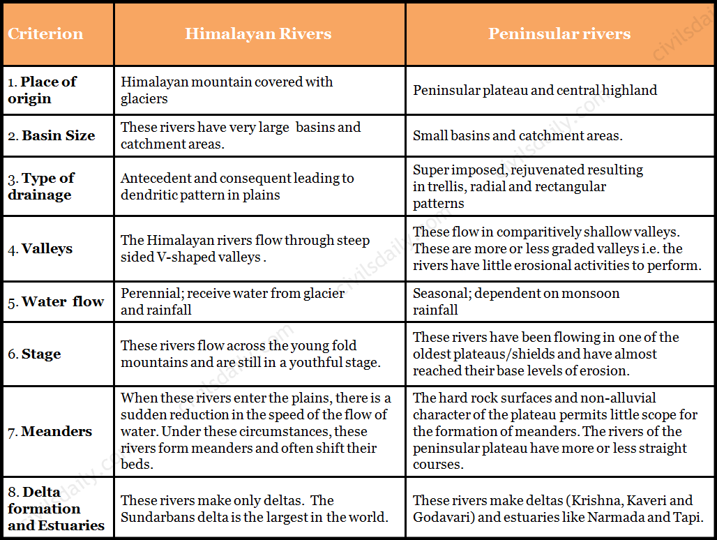
    In the previous posts, we studied the Himalayan and Peninsular river systems in detail. Before we move further, let’s list the key differences between them:

    Key Differences between the Himalayan and Peninsular Rivers

    The Shifting Courses of Rivers:

    An interesting phenomenon observed in the case of most of the peninsular and extra-peninsular rivers is that they have shifting courses, especially in their lower reaches. In the upper reaches, the Himalayan rivers have the tendencies of river capturing.

    Wondering why a river shifts its course? There can be numerous reasons as to why a river shifts its course. It could be a response to physiographic changes or it could be a part of its natural evolution e.g. fast-flowing rivers are prone to silting up as they surge down the hills and spread out on the plains, allowing sand and suspended matter to deposit in their slower, wider depths. Over time, the deposits create resistance, forcing the river to move to an area of lower resistance. This leads to a shift in its course.

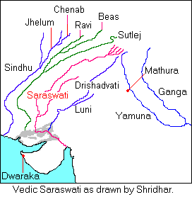
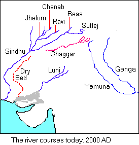
    The ancient Saraswati river, which provided an abode for the early Aryan settlers presents a typical example of shifting courses and river capturing. Descending from the Himalayan ranges, its initial course during the prehistoric period was passing near Churu (about 2000 to 3000 BC) and the Luni river was one of its tributaries.

    Source

    It gradually shifted towards west till it joined the Satluj near Ahmadpur. Later on, the water of its upper course was captured by a tributary of the Ganga river, as a result of which, its lower course became dry. This gave birth to the Yamuna river, an important tributary of the Ganga river system. Even today, the dry valley of the Saraswati river is found in the Rajasthan area in the form of Ghaggar valley.

    Source

    Similar shifting has also been observed in the rivers of Punjab during historical past. The records of 3rd century BC show that the Indus flowed more than 130 km east of its present course, through the now practically dry beds of the deserted channel, to the Rann of Kachchh which was then a gulf of the Arabian Sea. Later on it gradually shifted west and occupied its present position.

    Even the entry of Brahmaputra into the plains of Assam is an outcome of the process of river capturing. According to geologists, during early days, the Tsangpo river of Tibet taking an easterly course used to join the Irrawaddy river (Myanmar) through the Chindwin, which was then a large river, transporting huge quantity of water. Later on, a small river flowing along the southern slopes of the Himalayas through its headward erosion captured the water of the Tsangpo river, and thus helped in the evolution of the stream of Brahmaputra.

    Kosi and Gandak are notorious for changing their courses during floods.

    With this, we conclude our discussion on the Indian Drainage system. Let’s now try to attempt some related questions from the past UPSC examinations:

    Prelims

    (1997)

    Question: The Alamatti is on the river:

    A. Godavari

    B. Cauveri

    C. Krishna

    D. Mahanadi

    Ans. C

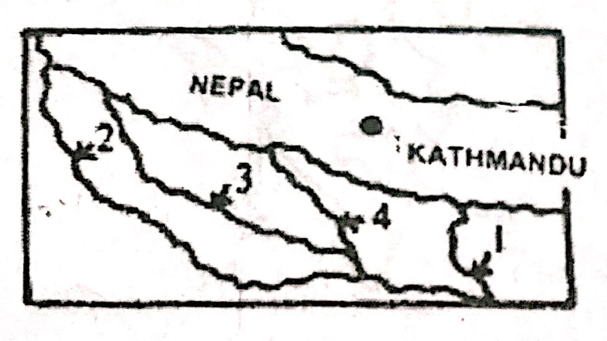
    Question: In the map shown in the given figure, river labelled as 1,2,3 and 4 respectively:

    A. Kosi, Gomati, Ghaghara and Gandak

    B. Kosi, Ganga, Gomati and Ghaghara

    C. Gandak, Ganga, Gomati and Ghaghara

    D. Teesta, Gomati, Ghaghara and Kosi

    Ans. A

    (1998)

    Question: Which of the following east-flowing rivers of India has rift valley due to down warping?

    A. Damodar

    B. Mahanadi

    C. Son

    D. Yamuna

    Ans. A

    (2000)

    Question: Which one of the following statements is not true?

    A. Ghaggar’s water is utilised in the Indira Gandhi canal

    B. Narmada rises from the Amarkantak region

    C. Nizam Sagar is situated on the Manjira river

    D. Penganga is a tributary of the Godavari.

    Ans. A

    (2002)

    Question: The correct sequence of the eastward flowing rivers of the Peninsular India from north to south is

    A. Subarnarekha, Mahanadi, Godavari, Krishna, Pennar, Cauvery and Vaigai

    B. Subarnarekha, Mahanadi, Krishna, Godavari, Cauvery, Vaigai, and Pennar

    C. Mahanadi, Subarnarekha, Godavari, Krishna, Cauvery, Pennar and Vaigai

    D. Mahanadi, Subarnarekha, Krishna, Godavari, Cauveri, Vaigai and Pennar

    Ans. A

    (2003)

    Question: What is the correct sequence of the rivers – Godavari, Mahanadi, Narmada and Tapi in the descending order of their lengths?

    A. Godavari – Mahanadi – Narmada – Tapi

    B. Godavari – Narmada – Mahanadi – Tapi

    C. Narmada – Godavari – Tapi – Mahanadi

    D. Narmada – Tapi – Godavari – Mahanadi

    Ans. B

    (2006)

    Question: Which one of the following statements is not correct?

    A. Mahanadi river rises in Chattisgarh.

    B. Godavari river rises in Maharashtra.

    C. Cauvery river rises in Andhra Pradesh.

    D. Tapti River rises in Madhya Pradesh.

    Ans. C

    Question: Between which of the following was the ancient town of Takshasila located?

    A. Indus and Jhelum.

    B. Jhelum and Chenab.

    C. Chenab and Ravi.

    D. Ravi and Beas.

    Ans. A

    Question: From north towards south, which one of the following is the correct sequence of the given rivers in India?

    A. Shyok – Spiti – Zaskar – Satluj

    B. Shyok – Zaskar – Spiti – Satluj

    C. Zaskar – Shyok – Satluj – Spiti

    D. Zaskar – Satluj – Shyok – Spiti

    Ans. B

    (2007)

    Question: Match List-I with List-II and select the correct answer using the code given below the lists:

    List-I List-II

    A. Betul 1. Indravati

    B. Jagdalpur 2. Narmada

    C. Jabalpur 3. Shipra

    D. Ujjain 4. Tapti

    A) A1 B4 C2 D3

    B) A4 B1 C2 D3

    C) A4 B1 C3 D2

    D) A1 B4 C3 D2

    Ans. B

    Question: Which of the following rivers originates at Amarkantak?

    A. Damodar

    B. Mahanadi

    C. Narmada

    D. Tapti

    Ans. C

    Question: Assertion (A): River Kalinadi is an east-flowing river in the southern part of India.

    Reason (R): The Deccan plateau is higher along its western edge and gently slopes towards the Bay of Bengal in the east.

    Ans. D (A is false but R is true)

    Mains:

    Question: There is no formation of deltas by rivers of the Western Ghat. Why? (2013/10 marks)

    Question: What are the causes for dominant dendritic pattern of drainage in the Gangetic plains? (2010/5M)

    Question: Why do the rivers of west coast not form a delta? (2006/2M)

    Question: Describe the major characteristics of rivers of peninsular India. (2003/10M)

    Question: Write a short note on two prominent left bank tributaries of river Ganges. (2001/2M)

    Question: Why do the rivers of the peninsular India have well defined rigid channels in sharp contrast to the Himalayan rivers? (1995/2M)

    Question: Name the major international rivers flowing through India. What countries/States are covered by the Ganga and Godavari rivers on their course from their source to the sea? (1980/2M)

  • Drainage System | Part 5

    The Peninsular Drainage:

    The Peninsular drainage system is older than the Himalayan one. This is evident from the broad, largely-graded shallow valleys, and the maturity of the rivers.

    Evolution:

    Three major geological events in the distant past have shaped the present drainage systems of Peninsular India:

    • Subsidence of the western flank of the Peninsula leading to its submergence below the sea during the early tertiary period. Generally, it has disturbed the symmetrical plan of the river on either side of the original watershed and left just the upper parts of west flowing rivers above the sea level.
    • Upheaval of the Himalayas when the northern flank of the Peninsular block was subjected to subsidence and the consequent trough faulting. The Narmada and The Tapi flow in trough faults and fill the original cracks with their detritus materials. Hence, there is a lack of alluvial and deltaic deposits in these rivers.
    • Slight tilting of the Peninsular block from north-west to the southeastern direction gave orientation to the entire drainage system towards the Bay of Bengal during the same period.

    River-Systems:

    The peninsular river system can be categorised into the following sections:

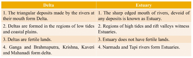
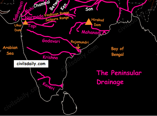
    • The East flowing rivers – the Mahanadi, the Godavari, the Krishna and the Cauvery flow eastwards and drain into the Bay of Bengal. These rivers make deltas at their mouths.
    • The West flowing rivers:
      • Narmada and Tapi along with other small rivers originating from the Western Ghats and falling in the Arabian Sea form estuaries in place of deltas. This is due to the fact that these rivers, especially Narmada and Tapi, flow through hard rocks and are not able to form distributaries before they enter the sea.
      • Although these west flowing rivers of Sahyadri form only about 3% of the areal extent of basins of India, they contain about 18% of the country’s water resources.

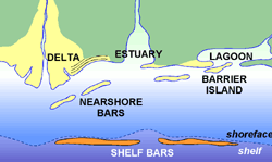
    Wondering what is the difference between a delta and an estuary? Let’s see:

    Source

    Source

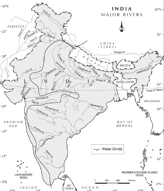
    • The Western Ghats running close to the western coast act as a water divide between the major Peninsular Rivers discharging their water in the Bay of Bengal and the small rivulets joining the Arabian Sea.
    • The Chambal, the Sind, the Betwa, the Ken, the Son, originating in the northern part of the Peninsula belong to the Ganga river system.
    • The Peninsular rivers are characterized by fixed courses, absence of meanders and non-perennial flow of water. The Narmada and the Tapi which flow through the rift valley are, however, exceptions.
    The Peninsular Drainage

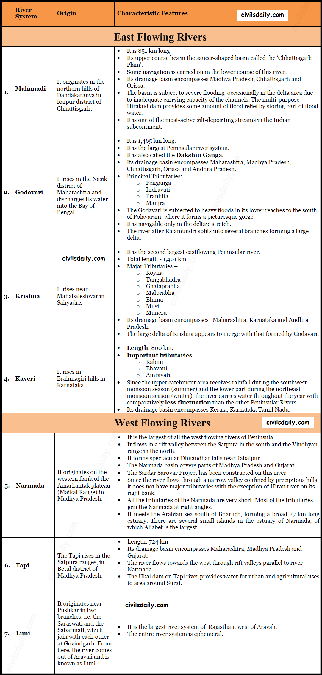
    A brief account of the major Peninsular river systems is given below:

    Major Peninsular River Systems

    Smaller rivers flowing Towards the West:

    The rivers flowing towards the Arabian Sea have short courses ( Because their origins lie closer to the sea, and the Western Ghats act as a water divide). Several of these small rivers are important for the production of hydroelectricity because of steep slopes and waterfalls.

    Gujarat:

    • The Shetruniji – It rises near Dalkahwa in Amreli district.
    • The Bhadra – It originates near Aniali village in Rajkot district.
    • The Dhadhar rises near Ghantar village in Panchmahal district.
    • Sabarmati
    • Mahi

    Maharashtra:

    • The Vaitarna rises from the Trimbak hills in Nasik district
    • The Kalinadi rises from Belgaum district and falls in the Karwar Bay.
    • The source of Bedti river lies in Hubli Dharwar and traverses a course of 161 km.
    • The Sharavati is another important river in Karnataka flowing towards the west. The Sharavati originates in Shimoga district of Karnataka and drains a catchment area of 2,209 sq. km. The famous Jog or Gersoppa Falls (289m) made by Sharavati river are the highest untiered waterfalls in India.

    Goa:

    • Mandovi
    • Juari

    Kerala:

    • Bharathapuzha – It is the largest river of Kerala. It is also known as Ponnani. It originates from Annamalai hills and flows into the Arabian Sea at a place called Ponnani.
    • The Periyar – It is the longest and the second largest river of Kerala. [Largeness of a river is related to its basin size and the volume of water flowing in the river. At the same time when we say that a river is the longest, it means that we are referring to its geographical length]
    • The Pamba river – It falls in the Vembanad lake.

    Small Rivers Flowing towards the East:

    There are small rivers which join the Bay of Bengal, though small, these are important in their own right.

    • The Subarnrekha
    • the Baitarni
    • the Brahmani
    • the Vamsadhara
    • the Penner
    • the Palar
    • the Vaigai
  • Drainage System | Part 4

    The Ganga River System

    • The Ganga river system is the largest in India having a number of perennial and non-perennial rivers originating in the Himalayas in the north and the Peninsula in the south, respectively. It accounts for 26.3% of the geographical area of the country and is shared by ten states.
    • Ambala is located on the water divide between Indus and Ganga.
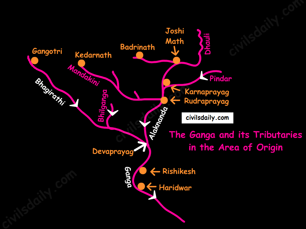
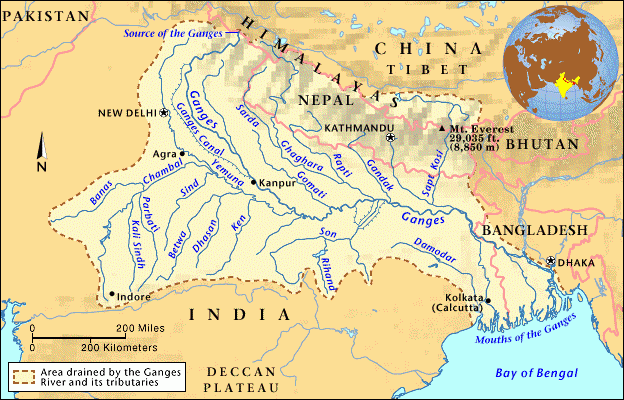
    • Origin: It rises in the Gangotri glacier near Gaumukh in the Uttarkashi district of Uttaranchal. Here, it is known as the Bhagirathi. At Devprayag, the Bhagirathi meets the Alaknanda; hereafter, it is known as the Ganga.
    The Ganga and its Tributaries in the Area of Origin
    • The river-course:
      • The Ganga enters the plains at Haridwar.
      • From here, it flows first to the south, then to the south-east direction to reach Allahabad. Here it is joined by the Yamuna.
      • Further, near Rajmahal hills, Ganga turns south-east and bifurcates at Farakka into Bhagirathi – Hugli in West Bengal and as the Padma in Bangladesh.
      • The river finally discharges itself into the Bay of Bengal near the Sagar Island.

    Source

    • Important left bank tributaries of the Ganga:
      • Ramganga
      • Gomati
      • Ghaghara
      • Gandak
      • Kosi
      • Mahananda
    • Important right bank tributaries of the Ganga:
      • Son
      • Yamuna

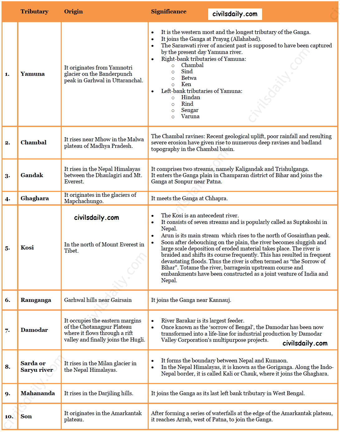
    Some important tributaries and their characteristic features:

    Important Tributaries of Ganga and their Characteristic Features

    The Brahmaputra River System:

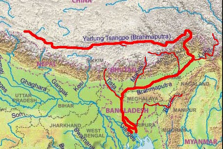
    Source

    • Origin: The Brahmaputra has its origin in the Chemayungdung glacier of the Kailash range near the Mansarovar lake. Mariam La separates the source of the Brahmaputra from the Manasarovar Lake.
    • The river-course:
      • Most of the course of the Brahmaputra lies in Tibet, popularly known as Tsangpo. It flows eastwards parallel to the Himalayas. It receives a large number of tributaries in Tibet. The first major tributary is the Raga Tsangpo meeting the Tsangpo near Lhatse Dzong.
      • After reaching Namcha Barwa, it takes a “U” turn (also known as Hair Pin turn) and enters India west of Sadiya town in Arunachal Pradesh through the deep Dihang or Siang gorge of Himalayas. Here initially it is called as Siang and then as Dihang.
      • It is joined by Dibang, Lohit, Kenula and many other tributaries and finally forms the Brahmaputra in Assam.
      • It then enters into Bangladesh near Dhubri and flows southward. In Bangladesh, the Tista joins it on its right bank from where the river is known as the Jamuna. [Note: The Tista was a tributary of the Ganga prior to the floods of 1787 after which it diverted its course eastwards to join the Brahmaputra.]
      • The Jamuna and Ganga confluence at Goalundo and afterwards are called as the Padma. Further south, Padma is joined by Meghna (Barak river in India) and thence onward it is known as Meghna to finally merge in the Bay of Bengal.
    • It is called:
      • The Tsangpo in Tibet ( Tsangpo = ‘the purifier.’)
      • The Brahmaputra in India
      • The Jamuna in Bangladesh
    • Major left bank tributaries:
      • Burhi Dihing,
      • Dhansari (South)
      • Kalang
    • Major right bank tributaries:
      • Subansiri ( It has its origin in Tibet and is an antecedent river.)
      • Kameng
      • Manas
      • Sankosh
    • Characteristic Features:
      • River Brahmaputra is a little longer than the river Indus.
      • It forms a spectacular Grand Canyon – like canyon in Tibet.
      • The river is nearly 16 km wide at Dibrugarh and forms many islands, the most important of which is Majuli. Majuli is the world’s largest riverine island and India’s first island district.
      • The Brahmaputra has a braided channel. It carries a lot of silt and there is excessive meandering.
      • The Brahmaputra is well-known for floods, channel shifting and bank erosion. This is due to the fact that most of its tributaries are large, and bring large quantity of sediments owing to heavy rainfall in its catchment area.
  • Drainage System | Part 3

    The Indian Drainage System

    The Indian drainage system consists of a large number of small and big rivers.

    It is an outcome of:

    • The evolutionary process of the three major physiographic units
    • The nature and characteristics of precipitation.
    Source

    Classification of Drainage Systems in India:

    1. On the basis of discharge of water – the Arabian Sea drainage and the Bay of Bengal drainage:

    On the basis of discharge of water (orientations to the sea), the drainage system of India may be grouped into:

    • the Arabian Sea drainage
    • the Bay of Bengal drainage

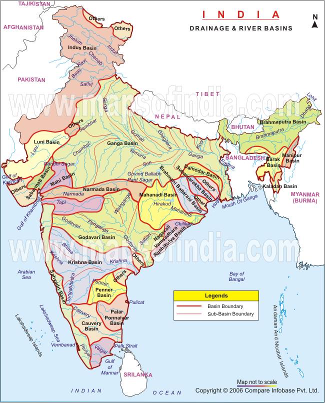
    They are separated from each other by the Delhi ridge, the Aravalis and the Sahyadris (water divide is shown by a line in the following map).

    Source: NCERT

    Nearly 77 percent of the drainage area consisting of the Ganga, the Brahmaputra, the Mahanadi, the Krishna, etc. is oriented towards the Bay of Bengal while 23 percent comprising the Indus, the Narmada, the Tapi, the Mahi and the Periyar systems discharge their waters in the Arabian Sea.

    1. Rivers of the inland drainage basin (endorheic basin): When a river does not reach the sea but disappears into the sand, such a region is called an area of inland drainage. Inland drainage streams are ephemeral streams (short-lived). E.g.:

    • The Ghaggar river in Haryana, which is supposed to be remnant of the proverbial ancient Saraswati river, gets lost in dry sands near Hanumangarh in Rajasthan.
    • The Luni river in Rajasthan originates near Ajmer and after flowing through Thar desert gets lost in the Rann of Kutch.
    • The Aksai Chin region in Ladakh too has some inland drainage.

    2. On the basis of the size of the watershed:

    • Major river basins – with more than 20,000 sq. km of catchment area. It includes 14 drainage basins such as the Ganga, the Brahmaputra, the Krishna, the Tapi, the Narmada, the Mahi, the Pennar, the Sabarmati, the Barak, etc.
    • Medium river basins – with catchment area between 2,000-20,000 sq. km incorporating 44 river basins such as the Kalindi, the Periyar, the Meghna, etc.
    • Minor river basins – with catchment area of less than 2,000 sq. Km, these include 55 river basins.

    3. On the basis of the mode of origin, nature and characteristics:

    • The Himalayan drainage, and
    • The Peninsular drainage.

    There is no clear-cut line of demarcation between these two drainage systems, as many of the peninsular rivers like the Chambal, Betwa, Sind, Ken and Son are much older in age and origin than the Himalayan rivers.

    Let’s follow this line of classification and look at the drainage system of India in detail. We begin with the Himalayan drainage.

    The Himalayan Drainage system:

    • It consists of the rivers originating in the Himalayan and trans-Himalayan region. It further consists of three river systems namely:
      • the Ganga,
      • the Indus, and
      • the Brahmaputra river systems.
    • Since these are fed both by the melting of snow and precipitation, rivers of this system are perennial.
    • The various geographical features made by the Himalayan rivers are:
      • In upper reaches (Youthful stage): Gorges, V-shaped valleys, rapids, waterfalls, truncated spurs etc.
      • In plain areas or middle part (Mature stage): While entering the plains, they form depositional features like flat valleys, ox-bow lakes, flood plains, braided channels, and deltas near the river mouth. Over the plains, they display a strong meandering tendency and shift their courses frequently.

    Evolution of the Himalayan Drainage System:

    There is a difference of opinion about the evolution of the Himalayan Rivers. However, geologists believe that:

    1. A mighty river called Shiwalik or Indo-Brahma traversed the entire longitudinal extent of the Himalaya from Assam to Punjab and onwards to Sind, and finally discharged into the Gulf of Sind near lower Punjab during the Miocene period some 5-24 million years ago.

    Evidences: The remarkable continuity of the Shiwalik and its lacustrine origin and alluvial deposits consisting of sands, silt, clay, boulders and conglomerates support this viewpoint.

    1. It is opined that in due course of time Indo–Brahma river was dismembered into three main drainage systems:
    • the Indus and its five tributaries in the western part;
    • the Ganga and its Himalayan tributaries in the central part; and
    • the stretch of the Brahmaputra in Assam and its Himalayan tributaries in the eastern part.

    The dismemberment was probably due to the Pleistocene upheaval in the western Himalayas, including the uplift of the Potwar Plateau (Delhi Ridge), which acted as the water divide between the Indus and Ganga drainage systems.

    Likewise, the downthrusting of the Malda gap area between the Rajmahal hills and the Meghalaya plateau during the mid-pleistocene period, diverted the Ganga and the Brahmaputra systems to flow towards the Bay of Bengal.

    Let’s take up the three major river systems of the Himalayan drainage individually:

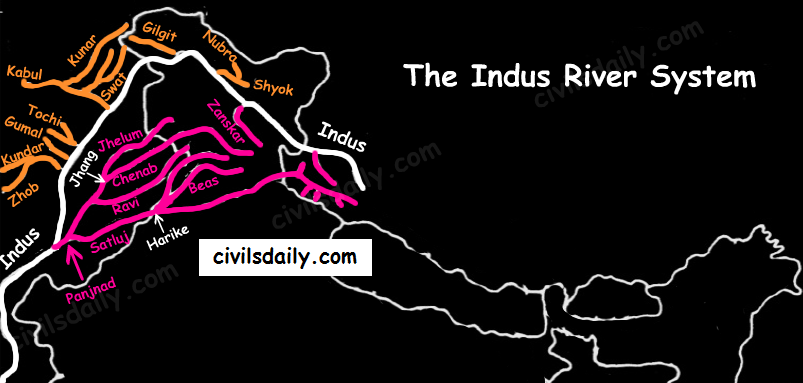
    1. The Indus River System

    • It is one of the largest river basins of the world. A little over one-third of the Indus basin is located in India; in the states of Jammu & Kashmir, Himachal Pradesh and Punjab. The rest of the portion is in Pakistan.
    • The Indus also known as the Sindhu, is the westernmost of the Himalayan rivers in India.
    • Origin: It originates from a glacier near Bokhar Chu in the Kailash Mountain range (Tibetan region). In Tibet, it is known as ‘Singi Khamban; or Lion’s mouth.
    • The river-course:
      • The Indus cuts through Himalayas and enters India near Damchok.
      • flows in India only through the Leh district in Jammu and Kashmir.
      • It enters into Pakistan near Chillar in the Dardistan region through a deep gorge near the hair-pin bend of Nanga Parbat.
      • It finally discharges into the Arabian Sea, east of Karachi.
    • The right-bank tributaries of Indus:
      • Shyok
      • Gilgit
      • Hunza
      • Nubra
      • Kabul
      • Khurram
      • Tochi
      • Gomal
      • Sangar
      • Kunar
    • The left-bank tributaries of Indus:
      • Zaskar
      • ‘Panjnad’ joins Indus a little above Mithankot). The Panjnad is the name given to the five rivers of Punjab, namely:
        • Satluj
        • Beas
        • Ravi
        • Chenab
        • Jhelum
      • Chief Characteristics:
        • The Indus drains the largest number of glaciers of Himalayas, Ladakh, Zaskar, and Kailash.
        • The Indus plain has a very gentle slope.
    Indus and its Tributaries

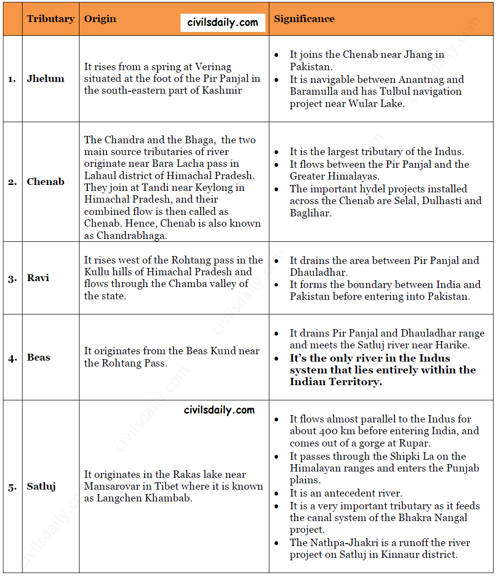
    Let’s look at some important tributaries of Indus:

    Important Tributaries of Indus and their Characteristic Features

    The Indus water treaty:

    The waters of the Indus river system are shared by India and Pakistan according to the Indus Water Treaty signed between the two countries on 19th September 1960. According to this treaty, India can utilise only 20 percent of its total discharge of water. The Indus water treaty was recently in news. Remember why? Read here!