💥Join UPSC 2027,2028 Mentorship (July Batch) + XFactor Notes & Microthemes PDF

GS Paper: GS1-14.Important Geophysical phenomena such as earthquakes, Tsunami, Volcanic activity, cyclone etc.,

  • Odisha’s Mo Bus: Recipient of the UN’s prestigious public service award

    Mo Bus, the bus service of Odisha’s Capital Region Urban Transport (CRUT) authority, has been recognized by the United Nations as one of 10 global recipients of its annual Public Service Awards for 2022.

    Mo Bus service

    • The Mo Bus service was launched on November 6, 2018.
    • It aimed to ensure transformation of the urban public transport scenario in the city and its hinterland through use of smart technology, service benchmarking and customer satisfaction.
    • The buses are designed to integrate smart technologies such as free on-board Wi-Fi service, digital announcements, surveillance cameras, and electronic ticketing.
    • CRUT says that to increase women’s participation in the workforce, and to make women riders feel safer, it is committed to ensuring that 50% of Mo Bus Guides (conductors) are women.

    What is the recent award?

    • The public transport service has been recognised for its role in “promoting gender-responsive public services to achieve the SDGs (Sustainable Development Goals)”.
    • The “impact” is that 57 per cent of the city’s commuters now use the Mo Bus, the UN said.
    • Mo E-Ride is estimated to reduce pollution by 30-50 per cent.

    About UN Public Service Award

    • The UN describes its Public Service Awards as the “most prestigious international recognition of excellence in public service”.
    • The first Awards ceremony was held in 2003, and the UN has since received “an increasing number of submissions from all around the world”.
    • It is intended to reward the creative achievements and contributions of public service institutions that lead to a more effective and responsive public administration in countries worldwide.
    • Through an annual competition, the UN Public Service Awards promotes the role, professionalism and visibility of public service.


    UPSC 2023 countdown has begun! Get your personal guidance plan now! (Click here)
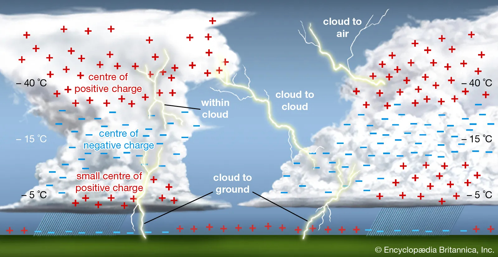
  • Explained: Occurrence of Lightning

    At least 70 people died in lightning strikes across Uttar Pradesh, Madhya Pradesh and Rajasthan.

    What is lightning?

    • Scientifically, lightning is a rapid and massive discharge of electricity in the atmosphere some of which is directed towards earth.
    • The discharges are generated in giant moisture-bearing clouds that are 10-12 km tall.
    • The base of these clouds typically lie within 1-2 km of the Earth’s surface, while the top is 12-13 km away.
    • Temperatures in the top of these clouds are in the range of –35° to –45°C.

    Its formation

    • As water vapour moves upward in the cloud, the falling temperature causes it to condense.
    • As they move to temperatures below 0°C, the water droplets change into small ice crystals.
    • They continue to move up, gathering mass until they are so heavy that they start to fall to Earth.
    • This leads to a system in which, simultaneously, smaller ice crystals are moving up and bigger crystals are coming down.
    • Collisions follow and trigger the release of electrons, a process that is very similar to the generation of sparks of electricity.
    • As the moving free electrons cause more collisions and more electrons, a chain reaction ensues.
    • This process results in a situation in which the top layer of the cloud gets positively charged, while the middle layer is negatively charged.
    • The electrical potential difference between the two layers is huge, of the order of a billion to 10 billion volts.
    • In very little time, a massive current, of the order of 100,000 to a million amperes, starts to flow between the layers.

    Types of lightning

    • Broadly, there are three forms of lightning:
    1. Inter-cloud
    2. Intra-cloud
    3. Cloud-to-ground
    • It is the cloud-to-ground form of lightning that kills humans, as well as animals and livestock, and can substantially damage property.
    • While the Earth is a good conductor of electricity, it is electrically neutral.
    • However, in comparison to the middle layer of the cloud, it becomes positively charged.
    • As a result, about 15%-20% of the current gets directed towards the Earth as well.
    • It is this flow of current that results in damage to life and property on Earth.

    How intensely does it strike?

    • A typical lightning flash is about 300 million volts and 30,000 amps.
    • To put it in perspective, household current is 120 volts and 15 amps.
    • A flash of lightning is enough to light a 100-watt incandescent bulb for about three months.

    Why does lightning kill so many people in India?

    • The reason for the high number of deaths is due to people being caught unawares and more than 70% of fatalities happened due to people standing under isolated tall trees.
    • About 25 per cent of the people were struck in the open.
    • Also, lightning is the direct promulgation of climate change extremities.

    Mitigating lightning incidents

    • Lightning is not classified as a natural disaster in India.
    • But recent efforts have resulted in the setting up of an early warning system that is already saving many lives.
    • More than 96% of lightning deaths happen in rural areas.
    • As such, most of the mitigation and public awareness programmes need to focus on these communities.
    • Lightning protection devices are fairly unsophisticated and low-cost. Yet, their deployment in the rural areas, as of now, is extremely low.
    • States are being encouraged to prepare and implement lightning action plans, on the lines of heat action plans.
    • An international centre for excellence on lightning research to boost detection and early warning systems is also in the process of being set up.


    UPSC 2023 countdown has begun! Get your personal guidance plan now! (Click here)

  • How Marine Heatwave fuelled super cyclone Amphan

    The super-cyclone Amphan is said to have been triggered by Marine Heatwaves.

    What is the news?

    • A study has found the presence of a strong MHW beneath the track of the cyclone with an extremely high anomalous sea surface temperature of more than 2.5°C.
    • This coincided with the cyclone track and facilitated its rapid intensification in a short period.

    What are Marine Heatwaves?

    • We know that heatwaves occur in the atmosphere. We are all familiar with these extended periods of excessively hot weather.
    • However, heatwaves can also occur in the ocean and these are known as marine heatwaves, or MHWs.
    • These marine heatwaves, when ocean temperatures are extremely warm for an extended period of time can have significant impacts on marine ecosystems and industries.

    When do they occur?

    • Heatwaves can happen in summer and also in winter, where they are known as “winter warm-spells”.
    • These winter events can have important impacts, such as in the southeast of Australia where the spiny sea urchin can only colonize further south when winter temperatures are above 12 °C.

    What causes marine heatwaves?

    • Marine heatwaves can be caused by a whole range of factors, and not all factors are important for each event.
    • The most common drivers of marine heatwaves include ocean currents which can build up areas of warm water and air-sea heat flux, or warming through the ocean surface from the atmosphere.
    • Winds can enhance or suppress the warming in a marine heatwave, and climate modes like El Niño can change the likelihood of events occurring in certain regions.
    • MHWs can be caused due to large-scale drivers of the Earth’s climate like the El Niño Southern Oscillation (ENSO).

    Impacts of the MHWs

    • Marine heatwaves affect ecosystem structure, by supporting certain species and suppressing others.
    • For example, after the 2011 marine heatwave in Western Australia, the fish communities had a much more “tropical” nature than previously and switched from kelp forests to seaweed turfs.
    • Marine heatwaves can cause economic losses through impacts on fisheries and aquaculture.
    • Temperature-sensitive species such as corals are especially vulnerable to MHWs. In 2016, marine heatwaves across northern Australia led to severe bleaching of the Great Barrier Reef.

    How do we measure marine heatwaves?

    • A marine heatwave occurs when seawater temperatures exceed a seasonally-varying threshold (usually the 90th percentile) for at least 5 consecutive days.
    • Successive heatwaves with gaps of 2 days or less are considered part of the same event.

    Why study MHWs?

    • MHWs are increasing in frequency due to climate change. MHWs increased by 54 per cent in the last 30 years.
    • MHW has severe socio-economic consequences such as fish mortality, and coral bleaching, and also has the potential to interact and modify other extreme events such as tropical cyclones.

    Way Forward

    • Marine heatwaves clearly have the potential to devastate marine ecosystems and cause economic losses in fisheries, aquaculture, and ecotourism industries.
    • However, their effects are often hidden from view under the waves until it is too late.
    • By raising general awareness of these phenomena, and by improving our scientific understanding of their physical properties and ecological impacts, we can better predict future conditions and protect vulnerable marine habitats and resources.


    UPSC 2023 countdown has begun! Get your personal guidance plan now! (Click here)

  • Theri Desert in Tamil Nadu

    Most of us may not know the small desert situated in the state of Tamil Nadu. It consists of red sand dunes and is confined to the Thoothukudi district.

    Theri Desert

    • The red dunes are called theri in Tamil.
    • They consist of sediments dating back to the Quaternary Period and are made of marine deposits.
    • They have very low water and nutrient retention capacity.
    • The dunes are susceptible to aerodynamic lift.
    • This is the push that lets something move up. It is the force that is the opposite of weight.

    Mineral composition of Theris

    • The analysis of the red sand dunes reveal the presence of heavy and light minerals.
    • These include Ilmenite, Magnetit, Rutile, Garnet, Zircon, Diopside, Tourmaline, Hematite, Goethite, Kyanite, Quartz, Feldspar, Biotite.
    • The iron-rich heavy minerals like ilmenite, magnetite, garnet, hypersthene and rutile present in the soil had undergone leaching by surface water.
    • They were then oxidised because of the favourable semi-arid climatic conditions.

    How did they form?

    • Theris appear as gentle, undulating terrain.
    • The lithology of the area shows that the area might have been a paleo (ancient) coast in the past.
    • The presence of limestone in many places indicates marine transgression.
    • The present-day theris might have been formed by the confinement of beach sand locally, after regression of the sea.
    • When high velocity winds from the Western Ghats blew east, they induced migration of sand grains and accumulation of dunes.

    Another story of their formation

    • Another view is that these are geological formations that appeared in a period of a few hundred years.
    • The red sand is brought from the surface of a broad belt of red loam in the plains of the Nanguneri region (about 57 kilometres) by south west monsoon winds during May-September.
    • The winds after draining the moisture behind the Mahendragiri hill and the Aralvaimozhi gap of the Western Ghats become dry and strike the plains in the foothills, where vegetation is sparse.
    • Deforestation and the absence of vegetative cover in the Aralvaimozhi gap and the Nanguneri plains are considered to be the major causes of wind erosion.


    UPSC 2023 countdown has begun! Get your personal guidance plan now! (Click here)

  • Microplastics found in Antarctica

    Scientists have found microplastics — plastic pieces much smaller than a grain of rice — in freshly fallen Antarctic snow for the first time.

    What are Microplastics?

    • Microplastics are tiny bits of various types of plastic found in the environment.
    • The name is used to differentiate them from “macroplastics” such as bottles and bags made of plastic.
    • There is no universal agreement on the size of microplastics. It defines microplastic as less than 5mm in length.
    • However, for the purposes of this study, since the authors were interested in measuring the quantities of plastic that can cross the membranes and diffuse into the body via the bloodstream.
    • Hence they agreed on an upper limit on the size of the particles as 0.0007 millimetre.

    Why in news?

    • Researchers have found microplastics in the snow samples from the Ross Ice Shelf in Antarctica.

    Threats posed by Microplastics

    • Microplastics has the potential to influence the climate by accelerating melting of ice.
    • They limit growth, reproduction, and general biological functions in organisms, as well as humans.


    Try this PYQ:

    1. Why is there a great concern about the ‘microbeads’ that are released into environment?

    (a) They are considered harmful to marine ecosystems.

    (b) They are considered to cause skin cancer in children.

    (c) They are small enough to be absorbed by crop plants in irrigated fields.

    (d) They are often found to be used as food adulterants.

    Post your answers here.[wpdiscuz-feedback id=”l00nal2to1″ question=”Please leave a feedback on this” opened=”1″][/wpdiscuz-feedback]


    Back2Basics: Ross Ice Shelf

    • Ross Ice Shelf is the largest ice shelf of Antarctica roughly the size of France.
    • It is several hundred metres thick.
    • The nearly vertical ice front to the open sea is more than 600 kilometres long, and between 15 and 50 metres (50 and 160 ft) high above the water surface.
    • Ninety percent of the floating ice, however, is below the water surface.
    • Most of Ross Ice Shelf is in the Ross Dependency claimed by New Zealand.
    • It floats in, and covers, a large southern portion of the Ross Sea and the entire Roosevelt Island located in the east of the Ross Sea.


    UPSC 2023 countdown has begun! Get your personal guidance plan now! (Click here)

  • Environmental Performance Index (EPI), 2022

    India has objected to a report, called the EPI, 2022, that places the country last (along with Nigeria) on a list of 180 countries on managing climate change, environmental health, and ecosystem vitality.

    Environmental Performance Index

    • The report is prepared by researchers at the Yale and Columbia universities.
    • It provides a data-driven summary of the state of sustainability around the world.
    • Using 40 performance indicators across 11 issue categories, the EPI ranks 180 countries on climate change performance, environmental health, and ecosystem vitality.
    • These indicators provide a gauge at a national scale of how close countries are to established environmental policy targets.
    • The EPI offers a scorecard that highlights leaders and laggards in environmental performance and provides practical guidance for countries that aspire to move toward a sustainable future.

    Why the report is inherently biased?

    • The US placed itself at the 20th spot of the 22 wealthy democracies in the global west and 43rd overall.
    • The relatively low ranking has put all blame on the rollback policies during the Trump administration.
    • It goes on to preach that developing countries do not have to sacrifice sustainability for economic security.
  • India’s Vulnerability to Drought

    A United Nations report ‘Drought in Numbers’ has revealed that many parts of India fall under the list of regions that are vulnerable to drought globally.

    What are Droughts?

    • Drought is a prolonged dry period in the natural climate cycle that can occur anywhere in the world.
    • It is a slow-onset disaster characterized by the lack of precipitation, resulting in a water shortage.

    Types of Droughts

    • Meteorological drought is defined usually on the basis of the degree of dryness (in comparison to some “normal” or average amount) and the duration of the dry period.
    • Agricultural drought should be able to account for the variable susceptibility of crops during different stages of crop development, from emergence to maturity.
    • Hydrological drought is associated with the effects of periods of precipitation (including snowfall) shortfalls on surface or subsurface water supply (i.e. streamflow, reservoir and lake levels, and groundwater).
    • Socioeconomic drought is associated with the supply and demand of some economic goods with elements of meteorological, hydrological, and agricultural drought.

    What is the Drought in Numbers report?

    • The Drought in Numbers report is a collection of data on the effects of droughts on our ecosystem and how they can be mitigated through efficient planning for the future.
    • The report also helps inform negotiations surrounding key decisions by the UNCCD’s 197 member parties at the 15th Conference of Parties (COP15), currently underway in Abidjan, Côte d’Ivoire.
    • Drought, land restoration, and related aspects such as land rights, gender equality and youth empowerment are among the top considerations at COP15.

    What is COP15?

    • The UN Convention to Combat Desertification (UNCCD) COP15 focuses on desertification, land degradation, and drought.
    • The theme for the conference is “Land. Life. Legacy: From scarcity to prosperity.”
    • The conference has brought together government representatives, private sector members, and civil society stakeholders to ensure that land continues to benefit present and future generations.

    What does the report entail?

    • The number and duration of droughts around the world has increased by an alarming 29% since 2000.
    • Globally, droughts in the same period caused economic losses of approximately $124 billion.
    • Drought conditions can force up to 216 million people to migrate by 2050.
    • Other factors at play along with drought could be water scarcity, declining crop productivity, rise in sea levels, and overpopulation.
    • The report also stated that India’s GDP reduced by 2 to 5% between 1998 and 2017 due to severe droughts in the country.

    Gendered impacts of drought

    • Research shows that women and girls in emerging and developing countries suffer more in terms of education levels, nutrition, health, sanitation, and safety as a result of droughts.
    • The burden of water collection also disproportionately falls on women (72%) and girls (9%).
    • The report notes that they may spend up to 40% of their caloric intake fetching water.

    What are the environmental aspects?

    • The largest increase in drought losses is projected in the Mediterranean and the Atlantic regions of Europe.
    • Australia’s megadrought in 2019-2020 contributed to “megafires” resulting in one of the most extensive losses of habitat for threatened species.
    • About three billion animals were killed or displaced in the Australian wildfires.
    • Around 12 million hectares of land are lost each year due to drought and desertification.


    UPSC 2023 countdown has begun! Get your personal guidance plan now! (Click here)

  • What is Stockholm+50?

    Stockholm+50 conference — a follow-on to the 1972 conference to be held in Stockholm from 2-3 June 2022 is the one that started the environmental movement we see today.

    What is Stockholm +50?

    • Stockholm +50 is an international environmental meeting hosted by the United Nations General Assembly to be held in Stockholm, Sweden from 2-3 June 2022.
    • The theme of Stockholm+50 is “a healthy planet for the prosperity of all – our responsibility, our opportunity.
    • In 1972, the UN Conference on the Environment in Stockholm was held, and it was essentially the first conference that managed to address environmental issues on the right level.
    • Fifty years later, the United Nations is back in Stockholm to commemorate that important milestone.

    Significance: Establishment of UNEP

    • In 1972, some 122 countries attended, and participants adopted a series of principles on the environment, including the Stockholm Declaration and Action Plan for the Human Environment.
    • The United Nations Environment Programme (UNEP) was created as a result of the conference.

    What is India’s connection with this?

    • Then Prime Minister Indira Gandhi in her seminal speech in the conference brought forward the connection between ecological management and poverty alleviation.
    • Her call remains as pertinent now as then: “We have to prove to the disinherited majority of the world that ecology and conservation will not work against their interest but will bring an improvement in their lives.”

    Why is Stockholm +50 important?

    • There was a lot of media attention around COP26 last year where world leaders gathered to continue the work to uphold the actions promised by the Paris Agreement, 2015.
    • Later this year, there will be COP27 in Egypt, where organizers will aim to make the conference a radical turning point in international climate efforts.

    What will be happening at Stockholm +50?

    • The event in the beginning of June will see representatives from around the world gather in Stockholm to discuss how to achieve a sustainable and inclusive future for all.
    • Stockholm +50 could usher in a much-needed new boost to environmental awareness and action for the next half-century, just as it did five decades ago.


    UPSC 2023 countdown has begun! Get your personal guidance plan now! (Click here)

  • What are Urban Heat Islands?

    Several parts of the country are reeling under heat wave conditions. Cities, especially, are a lot hotter than rural areas. This is due to a phenomenon called an “urban heat island”.

    Urban Heat Island

    • An urban heat island is a local and temporary phenomenon experienced when certain pockets within a city experience higher heat load than surrounding or neighbouring areas on the same day.
    • The variations are mainly due to heat remaining trapped within locations that often resemble concrete jungles.
    • The temperature variation can range between 3 to 5 degrees Celsius.

    Why are cities hotter than rural areas?

    • Green cover: Rural areas have relatively larger green cover in the form of plantations, farmlands, forests and trees as compared to urban spaces.
    • Transpiration: Transpiration is a natural way of heat regulation. This is the scientific process of roots absorbing water from the soil, storing it in the leaves and stems of plants, before processing it and releasing it in the form of water vapour.
    • Heat-regulation: Urban areas are often developed with high-rise buildings, roads, parking spaces, pavements and transit routes for public transport. As a result, heat regulation is either completely absent or man-made.
    • Construction: Cities usually have buildings constructed with glass, bricks, cement and concrete all of which are dark-coloured materials, meaning they attract and absorb higher heat content.

    This forms temporary islands within cities where the heat remains trapped.

    How can urban heat islands be reduced?

    • The main way to cut heat load within urban areas is increasing the green cover; filling open spaces with trees and plants.
    • Other ways of heat mitigation include appropriate choice of construction materials, promoting terrace and kitchen gardens, and painting white or light colours on terraces wherever possible to reflect heat.

    What has NASA said on urban heat islands in India?

    • NASA recently pointed out heat islands in urban parts of Delhi, where temperatures were far higher than nearby agricultural lands.
    • It used its Ecosystem Spaceborne Thermal Radiometer Experiment (Ecostress) on the International Space Station.


    UPSC 2023 countdown has begun! Get your personal guidance plan now! (Click here)

  • Is La Nina a fair weather friend of our country?

    This year the La Nina is being blamed for worsening the longest spell of heatwaves from March to April in north, west and Central India.

    In most years, meteorologists considered the La Nina to be a friend of India.

    What is El Nino and La Nina?

    • While El Niño (Spanish for ‘little boy’), the more common expression, is the abnormal surface warming observed along the eastern and central regions of the Pacific Ocean (the region between Peru and Papua New Guinea).
    • The La Niña (Spanish for ‘little girl’) is an abnormal cooling of these surface waters.
    • Together, the El Niño (Warm Phase) and La Niña (Cool Phase) phenomena are termed as El Niño Southern Oscillation (ENSO).
    • These are large-scale ocean phenomena which influence the global weather — winds, temperature and rainfall. They have the ability to trigger extreme weather events like droughts, floods, hot and cold conditions, globally.
    • Each cycle can last anywhere between 9 to 12 months, at times extendable to 18 months — and re-occur after every three to five years.
    • Meteorologists record the sea surface temperatures for four different regions, known as Niño regions, along this equatorial belt.
    • Depending on the temperatures, they forecast either as an El Niño, an ENSO neutral phase, or a La Niña.

    Impact on India

    • El Nino during winter causes warm conditions over the Indian subcontinent and during summer, it leads to dry conditions and deficient monsoon.
    • Whereas La Nina results in better than normal monsoon in India.
    • It has been established that Indian summer monsoon is a fully coupled land-atmosphere-ocean system and that it is linked to ocean temperature variability.
    • In an agricultural country like India, the extreme departure from normal seasonal rainfall seriously affects the agricultural output and thus the economy of the country.

    Try this PYQ:

    La Nina is suspected to have caused recent floods in Australia. How is La Nina different from El Nino?

    1. La Nina is characterized by unusually cold ocean temperature in equatorial Indian Ocean whereas El Nino is characterized by unusually warm ocean temperature in the equatorial Pacific Ocean.
    2. El Nino has an adverse effect on south-west monsoon of India, but La Nina has no effect on monsoon climate.

    Which of the statements given above is/are correct?

    (a) Only 1

    (b) Only 2

    (c) Both 1 and 2

    (d) Neither 1 nor 2


    [wpdiscuz-feedback id=”54futt6vd2″ question=”Please leave a feedback on this” opened=”1″]Post your answers here.[/wpdiscuz-feedback]


    UPSC 2023 countdown has begun! Get your personal guidance plan now! (Click here)