Why in the News?
The NASA-ISRO Synthetic Aperture Radar (NISAR) has been successfully launched from Sriharikota using GSLV Mk-II.
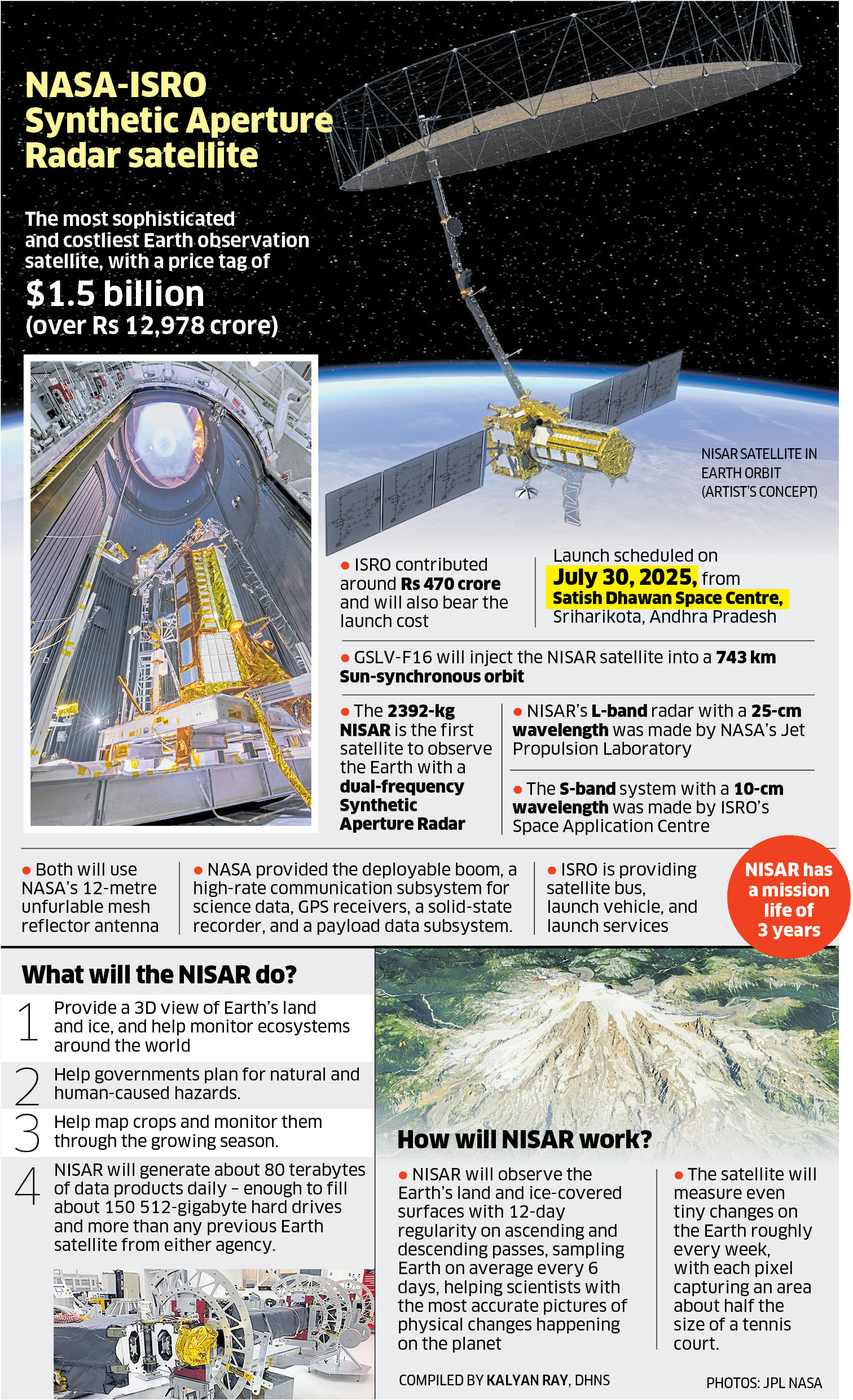
About NISAR (NASA–ISRO Synthetic Aperture Radar):
- Launch Vehicle: GSLV Mk-II | Launch Site: Sriharikota, India
- Mission Life: 3 years (planned); 5+ years (design)
- Orbit: Sun-synchronous polar orbit at 747 km with 98.4° inclination
- Objective: High-precision monitoring of Earth’s surface changes—tectonics, agriculture, ecosystems, ice, floods, and landslides
- Data Access: Free and near real-time; disaster maps delivered in under 5 hours
- Hardware Contributions:
- NASA: L-band SAR, 12m antenna, avionics
- ISRO: S-band SAR, satellite bus, launch services
- Development and Collaboration:
- Initial Concept: 2007 (NASA); ISRO joined in 2012
- Formal Agreement: 2014
- Investment: NASA – ~$1.16 billion; ISRO – ~$90 million
Key Features of NISAR:
- What is Synthetic Aperture Radar (SAR)?
-
- Operates day/night, all-weather
- Simulates large radar antenna via motion
- Penetrates clouds, vegetation, and soil
- Dual-Band SAR:
-
- L-band SAR (1.257 GHz):
- Deeper penetration; ideal for forests, tectonic shifts, permafrost
- S-band SAR (3.2 GHz):
- Surface details; supports agriculture, flood mapping, biomass tracking
- L-band SAR (1.257 GHz):
- Radar Antenna:
-
- 12-meter deployable mesh reflector
- Resolution: 3–10 m spatial; cm-level vertical
- Swath Width: 240 km
- Imaging Frequency:
-
- Global land/ice coverage every 12 days
- Less frequent in polar zones
- Data Output: Generates 80 TB/day (3x current Earth observatories):
-
- Biomass and cropland maps
- High-resolution flood and infrastructure data
Applications and Impact:
- Disaster Relief: Before-and-after imagery for planning
- Climate Monitoring: Glacier melt, forest degradation
- Agriculture: Crop health, rotation, food security
- Infrastructure: Detects land subsidence (dams, cities)
- Strategic Value:
- Most powerful Earth-observing radar satellite
- First with dual SAR payload
- Strengthens India–US space partnership (Artemis, human spaceflight)
| [UPSC 2010] Question: In the context of space technology, what is Bhuvan, recently in the news ?
Options: (a) A mini satellite launched by ISRO for promoting the distance education in India (b) The name given to the next Moon Impact Probe, for Chandrayaan-II (c) A geoportal of ISRO with 3D imaging capabilities of India* (d) A space telescope developed by India |

