💥Join UPSC 2027,2028 Mentorship (July Batch) + XFactor Notes & Microthemes PDF

Subject: Infrastructure Sector

  • Mumbai-Ahmedabad High-Speed Rail (MAHSR)

    Why in News?

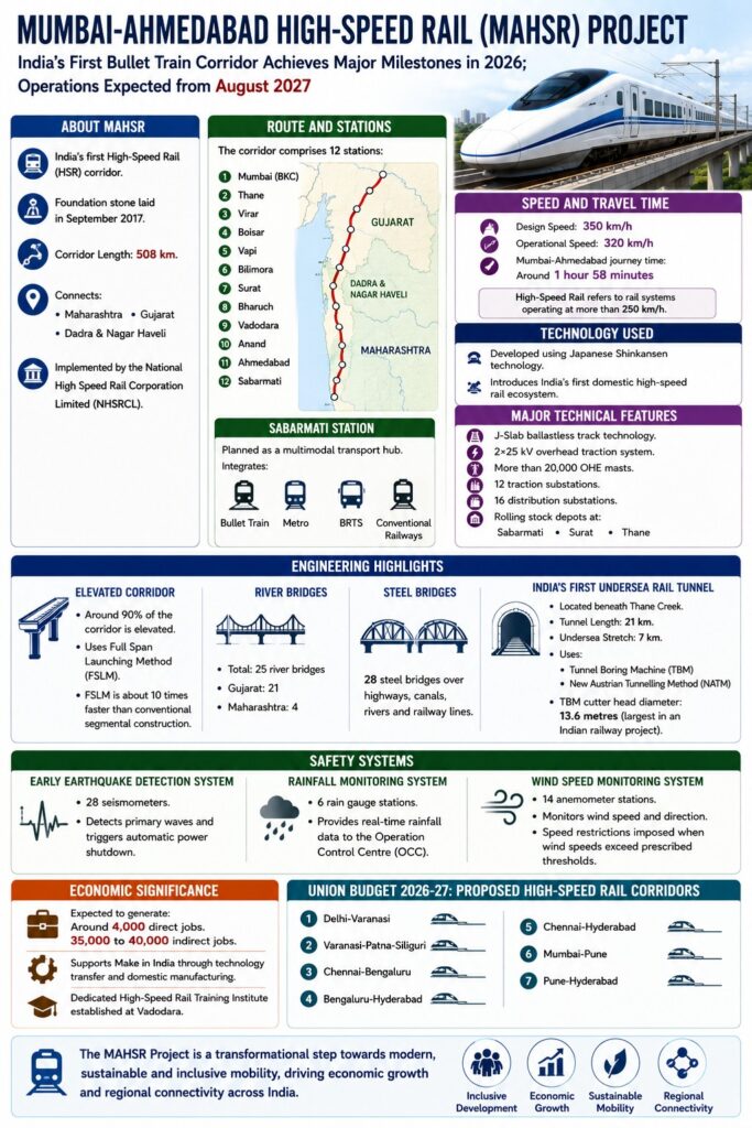
    The Mumbai-Ahmedabad High-Speed Rail (MAHSR) Project, India’s first bullet train corridor, has achieved major construction milestones in 2026 and is expected to commence operations from August 2027.

    About MAHSR

    • India’s first High-Speed Rail (HSR) corridor.
    • Foundation stone laid in September 2017.
    • Corridor Length: 508 km.
    • Connects: Maharashtra, Gujarat, and Dadra & Nagar Haveli
    • Implemented by the National High Speed Rail Corporation Limited (NHSRCL).
    • The corridor comprises 12 stations
    • Sabarmati Station: Planned as a multimodal transport hub.
    • Integrates: Bullet Train, Metro, BRTS, and Conventional Railways.

    Speed and Travel Time

    • Design Speed: 350 km/h
    • Operational Speed: 320 km/h
    • Mumbai-Ahmedabad journey time: Around 1 hour 58 minutes
    • High-Speed Rail refers to rail systems operating at more than 250 km/h.

    Technology Used

    • Developed using Japanese Shinkansen technology.
    • Introduces India’s first domestic high-speed rail ecosystem.

    Major Technical Features

    • J-Slab ballastless track technology.
    • 2×25 kV overhead traction system.
    • More than 20,000 OHE masts (Overhead Equipment Mast) is a vital vertical steel support used in railway electrification
    • 12 traction substations (electrical substation that converts power from the public electricity grid into the specific voltage, current, and frequency required to power railways, trams, or trolleybuses)
    • 16 distribution substations (electrical facility that receives high-voltage power from transmission or sub-transmission systems and “steps down” the voltage to medium levels).
    • Rolling stock depots at: Sabarmati, Surat, and Thane.

    Engineering Highlights

    Elevated Corridor

    • Around 90% of the corridor is elevated.
    • Uses Full Span Launching Method (FSLM).
    • FSLM is about 10 times faster than conventional segmental construction.
    • River Bridges: Total: 25 river bridges: Gujarat: 21. Maharashtra: 4.
    • Steel Bridges: 28 steel bridges over highways, canals, rivers and railway lines.

    India’s First Undersea Rail Tunnel

    • Located beneath Thane Creek.
    • Tunnel Length: 21 km.
    • Undersea Stretch: 7 km.
    • Uses: Tunnel Boring Machine (TBM) and New Austrian Tunnelling Method (NATM).
    • TBM cutter head diameter: 13.6 metres (largest in an Indian railway project).

    Safety Systems

    • Early Earthquake Detection System: 28 seismometers. Detects primary waves and triggers automatic power shutdown.
    • Rainfall Monitoring System: 6 rain gauge stations. Provides real-time rainfall data to the Operation Control Centre (OCC).
    • Wind Speed Monitoring System: 14 anemometer stations. Monitors wind speed and direction. Speed restrictions imposed when wind speeds exceed prescribed thresholds.

    Economic Significance

    • Expected to generate: Around 4,000 direct jobs. 35,000 to 40,000 indirect jobs.
    • Supports Make in India through technology transfer and domestic manufacturing.
    • Dedicated High-Speed Rail Training Institute established at Vadodara.

    Union Budget 2026-27: Proposed High-Speed Rail Corridors

    • Delhi-Varanasi, Varanasi-Patna-Siliguri, Chennai-Bengaluru, Bengaluru-Hyderabad, Chennai-Hyderabad, Mumbai-Pune, and Pune-Hyderabad

    [2023] Consider the following statements :
    1. In a seismograph, P waves are recorded earlier than S waves.
    2. In P waves, the individual particles vibrate to and fro in the direction of wave propagation, whereas in S waves, the particles vibrate up and down at right angles to the direction of wave propagation.
    Which of the statements given above is/are correct?

    [A] 1 only

    [B] 2 only

    [C] Both 1 and 2

    [D] Neither 1 nor 2
  • Zojila Tunnel: The challenge of digging through the Himalays

    Why in the news?

    The near-completion breakthrough of the Zojila Tunnel, being constructed at an altitude of 11,578 feet, marks one of India’s most ambitious and technically demanding infrastructure achievements.

    What is the Zojila Tunnel?

    1. The Zojila Tunnel is a 13-km bi-directional road tunnel being constructed beneath the Zojila Pass in the Himalayas. 
    2. Located at an elevation of 11,578 feet, it aims to provide all-weather connectivity between Kashmir Valley and Ladakh. 
    3. The project is among India’s most challenging infrastructure undertakings due to the complex geological and environmental conditions associated with Himalayan terrain.

     How does Himalayan geology make tunnel construction exceptionally difficult?

    1. Young Fold Mountains: The Himalayas are geologically young and remain tectonically active, resulting in unstable rock formations.
    2. Variable Rock Strata: Rock composition can change within a few metres, creating unpredictable excavation conditions.
    3. Structural Weaknesses: Rock formations contain fractures, cracks, fault zones, and shear zones that reduce stability.
    4. Loose Geological Material: Engineers encounter loose rocks, boulders, and weak strata requiring different support systems.
    5. Ocean-Floor Origin: Himalayan rocks originated from uplifted seabed deposits, producing highly heterogeneous geological structures.
    FeatureYoung HimalayasOld Mountains (e.g., Aravallis)
    StabilityLowerHigher
    Tectonic ActivityActiveRelatively Stable
    Tunneling RiskHighLower
    Rock UniformityPoorBetter

    Why do altitude and climatic conditions increase construction risks?

    1. High Elevation: Construction occurs at approximately 11,578 feet, reducing worker efficiency and equipment performance.
    2. Extreme Cold: Temperatures may fall to -30°C.
    3. Harsh Winters: Severe weather limits construction windows.
    4. Avalanche Threats: Snow avalanches create risks for workers and infrastructure.
    5. Operational Challenges: Combustion engines and heavy machinery experience reduced efficiency at high altitude.

    Why is water ingress one of the biggest engineering challenges in the Himalayas?

    1. Stored Water Reservoirs: Mountains contain large volumes of groundwater trapped within rock layers.
    2. Snowmelt Contribution: Melting snow continuously adds to underground water systems.
    3. Water Ingress: Excavation frequently intersects water-bearing zones.
    4. Hydrostatic Pressure: Excessive water pressure can destabilize tunnel structures.
    5. Flooding Risk: Uncontrolled seepage may trigger tunnel flooding and structural failures.

    Striking Observation

    1. Massive Water Storage: Geological assessments indicate that Himalayan mountains may contain water volumes comparable to an “ocean’s worth” of stored water.

    Why are shear zones and tectonic stresses particularly dangerous?

    1. Shear Zones: High-strain zones create instability during excavation.
    2. Rock Deformation: Tectonic pressure continuously alters stress distribution.
    3. Collapse Risk: Excavation may trigger localized failures in weak zones.
    4. Dynamic Conditions: Geological conditions often change unexpectedly during drilling.
    5. Engineering Uncertainty: Tunnel design frequently requires real-time modification.

    What safety measures were adopted during the Zojila Tunnel project?

    1. Ventilation Infrastructure: Three shafts were constructed along the tunnel length.
    2. Emergency Response: Shafts provide access for rescue and evacuation operations.
    3. Deep Access Shafts: The first shaft is 474.3 m deep, making it the deepest in India.
    4. Additional Shafts: The second shaft is 367.5 m deep, while the third shaft is 213.5 m deep.
    5. Operational Safety: Ventilation systems ensure worker safety during construction and future operation.

    How does the New Austrian Tunnelling Method (NATM) help overcome Himalayan challenges?

    The New Austrian Tunneling Method (NATM) is a modern, observational tunneling approach that reinforces the surrounding rock or soil, allowing it to deform slightly and become part of the tunnel’s primary load-bearing structure.

    1. Selective Excavation: Facilitates controlled blasting based on rock conditions.
    2. Sequential Construction: Excavation proceeds in stages rather than full-face excavation.
    3. Top-Heading Method: Upper tunnel section is excavated first, followed by the lower section.
    4. Adaptive Design: Allows modifications according to changing geological conditions.
    5. Risk Reduction: Enhances stability in weak and variable rock formations.

    About the NATM

    Principle: “The surrounding rock mass itself becomes part of the support system.”

    Key Components

    1. Shotcrete: Sprayed concrete for immediate stabilization.
    2. Rock Bolts: Reinforce fractured rock.
    3. Monitoring Systems: Continuous assessment of rock behaviour.
    4. Flexible Design: Engineering response adjusted to site conditions.

    How are water and structural stability managed during excavation?

    1. Drainage Pipes: Facilitate controlled water discharge.
    2. Pressure Management: Prevents buildup of hydrostatic pressure.
    3. Rock Bolting: Stabilizes fractured rock masses.
    4. Shotcrete Lining: Binds loose rock surfaces.
    5. Alignment Modification: Tunnel route can be altered to bypass weak geological sections.
    6. Site-Specific Design: Tunnel shape and support configuration vary according to local conditions.

    Why does the Zojila Tunnel have strategic significance beyond engineering?

    1. All-Weather Connectivity: Reduces dependence on the seasonally closed Zojila Pass.
    2. Regional Integration: Strengthens connectivity between Kashmir and Ladakh.
    3. Defence Logistics: Improves movement of military personnel and supplies.
    4. Economic Development: Facilitates tourism, trade, and local livelihoods.
    5. National Infrastructure Capacity: Demonstrates India’s capability to execute mega-projects in difficult terrain.

    Conclusion

    The Zojila Tunnel demonstrates the intersection of strategic infrastructure, geological science, and engineering innovation in one of the world’s most challenging mountain environments. Its construction highlights the necessity of adaptive engineering, advanced tunnelling techniques, and robust safety systems for infrastructure development in the Himalayas. The project serves as a model for future high-altitude infrastructure while strengthening regional connectivity, national security, and economic integration.

    Value Addition

    Major Himalayan Infrastructure Projects

    1. Zojila Tunnel: Kashmir-Ladakh connectivity.
    2. Atal Tunnel: Rohtang Pass, Himachal Pradesh.
    3. Sela Tunnel: Arunachal Pradesh.
    4. Z-Morh Tunnel: Sonamarg connectivity.

    PYQ Relevance

    [UPSC 2016] The Himalayas are highly prone to landslides. Discuss the causes and suggest suitable measures of mitigation.

    Linkage: The question examines the geological fragility, instability, and hazard-prone nature of the Himalayan mountain system. The Zojila Tunnel highlights how young Himalayan geology creates major engineering and disaster-management challenges during infrastructure construction.

  • Infrastructure at the Core of India’s Development (PIB)

    Why in the news?

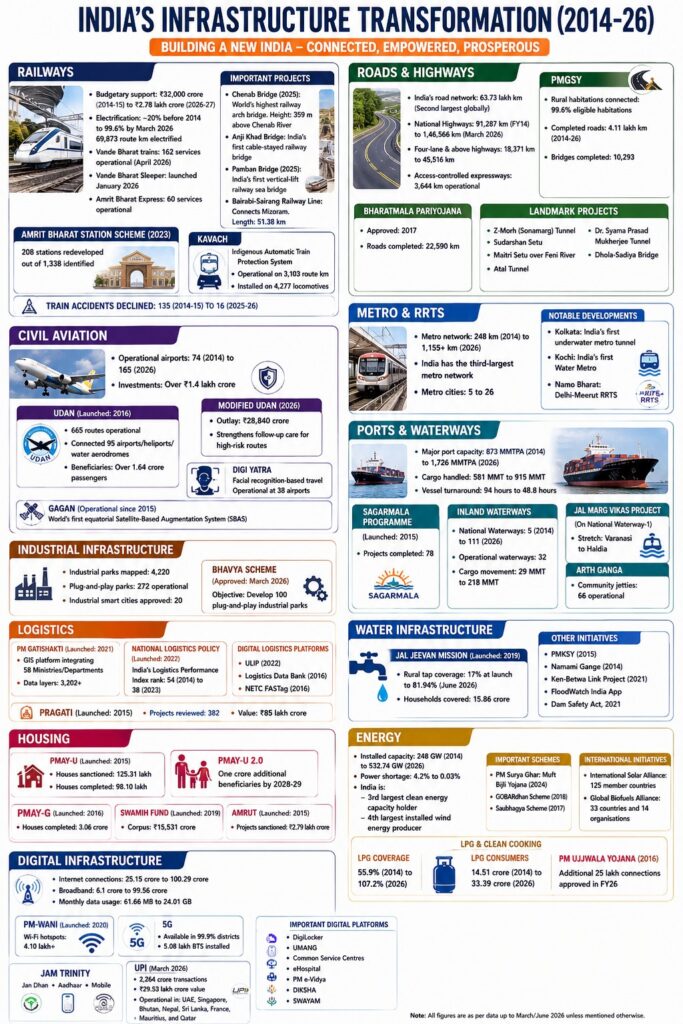
    The Government highlighted major infrastructure achievements over the past 12 years across transport, logistics, water, housing, energy, and digital sectors, emphasizing their role in achieving Viksit Bharat 2047.

    1. Railways

    • Railway budgetary support increased from ₹32,000 crore (2014-15) to ₹2.78 lakh crore (2026-27).
    • Railway electrification:
      • About 20% before 2014
      • 99.6% by March 2026
      • 69,873 route km electrified.
    • Vande Bharat trains: 162 services operational (April 2026).
    • Vande Bharat Sleeper: launched in January 2026.
    • Amrit Bharat Express: 60 services operational.
    • Mumbai-Ahmedabad High-Speed Rail Corridor
      • Length: 508 km
      • Design speed: 320 kmph.
    • Amrit Bharat Station Scheme (2023): 208 stations redeveloped out of 1,338 identified.
    • Kavach:
      • Indigenous Automatic Train Protection System.
      • Operational on 3,103 route km.
      • Installed on 4,277 locomotives.
    • Train accidents declined from 135 (2014-15) to 16 (2025-26).

    Important Railway Projects

    • Chenab Bridge (2025): World’s highest railway arch bridge. Height: 359 m above Chenab River.
    • Anji Khad Bridge: India’s first cable-stayed railway bridge.
    • Pamban Bridge (2025): India’s first vertical-lift railway sea bridge.
    • Bairabi-Sairang Railway Line: Connects Mizoram. Length: 51.38 km.

    Roads and Highways

    • India’s road network: 63.73 lakh km and Second largest globally.
    • National Highways:
      • 91,287 km (FY14)
      • 1,46,566 km (March 2026).
    • Four-lane and above highways: 18,371 km to 45,516 km.
    • Access-controlled expressways: 3,644 km operational.

    PMGSY

    • Rural habitations connected: 99.6% eligible habitations.
    • Completed roads: 4.11 lakh km (2014-26).
    • Bridges completed: 10,293.

    Bharatmala Pariyojana

    • Approved: 2017.
    • Roads completed: 22,590 km.

    Landmark Projects

    • Z-Morh (Sonamarg) Tunnel, Sudarshan Setu, Maitri Setu over Feni River, Atal Tunnel, Dr. Syama Prasad Mukherjee Tunnel, Dhola-Sadiya Bridge.

    2. Civil Aviation

    • Operational airports: 74 (2014) and 165 (2026).
    • Investments: Over ₹1.4 lakh crore.

    UDAN

    • Launched: 2016.
    • Routes operational: 665 routes.
    • Connected: 95 airports/heliports/water aerodromes.
    • Beneficiaries: Over 1.64 crore passengers.
    • Modified UDAN (2026): Outlay: ₹28,840 crore.

    Digi Yatra

    • Facial recognition-based travel.
    • Operational at 38 airports.

    GAGAN

    • Operational since 2015.
    • World’s first equatorial Satellite-Based Augmentation System (SBAS).

    3. Metro and RRTS

    • Metro network: 248 km (2014) to 1,155+ km (2026).
    • India has the third-largest metro network.
    • Metro cities: 5 to 26.

    Notable Developments

    • Kolkata: India’s first underwater metro tunnel.
    • Kochi: India’s first Water Metro.
    • Namo Bharat: Delhi-Meerut RRTS.

    4. Ports and Waterways

    • Major port capacity: 873 MMTPA (2014) to 1,726 MMTPA (2026).
    • Cargo handled: 581 MMT to 915 MMT.
    • Vessel turnaround: 94 hours to 48.8 hours.

    Sagarmala Programme

    • Launched: 2015.
    • Projects completed: 78.

    Inland Waterways

    • National Waterways: 5 (2014) to 111 (2026).
    • Operational waterways: 32.
    • Cargo movement: 29 MMT to 218 MMT.

    Jal Marg Vikas Project

    • On National Waterway-1.
    • Stretch: Varanasi to Haldia.

    Arth Ganga

    • Community jetties: 66 operational.

    5. Industrial Infrastructure

    • Industrial parks mapped: 4,220.
    • Plug-and-play parks: 272 operational.
    • Industrial smart cities approved: 20.

    BHAVYA Scheme

    • Approved: March 2026.
    • Objective: Develop 100 plug-and-play industrial parks.

    6. Logistics

    PM GatiShakti

    • Launched: 2021.
    • GIS platform integrating: 58 Ministries/Departments.
    • Data layers: 3,202+.

    National Logistics Policy

    • Launched: 2022.
    • India’s Logistics Performance Index rank: 54 (2014) to 38 (2023).

    Digital Logistics Platforms

    • ULIP (2022).
    • Logistics Data Bank (2016).
    • NETC FASTag (2016).

    PRAGATI

    • Launched: 2015.
    • Projects reviewed: 382.
    • Value: ₹85 lakh crore.

    7. Water Infrastructure

    Jal Jeevan Mission

    • Launched: 2019.
    • Rural tap coverage: 17% at launch to 81.94% (June 2026).
    • Households covered: 15.86 crore.

    Other Initiatives

    • PMKSY (2015), Namami Gange (2014), Ken-Betwa Link Project (2021, FloodWatch India App, and Dam Safety Act, 2021.

    8. Housing

    PMAY-U

    • Launched: 2015.
    • Houses sanctioned: 125.31 lakh.
    • Houses completed: 98.10 lakh.
    • PMAY-U 2.0: One crore additional beneficiaries by 2028-29.

    PMAY-G

    • Launched: 2016.
    • Houses completed: 3.06 crore.

    SWAMIH Fund

    • Launched: 2019.
    • Corpus: ₹15,531 crore.

    AMRUT

    • Launched: 2015.
    • Projects sanctioned: ₹2.79 lakh crore.

    9. Energy

    • Installed capacity: 248 GW (2014) to 532.74 GW (2026).
    • Power shortage: 4.2% to 0.03%.

    Renewable Energy

    India is: 3rd largest clean energy capacity holder and 4th largest installed wind energy producer.

    Important Schemes

    • PM Surya Ghar: Muft Bijli Yojana (2024).
    • GOBARdhan Scheme (2018).
    • Saubhagya Scheme (2017).

    International Initiatives

    • International Solar Alliance: 125 member countries.
    • Global Biofuels Alliance: 33 countries and 14 organisations.

    10. LPG and Clean Cooking

    • LPG coverage: 55.9% (2014) to 107.2% (2026).
    • LPG consumers: 14.51 crore to 33.39 crore.

    PM Ujjwala Yojana

    • Launched: 2016.
    • Additional 25 lakh connections approved in FY26.

    11. Digital Infrastructure

    • Internet connections: 25.15 crore to 100.29 crore.
    • Broadband:6.1 crore to 99.56 crore.
    • Monthly data usage: 61.66 MB to 24.01 GB.

    PM-WANI

    • Launched: 2020.
    • Wi-Fi hotspots: 4.10 lakh+.

    5G

    • Available in 99.9% districts.
    • 5.08 lakh BTS installed.

    JAM Trinity

    • Jan Dhan, Aadhaar and Mobile.

    UPI

    • March 2026: 2,264 crore transactions and ₹29.53 lakh crore value.
    • Operational in UAE, Singapore, Bhutan, Nepal, Sri Lanka, France, Mauritius, and Qatar.

    Important Digital Platforms

    • DigiLocker, UMANG, Common Service Centres, eHospital, PM e-Vidya, DIKSHA, SWAYAM.

    [2025] Consider the following statements:
    I. Indian Railways have prepared a National Rail Plan (NRP) to create a future ready railway system by 2028.
    II. Kavach’ is an Automatic Train Protection system, development in collaboration with Germany.
    III. ‘Kavach’ system consists of RFID tags fitted on track in station section.
    Which of the statements given above are not correct?

    [A] I and II only

    [B] II and III only

    [C] I and III only

    [D] I, II and III

  • Zojila Tunnel

    Why in the news?

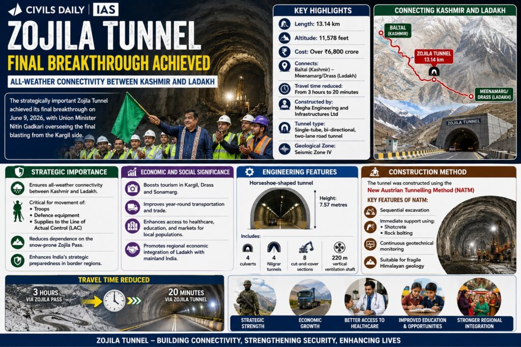
    The strategically important Zojila Tunnel achieved its final breakthrough on June 9, 2026, with Union Minister Nitin Gadkari overseeing the final blasting from the Kargil side. The tunnel will provide all-weather connectivity between Kashmir and Ladakh.

    Key Highlights

    • Length: 13.14 km
    • Altitude: 11,578 feet
    • Cost: Over ₹6,800 crore
    • Connects: Baltal (Kashmir) and Meenamarg/Drass (Ladakh)
    • Travel time reduced: From 3 hours to 20 minutes
    • Constructed by: Megha Engineering and Infrastructures Ltd
    • Tunnel type: Single-tube, bi-directional, two-lane road tunnel
    • Geological Zone: Seismic Zone IV

    Strategic Importance

    • Ensures all-weather connectivity between Kashmir and Ladakh.
    • Critical for the movement of Troops, Defence equipment, and Supplies to the Line of Actual Control (LAC)
    • Reduces dependence on the snow-prone Zojila Pass.
    • Enhances India’s strategic preparedness in border regions.

    Construction Method

    • The tunnel was constructed using the: New Austrian Tunnelling Method (NATM)

    Key features of NATM:

    • Sequential excavation
    • Immediate support using: Shotcrete and Rock bolting
    • Continuous geotechnical monitoring
    • Suitable for fragile Himalayan geology

    Q. With reference to India’s projects on connectivity, consider the following statements::
    1. East-West Corridor under Golden Quadrilateral Project connects Dibrugarh and Surat.
    2. Trilateral Highway connects Moreh in Manipur and Chiang Mai in Thailand via Myanmar.
    3. Bangladesh- China- India- Myanmar Economic Corridor connects Varanasi in Uttar Pradesh with Kunming in China.
    How many of the above statements are correct?

    [A] Only one

    [B] Only two

    [C] All three

    [D] None

  • [8th June 2026] The Hindu OpED: From borderland to India’s strategic resource frontier

    Mentor’s Comment

    India’s search for critical minerals has brought the Northeast into the national strategic spotlight. Government narratives increasingly portray states such as Arunachal Pradesh, Manipur, Meghalaya, and Mizoram as resource-rich frontiers capable of supporting India’s clean energy transition and industrial ambitions. This highlights a significant shift in how India views the Northeast. Traditionally it was framed through the lens of borders, security, insurgency, and connectivity.

    Why is the Northeast Emerging as India’s Strategic Resource Frontier?

    1. Critical Mineral Demand: Expanding demand for lithium, cobalt, graphite, nickel, and rare earth elements is reshaping global industrial and geopolitical competition.
    2. Energy Transition: Batteries, electric vehicles, renewable energy technologies, and energy storage systems depend heavily on critical minerals.
    3. Technological Manufacturing: Semiconductors and advanced manufacturing require secure access to strategic minerals.
    4. Defence Applications: Defence technologies increasingly rely on mineral-intensive supply chains.
    5. Strategic Autonomy: Reduces dependence on external suppliers and strengthens supply-chain resilience.
    6. Resource Potential: Geological surveys indicate significant mineral potential across several Northeastern states.

    How Has Government Discourse on the Northeast Changed?

    1. Borderland Narrative: The Northeast was historically discussed through issues of insurgency, territorial security, border management, and connectivity.
    2. Security-Centric Approach: Infrastructure projects were often justified as instruments of strategic access and territorial integration.
    3. Resource Frontier Narrative: The region is increasingly portrayed as a source of strategic minerals critical for national development.
    4. Expanded Strategic Significance: Discussions now combine security, resource access, industrial policy, and geopolitical competitiveness.
    5. National Economic Integration: Resource development is becoming central to how the region is represented in national policymaking.

    What Is the Scale of Critical Mineral Exploration in the Northeast?

    1. Exploration Expansion: Geological Survey of India undertook 43 critical mineral exploration projects in northeastern states during the 2022-23, 2023-24 and 2024-25 field seasons.
    2. Minerals Covered: Exploration focused on graphite, vanadium, lithium, rare earth elements, nickel and cobalt.
    3. Geographical Spread: Activities expanded across Arunachal Pradesh, Meghalaya, Assam, Nagaland and Manipur.
    4. Manipur Projects: Recent exploration initiatives involve nickel, cobalt and chromium deposits.
    5. Long-Term Potential: Geological surveys have consistently pointed toward significant mineral prospects in the region.

    Why Does the ‘Resource Frontier’ Narrative Oversimplify the Northeast’s Reality?

    1. Frontier Concept: The term suggests empty spaces waiting for discovery, development, and extraction.
    2. Historical Assumption: Frontiers are often portrayed as regions awaiting integration into the national economy.
    3. Social Reality: The Northeast already contains complex social, political, cultural, and economic systems.
    4. Existing Institutions: Local governance structures, customary institutions, and traditional land-management systems are already deeply embedded.
    5. Identity and Memory: Land carries historical, cultural, and political significance beyond its economic value.
    6. Political Meaning: Resource extraction enters territories that already possess established histories and institutions.

    Why Are Land and Ownership Questions Central to Resource Development?

    1. Customary Land Systems: Many communities maintain long-standing customary ownership arrangements.
    2. Authority Structures: Land is closely linked to local political authority and governance.
    3. Identity Linkages: Ownership often forms part of community identity and historical memory.
    4. Representation Concerns: Resource decisions raise questions regarding who participates in decision-making.
    5. Trust Deficit: Development projects are frequently assessed through local perceptions of trust and inclusion.
    6. Beyond Economics: Land debates encompass social legitimacy, rights, and political recognition.

    How Do Existing Regional Conflicts Influence Resource Politics?

    1. Manipur Experience: Years of violence and displacement have intensified debates over land and territorial arrangements.
    2. Ecological Vulnerability: Communities increasingly raise concerns regarding environmental impacts of extraction.
    3. Ownership Disputes: Resource projects often intersect with unresolved questions of land rights.
    4. Political Inclusion: Communities evaluate projects through the lens of representation and participation.
    5. Conflict Sensitivity: Resource development in fragile regions may acquire meanings beyond economic development.

    Can Resource Development Create New Governance Challenges?

    1. Institutional Capacity: Extraction may proceed faster than institutions capable of managing its consequences.
    2. Uneven Development: The Northeast has historically experienced uneven infrastructure and economic growth.
    3. Connectivity Mismatch: Infrastructure projects have sometimes emerged without corresponding economic ecosystems.
    4. Participation Deficit: Strategic priorities have often overshadowed local participation and consultation.
    5. Social Risks: Rapid extraction may reproduce tensions if benefits are unevenly distributed.
    6. Governance Imperative: Resource development requires strong institutions, transparency, and social safeguards.

    Why Is Inclusion as Important as Extraction?

    1. Benefit Sharing: Local communities seek meaningful economic participation.
    2. Employment Opportunities: Resource projects can address long-standing developmental deficits.
    3. Political Legitimacy: Inclusive governance strengthens acceptance of projects.
    4. Community Ownership: Participation improves trust and reduces conflict.
    5. Sustainable Development: Long-term success depends on balancing strategic objectives with local aspirations.

    Conclusion

    The Northeast’s emergence as a critical mineral hub presents India with a strategic opportunity to strengthen resource security, support the energy transition, and reduce external dependence. However, the region cannot be treated merely as a repository of minerals waiting for extraction. Sustainable success will depend on reconciling national developmental priorities with local aspirations, customary land rights, ecological safeguards, and participatory governance. The real challenge is not only to extract resources from the Northeast, but to ensure that its people become equal stakeholders in the region’s transformation from a borderland to a strategic resource frontier.

  • In India, the ports are categorized as major and non-major ports.

    In India, the ports are categorized as major and non-major ports.
    Which one of the following is a non-major port ?

  • In which one of the following States has India’s largest private sector sea port been commissioned recently

    In which one of the following States has India’s largest private sector sea port been commissioned recently ?

  • The SEZ Act, 2005 which came into effect in February 2006 has certain objectives. In this context, consider the following

    The SEZ Act, 2005 which came into effect in February 2006 has certain objectives. In this context, consider the following :
    1. Development of infrastructure facilities.
    2. Promotion of investment from foreign sources.
    3. Promotion of exports of services only.
    Which of the above are the objectives of this Act ?

  • What is/are the recent policy initiative(s) of Government of India to promote the growth of manufacturing sector

    What is/are the recent policy initiative(s) of Government of India to promote the growth of manufacturing sector?
    1. Setting up of National Investment and Manufacturing Zones
    2. Providing the benefit of ‘single window clearance’
    3. Establishing the Technology Acquisition and Development Fund (TADF)

  • Which one among the following industries is the maximum consumer of water in India

    Which one among the following industries is the maximum consumer of water in India?