The Peninsular Drainage:
The Peninsular drainage system is older than the Himalayan one. This is evident from the broad, largely-graded shallow valleys, and the maturity of the rivers.
Evolution:
Three major geological events in the distant past have shaped the present drainage systems of Peninsular India:
- Subsidence of the western flank of the Peninsula leading to its submergence below the sea during the early tertiary period. Generally, it has disturbed the symmetrical plan of the river on either side of the original watershed and left just the upper parts of west flowing rivers above the sea level.
- Upheaval of the Himalayas when the northern flank of the Peninsular block was subjected to subsidence and the consequent trough faulting. The Narmada and The Tapi flow in trough faults and fill the original cracks with their detritus materials. Hence, there is a lack of alluvial and deltaic deposits in these rivers.
- Slight tilting of the Peninsular block from north-west to the southeastern direction gave orientation to the entire drainage system towards the Bay of Bengal during the same period.
River-Systems:
The peninsular river system can be categorised into the following sections:
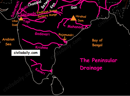
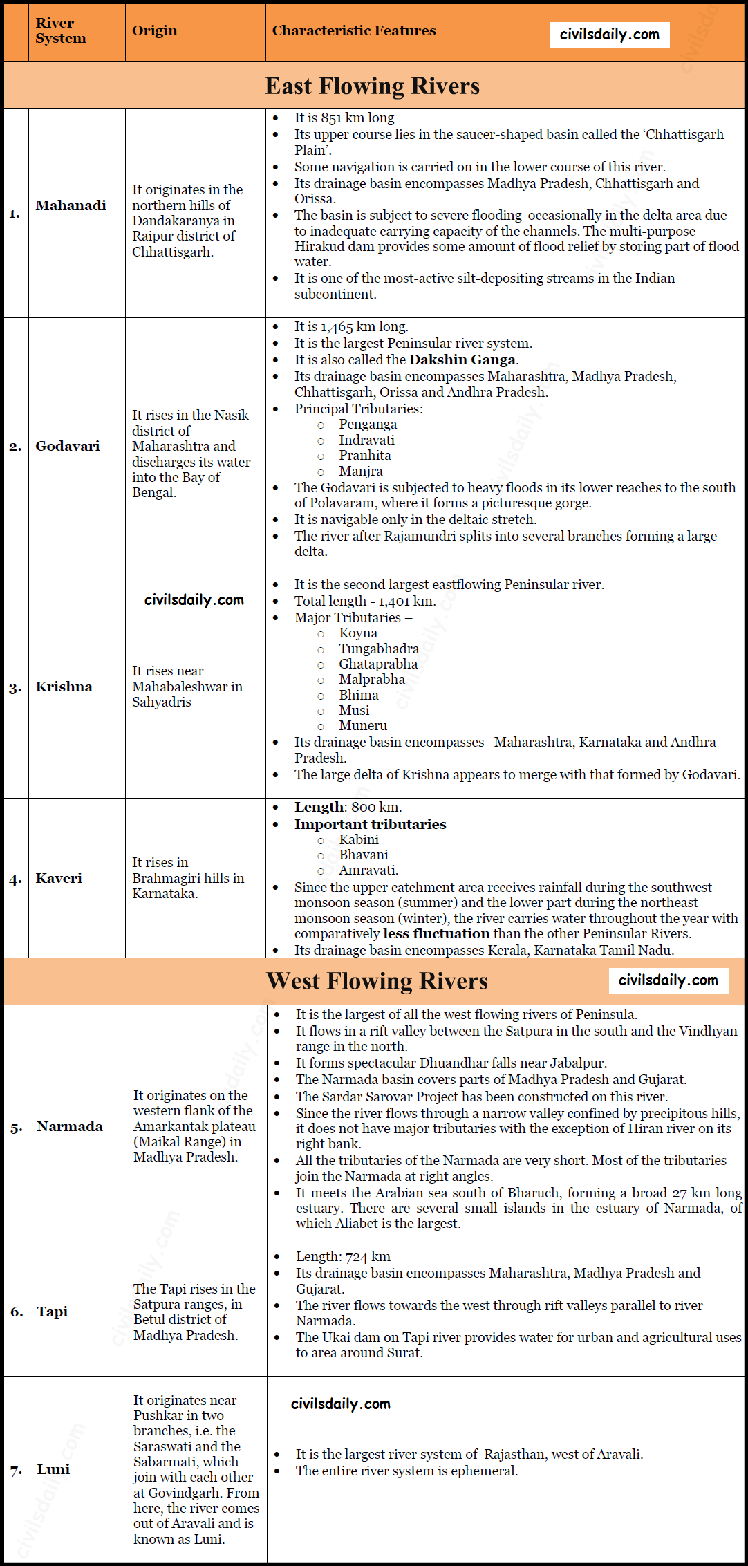
- The East flowing rivers – the Mahanadi, the Godavari, the Krishna and the Cauvery flow eastwards and drain into the Bay of Bengal. These rivers make deltas at their mouths.
- The West flowing rivers:
- Narmada and Tapi along with other small rivers originating from the Western Ghats and falling in the Arabian Sea form estuaries in place of deltas. This is due to the fact that these rivers, especially Narmada and Tapi, flow through hard rocks and are not able to form distributaries before they enter the sea.
- Although these west flowing rivers of Sahyadri form only about 3% of the areal extent of basins of India, they contain about 18% of the country’s water resources.
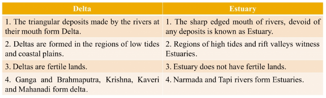
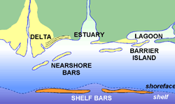
Wondering what is the difference between a delta and an estuary? Let’s see:
 Source
Source
- The Western Ghats running close to the western coast act as a water divide between the major Peninsular Rivers discharging their water in the Bay of Bengal and the small rivulets joining the Arabian Sea.
- The Chambal, the Sind, the Betwa, the Ken, the Son, originating in the northern part of the Peninsula belong to the Ganga river system.
- The Peninsular rivers are characterized by fixed courses, absence of meanders and non-perennial flow of water. The Narmada and the Tapi which flow through the rift valley are, however, exceptions.
A brief account of the major Peninsular river systems is given below:
Smaller rivers flowing Towards the West:
The rivers flowing towards the Arabian Sea have short courses ( Because their origins lie closer to the sea, and the Western Ghats act as a water divide). Several of these small rivers are important for the production of hydroelectricity because of steep slopes and waterfalls.
Gujarat:
- The Shetruniji – It rises near Dalkahwa in Amreli district.
- The Bhadra – It originates near Aniali village in Rajkot district.
- The Dhadhar rises near Ghantar village in Panchmahal district.
- Sabarmati
- Mahi
Maharashtra:
- The Vaitarna rises from the Trimbak hills in Nasik district
- The Kalinadi rises from Belgaum district and falls in the Karwar Bay.
- The source of Bedti river lies in Hubli Dharwar and traverses a course of 161 km.
- The Sharavati is another important river in Karnataka flowing towards the west. The Sharavati originates in Shimoga district of Karnataka and drains a catchment area of 2,209 sq. km. The famous Jog or Gersoppa Falls (289m) made by Sharavati river are the highest untiered waterfalls in India.
Goa:
- Mandovi
- Juari
Kerala:
- Bharathapuzha – It is the largest river of Kerala. It is also known as Ponnani. It originates from Annamalai hills and flows into the Arabian Sea at a place called Ponnani.
- The Periyar – It is the longest and the second largest river of Kerala. [Largeness of a river is related to its basin size and the volume of water flowing in the river. At the same time when we say that a river is the longest, it means that we are referring to its geographical length]
- The Pamba river – It falls in the Vembanad lake.
Small Rivers Flowing towards the East:
There are small rivers which join the Bay of Bengal, though small, these are important in their own right.
- The Subarnrekha
- the Baitarni
- the Brahmani
- the Vamsadhara
- the Penner
- the Palar
- the Vaigai

the geography section is excellent and useful very much for last time revision. thank you TEAM
Vaigai river: Originates from Periyar Plateau of Western Ghat. Tributaries are Suruliyaru, Mullaiyaru, Varaganadhi, Manjalaru, Kottagudi, Kridhumaal and Upparu. Flows into Palk Strait, TN . It gets 80 % of water from Periyar dam. 20 % from watershed of Megamalai region during northeast monsoon. Declaration of Srivilliputhur- Megamalai Tiger Reserve also gives protection to heritage Vaigai river from land encroachment, sand mining.
It flows through Madurai, capital of pandyas. Mentioned in sangam lit. Colonial deforestation in megamalai region for commercial plantations. great famine in 1870s. British diverted water from Periyar dam to Vaigai river through tunnel.