Let’s begin with the first physiographic division. It consists of:
- The Himalayas, and
- The Northeastern hills (Purvanchal).
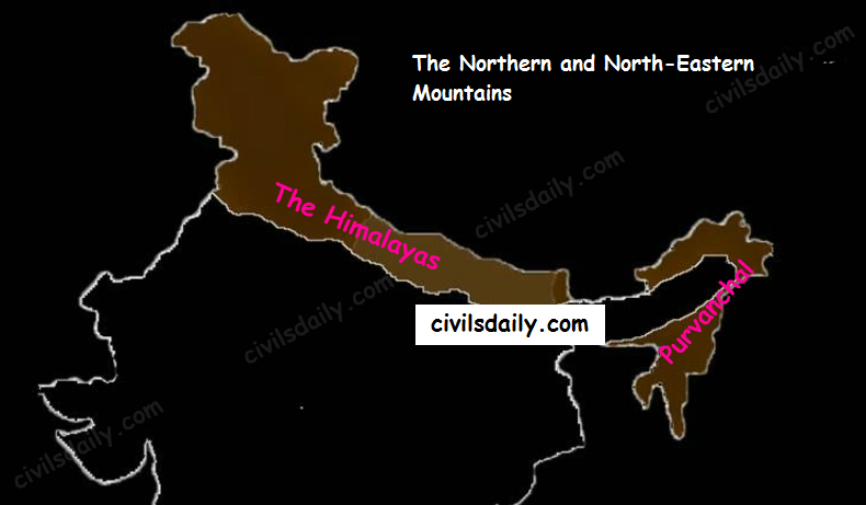
A) The Himalayas:
The name “Himalaya” means “the abode or house of snow” in Sanskrit (i.e. hima “snow”, and ālaya “abode or house”). The Himalayas are the highest and longest of all young fold mountains of the world. The Pamir, known as the roof of the world, connects the Himalayas with the high ranges of Central Asia.
Let’s begin by understanding how the Himalayas came into being:
Origin and development:
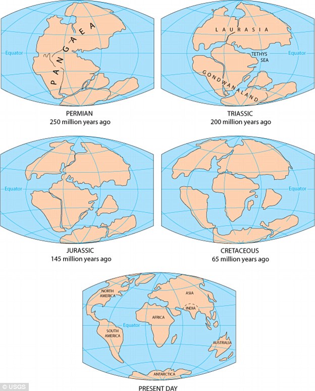
According to the theory of Continental Drift, the world was made up of a single continent through most of the geologic time. That continent eventually separated and drifted apart; forming the seven continents we have today.
Source
- About 200 million years ago: Pangaea broke apart leading to the formation of two landmasses – “Laurasia in North” and “Gondwanaland in South”. Both the landmasses were separated by a shallow sea called “Tethys Sea”. The size of Tethys sea kept on decreasing due to movement of landmasses towards each other
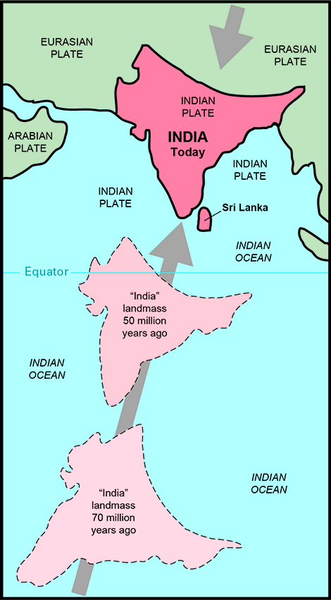
- About 40 to 50 million years ago: The two large landmasses, India and Eurasia, driven by plate movement, collided. As a result, the sediments accumulated in Tethys Sea (brought by rivers) were compressed, squeezed and series of folds were formed, one behind the other, giving birth to folded mountains of the Himalayas.
Source
Recent studies show that India is still moving northwards at the rate of 5cm/year and crashing into the rest of Asia, thereby constantly increasing the height of Himalayas.
Evidence to prove that the Himalayas are still rising:
- Fossil formation found in Shivalik hills:
Similar fossils have also been found in the Tibet Plateau. This indicates that in the past, Tibetan plateau and Shivalik hills shared a common location, similar level and thus similar vegetation, life etc.; then Tibetan plateau got uplifted.
- Desiccation of lakes of Tibet:
In the Tibet plateau, we find deposits which are generally found in lakes. This indicates that lakes once existed in Tibet but because of upliftment the water got discharged and deposits remained.
- Frequent Earthquakes
- Youthful nature of rivers (High erosion, v-shaped valleys etc.)
The North-South Division of the Himalayas
The Himalayas consist of a series of parallel mountain ranges:
- The Greater Himalayan range, which includes:
- The Great Himalayas(Himadri), and
- The Trans-Himalayan range
- The Lesser Himalayas (or Himachal), and
- The Outer Himalayas (or Shiwalik).
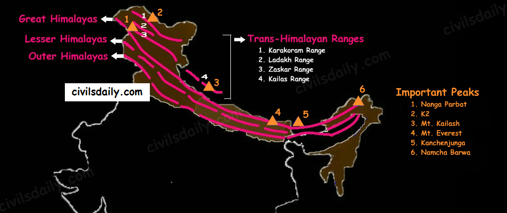
The Himalayan Ranges and Important Peaks
- Formation of these ranges: The Himadri and Himachal ranges of the Himalayas have been formed much before the formation of Siwalik range. The rivers rising in the Himadri and Himachal ranges brought gravel, sand and mud along with them, which was deposited in the rapidly shrinking Tethys Sea. In course of time, the earth movements caused folding of these relatively fresh deposits of sediments, giving rise to the least consolidated Shiwalik range.
- Characteristic Features:
- Notice in the map shown above that the Himalayas form an arcuate curve which is convex to the south. This curved shape of the Himalayas is attributed to the maximum push offered at the two ends on the Indian peninsula during its northward drift. In the north-west, it was done by Aravalis and in the Northeast by the Assam ranges.
- Syntaxis/ Syntaxial bends: The gently arching ranges of the Himalayan mountains on their Western and Eastern extremities are sharply bent southward in deep Knee-bend flexures that are called syntaxial bends. On both the ends, the great mountains appear to bend around a pivotal point. The western point is situated south of the Pamir where the Karakoram meets the Hindu Kush. A similar sharp, almost hairpin bend occurs on the eastern limit of Arunachal Pradesh where the strike of the mountain changes sharply from the Easterly to Southerly trend. Besides these two major bends, there are a number of minor syntaxial bends in other parts of Himalayas.
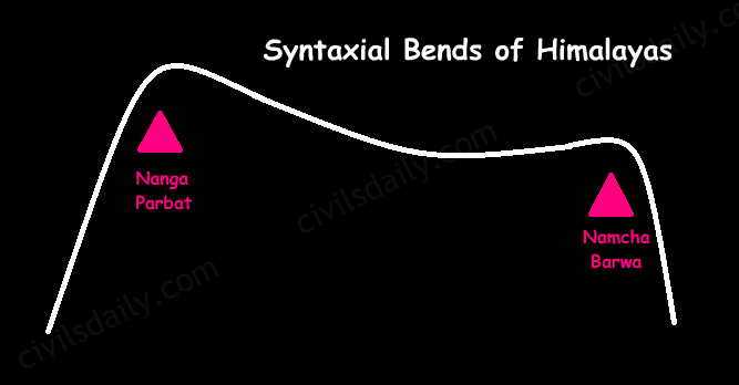
Syntaxial Bends of Himalayas
- The Himalayas are wider in the west than in the east. The width varies from 400 km in Kashmir to 150 km in Arunachal Pradesh.The main reason behind this difference is that the compressive force was more in the east than in the west. That is why high mountain peaks like Mount Everest and Kanchenjunga are present in the Eastern Himalayas.
- The ranges are separated by deep valleys creating a highly dissected topography.
- The southern slopes of the Himalayas facing India are steeper and those facing the Tibetan side are generally gentler.
Let’s take up these Himalayan mountain ranges one by one:
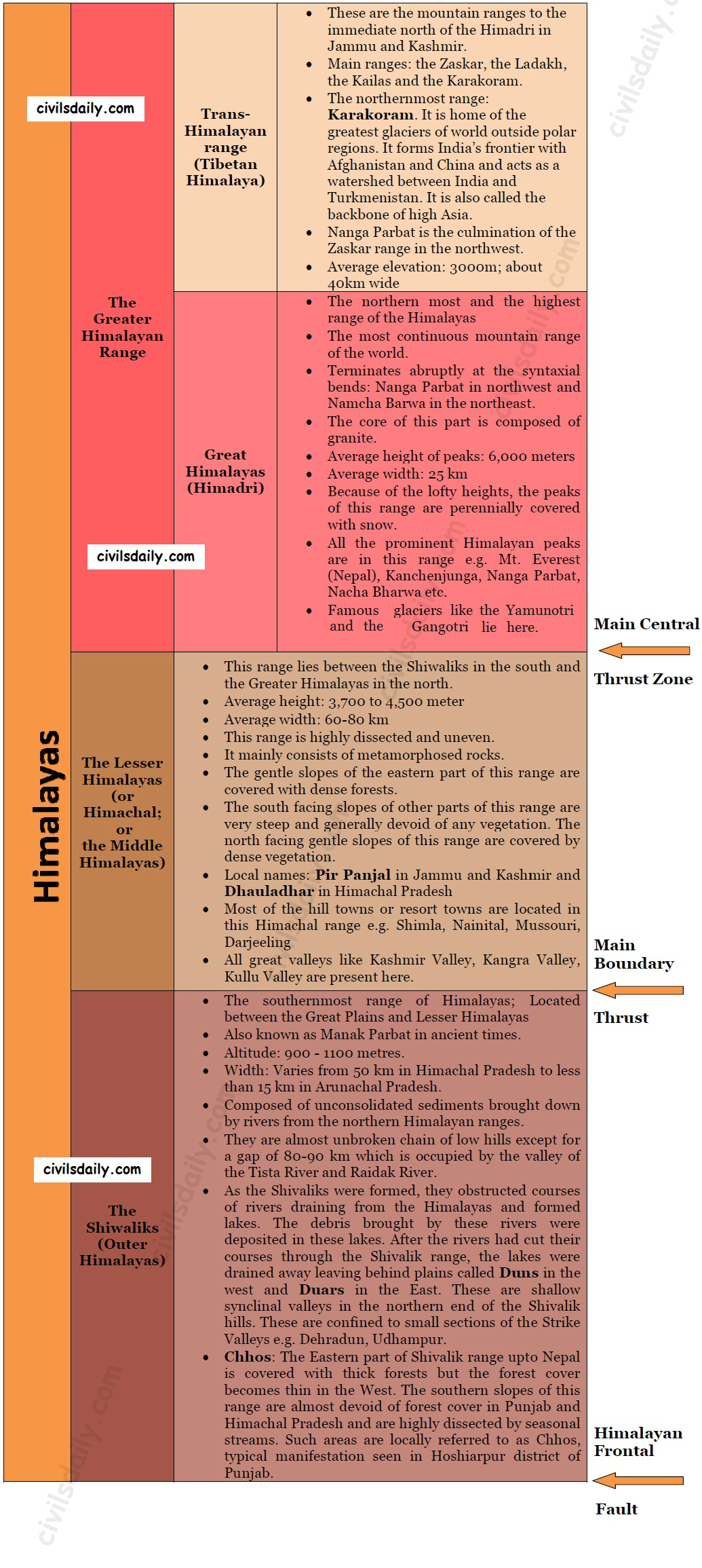
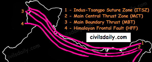
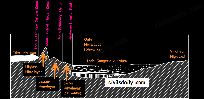
- Indus-Tsangpo Suture Zone: It represents a belt of tectonic compression caused by the underthrusting of the Indian shield/ plate against the Tibetan mass. It marks the boundary between Indian and Eurasian plates. The suture zone stretches from the North Western Himalayan syntaxis bordering the Nanga Parbat to the East as far as the Namche Barwa Mountain. Tha Karakoram range and the Ladakh plateau lie to the north of ITSZ and originally formed a part of the European plate.
- Main Central Thrust Zone: This separates the Higher Himalayas in the north from lesser Himalayas in the south. It has played an important role in the tectonic history of these mountains.
- Main Boundary Thrust: It is a reverse fault of great dimensions which extends all the way from Assam to Punjab and serves to separate the outer Himalayas from the lesser Himalayas.
- Himalayan Frontal Fault: It is a series of reverse faults that demarcates the boundary of the Shivalik from of the Himalayan province from the alluvial expanse of the Indo-Gangetic plains.

thanks sir
best explanation ever by any site , best diagrammatic explanation ,,,thank u team CD
clearly explained
Excellent explanation… thanks a lot