The geological structure of a country helps in understanding the types and character of rocks and slopes, the physical and chemical properties of soils, the availability of minerals, and the surface and underground water resources. But before we can study the geological structure of India, it is important that we understand what a geological time scale means:
The Geological Timescale
When did the dinosaurs get extinct? When did the birds first appear on earth? What about the beginning of life itself?
To answer these questions, geologists use a special timeline called the Geological Time Scale. It is a record of Earth’s Geologic history based on radiometric dating and the record of ancient life preserved in layers of rocks.
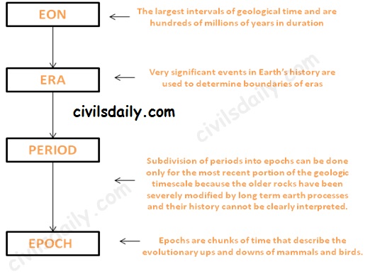
The geological timescale is broken up into larger and smaller subdivisions which help us understand how the various historical events fit together. These time intervals are not equal in length like the hours in a day. Instead, the time intervals are variable in length because geologic time is divided using significant events in the history of the Earth. The various intervals are:
Let’s watch a video to understand this division better:
The geological timescale thus looks like:
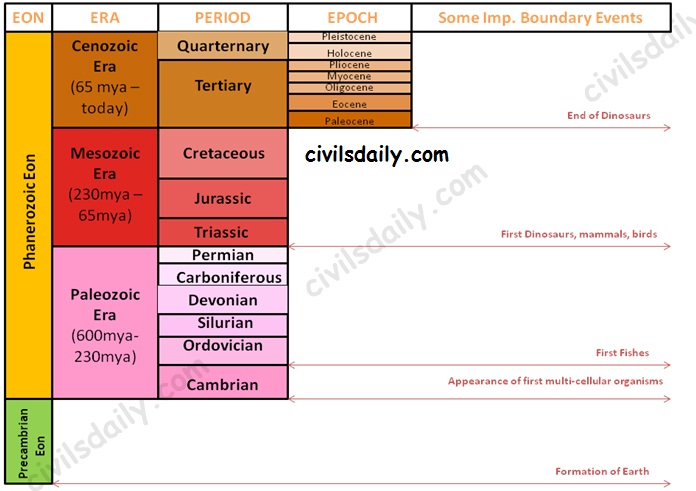
The Geological Timescale
Note: Due to lack of sufficient information about the Precambrian Eon, there is no subdivision into eras etc. At the same time, it is important to note that the Precambrian time constitutes about 86.7% of Earth’s history.
The Indian Geological History:
Major events in the geological history of India:
- Peninsular India was a part of the old landmass since the formation of the Earth’s Crust
- The upheaval of Himalayas in the tertiary period.
- Aggradational formation of the Indo-Gangetic plain during the Pleistocene period. It continues till today through sedimentation in the floodplains of the rivers and the lower part of the Gangetic plain.
Based on this complex and varied geological history, the Geological Survey of India has classified rock systems of the country into 4 major divisions:
Let us study the basic features of each of these:
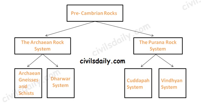
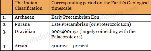
- The Archaean rock system (Early Pre-Cambrian)
The Archaean group of rocks consists of two systems-(a) Achaean granites and gneisses, and (b) Dharwarian sedimentary:
- Archaean Gneisses and Schists (pre 2500 million years)
- The Archean System contains the first formed rocks of the earth.
- The rocks are primarily gneisses and granites, having no marks of fossils.
- They often underlie the strata formed subsequently and the system is generally known as the basement complex or fundamental gneisses.
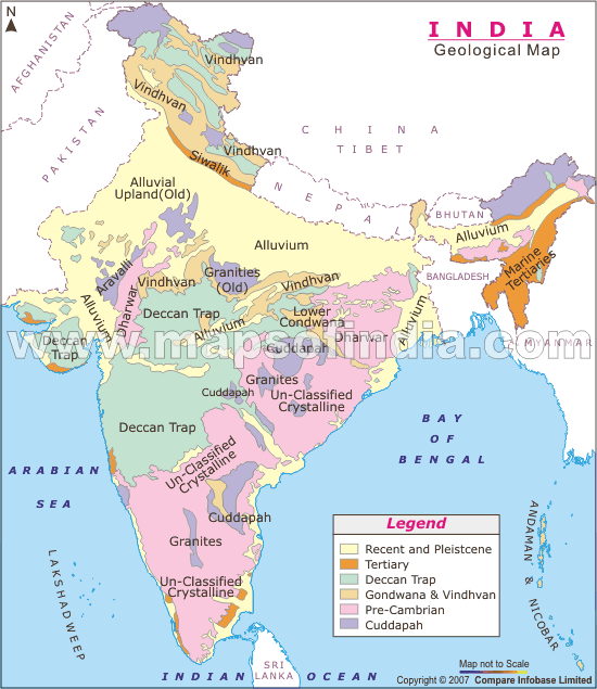
- The Archaean rocks cover two-thirds of the peninsular India. They also occur in roots of the mountain peaks all along the Greater Himalayas, trans-Himalayan ranges of Zaskar, Ladakh and Karakoram.
- Dharwar System (2500-1800 million years ago)
- The weathering of the Archaean rocks yielded the earliest sediments and formed the oldest sedimentary strata, the Dharwar system.
- These are found today in metamorphic forms and do not contain fossils.
- These rocks occur in scattered patches in parts of Karnataka, Tamil Nadu, central and eastern parts of Chotanagpur plateau, Meghalaya plateau, Aravalis, Himalayan region etc as shown on the map.
The Archaean rocks are economically the most important rocks because they possess valuable minerals like high-grade iron ore, manganese, copper, lead, gold, quartzite, slates, mica, etc.
1. The Purana Rock System (Late Pre-cambrian):
The Archaean gneiss and the Dharwar rocks underwent further erosion leading to the formation of the Purana Rock system.
The Purana rock system is further subdivided into (i) the Cuddapah and (ii) the Vindhyan
- The Cuddapah
- These rocks are generally without fossils
- These formations, named after the Cuddapah district in Andhra Pradesh are sedimentary metamorphic formations.
- These are found in Andhra Pradesh, southern Chhattisgarh, Odisha and along the main axis of Aravallis.
- The metallic content in ores of Cuddapah rocks is low and at places uneconomical for extraction.
- The Vindhyan
- This system derives its name from the Vindhyan mountains
- Consists of enormous sedimentary deposits. In some tracts, Vindhyan rocks are buried under the Deccan lava.
- It stretches from Sasaram in Bihar to Chittorgarh in Rajasthan with the exception of the central tract of Bundelkhand gneiss.
- The well-known diamond mines of Panna and Golconda lie in the Vindhayan region.
- This rock system is well known for red sandstone, sandstone, durable stones, ornamental stones, raw materials for lime, glass, cement and chemical industries.
2. The Dravidian Rock system (Cambrian to middle carboniferous)
- These formations do not occur in the peninsular plateau as it was above the sea level at that time but are found in continuous sequence in the Himalayas.
- They contain abundant fossils in them
- Coal formation started in the Carboniferous age. Carboniferous in geology means coal-bearing. [Most of the coal found in India is not of the Carboniferous period; High-quality coal of Great Lakes Region-USA, U.K and Ruhr region is Carboniferous coal].
3. The Aryan Rock system (Upper Carboniferous to recent)
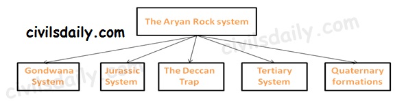
The Aryan Rock System
- The Gondwana System:
- The peninsula during the Upper Carboniferous period experienced crustal movements, which led to the formation of basin-shaped depressions. These depressions had countless terrestrial plants and animals, which were buried to from coal deposits in India known as the Gondwana Rocks.
- These rocks have also marks of climatic changes from arctic cold to tropical and desert conditions.
- These Rocks are found mainly in the Damodar, the Mahanadi and the Godavari valleys of the peninsula.
- Gondwana rocks contain nearly 98 percent of India’s coal reserves. Gondwana coal is much younger than the Carboniferous coal and hence its carbon content is low.
- Jurassic System:
- The marine transgression in the latter part of the Jurassic gave rise to thick series of shallow water deposits in Rajasthan and in Kuchchh.
- Coral limestone, sandstone, conglomerates and shales occur in Kuchchh.
- Another transgression on the east coast of the Peninsula is found between Guntur and Rajahmundry.
- The Deccan Trap:
- Towards the end of the Mesozoic era, intensive volcanic activity took place, which flooded with lava vast areas of Maharashtra and other parts of the Deccan known as the Deccan traps.
- The volcanic rocks contain some thin fossiliferous sedimentary layers found between the lava flows. This indicates that the lava flows was not continuous. The volcanic activity led to two great events
1. Breakup of the Gondwanaland masses
2. Uplift of the Himalayas out of the Tethys Sea. - Present Deccan Trap covers about 5 lakh sq km mainly in parts of Kuchchh, Saurashtra, Maharashtra, the Malwa plateau and northern Karnataka.
- The weathering of these rocks for a long time has given birth to black cotton soil known as ‘regur’.
- Tertiary System
- Eocene to Pliocene about 60 to 7 million years ago.
- The tertiary is the most significant period in India’s geological history because the Himalayas were born and India’s present form came into being in this period.
- The Pleistocene and recent formations (The quaternary period)
- Quaternary is the name proposed for very recent deposits, which contains fossils of species with living representatives
- These include Satluj-Ganga-Brahmaputra plains and Karewa formations of the Kashmir valley.
Geological Divisions of India:
Geologic divisions are marked by geologists as regions of similar rocks, structures and geologic history [Recall the brief geological history of India discussed above]. Geologically, India is divided into 3 major regions (also called the Triple Tectonic division):
- The Peninsular Plateau region – It also includes the Shillong Plateau and the Kutchch Kathiawar region (Outliers)
- The Extra-peninsular region – the mountainous region of Himalayas.
- The Himalayas are young, weak and flexible in their geological structure, unlike the rigid and stable Peninsular Block.
- Consequently, they are still subjected to the interplay of exogenic and endogenic forces, resulting in the development of faults, folds and thrust plains.
- These mountains are tectonic in origin, dissected by fast-flowing rivers which are in their youthful stage.
- Various landforms like gorges, V-shaped valleys, rapids, waterfalls, etc. are indicative of this stage.
- The Indo-Gangetic Plain between the above two.
In addition to these, there are 2 minor divisions:
- The Coastal Plains (Eastern and western)
- The Islands (Lakshadweep and Andaman and Nicobar)
Physiographic divisions of India
Physiography deals with the study of surface features. This includes the landforms (mountains and valleys, their shape and steepness), the way rivers flow across the land, and the way in which the land erodes. Geographers recognize physiographic divisions based on the shape of the land.
There is a close relationship between India’s physiographic and geologic divisions as geology affects the way the land erodes.
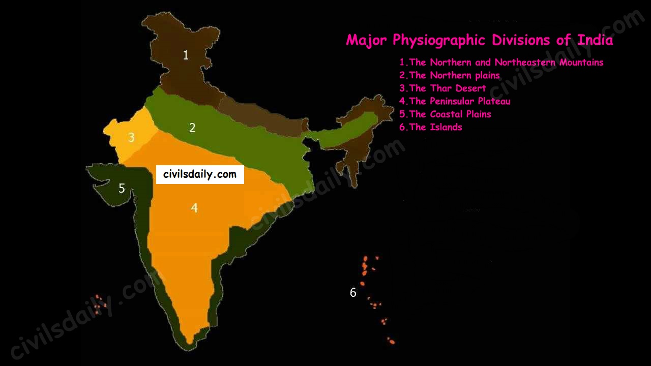
The Indian landmass can be divided into the following broad physiographic units:
- The Northern and Northeastern Mountains
- The Northern plains
- The Thar Desert
- The Peninsular Plateau
- The Coastal Plains
- The Islands
In the next articles, we will study each of these divisions in detail. [For the next article on the Himalayan mountains, click here]
But before we proceed to the next article, let’s look at the following question from a past UPSC examination:
Prelims:
1997:
Question: Match List I with List II and select the correct answer using the codes given below the lists:
List I List II
A) Deccan Traps 1) Late cenozoic
B) Western Ghats 2) Pre-cambrian
C) Aravalli 3) Cretaceous Eocene
D) Narmada-Tapi alluvial deposits 4) Cambrian
5) Pleistocene
a) A-3 B-5 C-1 D-4
b) A-3 B-1 C-2 D-5
c) A-2 B-1 C-3 D-4
d) A-1 B-4 C-2 D-5
Ans. b

Comments
11 responses to “The Geological Structure of India”
Thank you for this. Extremely informative.
Pretty good article. Would like to know the source for further detailed study.. thank you
is it enough for CSE ?
Indeed yes. It is more than enough.
hey very useful
recently i join your app its amazing.
A great thank to u and your team.
Hi Manisha
Thanks a lot for the kind words. We look forward to serving aspirants like you in your journey for excellence in civil services examinations.
very nice
Nice notes.
Sir, Side panel on this site is not visible now (only black colored space). Kindly fix.
EERIE PEEP (Eon, era, period, epoch)
Precambrian is divided into hadean (no life), archean (photosynthesis), proterozoic (single celled org).
Cambrian(sudden mass multi cellular org) in phanerozoic(=visible life). Hence this Cambrian period is imp