Why in the News?
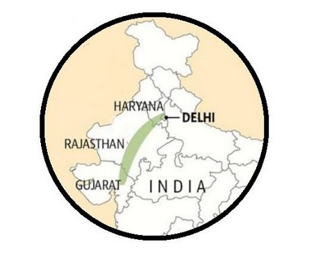
The Supreme Court has reserved its verdict on the definition of the Aravalli Hills and Ranges, a critical environmental issue impacting Delhi, Haryana, Rajasthan, and Gujarat.
About the Aravallis:
|
About the Aravalli Case: Quick Backgrounder
- Supreme Court Review: The Court is deciding on a uniform, legally enforceable definition of the Aravalli Hills and Ranges across Delhi, Haryana, Rajasthan, and Gujarat.
- Case Origin: Stems from the long-running M.C. Mehta vs Union of India (2008) matter on illegal mining, encroachment, and ecological degradation in the Aravallis.
- Judgment: The Court held Aravalli lands to be forest areas under the Forest (Conservation) Act, 1980, restricting non-forest activities.
- Existing Legal Protection: Notifications under the Punjab Land Preservation Act, 1900 were upheld for safeguarding ecologically sensitive land.
- Expert Committee (2024): SC directed MoEF&CC to set up a panel to develop a scientific definition for consistent protection across states.
Proposed Legal Definitions of Aravalli Hills and Ranges
- Purpose: Ensures clear identification to regulate mining, prevent encroachment, and protect biodiversity.
- Aravalli Hill: A landform with minimum 100 m elevation above local relief, measured from the lowest encircling contour, including slopes and ridges.
- Aravalli Range: Formed when two or more Aravalli Hills lie within 500 metres of each other, covering hillocks, slopes, and valleys.
| [UPSC 2023] Consider the following statements:
1. Amarkantak Hills are at the confluence of Vindhya and Sahyadri Ranges. 2. Biligirirangan Hills constitute the easternmost part of Satpura Range. 3. Seshachalam Hills constitute the southernmost part of Western Ghats How many of the statements given above are correct? Options: (a) Only one (b) Only two (c) All three (d) None* |