As a part of revision for Prelims 2018, Here’s a Factoid to brush up your concepts
Key words related to History : Gomastha
Dynasty/era : Mughal period
Meaning : 1.Gomastha described an Indian agent of the British East India Company employed in the Company’s colonies, to sign bonds, usually compellingly, by local weavers and artisans to deliver goods to the Company. The prices of the goods were fixed by the gomasthas. 2.The goods were exported by the Company to Europe and America.Gomastha may also be described as ‘a paid manager of the private trader’s concerns’, who claimed ‘hardly any share in the profit and loss of his employer’s business’
Key words related to History: Ibadat Khana
Dynasty/era : Mughal period
Meaning : The Ibādat Khāna was a meeting house built in 1575 CE by the Mughal Emperor Akbar at Fatehpur Sikri to gather spiritual leaders of different religious grounds so as to conduct a discussion on the teachings of the respective religious leaders
The Peninsular drainage system is older than the Himalayan one. This is evident from the broad, largely-graded shallow valleys, and the maturity of the rivers.
Evolution: Three major geological events in the distant past have shaped the present drainage systems of Peninsular India:
Subsidence of the western flank of the Peninsula leading to its submergence below the sea during the early tertiary period. Generally, it has disturbed the symmetrical plan of the river on either side of the original watershed and left just the upper parts of west flowing rivers above the sea level.
Upheaval of the Himalayas when the northern flank of the Peninsular block was subjected to subsidence and the consequent trough faulting. The Narmada and The Tapi flow in trough faults and fill the original cracks with their detritus materials. Hence, there is a lack of alluvial and deltaic deposits in these rivers.
Slight tilting of the Peninsular block from north-west to the southeastern direction gave orientation to the entire drainage system towards the Bay of Bengal during the same period.
River-Systems:
The peninsular river system can be categorised into the following sections:
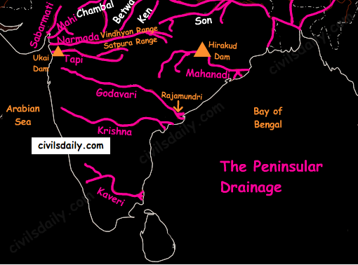
The East flowing rivers – the Mahanadi, the Godavari, the Krishna and the Cauvery flow eastwards and drain into the Bay of Bengal. These rivers make deltas at their mouths.
The West flowingrivers:
Narmada and Tapi along with other small rivers originating from the Western Ghats and falling in the Arabian Sea form estuaries in place of deltas. This is due to the fact that these rivers, especially Narmada and Tapi, flow through hard rocks and are not able to form distributaries before they enter the sea.
Although these west flowing rivers of Sahyadri form only about 3% of the areal extent of basins of India, they contain about 18% of the country’s water resources.
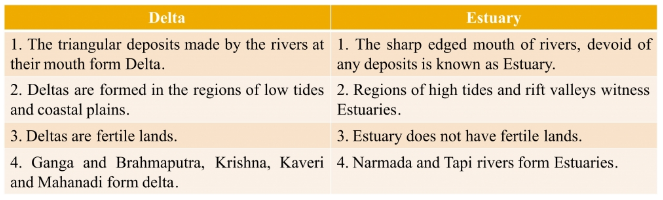
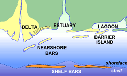
Wondering what is the difference between a delta and an estuary? Let’s see:
The Western Ghats running close to the western coast act as a water divide between the major Peninsular Rivers discharging their water in the Bay of Bengal and the small rivulets joining the Arabian Sea.
The Chambal, the Sind, the Betwa, the Ken, the Son, originating in the northern part of the Peninsula belong to the Ganga river system.
The Peninsular rivers are characterized by fixed courses, absence of meanders and non-perennial flow of water. The Narmada and the Tapi which flow through the rift valley are, however, exceptions.
The Peninsular Drainage
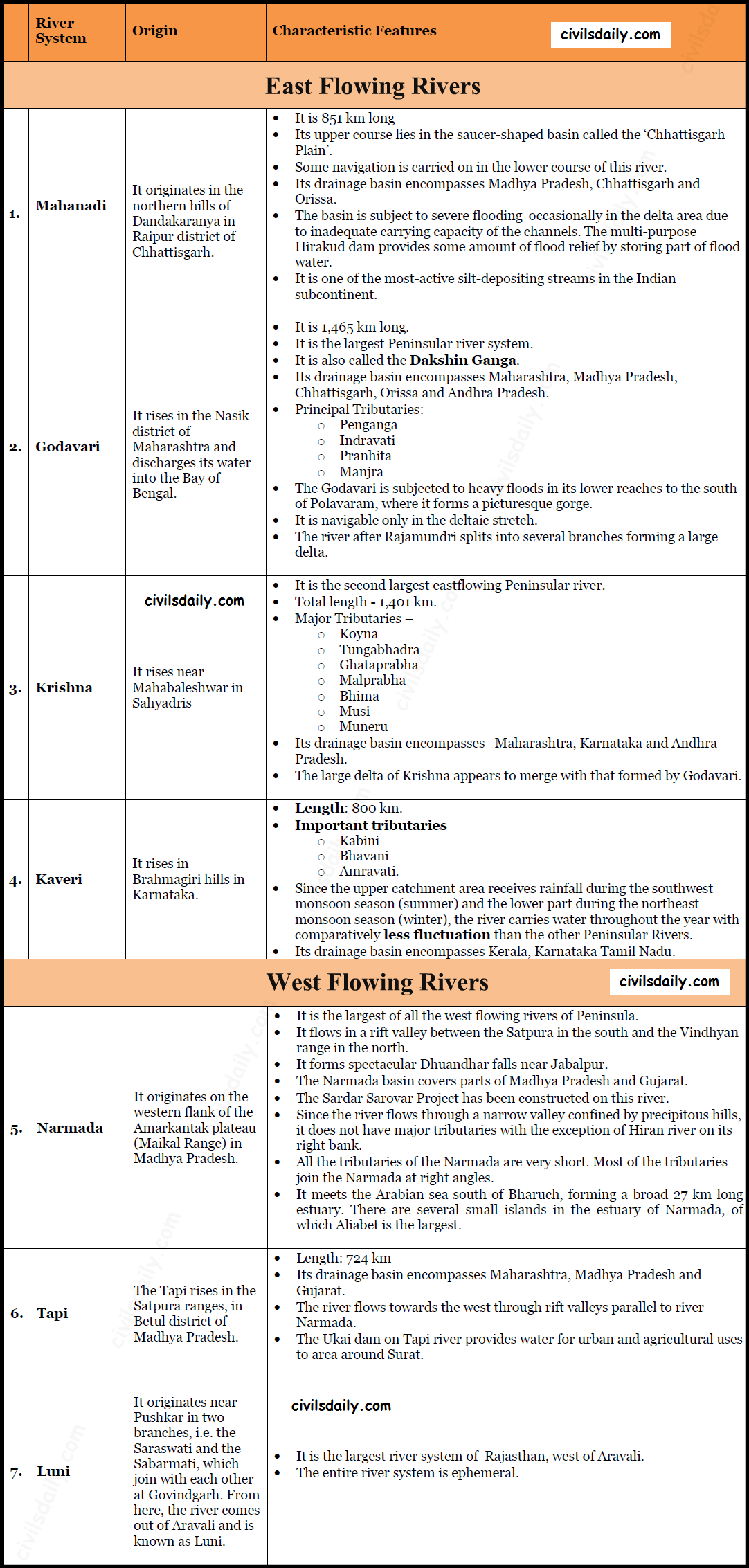
A brief account of the major Peninsular river systems is given below:
Major Peninsular River Systems
Smaller rivers flowing Towards the West:
The rivers flowing towards the Arabian Sea have short courses ( Because their origins lie closer to the sea, and the Western Ghats act as a water divide). Several of these small rivers are important for the production of hydroelectricity because of steep slopes and waterfalls.
Gujarat:
The Shetruniji – It rises near Dalkahwa in Amreli district.
The Bhadra – It originates near Aniali village in Rajkot district.
The Dhadhar rises near Ghantar village in Panchmahal district.
Sabarmati
Mahi
Maharashtra:
The Vaitarna rises from the Trimbak hills in Nasik district
The Kalinadi rises from Belgaum district and falls in the Karwar Bay.
The source of Bedti river lies in Hubli Dharwar and traverses a course of 161 km.
The Sharavati is another important river in Karnataka flowing towards the west. The Sharavati originates in Shimoga district of Karnataka and drains a catchment area of 2,209 sq. km. The famous Jog or Gersoppa Falls (289m) made by Sharavati river are the highest untiered waterfalls in India.
Goa:
Mandovi
Juari
Kerala:
Bharathapuzha – It is the largest river of Kerala. It is also known as Ponnani. It originates from Annamalai hills and flows into the Arabian Sea at a place called Ponnani.
The Periyar – It is the longest and the second largest river of Kerala. [Largeness of a river is related to its basin size and the volume of water flowing in the river. At the same time when we say that a river is the longest, it means that we are referring to its geographical length]
The Pamba river – It falls in the Vembanad lake.
Small Rivers Flowing towards the East:
There are small rivers which join the Bay of Bengal, though small, these are important in their own right.
As a part of revision for Prelims 2018, Here’s a Factoid to brush up your concepts
#1. Name : Block-III version of Brahmos cruise missile
Defence Forces : Army
Module Type : Missiles
Brief Intro : Block III had advanced guidance and upgraded software, incorporating high manoeuvres at multiple points and steep dive from high altitude. The steep dive capability of the Block III enables it to hit targets hidden behind a mountain range. It will be deployed in Arunachal Pradesh. It can engage ground targets from an altitude as low as 10 meters for surgical strikes with out any collateral damage. It is capable of being launched from multiple platforms like submarines, ships, aircraft and land based Mobile Autonomous Launchers (MAL). Range: 450 Km (to be upgraded to 600 Km)
#2. Name : Agni III
Defence Forces : Army
Module Type : Missiles
Brief Intro : Agni-III is an intermediate-range ballistic missile developed by India as the successor to Agni-II. It has a range of 3,500 km- 5,000 km, and is capable of engaging targets deep inside neighbouring countries. The missile’s Circular error probable (CEP) is within 40 meters range, which makes it the most sophisticated and accurate ballistic missile of its range class in the world.
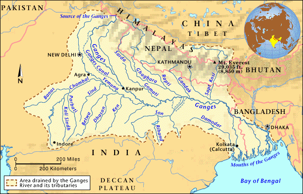
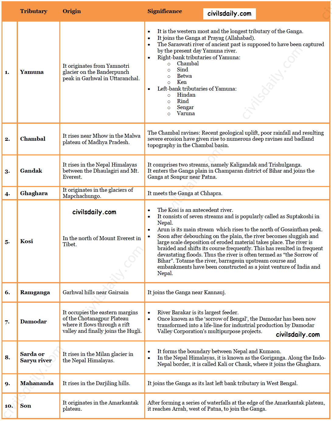
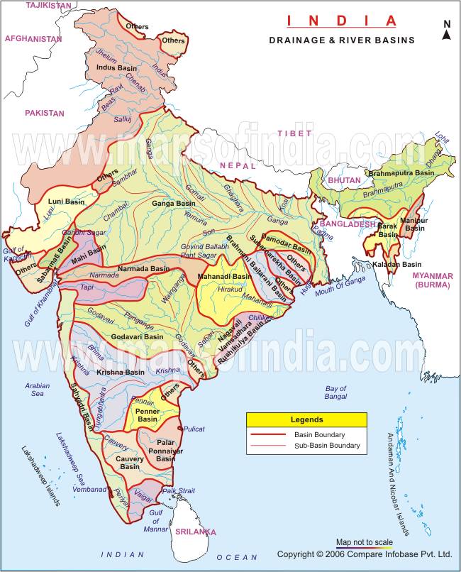
The Ganga river system is the largest in India having a number of perennial and non-perennial rivers originating in the Himalayas in the north and the Peninsula in the south, respectively. It accounts for 26.3% of the geographical area of the country and is shared by ten states.
Ambala is located on the water divide between Indus and Ganga.
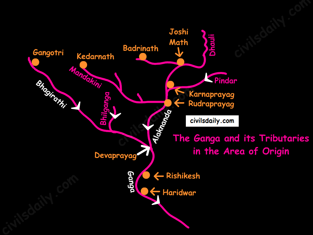
Origin: It rises in the Gangotri glacier near Gaumukh in the Uttarkashi district of Uttaranchal. Here, it is known as the Bhagirathi. At Devprayag, the Bhagirathi meets the Alaknanda; hereafter, it is known as the Ganga.
The Ganga and its Tributaries in the Area of Origin
The river-course:
The Ganga enters the plains at Haridwar.
From here, it flows first to the south, then to the south-east direction to reach Allahabad. Here it is joined by the Yamuna.
Further, near Rajmahal hills, Ganga turns south-east and bifurcates at Farakka into Bhagirathi – Hugli in West Bengal and as the Padma in Bangladesh.
The river finally discharges itself into the Bay of Bengal near the Sagar Island.
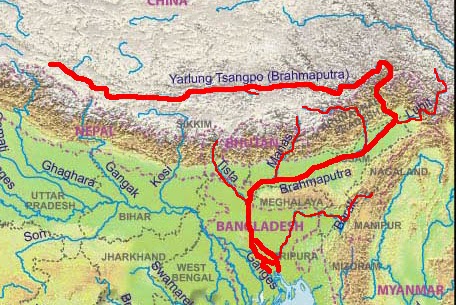
Origin: The Brahmaputra has its origin in the Chemayungdung glacier of the Kailash range near the Mansarovar lake. Mariam La separates the source of the Brahmaputra from the Manasarovar Lake.
The river-course:
Most of the course of the Brahmaputra lies in Tibet, popularly known as Tsangpo. It flows eastwards parallel to the Himalayas. It receives a large number of tributaries in Tibet. The first major tributary is the Raga Tsangpo meeting the Tsangpo near Lhatse Dzong.
After reaching Namcha Barwa, it takes a “U” turn (also known as Hair Pin turn) and enters India west of Sadiya town in Arunachal Pradesh through the deep Dihang or Siang gorge of Himalayas. Here initially it is called as Siang and then as Dihang.
It is joined by Dibang, Lohit, Kenula and many other tributaries and finally forms the Brahmaputra in Assam.
It then enters into Bangladesh near Dhubri and flows southward. In Bangladesh, the Tista joins it on its right bank from where the river is known as the Jamuna. [Note: The Tista was a tributary of the Ganga prior to the floods of 1787 after which it diverted its course eastwards to join the Brahmaputra.]
The Jamuna and Ganga confluence at Goalundo and afterwards are called as the Padma. Further south, Padma is joined by Meghna (Barak river in India) and thence onward it is known as Meghna to finally merge in the Bay of Bengal.
It is called:
The Tsangpo in Tibet ( Tsangpo = ‘the purifier.’)
The Brahmaputra in India
The Jamuna in Bangladesh
Major left bank tributaries:
Burhi Dihing,
Dhansari (South)
Kalang
Major right bank tributaries:
Subansiri ( It has its origin in Tibet and is an antecedent river.)
Kameng
Manas
Sankosh
Characteristic Features:
River Brahmaputra is a little longer than the river Indus.
It forms a spectacular Grand Canyon – like canyon in Tibet.
The river is nearly 16 km wide at Dibrugarh and forms many islands, the most important of which is Majuli. Majuli is the world’s largest riverine island and India’s first island district.
The Brahmaputra has a braided channel. It carries a lot of silt and there is excessive meandering.
The Brahmaputra is well-known for floods, channel shifting and bank erosion. This is due to the fact that most of its tributaries are large, and bring large quantity of sediments owing to heavy rainfall in its catchment area.
As a part of revision for Prelims 2018, Here’s a Factoid to brush up your concepts
#1. Name of the scheme : Vittiya Saksharata Abhiyan (VISAKA)
Objectives : To make people aware about cashless economic system.
Salient Features : Financial literacy
Nodal Ministry : Ministry for Human Resource Development (MHRD)
#2. Name of the scheme : Pradhan Mantri Gramin Digital Saksharta Abhiyan(PMDISHA)
Objectives : To make 6 crore rural households digitally literate
Salient Features : 1.It is expected to be one of the largest digital literacy programmes in the world. 2.Under the scheme, 25 lakh candidates will be trained in the FY 2016-17; 275 lakh in the FY 2017-18; and 300 lakh in the FY 2018-19. 3.To ensure equitable geographical reach, each of the 250,000 Gram Panchayats would be expected to register an average of 200-300 candidates.
Nodal Ministry : The Ministry of Electronics and Information Technology (MeitY)
As a part of revision for Prelims 2018, Here’s a Factoid to brush up your concepts
Name of the scheme: National Skill Development Mission
Objectives : NSDM will provide a strong institutional framework at the Centre and States for implementation of skilling activities in the country.
Salient Features : The Mission will have a three-tiered, high powered decision making structure: 1. At its apex, the Mission’s Governing Council, chaired by the Prime Minister, will provide overall guidance and policy direction. 2. The Steering Committee, chaired by Minister in Charge of Skill Development, will review the Mission’s activities in line with the direction set by the Governing Council. 3. The Mission Directorate, with Secretary, Skill Development as Mission Director, will ensure implementation, coordination and convergence of skilling activities across Central Ministries/Departments and State Governments.
Nodal Ministry : Ministry of Skill Development and Entrepreneurship
Name of the scheme : Nirbhaya Fund
Objectives : -Nirbhaya Fund is an Indian rupee 10 billion corpus announced by Government of India in its 2013 Union Budget. -According to the then Finance Minister P. Chidambaram, this fund is expected to support initiatives by the government and NGOs working towards protecting the dignity and ensuring safety of women in India. -Nirbhaya (fearless) was the pseudonym given to the 2012 Delhi gang rape victim to hide her actual identity.
Nodal Ministry: Earlier Ministry of Home Ministry, Now Ministry of Women & Child
1. On the basis of discharge of water – the Arabian Sea drainage and the Bay of Bengal drainage:
On the basis of discharge of water (orientations to the sea), the drainage system of India may be grouped into:
the Arabian Sea drainage
the Bay of Bengal drainage
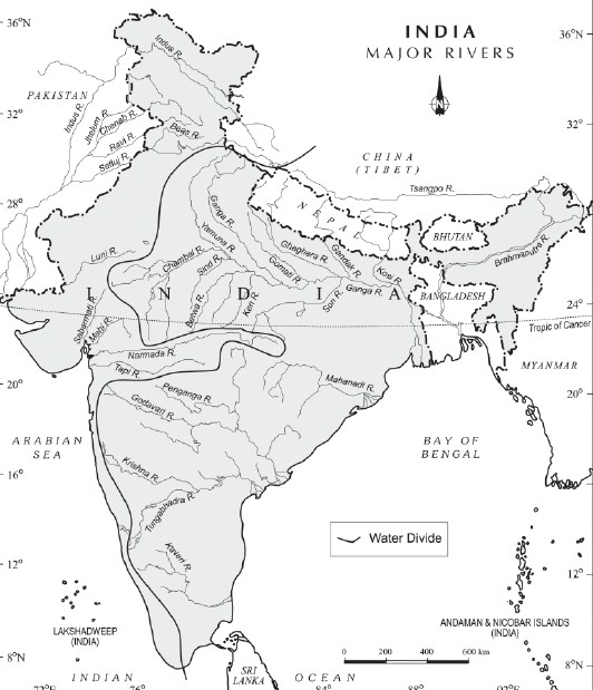
They are separated from each other by the Delhi ridge, the Aravalis and the Sahyadris (water divide is shown by a line in the following map).
Source: NCERT
Nearly 77 percent of the drainage area consisting of the Ganga, the Brahmaputra, the Mahanadi, the Krishna, etc. is oriented towards the Bay of Bengal while 23 percent comprising the Indus, the Narmada, the Tapi, the Mahi and the Periyar systems discharge their waters in the Arabian Sea.
1. Rivers of the inland drainage basin (endorheic basin): When a river does not reach the sea but disappears into the sand, such a region is called an area of inland drainage. Inland drainage streams are ephemeral streams (short-lived). E.g.:
The Ghaggar river in Haryana, which is supposed to be remnant of the proverbial ancient Saraswati river, gets lost in dry sands near Hanumangarh in Rajasthan.
The Luni river in Rajasthan originates near Ajmer and after flowing through Thar desert gets lost in the Rann of Kutch.
The Aksai Chin region in Ladakh too has some inland drainage.
2. On the basis of the size of the watershed:
Major river basins – with more than 20,000 sq. km of catchment area. It includes 14 drainage basins such as the Ganga, the Brahmaputra, the Krishna, the Tapi, the Narmada, the Mahi, the Pennar, the Sabarmati, the Barak, etc.
Medium river basins – with catchment area between 2,000-20,000 sq. km incorporating 44 river basins such as the Kalindi, the Periyar, the Meghna, etc.
Minor river basins – with catchment area of less than 2,000 sq. Km, these include 55 river basins.
3. On the basis of the mode of origin, nature and characteristics:
The Himalayan drainage, and
The Peninsular drainage.
There is no clear-cut line of demarcation between these two drainage systems, as many of the peninsular rivers like the Chambal, Betwa, Sind, Ken and Son are much older in age and origin than the Himalayan rivers.
Let’s follow this line of classification and look at the drainage system of India in detail. We begin with the Himalayan drainage.
The Himalayan Drainage system:
It consists of the rivers originating in the Himalayan and trans-Himalayan region. It further consists of three river systems namely:
the Ganga,
the Indus, and
the Brahmaputra river systems.
Since these are fed both by the melting of snow and precipitation, rivers of this system are perennial.
The various geographical features made by the Himalayan rivers are:
In upper reaches (Youthful stage): Gorges, V-shaped valleys, rapids, waterfalls, truncated spurs etc.
In plain areas or middle part (Mature stage): While entering the plains, they form depositional features like flat valleys, ox-bow lakes, flood plains, braided channels, and deltas near the river mouth. Over the plains, they display a strong meandering tendency and shift their courses frequently.
Evolution of the Himalayan Drainage System:
There is a difference of opinion about the evolution of the Himalayan Rivers. However, geologists believe that:
A mighty river called Shiwalik or Indo-Brahma traversed the entire longitudinal extent of the Himalaya from Assam to Punjab and onwards to Sind, and finally discharged into the Gulf of Sind near lower Punjab during the Miocene period some 5-24 million years ago.
Evidences: The remarkable continuity of the Shiwalik and its lacustrine origin and alluvial deposits consisting of sands, silt, clay, boulders and conglomerates support this viewpoint.
It is opined that in due course of time Indo–Brahma river was dismembered into three main drainage systems:
the Indus and its five tributaries in the western part;
the Ganga and its Himalayan tributaries in the central part; and
the stretch of the Brahmaputra in Assam and its Himalayan tributaries in the eastern part.
The dismemberment was probably due to the Pleistocene upheaval in the western Himalayas, including the uplift of the Potwar Plateau (Delhi Ridge), which acted as the water divide between the Indus and Ganga drainage systems.
Likewise, the downthrusting of the Malda gap area between the Rajmahal hills and the Meghalaya plateau during the mid-pleistocene period, diverted the Ganga and the Brahmaputra systems to flow towards the Bay of Bengal.
Let’s take up the three major river systems of the Himalayan drainage individually:
1. The Indus River System
It is one of the largest river basins of the world. A little over one-third of the Indus basin is located in India; in the states of Jammu & Kashmir, Himachal Pradesh and Punjab. The rest of the portion is in Pakistan.
The Indus also known as the Sindhu, is the westernmost of the Himalayan rivers in India.
Origin: It originates from a glacier near Bokhar Chu in the Kailash Mountain range (Tibetan region). In Tibet, it is known as ‘Singi Khamban; or Lion’s mouth.
The river-course:
The Indus cuts through Himalayas and enters India near Damchok.
flows in India only through the Leh district in Jammu and Kashmir.
It enters into Pakistan near Chillar in the Dardistan region through a deep gorge near the hair-pin bend of Nanga Parbat.
It finally discharges into the Arabian Sea, east of Karachi.
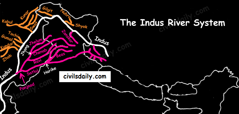
The right-bank tributaries of Indus:
Shyok
Gilgit
Hunza
Nubra
Kabul
Khurram
Tochi
Gomal
Sangar
Kunar
The left-bank tributaries of Indus:
Zaskar
‘Panjnad’ joins Indus a little above Mithankot). The Panjnad is the name given to the five rivers of Punjab, namely:
Satluj
Beas
Ravi
Chenab
Jhelum
Chief Characteristics:
The Indus drains the largest number of glaciers of Himalayas, Ladakh, Zaskar, and Kailash.
The Indus plain has a very gentle slope.
Indus and its Tributaries
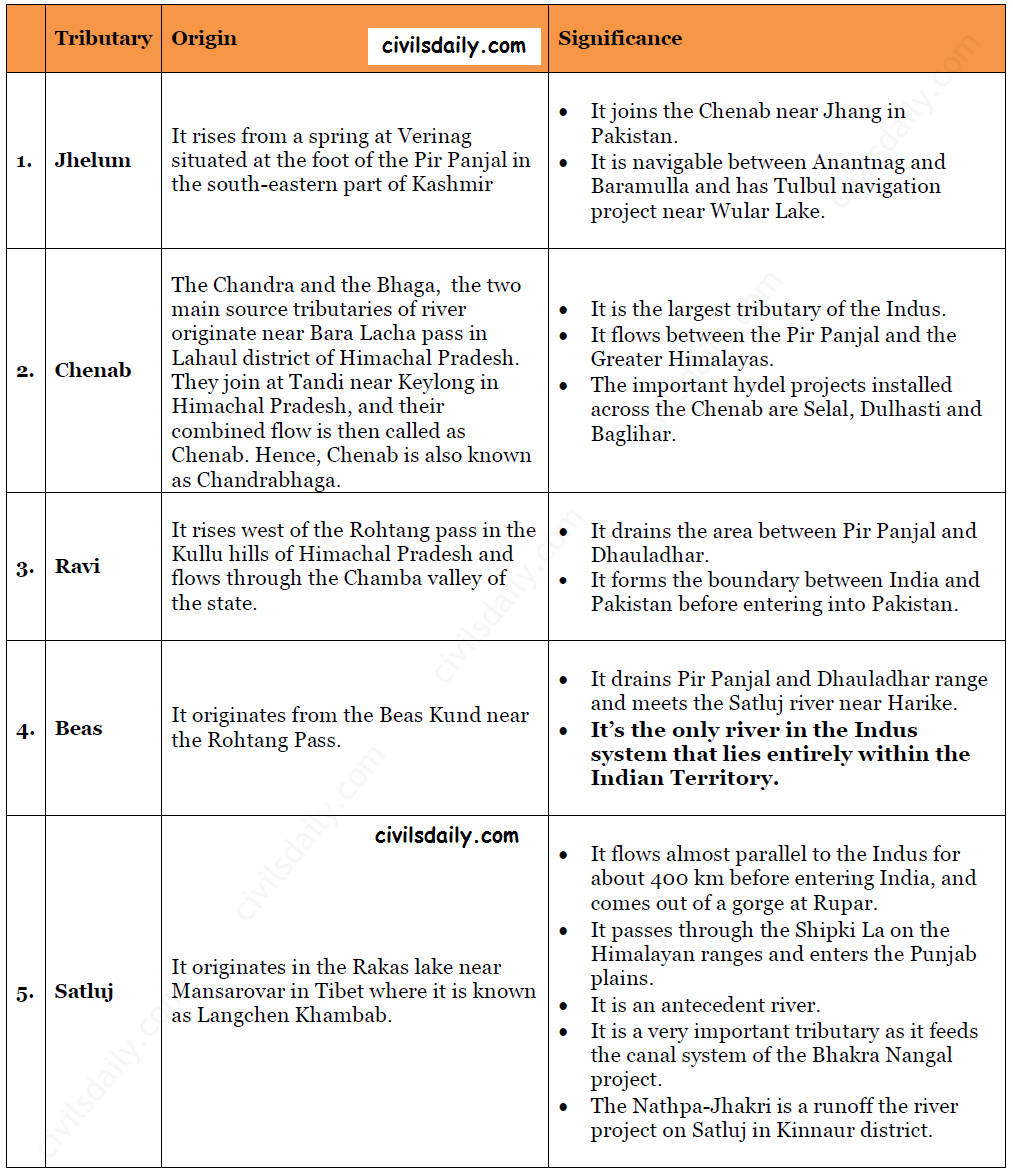
Let’s look at some important tributaries of Indus:
Important Tributaries of Indus and their Characteristic Features
The Indus water treaty: The waters of the Indus river system are shared by India and Pakistan according to the Indus Water Treaty signed between the two countries on 19th September 1960. According to this treaty, India can utilise only 20 percent of its total discharge of water. The Indus water treaty was recently in news. Remember why? Read here!
Ease of Doing Business is an index of World Bank which inter alia refers to the dispute resolution environment in a country which facilitates the investors in deciding for setting up of and operation of a business.
This index has been created by the World Bank Group and since 2002; it has been evaluating almost all the countries of the world.
A high ease of doing business ranking means the regulatory environment is more conducive to the starting and operation of the business.
India has emerged out as one among top ten improvers and for the first time ever, India has jumped 30 positions.
India reached 100th ranked country in terms of ‘Ease of Doing Business’ amongst 190 countries.
This manifests that India is fast adopting the best practices in regulatory framework for Ease of Doing Business at all fronts.
As a part of revision for Prelims 2018, Here’s a Factoid to brush up your concepts
Key words related to History : Parigraha
Dynasty/era : Mahavira period
Meaning : 1.Parigraha-parimana is one the 12 vratas or vows of a layperson in Jainism. Specifically, it is a vow to limit attachment to worldly possessions. 2.Unlike monks or ascetics who observe such vows more strictly, the layperson may make a vow to limit his or her attachment to certain possessions or a certain number of possessions, or they may vow to limit attachment for a specified period of time.
The flow of water through well-defined channels is known as ‘drainage’ and the network of such channels is called a ‘drainage system’.
Types of Drainage Patterns
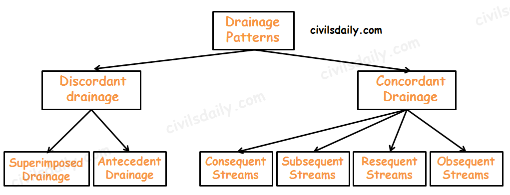
Discordant drainage
A pattern of drainage that bears no relation to the structure of the underlying rock. This may be because:
1. The drainage pattern developed on rock strata that have since been removed by erosion; a process known as superimposition. The drainage pattern thus developed is called superimposed drainage (or Epigenetic or Superinduced Drainage). Examples: The Damodar, the Subarnarekha, the Chambal, the Banas and the rivers flowing at the Rewa Plateau, rivers of eastern USA and southern France.
2. The drainage pattern was already present before a period of uplift and folding that formed the present structure. As the uplift took place, the rivers were able to cut down at approximately the same rate and so maintain their courses. This process is called antecedence and the drainage system thus developed is called antecedent drainage.
Many of the Himalayan rivers have antecedent origin i.e. these rivers existed even before the Himalayan ranges were uplifted. These rivers originate in the Tibetan side beyond the mountain ranges of Himalayas. The Indus, Satluj, Alaknanda, Gandak, Kosi, Brahmaputra all have an antecedent origin. Since these rivers are antecedent, they run transverse to the mountain ranges cutting deep V-shaped, steep-sided valleys (deep gorges).
Concordant Drainage (also called accordant drainage)
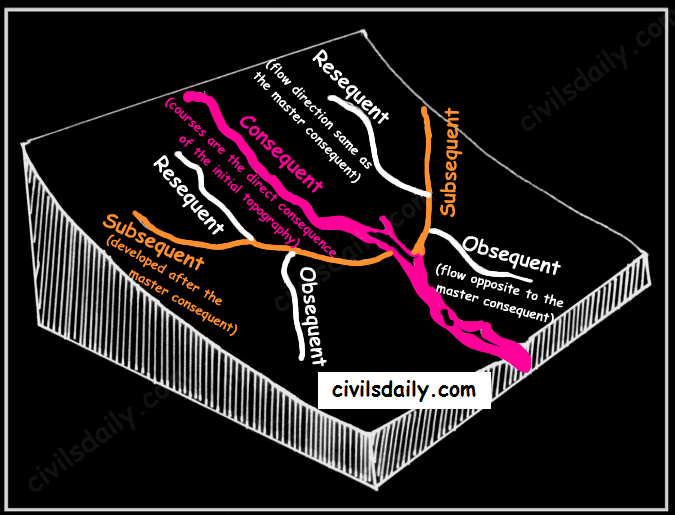
The pattern of drainage which arises from and closely follows the trends of the underlying strata is called concordant drainage.
Consequent Streams: Those streams whose courses are the direct consequence of the initial topography are called consequent streams.
Subsequent Streams: These are developed after the master consequent.
Obsequent streams: These flow in opposite direction to the master consequent.
Resequent Streams: A resequent stream flows in the same direction as that of the initial consequent stream, but which develops in response to a new base level formed due to inversion of relief.
Concordant Drainage Patterns
Drainage pattern:
Drainage pattern refers to a design which a river and its tributaries form together from its source to its mouth. The drainage pattern of an area is the outcome of:
The geological time period,
Nature and structure of rocks,
Topography,
Slope,
Amount of water flowing, and
The periodicity of the flow.
Some Important Drainage Patterns:
A combination of several patterns may be found in the same drainage basin.
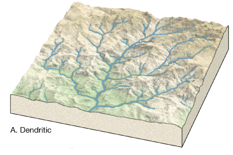
1. Dendritic: The dendritic pattern develops where the river channel follows the slope of the terrain. The drainage pattern resembling the branches of a tree is known as “dendritic” the examples of which are the rivers of northern plain. It is the most common stream pattern. A dendritic pattern develops in a terrain which has uniform lithology, and where faulting and jointing are insignificant.
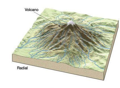
2. Radial: The radial pattern develops when streams flow in different directions from a central peak or a dome-like structure. E.g. the rivers like the Narmada, Son and Mahanadi originating from Maikal Hills flow in different directions and are good examples of a radial pattern.
Radial drainage patterns are also found/in the Girnar Hills (Kathiwar, Gujarat), and Mikir Hills of Assam.
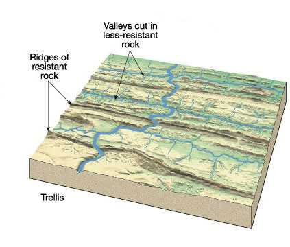
3. Trellis: When the primary tributaries of rivers flow parallel to each other and secondary tributaries join them at right angles, the pattern is known as ‘trellis’. A trellis drainage pattern develops where hard and soft rocks lie parallel to each other. For example, rivers in the upper part of the Himalayan region and in the old folded mountains of the Singhbhum (Chotanagpur Plateau) have drainage of trellis pattern. The trellis drainage pattern can also be seen in the Appalachian region of the U.S.A., where hard and soft rocks occur in parallel bands.
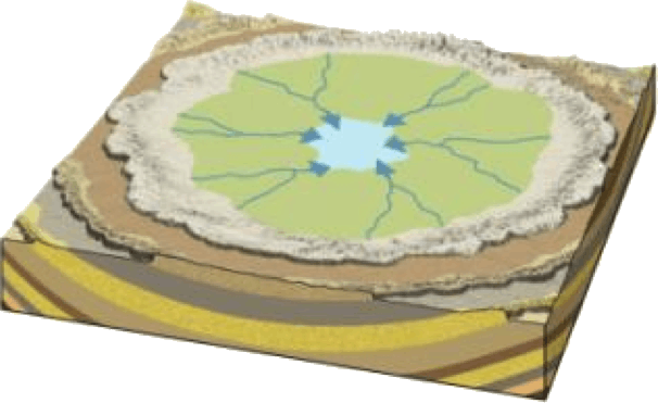
4. Centripetal: When the rivers discharge their waters from all directions in a lake or depression, the pattern is known as ‘centripetal’. This drainage pattern is also called endorheic drainage. For example, Loktak lake in Manipur.
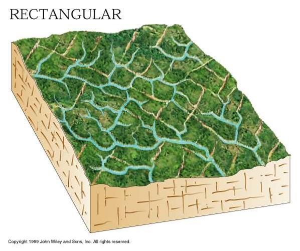
5. Rectangular: In this drainage, both the main stream and its tributaries show right-angled bends. A rectangular drainage pattern develops on a strongly jointed rocky terrain. It differs from trellis pattern drainage, since it is more irregular and its tributary streams are not as long or as parallel as in trellis drainage. Example: Colorado river (USA), streams found is the Vindhyan Mountains of India.
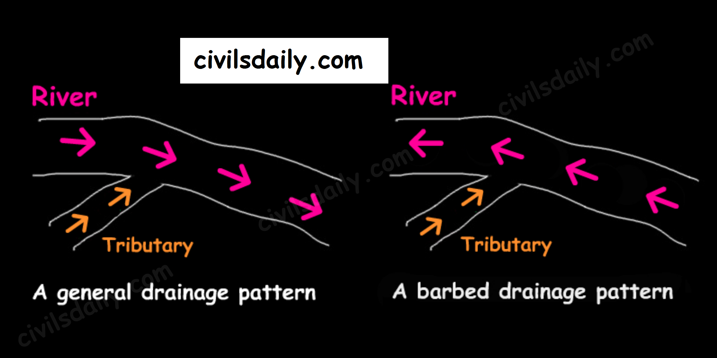
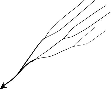
6. Barbed: If you look at the way that tributaries empty into larger rivers, you will notice that most of them flow in the same direction as the rivers they empty into. But quite a large number flow the other way. In fact, you will find stretches of some rivers where every tributary empties into the river in the “wrong” direction! Such an occurrence is known as a barbed drainage pattern.
Most barbed drainage patterns are the result of river-capture which reverses the direction of flow. However, the tributary channels continue to flow in their original direction.
The Arun River (Nepal), a tributary of the Kosi is an interesting example of barbed drainage pattern.
A Barbed Drainage Pattern
7. Annular: Annular pattern represents that part of a drainage pattern in which the subsequent streams follow the curving or arcuate courses before joining the consequent stream. These results from a partial adaptation to an underground circular structure i.e. batholiths. This is not a very common drainage pattern in India. Some examples of this are however found in Pithoragarh (Uttarakhand), Nilgiri Hills in Tamil Nadu and Kerala.
8. Parallel drainage: The drainage pattern in which the rivers flow almost parallel to each other is known as parallel drainage. The small and swift rivers originating in the Western Ghats and discharging their water into the Arabian Sea provide a good example of parallel drainage pattern in India.
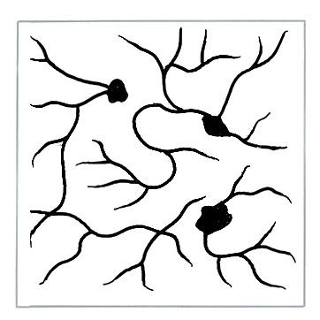
9. Deranged pattern: This is an uncoordinated pattern of drainage characteristic of a region recently vacated by an ice-sheet. The picture is one of numerous water courses, lakes and marshes; some inter-connected and some in local drainage basins of their own. This type of drainage is found in the glaciated valleys of Karakoram.