💥Join UPSC 2027,2028 Mentorship (July Batch) + XFactor Notes & Microthemes PDF

GS Paper: GS1-14.Important Geophysical phenomena such as earthquakes, Tsunami, Volcanic activity, cyclone etc.,

  • Sea sparkle: Bloom of Noctiluca Scintillans

    The blooms of Noctiluca Scintillans, commonly known as “sea sparkle” are being witnessed along the coasts of Maharashtra and Karnataka.

    A stand-alone species being mentioned in the news for the first time find their way into the prelims. Note this down.

    Noctiluca Scintillans

    • Scintillans is a bioluminescent specie that brightens the seawater during the night.
    • It grazes on other micro-organisms such as larvae, fish eggs, and diatoms. But the unicellular phytoplankton that lives inside it can photosynthesize, turning sunlight into energy.
    • They help their host cell survive even when food was scarce.
    • Thus, N. Scintillans acts as both a plant and an animal

    Threats posed

    • According to marine experts, the phenomenon is an indicator of climate change.
    • While smaller blooms may be harmless, slow-moving larger blooms may have an impact on deep-sea fishes.
    • The toxic blooms of N. Scintillans were linked to massive fish and marine invertebrate kills.
    • Though the species does not produce a toxin, it was found to accumulate toxic levels of ammonia, which is then excreted into the surrounding waters, possibly acting as the killing agent in blooms.
    • They have displaced microscopic algae called diatoms, which form the basis of the marine food chain. This has deprived food for the planktivorous fish.

    Back2Basics: Bioluminescence

    • It is the property of a living organism to produce and emit light.
    • Animals, plants, fungi and bacteria show bioluminescence. A remarkable diversity of marine animals and microbes are able to produce their own light.
    • It is found in many marine organisms such as bacteria, algae, jellyfish, worms, crustaceans, sea stars, fish and sharks.
    • Luminescence is generally higher in deep-living and planktonic organisms than in shallow species.
  • Glacial Lake Outburst in Ladakh

    In August 2014, a glacial lake outburst flood (GLOF) hit the village of Gya in Ladakh, destroying houses, fields and bridges. Researchers now have mapped the evolution of Gya glacial lake and note the cause of the flood.

    What is glacial lake outburst flood?

    • A GLOF is a type of outburst flood that occurs when the dam containing a glacial lake fails.
    • An event similar to a GLOF, where a body of water contained by a glacier melts or overflows the glacier, is called a Jökulhlaup.
    • The dam can consist of glacier ice or a terminal moraine.
    • Failure can happen due to erosion, a buildup of water pressure, an avalanche of rock or heavy snow, an earthquake, volcanic eruptions under the ice, or glacier collapses into it.

     How did it happen in Ladakh?

    • It was not a spillover but rather a tunnelling of drainage process that caused GLOF in Gya lake.
    • Imagine a bucket full of water. It can overflow when you drop a stone, or the water can drain if there is a hole under the bucket.
    • Similarly, here the flooding did not happen due to the spillovers due to an avalanche or landslide, rather there was a thawing of the ice cores in the moraine.

    Back2Basics: Glacial Landforms

    Glacial landforms are landforms created by the action of glacier movements.

    As the glaciers expand, due to their accumulating weight of snow and ice they crush and abrade and scour surfaces such as rocks and bedrock.  The resulting erosional landforms include striations, cirques, glacial horns, arêtes, trim lines, U-shaped valleys, over-deepening and hanging valleys.

    • Cirque: Starting location for mountain glaciers
    • Cirque stairway: a sequence of cirques
    • U-shaped, or trough, valley: U-shaped valleys are created by mountain glaciers. When filled with ocean water so as to create anthe glacial action erodes through, a spillway (or col) forms
    • Valley step: an abrupt change in the longitudinal slope of a glacial valley

    When the glaciers retreated leaving behind their freight of crushed rock and sand (glacial drift), they created characteristic depositional landforms.  Examples include glacial moraines, eskers, and kames. Drumlins and ribbed moraines are also landforms left behind by retreating glaciers.

    • Esker: Built-up bed of a subglacial stream
    • Kame: Irregularly shaped mound
    • Moraine: Feature can be terminal (at the end of a glacier), lateral (along the sides of a glacier), or medial (formed by the merger of lateral moraines from contributary glaciers)
    • Outwash fan: Braided stream flowing from the front end of a glacier
  • Brown Carbon ‘Tarballs’

    A study has highlighted that brown carbon ‘tarballs’ that fasten the glacial melting has been found in the Himalayan atmosphere.

    We are still to find a solution for the ill-fated Delhi air,  and here comes another blow from the stubble burnings.

    What are Brown Carbon ‘Tarballs’?

    • Tarballs are small light-absorbing, carbonaceous particles formed due to burning of biomass or fossil fuels that deposit on snow and ice.
    • They are formed from brown carbon, emitted during the burning of fossil fuels.
    • The median sizes of externally mixed tarballs and internally mixed tarballs were 213 and 348 nanometre respectively.
    • Primary brown carbon (BrC) co-emitted with black carbon (BC) from biomass burning is an important light-absorbing carbonaceous aerosol.
    • The black carbon from the Indo-Gangetic Plain can reach the Himalaya region and influence glacial melting and climatic change.

    Highlights of the study

    • Until now, black carbon was found to be transported long distances by the wind to the Himalayan atmosphere.
    • The study revealed that a dense array of active fire spots — corresponding to large-scale wheat-residue burning on the Indo-Gangetic Plain — occurred along the pathways of Himalaya.
    • The percentage of the tarballs increased on days of higher levels of pollution and could contribute to the hastening of glacial melt and global warming.
    • The researchers concluded that tarballs from long-range transport can be an important factor in the climatic effect and would correspond to a substantial influence on glacial melting in the Himalaya region.
  • In news: Great Barrier Reef

    Australian scientists have found a detached coral reef on the Great Barrier Reef that exceeds the height of the Empire State Building and the Eiffel Tower.

    Try this PYQ:

    Q.Consider the following statements:

    1. Most of the world’s coral reefs are in tropical waters.
    2. More than one-third of the world’s coral reefs are located in the territories of Australia, Indonesia and the Philippines.
    3. Coral reefs host far more number of animal phyla than those hosted by tropical rainforests.

    Which of the above statements is/are correct?

    (a) 1 and 2 only

    (b) 3 only

    (c) 1 and 3 only

    (d) 1 and 3 only

    About Great Barrier Reef

    • The Great Barrier Reef is the world’s largest coral reef system composed of over 2,900 individual reefs and 900 islands.
    • It is stretched for over 2,300 kilometres over an area of approximately 344,400 square kilometres.
    • The reef is located in the Coral Sea, off the coast of Queensland, Australia.
    • It was world heritage listed in 1981 by UNESCO as the most extensive and spectacular coral reef ecosystem on the planet.

    Why it is significant?

    • This is first such discovery in over 100 years.
    • The “blade-like” reef is nearly 500 metres tall and 1.5 kilometres wide.
    • It lies 40 metres below the ocean surface and about six kilometres from the edge of the Great Barrier Reef.

    Tap to read more about:

  • What is Atlantification?

    Scientists have uncovered “hotspots” where some parts of the Barents Sea are starting to more closely resemble the Atlantic. They call this phenomenon “Atlantification”.

    Try this MCQ:

    Q.The Atlantification phenomenon sometimes seen in news is most closely related to which of the following seas/water bodies?

    a) Norwegian Sea

    b) Kara Sea

    c) Barents Sea

    d) Baffin Bay

    What is Atlantification?

    • Streams of warmer water from the Atlantic Ocean flow into the Arctic at the Barents Sea.
    • This warmer, saltier Atlantic water is usually fairly deep under the more buoyant Arctic water at the surface.
    • Lately, however, the Atlantic water has been creeping up. That heat in the Atlantic water is helping to keep ice from forming and melting existing sea ice from below.
    • This process is called “Atlantification”.
    • The ice is now getting hit both from the top by a warming atmosphere and at the bottom by a warming ocean.

    Reasons for it

    • In the background of all of this is global climate change.
    • The Arctic sea ice extent and thickness have been dropping for decades as global temperatures rise.
    • As the Arctic loses ice and the ocean absorbs more solar radiation, global warming is amplified.
    • That affects ocean circulation, weather patterns and Arctic ecosystems spanning the food chain, from phytoplankton all the way to top predators.
  • Global Nitrous Oxide Pollution

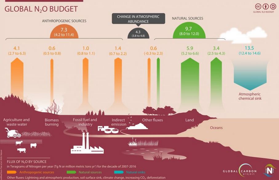
    Human emissions of nitrous oxide (N2O) — a greenhouse gas 300 times more potent than carbon dioxide (CO2) — increased by 30 per cent between 1980 and 2016.

    Observe the above image carefully and try to find out the major contributor of nitrous oxide emission in the Global N2O Budget.

    What is Nitrous oxide?

    • Nitrous oxide is a dangerous gas for the sustainable existence of humans on Earth.
    • It has the third-highest concentration — after CO2 and methane — in our atmosphere among greenhouse gases responsible for global warming.
    • N2O can live in the atmosphere for up to 125 years.
    • Most N2O emissions have come from emerging countries like India, China and Brazil.

    About the research

    • Nitrous oxide global concentration levels have increased from 270 parts per billion (ppb) in 1750 to 331 ppb in 2018 — a jump of 20 per cent.
    • The growth has been the quickest in the past five decades because of human emissions.
    • The research was conducted through an international collaboration between the International Nitrogen Initiative (INI) and the Global Carbon Project of Future Earth, a partner of the World Climate Research Programme.

    Why N2O matters?

    • N2O is also the only remaining threat to the ozone layer, for it accumulates in the atmosphere over a long period of time, just like CO2.
    • The increase in its emissions means that the climatic burden on the atmosphere is increasing from non-carbon sources as well, while the major focus of global climate change negotiations is currently centred on carbon.
    • A major proportion of the N2O emissions in the last four decades came from the agricultural sector, mainly because of the use of nitrogen-based fertilizers.
    • The growing demand for food and feed for animals will further increase global nitrous oxide emissions.
  • What is Global Warming Hiatus (GWH)?

    A new study on variability in the Mascarene High (MH) in the Southern Indian Ocean during global warming hiatus (GWH) has revealed that the region experienced significantly increased sea surface temperature (SST) during this period (1998-2016).

    Try this PYQ:

    Q.With reference to Ocean Mean Temperature (OMT), which of the following statements is/are correct? (CSP 2020)

    1. OMT is measured upto a depth of 26 degree Celsius isotherm which is 129 meters in the south-western Indian Ocean during January-March.
    2. OMT collected during January-March can be used in assessing whether the amount of rainfall in monsoon will be less or more than a certain long-term mean.

    Select the correct answer using the code given below:
    (a) 1 only
    (b) 2 only
    (c) Both 1 and 2
    (d) Neither 1 nor 2

    What is Global Warming Hiatus (GWH)?

    • A global warming hiatus is referred to a global warming pause, or a global warming slowdown, which is a period of relatively little change in globally averaged surface temperatures.
    • The hiatus, however, can result in an increase in the SST.

    What is Mascarene High (MH)?

    • The Mascarene High (MH) is a semi-permanent subtropical high-pressure zone in the South Indian Ocean.
    • It is also called the Indian Ocean subtropical high, which is a high-pressure area located between 20° to 35° South latitude and 40° to 90° East longitude.
    • It is a region from where the cross-equatorial winds blow to India.
    • It has been named after the Mascarene Islands, in the Indian Ocean east of Madagascar consisting of the islands belonging to Mauritius as well as the French Réunion Islands.
    • Apart from its large influence on African and Australian weather patterns, it also helps in driving the inter-hemispheric circulation between the Indian Ocean in the south and subcontinental landmass in the north.

    Role of MH

    • The warming in SST due to global warming has resulted in a decrease in the pressure gradient between the MH and the Indian landmass.
    • This in turn suppressed the intensity of low-level cross-equatorial winds over the western Indian Ocean affecting the onset of the monsoon over the Indian subcontinent and rainfall over East Asia.
  • [pib] Climate Smart Cities Assessment Framework (CSCAF 2.0)

    The Ministry of Housing and Urban Affairs has launched the Climate Smart Cities Assessment Framework (CSCAF) 2.0.

    About CSCAF 2.0

    • A framework is a climate-sensitive approach to urban planning and development in India.
    • ​It was developed after a review of existing frameworks and assessment approaches adopted throughout the world.
    • It followed a series of an extensive consultative process with more than 26 organizations and 60 experts from different thematic areas.
    • The Climate Centre for Cities under National Institute of Urban Affairs (NIUA) is supporting MoHUA in implementation of CSCAF.

    Various indicators of the framework

    The framework has 28 indicators across five categories namely:

    1. Energy and Green Buildings
    2. Urban Planning, Green Cover & Biodiversity
    3. Mobility and Air Quality
    4. Water Management
    5. Waste Management
  • Mapping: Mont Blanc

    The melting Mont Blanc glacier in the French Alps yielded a clutch of newspapers with banner headlines from when Indira Gandhi became India’s first and so far only woman Prime Minister in 1966.

    Try this MCQ

    Q.The Mont Blanc in the Alps can be located near the conflux of which of the following two countries?

    a)France and Spain

    b)France and Italy

    c)Spain and Italy

    d)Greece and Slovenia

    Mont Blanc

    • Mont Blanc is the second-highest mountain in Europe after Mount Elbrus. It is the highest mountain in the Alps and Western Europe.
    • It rises 4,808 m above sea level and is ranked 11th in the world in topographic prominence.
    • The mountain stands in a range called the Graian Alps, between the regions of Aosta Valley, Italy, and Savoie and Haute-Savoie, France.
    • It is the tallest peak in the Alps and the highest summit in Western Europe, hence its epithet the “Roof of Europe”.
  • What is ‘Last Glacial Maximum’?

    Researchers analysed simulations of this past climate and predicted that the ongoing climate change could reawaken an ancient climate pattern of the Indian Ocean Region (IOR).

    Try this question from CSP 2017:

    Q.With reference to ‘Indian Ocean Dipole (IOD)’, sometimes mentioned in the news while forecasting Indian monsoon, which of the following statements is/are correct?

    1. IOD phenomenon is characterized by a difference in sea surface temperature between tropical Western Indian Ocean and tropical Eastern Pacific Ocean.

    2. An IOD phenomenon can influence El Nino’s impact on the monsoon.

    Select the correct Option using the code given below:

    (a) Only 1

    (b) Only 2

    (c) Both 1 and 2

    (d) Neither 1 nor 2

    The Last Glacial Maximum

    • The Last Glacial Maximum (LGM) was the most recent time during the Last Glacial Period that ice sheets were at their greatest extent.
    • Vast ice sheets covered much of North America, Northern Europe, and Asia and profoundly affected Earth’s climate by causing drought, desertification, and a large drop in sea levels.
    • Growth of ice sheets commenced 33,000 years ago and maximum coverage was between 26,500 years and 19–20,000 years ago, when deglaciation commenced in the Northern Hemisphere.
    • It caused an abrupt rise in sea level.

    Shells predict IOR climate variability

    • By studying microscopic zooplankton called foraminifera, the team had published a paper in 2019 which first found evidence from the past of an Indian Ocean El Niño.
    • Foraminifera builds a calcium carbonate shell, and studying these can tell us about the properties of the water in which they lived.
    • The team measured multiple individual shells of foraminifera from ocean sediment cores and was able to reconstruct the sea surface temperature conditions of the past.
    • The Indian Ocean has the capacity to harbour much larger climate variability than observed during the last few decades or a century.

    Lessons to learn

    • There are many lessons to be learnt from this cooler period about our warmer future.
    • As it is, under present-day conditions, changes in the Indian Ocean Dipole and the El Niño–Southern Oscillation strongly affect Indian Monsoon variability from year to year.
    • If the hypothesized ‘equatorial mode’ emerges in the near future, it will pose another source of uncertainty in rainfall prediction and will likely amplify swings in monsoon rainfall.
    • It could bring more frequent droughts to East Africa and southern India and increased rainfall over Indonesia.

    Back2Basics

    What is the Indian Ocean Dipole? Explain its connection with the Indian monsoons