💥Mains Ready By December. Smash Mains & Smash PYQ Admissions Open

GS Paper: GS1

  • Private players to conserve heritage monuments

    Why in the News?

    The Centre has recently proposed to open conservation of protected monuments to private participation, ending the Archaeological Survey of India’s (ASI) exclusive control over this domain.

    About Archaeological Survey of India (ASI):

    • Establishment: Formed in 1861 under the Ministry of Culture, ASI is responsible for archaeological research, exploration, and protection of India’s cultural heritage.
    • Legal Authority: Enforces the Ancient Monuments and Archaeological Sites and Remains Act, 1958 and the Antiquities and Art Treasures Act, 1972.
    • Scope of Work: Manages about 3,700 centrally protected monuments and archaeological sites of national importance.
    • Organisational Structure: Operates through 37 regional Circles and specialist wings such as Science Branch (material analysis), Horticulture Branch (site maintenance), Temple Survey Projects (documentation), and Underwater Archaeology Wing (submerged heritage).
    • Institutional Challenges: Faces staff shortages, budget limits, and procedural delays, constraining nationwide conservation capacity.

    What is the new Public–Private Partnership (PPP) Model for Conservation?

    • Purpose: Supplements ASI’s work by allowing private participation in conservation of heritage monuments.
    • Participants: Corporates, PSUs, and philanthropic bodies may fund, execute, and monitor restoration projects under ASI supervision.
    • Funding Mechanism: Routed through the National Culture Fund (NCF); donations qualify as CSR expenditure with 100% tax exemption.
    • Implementation Framework:
      • Empanelment of conservation architects via RFP by the Ministry of Culture.
      • Donors select architects, who jointly engage restoration agencies experienced in structures over 100 years old.
      • Each project must have a Detailed Project Report (DPR) approved by ASI and comply with the National Policy for Conservation, 2014.
    • Priority Monuments: 250 sites identified for initial adoption based on region or thematic interest.
    • Eligibility: Proven heritage conservation experience, financial competence, and technical compliance with ASI standards.

    Difference from ‘Adopt a Heritage’ Scheme:

    • Earlier Model (2017, revised 2023): Focused on tourism amenities cafés, ticketing, signage through “Monument Mitras”; excluded structural restoration.
    • Current PPP Model: Extends to scientific conservation and architectural restoration under direct ASI oversight.
    • Regulatory Control: ASI retains authority over authenticity, ethics, and policy compliance; funding channelled via NCF with technical audit.
    • Policy Evolution: Marks a shift from tourism partnership to heritage stewardship, blending private resources with public accountability for monument preservation.
  • World’s Highest Motorable Road constructed at Mig La Pass in Ladakh

    Why in the News?

    The Border Roads Organisation (BRO) has achieved a historic milestone by constructing the world’s highest motorable road at Mig La Pass, situated 19,400 feet above sea level in Ladakh.

    • Strategic Value: Enables rapid troop movement and logistics support in high-altitude sectors; promotes eco-tourism and local trade.

    What is Project Himank?

    • Overview: A flagship Border Roads Organisation (BRO) initiative launched in December 1985 to build and maintain roads in Ladakh’s high-altitude regions.
    • Key Achievements: Built Umling La Road, Chisumle–Demchok, Darbuk–Shyok–DBO, Kargil–Zanskar, and now the Mig La Road (19,400 ft) under severe climatic stress.

    About Mig La Pass:

    • Importance: Crucial for India’s border logistics network, enabling swift troop deployment, supply transport, and surveillance near LAC and LoC.
    • Location: Situated on the Changthang Plateau, eastern Ladakh, near the Line of Actual Control (LAC) with China.
    • Elevation: Stands at 19,400 ft (5,913 m), now the highest motorable road in the world (2025), overtaking Umling La (19,024 ft).
    • Alignment: Lies along the Likaru–Mig La–Fukche route, forming a third strategic link from Hanle to Fukche near the Indo-China border.
    • Connectivity Role: Provides access to remote frontier villages—Hanle, Rongo, Kuyul, and Demchok—improving healthcare, communication, and supply access.
    • Geography: Part of the Changthang cold desert, with thin air, permafrost, and extreme cold, posing major engineering challenges.
    • Historical Link: Follows ancient Indo-Tibetan trade routes, reflecting Ladakh’s role in trans-Himalayan Silk Route exchanges.
    [UPSC 2007] Which one of the following Himalayan passes was reopened around in the middle of the year 2006 to facilitate trade between India and China?

    Options: (a) Chang La (b) Jara La (c) Nathu La* (d) Shipki La


  • India’s only Mud Volcano erupts after 20-years in Andamans

    Why in the News?

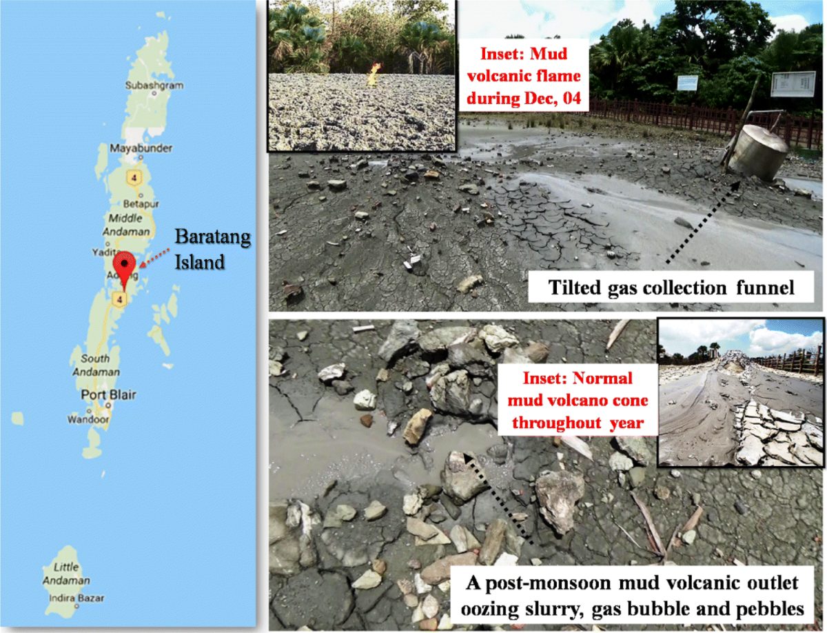
    India’s only mud volcano at Baratang Island in the Andaman and Nicobar Islands erupted after remaining dormant for over two decades.

    India's only Mud Volcano erupts after 20-years in Andamans

    Note: The Barren Island has erupted recently.

    • India’s only active lava volcano, located about 140 km from Port Blair.
    • Lies at the junction of the Indian and Burmese tectonic plates.
    • Eruption history: 1787 (first recorded), followed by episodes in 1991, 2005, 2017, November 2022, and September 2025.

    About the Baratang Mud Volcano:

    • Location: Baratang Island, around 100–150 km north of Port Blair, situated in the North and Middle Andaman district.
    • Uniqueness: It is India’s only collection of mud volcanoes — 11 in total across the archipelago, 8 of which are on Baratang and Middle Andaman.
    • Eruptions: Significant eruptions were last reported in 2005; the 2025 eruption marks the first major event in 20 years.
    • Composition & Nature:
      • Emits cool mud, water, and gases (methane, hydrogen sulfide) rather than lava or fire.
      • Creates mud cones, bubbling pools, or dried crater-like formations.
      • Eruptions are low in intensity, involving slow oozing and gas bubbling rather than violent explosions.
    • Accessibility: A short 160-metre walk from the nearest road; the site lies near the Jarawa Tribal Reserve, where photography is prohibited for ethical and legal reasons.

    Geological Formation and Features:

    • Tectonic Setting: Formed due to subduction of the Indian Plate beneath the Burmese Plate, leading to gas and fluid release from deep layers.
    • Mechanism:
      • Decomposition of organic matter underground produces gas pressure that pushes mud upwards.
      • These gases, along with water and sediments, escape to the surface, creating muddy eruptions and bubbling vents.
    • Temperature & Composition:
      • The expelled material is cool, unlike magmatic volcanoes.
      • Contains saline water, organic sediments, and gases, giving it a distinctive odour and appearance.
    • Earth Processes: The phenomenon helps scientists study fluid migration, methane emissions, and crustal deformation in active subduction zones.
    [UPSC 2018] Consider the following statements:

    1.The Barren Island volcano is an active volcano located in the Indian territory.

    2.Barren Island lies about 140 km east of Great Nicobar.

    3.The last time the Barren Island volcano erupted was in 1991 and it has remained inactive since then.

    Which of the statements given above is/are correct?

    Options: (a) 1 only * (b) 2 and 3 (c) 3 only (d) 1 and 3


  • [pib] First Commercial Coal Mine in Arunachal Pradesh at Namchik-Namphuk

    Why in the News?

    Arunachal Pradesh has launched its first commercial coal mine at the Namchik-Namphuk coal block in Changlang district.

    About the Namchik–Namphuk Coal Mine:

    • Overview: Located in Changlang district, Arunachal Pradesh, is the state’s first commercial coal mine, situated near the Indo-Myanmar border.
    • Reserves & Quality: Holds ~15 million tonnes of lignite/sub-bituminous coal, primarily for thermal power and industrial use.
    • Operator & Allocation: Operated by Coal Pulz Private Limited (CPPL), allotted through a transparent auction in 2022, project first allocated in 2003 but stalled due to environmental and administrative delays.
    • Production & Revenue: Initial capacity of 0.2 million tonnes per annum, expected to generate ₹100 crore annually for the state government.
    • National Context: Marks Arunachal Pradesh’s entry into India’s coal-producing map as the country crosses 1 billion tonnes output (FY 2024-25).
    • Policy Alignment: Supports the EAST Vision (Empower, Act, Strengthen, Transform) for North-Eastern development.

    Significance:

    • Legal Mining: Ends decades of illegal mining through regulated, community-driven extraction.
    • Sustainable Development: Part of Mission Green Coal Regions, targeting 73,000 ha of land reclamation by 2030, embedding ecological restoration into mining.
    [UPSC 2008] In which one of the following states are Namchik-Namphuk Coalfields located?

    Options: (a) Arunachal Pradesh* (b) Meghalaya (c) Manipur (d) Mizoram


  • Thumri maestro Pandit Chhannulal Mishra passes away

    Why in the News?

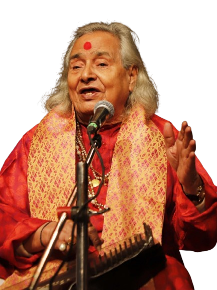
    Pandit Chhannulal Mishra, a maestro of Hindustani classical music and Padma Vibhushan recipient, passed away at 89.

    Who was Pandit Chhannulal Mishra?

    Thumri maestro Pandit Chhannulal Mishra passes away

    • Background: Born in 1936 in Varanasi, Pandit Chhannulal Mishra emerged from a modest family to become one of India’s greatest Hindustani classical vocalists.
    • Musical Lineage: Foremost exponent of the Purab Ang Thumri of the Banaras Gharana, blending the melodic precision of Kirana with the emotive depth of Banaras traditions.
    • Artistic Range: Mastered Thumri, Dadra, Kajri, and Chaiti, combining folk vitality and classical discipline, hallmarks of the Kashi musical spirit.
    • Voice & Expression: His gravelly, resonant voice conveyed devotion, mysticism, and deep emotion, evoking Lord Shiva, the Ganga, and the eternal mood of Banaras.
    • Cultural Symbol: Alongside Ustad Bismillah Khan, he personified the Ganga–Jamuni tehzeeb, symbolising the harmony of Hindu–Muslim artistic traditions.
    • Honours: Recipient of the Padma Vibhushan, his legacy unites classical rigor, folk heart, and spiritual emotion in a single aesthetic stream.

    About Thumri Music:

    • Nature: Thumri is a semi-classical vocal genre of North India known for its emphasis on emotion (bhava) rather than rigid raga structure.
    • Origin: Developed in the 19th century under Nawab Wajid Ali Shah of Lucknow; later enriched in Banaras, where it absorbed devotional and folk influences.
    • Etymology: Derived from thumakna (“to walk gracefully”), reflecting its rhythmic, fluid, and expressive nature tied to Kathak dance.
    • Themes: Revolves around Sringara rasa, love, separation, and devotion especially, Radha-Krishna narratives; often sung from a female perspective.
    • Language: Primarily in Braj Bhasha, Awadhi, and Hindi, with traces of Urdu and Sanskrit.
    • Musical Features:
      • Uses popular ragas like Bhairavi, Khamaj, Kafi and tālas like Dadra and Keherva.
      • Allows improvisation, vocal ornamentation (murki, meend, gamak), and interpretive freedom.
    • Forms of Thumri:
      • Bandish-ki-Thumri: Structured composition, rhythmically defined.
      • Bol-Banao Thumri: Lyrical, slow, emotive style allowing deeper expression.
    • Major Gharanas:
      • Lucknow Gharana: Courtly refinement and dance association (Begum Akhtar).
      • Banaras Gharana: Devotional Purab Ang tradition (Girija Devi, Rasoolan Bai, Siddheshwari Devi, Chhannulal Mishra).
      • Patiala Gharana: Fast, rhythm-oriented style with tappa influence (Bade Ghulam Ali Khan).

    Thumri and Indian Classical Tradition:

    • Position in the Hindustani system:
      • Thumri is semi-classical, bridging the gap between pure classical forms (like Khayal and Dhrupad) and folk/dance traditions.
      • It prioritises emotional storytelling over technical display, making classical music accessible to the wider public.
    • Connection with Kathak:
      • Thumri complements Kathak dance, aiding abhinaya (expressive gesture) through musical narration.
    • Hindustani vs Carnatic contrast:
      • Hindustani classical music (North India) focuses on raga improvisation;
      • Carnatic music (South India) is composition-centric with structured kritis and rigid tala frameworks.
    • Cultural Role:
      • Thumri mirrors the fusion of classical, folk, and devotional idioms, symbolising India’s cultural inclusivity.
      • It thrives on the interplay of bhava (emotion), raga (melody), and laya (rhythm)—a trinity central to Indian aesthetics.
    [UPSC 2019] With reference to Mian Tansen, which one of the following statements is not correct? Options: (a)Tansen was the title given to him by Emperor Akbar.*

    (b) Tansen composed Dhrupads on Hindu gods and goddesses.

    (c) Tansen composed songs on his patrons.

    (d) Tansen invented many Ragas.


  • What are Flying Rivers/ Atmospheric Rivers?

    Why in the News?

    Droughts and fires in South America highlight the importance of “flying rivers” — rain-bearing vapor streams disrupted by Amazon deforestation.

    What are Atmospheric Rivers?

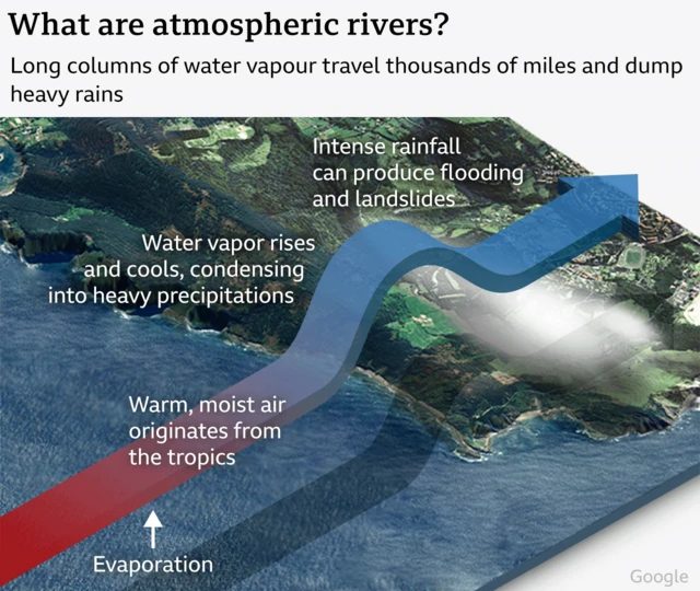
    • Overview: Long, narrow bands of concentrated water vapour in the lower atmosphere, often termed “rivers in the sky.”
    • Dimensions: Typically 2,000–5,000 km long, 400–500 km wide, and about 3 km deep.
    • Water Transport: Carry nearly 90% of water vapour across Earth’s mid-latitudes — almost double the Amazon River’s flow.
    • Formation: Warm tropical seawater evaporates, and winds transport this moisture; upon encountering land or mountains, vapour condenses into heavy rainfall or snow.
    • Role: Unlike short-term weather systems, Atmospheric Rivers (ARs) shape long-term hydrological cycles and trigger extreme precipitation events.

    Global Impacts of Atmospheric Rivers:

    • Flooding & Extreme Weather: Cause 80% of flood-related damages along the US West Coast; also linked to devastating floods in Europe, Africa, South America, and Australia.
    • South America: Amazon’s “flying rivers” disrupted by deforestation, leading to droughts in Peru, Bolivia, and Ecuador; threatens Amazon rainforest’s survival and risks savannisation.
    • East Asia: Up to 80% of heavy rainfall events in China, Korea, and Japan during early monsoon linked to ARs.
    • Climate Connection: Warming oceans are making ARs longer, wider, and more intense, increasing risks of catastrophic floods and landslides.
    • Positive Role: Contribute 30–50% of annual precipitation in some regions (e.g., US West Coast) and help end 33–74% of droughts.

    Atmospheric Rivers in India’s Context:

    • Interaction: ARs combine with cyclonic circulations and the Himalayan ranges, causing extreme rainfall and flash floods.
    • Case Studies:
      • 2010 Leh cloudburst (Ladakh) – flash floods and mudslides.
      • 2011 Kupwara floods (J&K) – severe AR-driven rainfall.
    • Study (1951–2020): Identified 574 AR events during the monsoon season in India.
    • Recent Trends: Nearly 80% of India’s most severe floods (1985–2020) linked to AR activity.
    • Cause: Rapid Indian Ocean warming intensifies evaporation, moisture transport, and AR-driven floods.
    • Impact: Leads to short, intense rainfall spells, landslides, flash floods, crop loss, and mass displacement of communities.
    [UPSC 2024] With reference to “water vapour,” which of the following statements is/are correct?

    1. It is a gas, the amount of which decreases with altitude.

    2. Its percentage is maximum at the poles.

    Select the answer using the code given below:

    Options: (a) 1 only* (b) 2 only (c) Both 1 and 2 (d) Neither 1 and 2


  • Climate Models and Their Accuracy

    Why in the News?

    The US President Donald Trump called climate change the “greatest con job ever,” disgusted with the predictions based on climate models central to climate science.

    Climate Models and Their Accuracy

    What are Climate Models?

    • Overview: Climate models are computer simulations using mathematical equations to represent the Earth’s climate system, including the atmosphere, oceans, land surface, and ice.
    • Basis: Built on physics, chemistry, and biology, they simulate interactions among Earth’s components.
    • Purpose: Forecast temperature, rainfall, humidity, sea-level rise, and extreme weather under scenarios like high greenhouse gas emissions.
    • Difference from Weather Models: Weather models predict short-term local events, while climate models analyze long-term regional and global patterns.

    How do Climate Models work?

    • Grid System: Earth divided into a 3D grid of cells across land, atmosphere, and oceans.
    • Equations: Each cell governed by equations on energy movement, air, ice, and land processes.
    • Data Input: Observational data (greenhouse gases, ocean conditions, land use) fed into the model.
    • Interactions: Equations simulate changes in each cell and their effects on neighboring cells.
    • Outputs: Provide projections for temperature, precipitation, sea levels, ice cover, and extreme climate events.

    Evolution of Climate Models:

    Model Type What is it? Strengths Limitations
    Energy Balance Models (EBMs) 

    (1960s)

    • The earliest climate models.
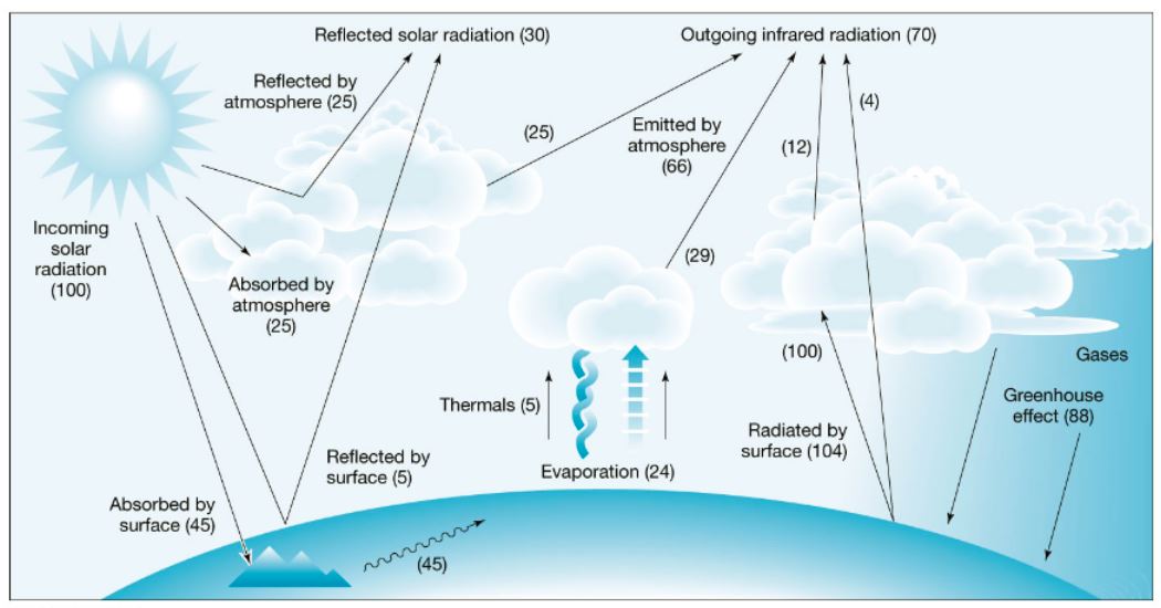
    • They treat Earth like a single box system, calculating surface temperature by balancing incoming solar radiation vs outgoing infrared radiation.
    • Essentially, they answer: “How warm should Earth be if X amount of energy comes in and Y amount goes out?”
    • Very simple; first to link CO₂ emissions with global warming.
    • Computationally inexpensive.
    • Oversimplified — ignores atmosphere, oceans, and circulation.
    • Cannot simulate rainfall, winds, or regional climate.
    Radiative Convective Models (RCMs) 

    (1960s–70s)

    • Introduced the vertical structure of the atmosphere.
    • They divide the atmosphere into layers and simulate how radiation (solar + infrared) and convection move heat upward and downward.
    • Show how greenhouse gases trap heat and alter temperatures at different heights.
    • Capture greenhouse effect more realistically;
    • Explain vertical temperature profiles;
    • Useful for studying stratospheric cooling.
    • Still ignore oceans and global circulation;
    • Cannot project regional variations or weather patterns.
    General Circulation Models (GCMs) (Global Climate Models)

    (1970s onwards)

    • The first 3D models of Earth’s climate.
    • Divide the planet into grid cells (100–250 km), each with equations for atmosphere, oceans, ice, and land.
    • Simulate winds, currents, rainfall, temperature, and pressure by solving physical equations of motion, energy, and mass.
    • Comprehensive representation of climate;
    • Simulate monsoon, El Niño, ocean currents; reproduce past climate trends.
    • Very resource-intensive; grid too coarse to capture local detail (cities, villages);
    • Uncertainty in clouds and aerosols.
    Earth System Models (ESMs)

    (1990s–present)

    • Advanced GCMs that integrate biogeochemical cycles (carbon cycle, vegetation, ocean chemistry, aerosols, land-use changes).
    • Show how human activities (deforestation, fossil fuels, pollution) interact with natural systems, feedback loops, and long-term climate.
    • Holistic view of climate–biosphere interactions;
    • Essential for IPCC reports and policy projections.
    • Extremely complex;
    • Uncertainties in carbon feedbacks, aerosols, and long-term ecological processes.
    Regional Climate Models (RCMs)

    (1990s–present)

    • High-resolution versions of GCMs, zoomed into specific regions (25–50 km grids).
    • Use downscaling techniques to provide localised forecasts of rainfall, temperature, droughts, and monsoons.
    • Useful for city- or country-level policy (flood risk, agriculture, urban heat);
    • Capture Indian monsoon and Himalayan glaciers better.
    • Dependent on GCM input;
    • Projections limited to chosen region;
    • Computationally intensive.

    How accurate are Climate Models?

    • Strengths: Modern models predict sea-level rise, polar ice loss, temperature increases, and rainfall trends with high accuracy.
    • Validation: Predictions are compared with historical climate records to confirm reliability.
    • Limitations:

      • Lack of precise data on clouds, volcanic activity, El Niño events.
      • Limited accuracy for regional variations (e.g., urban floods, Indian monsoon extremes).
      • Less accuracy in Global South due to data scarcity and complex climate systems.
      • Grid resolution (100–250 km per cell) causes oversimplification of land–atmosphere interactions.
    [UPSC 2025] The World Bank warned that India could become one of the first places where wet-bulb temperatures routinely exceed 35°C. Which of the following statements best reflect(s) the implication of the above-said report?

    I. Peninsular India will most likely suffer from flooding, tropical cyclones and droughts.

    II. The survival of animals including humans will be affected as shedding of their body heat through perspiration becomes difficult.

    Select the correct answer using the code given below:

    (a) I only      (b) II only      (c) Both I and II      (d) Neither I nor II


  • More Women employed in agriculture, but half of them are unpaid

    Introduction

    Women-led development is increasingly recognised as a structural game-changer for India’s economic ambitions. Nowhere is this more urgent than in agriculture, which not only sustains livelihoods but also employs the largest share of India’s female workforce. However, while women’s participation in farming has risen sharply due to men shifting to non-farm jobs, their contributions remain largely invisible, unpaid, and undervalued. This contradiction calls for a deeper exploration of systemic inequities and emerging opportunities to turn agriculture into a vehicle for women’s empowerment and national growth.

    The Feminisation of Agriculture: Numbers Behind the Shift

    1. Surge in women workers: Women’s employment in agriculture rose by 135% in a decade, now accounting for 42% of the agricultural workforce.
    2. Unpaid work: The number of women as unpaid family workers increased 2.5 times, from 23.6 million in 2017–18 to 59.1 million in 2023–24 (PLFS).
    3. Regional inequities: In States like Bihar and Uttar Pradesh, over 80% of women workers are in agriculture, and more than half receive no wages.
    4. National picture: Today, one in three working women in India is unpaid.

    Why Women’s Work in Agriculture Remains Invisible

    1. Lack of recognition: Women are not officially recognised as farmers despite constituting a large share of labour.
    2. Skewed land ownership: Only 13–14% of land holdings are in women’s names, limiting access to credit, insurance, and government support.
    3. Wage gap: Women earn 20–30% less than men for equivalent agricultural tasks.
    4. Concentration in low-value work: Women are locked into subsistence farming and low-margin tasks without decision-making power.
    5. Macro impact: Despite higher participation, agriculture’s share in GVA fell from 15.3% (2017–18) to 14.4% (2024–25), reinforcing inequities instead of enabling empowerment.

    Global Trade Trends as an Opportunity

    1. India–U.K. FTA: Expected to boost agricultural exports by 20% within three years, covering 95% of agricultural and processed food products duty-free.
    2. Export-oriented crops: Women already have strong representation in spices, tea, millets, rice, dairy- sectors poised for expansion.
    3. From labourers to entrepreneurs: With training, credit access, and market linkages, women could transition to income-generating entrepreneurs in value-added exports.

    Technology as a Game-Changer

    1. Digital agriculture: Platforms like e-NAM, mobile advisory services, precision tools connect women to markets and pricing systems.
    2. Language and literacy gap: Women face low digital literacy, language barriers, and lack of devices, restricting adoption.
    3. Promising models:
      1. BHASHINI platform and Microsoft–AI4Bharat’s Jugalbandi provide multilingual, voice-first government access.
      2. L&T Finance’s Digital Sakhi programme has built digital and financial literacy among rural women in seven States.
      3. Odisha’s Swayam Sampurna FPOs and Jhalawari Mahila Kisan Producer Company (Rajasthan) leverage digital tools for branding and exports.

    Structural Reforms Needed

    1. Land reforms: Promote joint or individual land ownership to strengthen women’s eligibility for formal support.
    2. Labour reforms: Recognise women as independent farmers to ensure fair wages, rights, and credit.
    3. Value chain inclusion: Shift women into higher-margin activities like processing, branding, packaging, and exporting.
    4. Institutional support: Scale multi-stakeholder programs (government, NGOs, FPOs) to dismantle structural inequities.

    Conclusion

    The feminisation of agriculture in India highlights a double-edged reality: while women have become indispensable to the sector, their economic contributions remain unrecognised and unpaid. With global trade shifts, digital innovations, and land-labour reforms, India now stands at a crossroads. Whether women remain invisible labourers or emerge as empowered entrepreneurs will depend on how decisively policymakers, private actors, and civil society act to bridge systemic inequities. Women’s empowerment in agriculture is not just a gender issue, it is central to India’s economic transformation.

    PYQ Relevance

    [UPSC 2024] Distinguish between gender equality, gender equity and women’s empowerment. Why is it important to take gender concerns into account in programme design and implementation?

    Linkage: The question probes the conceptual clarity between equality, equity, and empowerment while testing their application in real policy frameworks. It aligns with the article as the feminisation of agriculture highlights how ignoring gender concerns in land, labour, and trade programmes perpetuates invisibility of women’s work, whereas equity-driven reforms can transform participation into genuine empowerment.

  • [pib] Who was Rani Rashmoni (1793-1861)?

    Why in the News?

    The Prime Minister has paid tribute to Rani Rashmoni on her birth anniversary on 28th September.

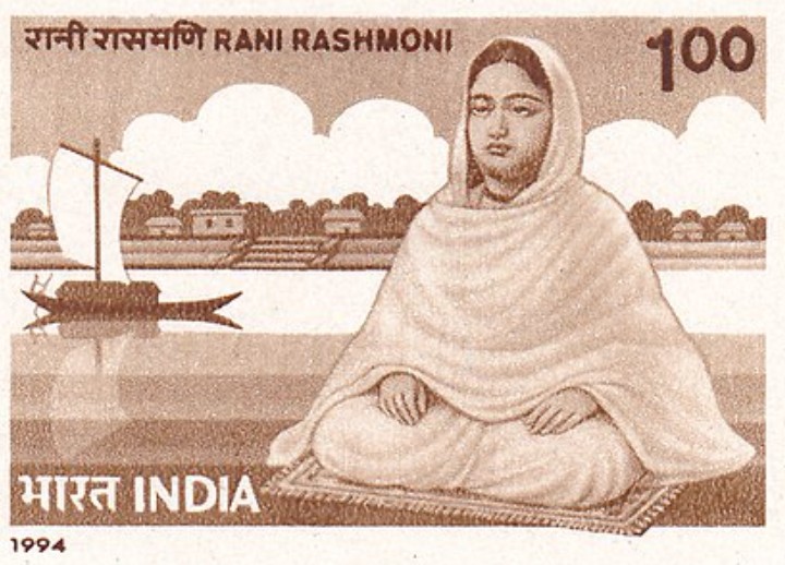
    Rani Rashmoni (1793-1861)

    Who was Rani Rashmoni (1793–1861)?

    • Overview: A prominent zamindar, businesswoman, philanthropist, and social reformer from 19th-century Bengal.
    • Birth: Born on 28 September 1793 in Halisahar, Bengal.
    • Marriage: Married at the age of 11 to Raja Raj Chandra Das, wealthy zamindar of Janbazar, Kolkata.
    • Leadership: Took charge of the estate and business after her husband’s death in 1836, unusual for women of her time.
    • Reputation: Revered as “Lokmata” (Mother of the People) for her courage, administration, and social commitment.

    Her Contributions:

    • Patronage: Built the Dakshineswar Kali Temple (1847–1855); appointed Sri Ramakrishna Paramahamsa as chief priest despite caste opposition.
    • Social Reforms: Opposed polygamy and child marriage; supported widow remarriage; submitted a draft bill against polygamy to the British.
    • Public Welfare & Infrastructure: Constructed major ghats on the Ganga including Babughat, Ahiritola Ghat, Nimtala Ghat. Funded roads, reservoirs, and pilgrim facilities, such as the road from Subarnarekha River to Puri.
    • Resistance to British Rule: Fought against fishing taxes on Hooghly fishermen by blocking river traffic, compelling British to abolish the tax. Defied British restrictions on Durga Puja processions, preserving traditions.
    • Support for Education & Culture: Donated to the Imperial Library (now National Library of India) and Hindu College (now Presidency University). Established schools for women and marginalized groups.
    [UPSC 2024] Consider the following statements about Raja Ram Mohan Roy:

    I. He possessed great love and respect for the traditional philosophical systems of the East.

    II. He desired his countrymen to accept the rational and scientific approach and the principle of human dignity and social equality of all men and women.

    Which of the statements given above is/are correct?

    (a) I only (b) II only (c) Both I and II* (d) Neither I nor II


  • Ganga River is drying faster than in 1,300 years: Report

    Why in the News?

    A recent study by researchers from IIT Gandhinagar and the University of Arizona warns that the Ganga River is drying at a rate unseen in more than a millennium.

    About Drying of the Ganga River: New Study Findings

    • Overview: Reconstructed streamflow since 700 AD using tree-ring records (Monsoon Asia Drought Atlas) and hydrological models. Validated against historic droughts and famines such as the Bengal famine.
    • Findings:

      • Between 1991 and 2020, multiple droughts lasted 4–7 years, the rarest in the past 1,300 years.
      • The 2004–2010 drought was the most severe in 1,300 years.
      • Post-1990s drying was 76% more intense than the worst 16th-century drought.
    • Causes:

      • Weaker monsoons from Indian Ocean warming and aerosol pollution.
      • Groundwater over-extraction reducing river baseflow.
      • Land-use change disrupting natural recharge.
    • Climate Models: Most fail to reproduce the drying trend, raising doubts about optimistic rainfall projections.
    • Implications: Severe threats to agriculture, 600 million livelihoods, Bay of Bengal ecosystems, and the 40% GDP share of the basin. Calls for adaptive water management.

    ganga

    About the Ganga River:

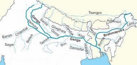
    • Length: ~2,525 km, the longest river in India.
    • Origin: Gangotri Glacier in Uttarakhand at 3,892 m elevation as Bhagirathi.
    • Formation: Named Ganga at Devprayag after meeting Bhagirathi and Alaknanda.
    • Course: Flows through Uttarakhand, Uttar Pradesh, Bihar, Jharkhand, West Bengal before entering Bangladesh as Padma and emptying into the Bay of Bengal through the Sundarbans Delta.
    • Basin: Covers about 8.61 lakh sq. km, which is 26.4% of India’s area.
    • Tributaries:

      • Left bank: Ramganga, Gomti, Ghaghara, Gandak, Burhi Gandak, Koshi, Mahananda.
      • Right bank: Yamuna, Tons, Karamnasa, Sone, Punpun, Falgu, Kiul, Chandan, Ajoy, Damodar, Rupnarayan.
    • Population: Supports over 600 million people, making it the world’s most densely populated river basin.
    • Cultural Importance: Sacred in Indian culture; declared National River in 2008.
    • Economic Role: Central to agriculture, fisheries, and trade, contributing about 40% of India’s GDP.
    • Ecological Significance: Home to snow leopard, elephants, and Ganga dolphin; includes Corbett, Dudhwa, and Sundarbans reserves.
    • Conservation Efforts: Ganga Action Plan (1985) and Namami Gange Programme (2014); persistent issues of pollution, over-extraction, and climate change.
    [UPSC 2024] With reference to the Himalayan rivers joining the Ganga downstream of Prayagraj from West to East, which one of the following sequences is correct?

    Options: (a) Ghaghara – Gomati – Gandak – Kosi

    (b) Gomati – Ghaghara – Gandak – Kosi*

    (c) Ghaghara – Gomati – Kosi – Gandak

    (d) Gomati – Ghaghara – Kosi – Gandak