💥Mains Ready By December. Smash Mains & Smash PYQ Admissions Open

GS Paper: GS1

  • 1950 Assam Earthquake and Future Seismic Risks in the Himalayas

    Why in the News?

    75 years ago on August 15, 1950, a magnitude 8.6 earthquake — the strongest recorded on land — struck Northeast India and surrounding regions.
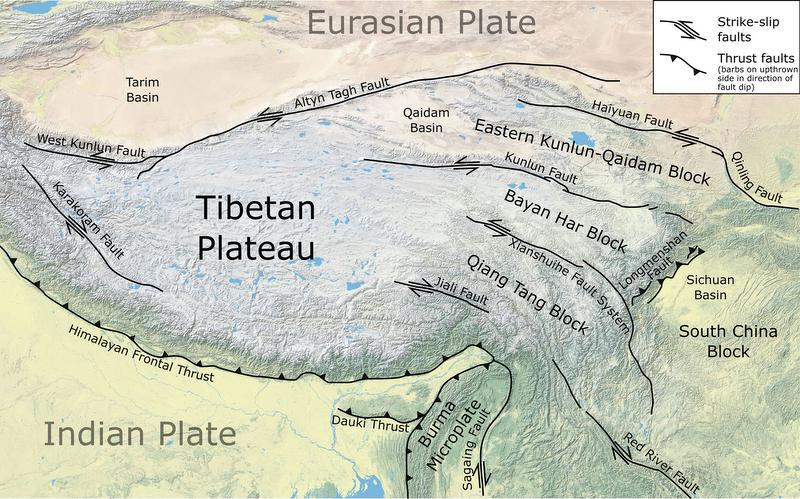
    1950 Assam Earthquake and Future Seismic Risks in the Himalayas

    About the Earthquake:

    • Magnitude: 8.6, the strongest recorded earthquake on land.
    • Impact Area: Tremors lasted 4–8 minutes, felt over 3 million sq. km in India, Myanmar, Bangladesh, Tibet, and South China.
    • Casualties: Over 1,500 deaths in India and 4,000+ in Tibet; heavy livestock losses and infrastructure destruction.
    • Secondary Disasters: Triggered landslides blocking rivers, followed by devastating flash floods.

    Geological and Tectonic Setting:

    • Epicentre: 40 km west of Rima (Zayu), near India–Tibet border in the Mishmi Hills.
    • Tectonic Context: Located on Indian–Eurasian Plate boundary within Eastern Himalayan Syntaxis (EHS), influenced by the Sunda Plate.
    • Fault Type: Strike-slip motion with thrust faulting — atypical for Himalayan quakes.
    • Plate Convergence: Eastern Himalayas converge at 10–38 mm/year vs. ~20 mm/year elsewhere.
    • Aftershocks: Indicated activation of multiple faults from the Syntaxial bend to Himalayan thrust faults in Arunachal Pradesh.

    Lessons and Future Risks:

    • Magnitude Potential: Confirms Himalayan segments can produce ≥8.6 magnitude events.
    • Central Himalayan Risk: Identified as likely site for similar future quake.
    • Vulnerability Today: Increased due to urbanisation and large infrastructure in seismic zones.
    • Infrastructure Safety: Necessitates strict norms for dams and high-risk projects in Eastern Himalayas.
    • Preparedness: Highlights need for seismic hazard mapping and disaster readiness.
    [UPSC 2024] Consider the following statements:

    1. In a seismograph, P waves are recorded earlier than S waves.

    2. In P waves, the individual particles vibrate to and fro in the direction of waves propogation whereas in S waves, the particles vibrate up and down at right angles to the direction of wave propagation. Which of the statements given above is/are correct?

    Options: (a) 1 only (b) 2 only (c) Both 1 and 2* (d) Neither 1 nor 2


  • Dhiri Bull Fighting Festival of Goa

    Why in the News?

    Many legislators of the Goa Assembly across party lines demanded the legalisation of Dhiri Bull Fighting in Goa.

    About Dhiri Bull Fighting:

    • Overview: Goan sport where two bulls lock horns in paddy fields or grounds.
    • Cultural Link: Associated with post-harvest feasts and church celebrations.
    • Nature of Contest: Bulls push until one retreats; no matadors or killing involved.
    • Event: Bulls given unique names, treated like local icons.
    • Betting: High-stakes wagers involve locals and Goan diaspora.

    Recent Controversy:

    • Legal Ban: Banned in 1997 under Prevention of Cruelty to Animals Act after a fatality.
    • Judicial Position: Supreme Court upheld the ban; events continue secretly.
    • Political Push: Lawmakers (2024–25) seek legalisation for cultural/tourism value.
    • Proposed Model: Advocates want regulated events, citing Jallikattu’s example.
  • In news: Dardanelles Strait

    Why in the News?

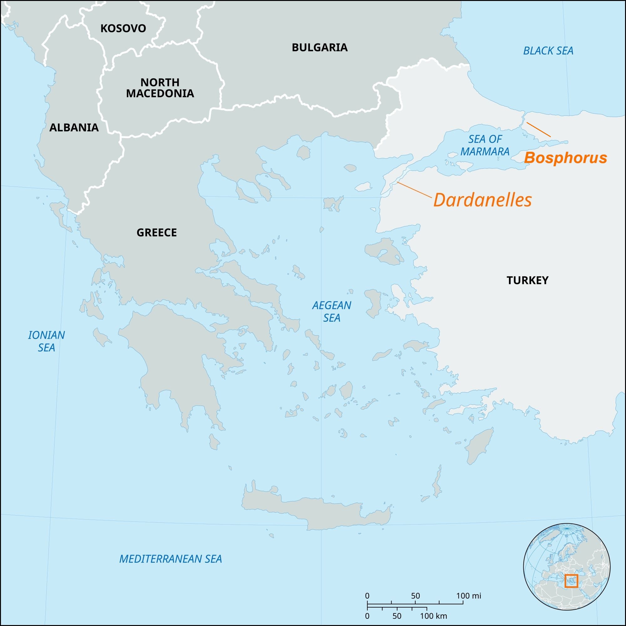
    The Dardanelles Strait in northwestern Turkey has been temporarily closed to maritime traffic due to forest fires near Canakkale, prompting evacuations and firefighting operations.

    About Dardanelles Strait:

    • Location: Northwestern Turkey; separates Gallipoli Peninsula (Europe) from Troad/Biga Peninsula (Asia).
    • Connection: Links Aegean Sea → Sea of Marmara → Bosporus → Black Sea.
    • Dimensions: Length 61 km, width 1.2–6.5 km, average depth 55 m, max depth 103 m.
    • Historical Name: Hellespont, named after mythical princess Helle; current name from ancient city of Dardanus.
    • Currents: Surface current flows from Sea of Marmara to Aegean; saline undercurrent in reverse.
    • Ports: Gallipoli, Eceabat, Çanakkale.

    Strategic & Economic Importance:

    • Part of Turkish Straits system with Bosporus; only maritime link between Black Sea and Mediterranean.
    • Critical for Black Sea nations’ trade (Russia, Ukraine, Bulgaria, etc.).
    • Major route for grain, oil, energy shipments from Black Sea region to global markets.
    • Governed by Montreux Convention (1936) for warship passage.
    • Vital for NATO naval strategy and maritime security.
    [UPSC 2008] Through which one of the following Straits does a tunnel connect the United Kingdom and France?

    Options: (a) Davis Strait (b) Denmark Strait (c) Strait of Dover* (d) Strait of Gibraltar


  • In news: Kerala’s Muthuvan Tribe

    Why in the News?

    The Muthuvan Adivasi Samudaya Sangam organised a convention on the International Day of the World’s Indigenous Peoples.

    In news: Kerala’s Muthuvan Tribe

    About Muthuvan Tribe:

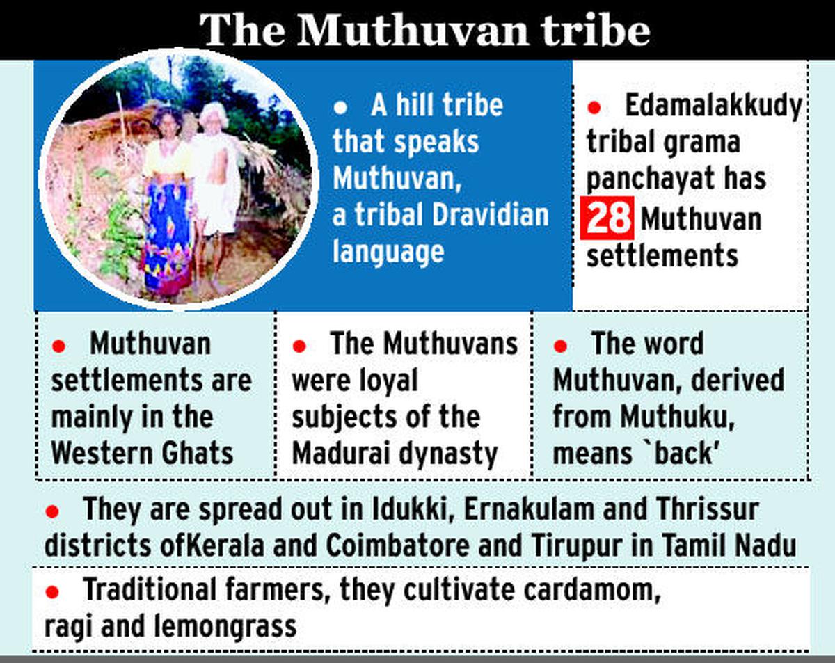
    • Location: Indigenous tribe recognized as STs of the Anaimalai Hills (Kerala & Tamil Nadu); concentrated in Idukki, Ernakulam, Thrissur districts.
    • Etymology: Name means “one who carries weight on the back”, linked to migration from Madurai carrying children and the king.
    • Origins: Traced to the Pandya Kingdom; divided into Malayalam Muthuvan and Pandi Muthuvan dialect groups.
    • Settlements: “Kudis” deep in hill forests; houses made from reeds, leaves, mud.
    • Population: Around 15,000–25,000; among Kerala’s least educated tribes.
    • Governance: Kani System (village headman) and Chavadis (dormitory for unmarried youth).

    Distinct Features:

    • Language: Tamil-related dialect; endangered; preservation efforts underway.
    • Livelihood: Traditionally shifting cultivation (“Virippukrishi”); now grow cardamom, ginger, pepper, lemongrass.
    • Religion: Animism & spirit worship; reverence for Subramanya, Hindu deities, and Kannagi tradition.
    • Customs: Matrilineal descent, tribe endogamy & clan exogamy; collective eating (“koodithinnuthu”); herbal medicine knowledge kept within tribe.
    • Culture: Distinct attire; strong ecological ethics, harmonious forest–wildlife coexistence.
    • Festivals: Thai Pongal is main religious & harvest festival.
    [UPSC 2014] Which one of the following statements is not correct about Scheduled Tribes in India?

    (a) There is no definition of the Scheduled Tribe in the Constitution of India. (b) North-East India accounts for a little over half of the country’s tribal population. (c) The people known as Todas live in the Nilgiri area. (d) Lotha is a language spoken in Nagaland


  • In news: Dard-Shin Tribe

    Why in the News?

    In recent years, community member few activists have emerged documenting and preserving Dard-Shin heritage.

    About the Dard-Shin Tribe:

    • Origin: Ancient Indo-Aryan group from migrations (2000–1500 BCE).
    • Historical Mentions: Herodotus, Pliny, Ptolemy, Kalhana’s Rajatarangini.
    • Homeland: Dardistan – Chitral, Yasin, Gilgit, Chilas, Bunji, Gurez Valley, Ladakh, N. Afghanistan.
    • Political History: Chak dynasty ruled Kashmir for 25+ years in the 16th century before Mughal takeover.
    • Current Location: Gurez (Bandipora, J&K), smaller clusters in Drass, Tulail, Chanderkote.
    • Status & Language: Scheduled Tribe; speak Shina, distinct from Kashmiri.
    • Population: ~48,440 (2011 Census).
    • Livelihood: Farming, pastoralism, forest produce, handicrafts; tourism rising.

    Cultural Significance:

    • Heritage: Among the last Indo-Aryan groups in the Himalayas, preserving language and traditions.
    • Historic Role: Gurez Valley – Silk Route link between Kashmir, Central Asia, Tibet.
    • Traditions: Rich marriage customs, wool attire, juniper leaf burning for land purification.
    • Architecture: Mix of ancient wooden style and modern influences; tools suited for mountain climate.
    • Oral History: Migration legends, e.g., families from Gilgit to Ladakh.
    • Religion: Islam, Buddhism, remnants of animism from cultural exchanges.
    [UPSC 2014] With reference to ‘Changpa’ community of India, consider the following statements:

    1. They live mainly in the State of Uttarakhand.

    2. They rear the Pashmina goats that yield a fine wool.

    3. They are kept in the category of Scheduled Tribes.

    Which of the statements given above is/are correct?

    Options: (a) 1 only (b) 2 and 3 only* (c) 3 only (d) 1, 2 and 3 only


  • Mauryan-Era archaeological discoveries at Topra Kalan, Haryana

    Why in the News?

    A Ground Penetrating Radar survey in Topra Kalan, Haryana, has uncovered signs of a 1,500 BCE settlement, with painted grey ware (PGW), stamped pottery, moulded bricks, and a possible Buddhist stupa.

    About Topra Kalan Excavation:

    • Agencies: Haryana Archaeology and Museums Department with Indian Institute of Technology Kanpur.
    • Method: Ground Penetrating Radar survey in January 2025 to map subsurface features without extensive digging.
    • Purpose: Assess archaeological significance and preserve ancient heritage sites in Haryana.
    • Location: Topra Kalan, Yamunanagar district — believed to be the original site of the Delhi-Topra Ashokan pillar moved by Firoz Shah Tughlaq in the 14th century.
    • Estimated Age: ~1,500 BCE, indicating continuous habitation and possible Buddhist presence.

    Key Findings:

    • Structures: Buried walls, platforms, and room-like enclosures at 4–5 m depth.
    • Religious Feature: Dome-like structure possibly a Buddhist stupa.
    • Material Culture: Painted grey ware, black-and-red ware, black-on-red ware, black ware, stamped pottery, moulded bricks, beads.
    • Discovery Sources: Both official surveys and artifacts unearthed by locals during construction.
    • Historical Links: Accounts by Sir Alexander Cunningham and Hiuen Tsang identify the site as a Buddhist centre.
    [UPSC 2024] Consider the following information:

    Archaeological Site :: State :: Description

    1. Chandraketugarh : Odisha : Trading Port town

    2. Inamgaon : Maharashtra : Chalcolithic site

    3. Mangadu : Kerala : Megalithic site

    4. Salihundam : Andhra Pradesh : Rock-cut cave shrines

    In which of the above rows is the given information correctly matched?

    Options: (a) 1 and 2 only  (b) 2 and 3 only* (c) 3 and 4 (d) 1 and 4


  • Sleeping disasters: Cloudbursts

    Cloud Burst:

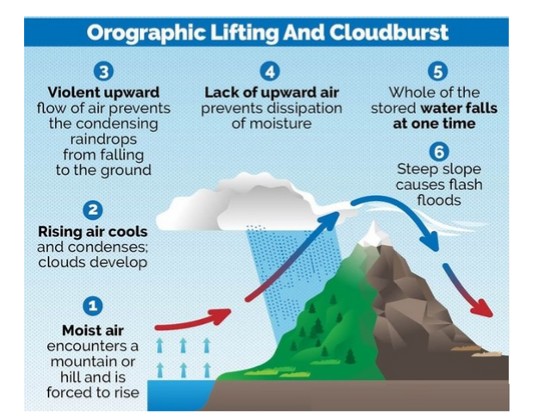
    A cloudburst is an extremely intense, localized shower, defined by the India Meteorological Department (IMD) as at least 100 mm of rain within one hour over 10 sq km. These events occur due to deep, rapid atmospheric uplift over steep terrain, typical of high-altitude Himalayan regions. They can trigger sudden flash floods and landslides, devastating communities in mountainous regions. The term does not refer to a literal bursting cloud but to rapid precipitation from cumulonimbus clouds, sometimes accompanied by thunder or hail.

    Why was the recent Uttarkashi Disaster not a Cloudburst?

    1. Despite initial reports, Uttarkashi district did not record any cloudburst-level rainfall. Actual rainfall was only light to moderate, ranging from 8 mm to 43 mm on Aug 5, far below the 100 mm/hour threshold
    2. The region lacked weather radar coverage at that altitude, so precise measurements were unavailable and the “cloudburst” classification was premature.
    3. Uttarkashi’s steep, rugged topography, with narrow valleys and loose debris, turned the soil into unstable slopes.
    4. A debris-laden flood, possibly triggered by a glacial lake burst, glacier collapse, or landslide, raced downstream as mud and silt-laden water to hit Dharali village violently.

    Reasons for occurrence of cloudbursts:

    1. Cloudbursts happen when warm, moist air quickly rises over mountains, cools down, and turns into heavy rain. This process, called orographic lift, causes the air to release a large amount of rain in a short time.
    2. Sudden mixing of warm and cold air
    3. Strong upward air movement (convection) and high moisture in the air at high altitudes

    Why Do Cloudbursts Happen In The Hills?

    1. Topography: Mountains force moist air to rise rapidly, causing sudden cooling and condensation.
    2. Weather Conditions: Warm air with high moisture content meets cooler air at high altitudes. This results in intense convection and localised torrential rain.

    Can cloudbursts be forecast?

    1. The India Meteorological Department (IMD) forecasts rainfall events well in advance, but it does not predict the quantum of rainfall,  in fact, no meteorological agency does.
    2. IMD gives general rainfall forecasts (light, heavy, very heavy), but not exact amounts.
    3. These forecasts are for large areas like districts or states, not specific locations.
    4. Cloudbursts can’t be predicted exactly due to tech limitations and lack of dense instruments.
    5. However, warnings for very heavy rain (which may lead to cloudburst-like events) are given 6–12 hours in advance.

    Impacts of cloud burst:

    1. Flash Floods: The most immediate and destructive impact is the rapid overflowing of rivers and streams, leading to widespread flooding of low-lying areas.
    2. Landslides and Mudslides: The excessive water saturates the soil on slopes, leading to the rapid downward movement of earth, rocks, and debris, causing significant destruction and posing a threat to human lives and infrastructure.
    3. Soil Erosion: The intense rainfall can wash away topsoil, degrading the land and negatively affecting agriculture.
    4. Land Subsidence: The weakening of the ground due to excessive water absorption can cause the sudden sinking or settling of the Earth’s surface
    5. Loss of Life: The suddenness and intensity of cloudbursts often leave little time for evacuation.
    6. Damage to Infrastructure: Roads, bridges, homes, and public utilities can be severely damaged or completely destroyed.

    While the term “cloudburst” often evokes images of catastrophic floods and landslides, it’s crucial to adopt a nuanced approach, avoiding knee-jerk reactions and recognizing that not all instances of heavy rainfall are cloudbursts. While the unpredictable ferocity of cloudbursts remains a formidable challenge, a proactive blend of scientific innovation, infrastructure resilience, and community-centric preparedness offers the compass to navigate their escalating threat, particularly in fragile ecosystems like the Himalayas.

  • In news: Lalit Kala Akademi 

    Why in the News?

    The 64th National Exhibition of Art (NEA), organized by the Lalit Kala Akademi, India’s National Academy of Art, was inaugurated in New Delhi.

    About Lalit Kala Akademi:

    • Establishment: Located in New Delhi, as an autonomous organisation.
    • Inauguration: Launched on 5 August 1954 by Maulana Abul Kalam Azad, the then Minister for Education.
    • Legal Status: Granted statutory status in 1957 under the Societies Registration Act, 1860.
    • Funding: Supported by the Ministry of Culture, Government of India.
    • Structure: Operates through the General Council, Executive Board, and various Committees.
    • Regional Centres: Present in Chennai, Kolkata, Lucknow, Bhubaneswar, and Garhi (New Delhi).
    • Functions:
      • Scope of Work: Promotes modern, contemporary, folk, and tribal visual arts of India.
      • Art Collection: Maintains a permanent collection of Indian visual art.
      • International Role: Facilitates global cultural exchange through international cultural agreements.

    Key Events and Initiatives:

    • National Exhibition of Art: Annual flagship event since 1955, showcasing artists from across India.
    • 64th Edition (2025): Held from 5 August to 15 September at Kamani Auditorium and Lalit Kala Art Galleries, New Delhi.
    • Triennale India: Major international art exhibition featuring global artists.
    • Print Biennale India: Dedicated to printmaking; 3rd edition scheduled for 2025–26.
    • Artist Promotion: Provides platforms for both emerging and established artists; strengthens India’s soft power through cultural diplomacy.
    [UPSC 2009] Consider the following statements:

    1. The National School of Drama was set up by Sangeet Natak Akademi in 1959.

    2. The highest honour conferred by the Sahitya Akademi on a writer is by electing him its Fellow.

    Which of the statements given above is/are correct?

    (a) 1 only (b) 2 only  (c) Both 1 and 2*  (d) Neither 1 nor 2


  • Does Rain make Ocean Water more Buoyant?

    Why in the News?

    New research shows that rain can reduce ocean buoyancy and stabilize tropical waters, challenging the belief that rain always enhances mixing.

    Does Rain make Ocean Water more Buoyant?

    About Buoyancy:

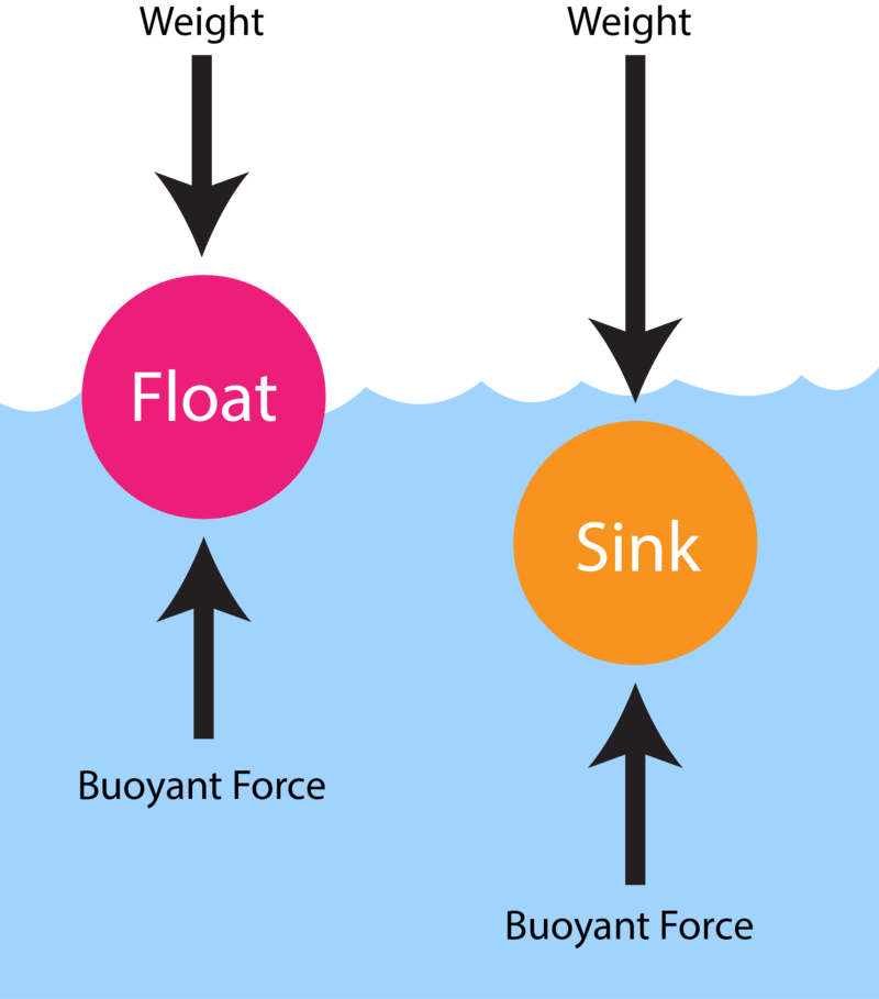
    • What is it: It is the upward force exerted by a fluid (e.g., water) on an object submerged in it.
      • It determines whether an object floats, sinks, or stays suspended.
    • Buoyancy in Oceans: It depends on density differences in water.
      • Lighter water above → unstable → mixing happens.
      • Heavier water above → stable → mixing stops.
    • Buoyancy Flux: Measures changes in buoyancy at the ocean surface over time.
      • Freshwater from rain → makes surface lighter → positive flux → promotes mixing.
      • Heat loss → cools surface → makes water denser → negative flux → resists mixing.

    Key Findings of the Study:

    • Light Rain (0.2–4 mm/hr): Often leads to positive buoyancy flux → supports ocean mixing.
    • Heavy Rain:
      • Usually results in negative buoyancy flux → surface becomes stable.
      • Caused by cold pools that enhance heat loss.
    • Day vs. Night Effect:
      • Night: Rain destabilizes surface → mixing increases.
      • Day: Rain promotes stability → due to added heat loss from sunlight blockage.
    • Geographical Insights:
      • Cold Rain Zones (Western Pacific, Indian Ocean): More stabilization.
      • Hot Rain Zones (Central Pacific): More prone to mixing.

    Significance of the Study

    • Scientific Implications:
      • Refutes the general belief that rain always increases buoyancy.
      • Shows rain can both stabilize or destabilize the ocean surface depending on conditions.
    • Climate Relevance:
      • Ocean mixing is key to heat, carbon, and nutrient cycling.
      • Misreading rainfall’s role can skew climate and weather models.
    • Practical Impact:
      • Improves forecasting accuracy in oceanography and climate science.
      • Aids in understanding the climate-ocean feedback loop more precisely.
    [UPSC 2020] With reference to Ocean Mean Temperature (OMT), which of the following statements is/are correct?

    1. OMT is measured up to a depth of 26°C isotherm which is 129 meters in the southwestern Indian Ocean during January — March.

    2. OMT collected during January — March can be used in assessing whether the amount of rainfall in monsoon will be less or more than a certain long-term mean.

    Select the correct answer using the code given below:

    Options: (a) 1 only (b) 2 only* (c) Both 1 and 2 (d) Neither 1 nor 2


  • Who are Denotified, Semi-Nomadic and Nomadic Tribes (DNTs)?

    Why in the News?

    At an event in New Delhi, Denotified, Semi-Nomadic and Nomadic Tribes (DNTs) strongly demanded a permanent National Commission to address their long-standing marginalisation.

    Who are Denotified, Nomadic, and Semi-Nomadic Tribes (DNTs)?

    • Denotified Tribes (DNTs):
      • Colonial Tag: Branded “criminal by birth” under the Criminal Tribes Act, 1871.
      • Legal Reversal: Act repealed in 1949; tribes de-notified in 1952.
      • Persistent Stigma: Continue to face police profiling and social exclusion.
    • Nomadic Tribes (NTs):
      • Lifestyle: No fixed habitation; move cyclically for livelihood.
      • Occupations: Animal herding, salt trading, performing arts, traditional healing.
    • Semi-Nomadic Tribes (SNTs):
      • Hybrid Living: Alternate between mobile and semi-settled life.
      • Movement: Shift seasonally but often retain a base settlement.

    Current Status in India:

    • Population Share: Around 10% of India’s population.
    • Communities: ~150+ Denotified, 500+ Nomadic tribes.
    • Major States: Maharashtra, Rajasthan, Gujarat, Karnataka, Andhra Pradesh, Uttar Pradesh, Uttarakhand, Bihar, Madhya Pradesh.
    • Examples of Communities (not exhaustive):
      • Denotified: Bedia, Pardhi, Sansi, Kanjar, Lodha, Nat, Chhara, Bhantu
      • Nomadic: Banjara, Gadia Lohar, Rabari, Madari, Kalbelia, Nat
      • Semi-Nomadic: Abor, Adi, Aka, Apatani, Dafla, Galo, Nishi, Tagin

    Major Committees & Commissions:

    Year Contribution
    Criminal Tribes Inquiry Committee 1947 Criticized criminal branding
    Ayyangar Committee 1949 Led to repeal of Criminal Tribes Act
    Kaka Kalelkar Commission 1953 Recognized DNTs, no full classification
    B.P. Mandal Commission 1980 Suggested NTs for OBC list
    Constitution Review Commission 2002 Urged protective measures for DNTs
    Renke Commission 2008 Listed 500+ communities, lacked implementation resources
    Idate Commission 2017–2018 Listed 1,200+, proposed permanent commission


    [UPSC 2019] Consider the following statements about Particularly Vulnerable Tribal Groups (PVTGs) in India:

    1. PVTGs reside in 18 States and one Union Territory. 2. A stagnant or declining population is one of the criteria for determining PVTG status.

    3. There are 95 PVTGs officially notified in the country so far. 4. Irular and Konda Reddi tribes are included in the list of PVTGs.

    Which of the statements given above are correct?

    Options: (a) 1, 2 and 3 (b) 2, 3 and 4 (c) 1, 2 and 4* (d) 1, 3 and 4