The Bhuvan Panchayat V 3.0 web portal was recently launched.
Bhuvan Panchayat Version 3.0
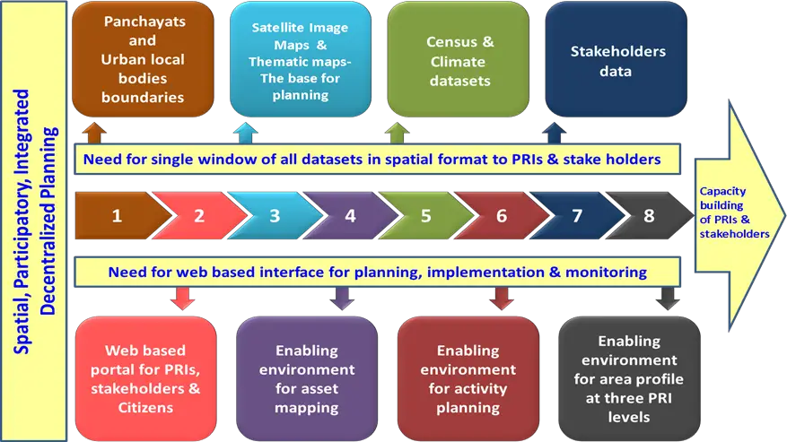
- For better planning and monitoring of government projects, the ISRO has launched the Bhuvan Panchayat web portal’s version 3.0.
- For the first time, a thematic data base on a 1:1000 scale for the entire country is available with integrated high resolution satellite data for planning.
- In the project that will last for at least two years, ISRO will collaborate with the gram panchayat members and stakeholders to understand their data requirements.
- The third version of the portal will provide database visualisation and services for the benefit of panchayat members, among others.
- The project is meant to provide geo-spatial services to aid gram panchayat development planning process of the Ministry of Panchayati Raj.
- The targeted audiences for this portal are Public, PRIs and different stakeholders belonging to the gram panchayats.
About SISDP Project
- Space based Information Support for Decentralised Planning at Panchyayat level (SIS-DP) is a national initiative of preparing basic spatial layers useful in planning process for local self governance.
- ISRO launched SISDP project to assist Gram Panchayats at grassroot level with basic planning inputs derived from satellite data for preparing developmental plans, its implementation and monitoring the activities.
- The National Remote Sensing Centre (NRSC) is the lead centre to execute the project in collaboration with various State Remote Sensing Centres.
- SISDP phase I Project was successfully concluded in the year 2016-17.
- Under Phase II, this project shall be implemented shortly with a enhanced scope of updating geodatabase with latest high resolution remote sensing data and spatial data analytics.
- For the first time, thematic database on 1:10,000 scale for the entire country is available with high integrated High Resolution satellite data for planning.