Dear Aspirants,
This Spotlight is a part of our Mission Nikaalo Prelims-2023.
You can check the broad timetable of Nikaalo Prelims here
Session Details
YouTube LIVE with Parth sir – 7 PM – Prelims Spotlight Session
Evening 04 PM – Daily Mini Tests
Join our Official telegram channel for Study material and Daily Sessions Here
12th Apr 2023
Soils of India
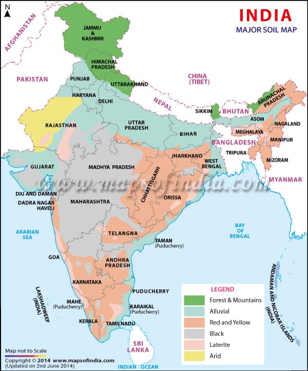
1. Alluvial Soils
- Formation: They are mainly derived from the debris brought down from the Himalayas or the silt left out by the retreating sea. Thus they are azonal soils.
- Areas: Alluvial soils are widespread in the northern plains and the river valleys. Through a narrow corridor in Rajasthan, they extend into the plains of Gujarat. In the Peninsular region, they are found in deltas of the east coast and in the river valleys.
- Soil texture: The alluvial soils vary in nature from sandy loam to clay. These soils are more loamy and clayey in the lower and middle Ganga plain and the Brahmaputra valley. The sand content decreases from the west to east.
- Soil Colour: The colour of the alluvial soils varies from the light grey to ash grey depending on the depth of the deposition, the texture of the materials, and the time taken for attaining maturity.
- Other Characteristic Features:
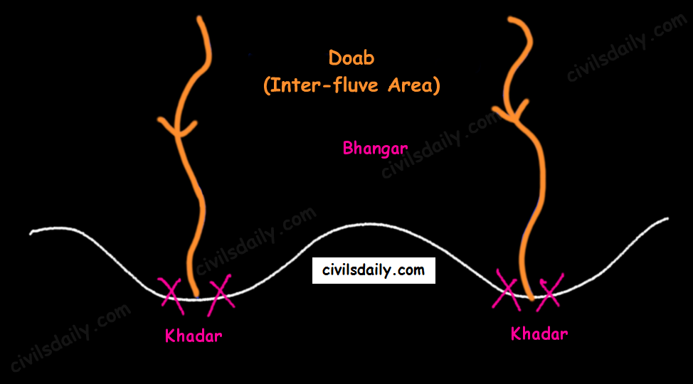
- In the Upper and Middle Ganga plain, two different types of alluvial soils have developed, viz. Khadar and Bhangar.
-
- Khadar: the newer alluvium deposited by floods annually, enriches the soil by depositing fine silts, light colour, found near river beds, porous in nature. Bhangar: older alluvium, clayey, darker, has lime nodules called Kankars, found in doabs (inter-fluve areas).
- Alluvial soils of the northern plains —> transported soils —>, therefore, lack humus —> lack nitrogen [That is why we need to use nitrogenous fertilisers in the northern plains!]. Exception: the Ganga-Brahmaputra delta region is rich in humus.
- These soils lack in nitrogen, phosphorus and humus. However, they are generally rich in potash and lime.
- The soil profile has no stratification.
- Alluvial soils are intensively cultivated.
- In certain areas, these soils are covered with unproductive wind-borne soil called Loess.
- Limitations:
- Allow water to sink into lower strata, and
- Lack nitrogen (But these soils are capable of fixing nitrogen very rapidly through leguminous crops (peas, beans, cloves etc.)
- Suitable Crops: Wheat, rice, maize, sugarcane, pulses, oilseeds, fruits and vegetables, leguminous crops.
2. Black Soil
- These soils are locally known as the ‘Regur Soil’ or the ‘Black Cotton Soil’. Internationally, these are known as ‘tropical chernozems’. These soils are famous for the cultivation of cotton.
- Formation: These have mainly formed from the Deccan Trap rocks —> Zonal Soils
- Areas: These are found in the Deccan trap region. Black soil covers most of the Deccan Plateau which include parts of:
- Maharashtra,
- Madhya Pradesh,
- Gujarat,
- Andhra Pradesh and some parts of
- Tamil Nadu.
- Soil Texture: Black cotton soil (regur soil) is highly argillaceous i.e. clayey. It is deep and impermeable and thus has high water retention capacity.
- Soil Colour: These soils are black in colour due to the presence of iron, aluminium compounds and humus.
- Other Characteristic Features:
- These soils are rich in minerals and known for their fertility.
- The soil depth varies from place to place. It is very thick in lowlands but very thin on highlands. Also, in the upper reaches of the Godavari and the Krishna, and the northwestern part of the Deccan Plateau, the black soil is very deep.
- These soils swell and become sticky when wet and develop deep wide cracks when dry. This helps in self-aeration, which leads to the absorption of nitrogen from the atmosphere. Thus, there occurs a kind of ‘self ploughing’. This aeration and oxidisation to deep levels contribute to the maintenance of the fertility of these soils. This continued fertility is favourable in the area of low rainfall for cotton cultivation even without irrigation.
- Due to slow absorption and loss of moisture, the black soil retains the moisture for a very long time, which helps the crops, especially, the rain-fed ones, to sustain even during the dry season.
- Chemically, the black soils are rich in lime, iron, magnesia and alumina. They also contain potash. But they lack in phosphorous, nitrogen and organic matter.
- Suitable Crops: These soils are highly productive and well suited to the cultivation of cotton, pulses, millets, linseed, tobacco, sugarcane, vegetables and citrus fruits.
Note: In the southern and eastern parts of the country where rainfall is heavy, black soils often occur in close proximity to red soils. Black soils occupy valleys and low-level areas whereas the red soils occur on higher slopes and hilltops. Mixed black and red soils occur in Coimbatore, Madurai, Tirunelveli (Tamil Nadu) and Bundelkhand region.
3. Red and Yellow Soils
- Locally called ‘Chalka’ in Andhra Pradesh.
- Formation: These are derived from granites, gneisses and other metamorphic rocks —> Zonal Soils. These are formed under well-drained conditions.
- Areas: Along the piedmont zone of the Western Ghat, a long stretch of area is occupied by red loamy soil. Yellow and red soils are also found in parts of Orissa and Chattisgarh and in the southern parts of the middle Ganga plain. They encircle the black cotton soil zone.
- Soil Colour: The soil develops a reddish colour due to a wide diffusion of iron in crystalline and metamorphic rocks. It looks yellow when it occurs in a hydrated form. Often, their upper layer is red and the lower layer is yellow.
- Soil Texture: Varies from sand to clay and loam.
- Other Characteristic Features:
- The fine-grained red and yellow soils are normally fertile, whereas coarse-grained soils found in dry upland areas are poor in fertility.
- Have a porous and friable structure.
- They are generally poor in nitrogen, phosphorous and humus.
- These soils are airy and need irrigation for cultivation.
- Intense leaching is a menace in these soil areas.
- Suitable Crops: In places where irrigation facilities are available, the crops cultivated are wheat, cotton, pulses, tobacco, millets, oilseeds, potato, maize, groundnut and orchards.
4. Laterite Soil
- The word laterite has been derived from the Latin word ‘Later’ which means brick. These soils when wet are as soft as butter but become hard and cloddy on drying. Therefore, these are widely cut as bricks for use in house construction.
- Formation: The lateritic soils are particularly found on high flat erosion surfaces in areas of high(>200cm) and seasonal rainfall. The alternating wet and dry seasons lead to the leaching away of the siliceous matter of the rocks leaving behind the compounds of iron and aluminium. These are zonal soils.
- Areas: These soils have mainly developed in the higher areas of the Peninsular plateau. The laterite soils are commonly found in Karnataka, Kerala, Tamil Nadu, Madhya Pradesh and the hilly areas of Orissa and Assam.
- Soil Colour: Reddish-brown in colour due to the presence of iron oxide.
- Other characteristic features:
- With rain, lime and silica are leached away, and soils rich in iron oxide and aluminium compound are left behind(thus the reddish-brown colour). Also, the humus content of the soil is removed fast by bacteria that thrive well in high temperature.
- These soils represent the end product of decomposition and are generally low in fertility.
- The pebbly crust is the important feature of laterites which is formed due to alteration of wet and dry periods.
- These soils are acidic in character due to leaching. Application of manures and fertilisers is required for making these soils fertile for cultivation.
- These soils are poor in organic matter, nitrogen, phosphate and calcium, while iron oxide and potash are in excess.
- Suitable crops: Red laterite soils in Tamil Nadu, Andhra Pradesh and Kerala are more suitable for tree crops like cashew nut. These soils are also suitable for tea plantations.
We discussed in detail alluvial, black, red and laterite soils. Let’s continue the discussion and move on to the next soil types!
5. Arid Soils
- Formation: These are derived from the disintegration of adjacent rocks and are largely blown from coastal regions and Indus valley.
- Areas: Arid soils are characteristically developed in western Rajasthan, which exhibits characteristic arid topography.
- Soil Colour: Arid soils range from red to brown in colour.
- Soil Texture: They are generally sandy to gravelly in texture and have a high percentage of soluble salts.
- Other characteristic features:
- These are saline in nature. In some areas, the salt content is so high that common salt is obtained by evaporating the saline water.
- Due to the dry climate, high temperature and accelerated evaporation, they lack moisture and humus.
- These soils are deficient in nitrogen and humus. The phosphate and iron content is normal. These soils are rich in minerals but the main limitation is the lack of water.
- The soils exhibit poorly developed horizons.
- Plants are widely spaced.
- Chemical weathering is limited.
- Lower horizons of the soil are occupied by ‘kankar’ layers because of the increasing calcium content downwards. The ‘Kankar’ layer formation in the bottom horizons restricts the infiltration of water, and as such when irrigation is made available, the soil moisture is readily available for sustainable plant growth.
- Suitable crops: If irrigated these soils give high agricultural returns. The availability of water from the Indira Gandhi canal has transformed the agricultural landscape of desert soils of western Rajasthan. These soils are mainly devoted to bajra, pulses, guar, fodder and less water requiring crops.
6. Saline and Alkaline Soils
- They are also known as Usara soils. Various local names for saline soils are Reh, Kallar, and Chopan, Rakar, Thur, Karl etc.
- Formation:
- These soils have developed in areas with dry climatic conditions (in areas having a little more rainfall than the areas of desert soils) accompanied by lack of proper drainage. In this situation, salts of sodium, calcium and magnesium are deposited on the upper layer of the soil by capillary action.
- In the Rann of Kuchchh, the Southwest Monsoon brings salt particles and deposits there as a crust.
- These soils are also formed when saline water spreads on the land at the time of high tide in coastal areas. Also, seawater intrusions in the deltas promote the occurrence of saline soils.
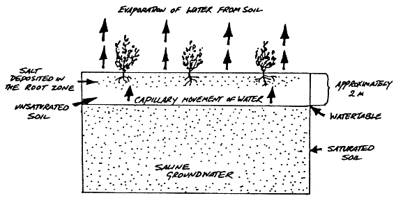
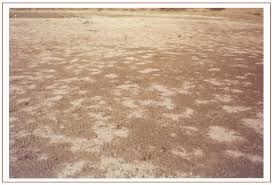
- Salinization also occurs because of over-irrigation (canal irrigation/groundwater use) and in areas of the high water table (as in the coastal areas of Maharashtra and Tamil Nadu). Salinity from irrigation can occur over time wherever irrigation occurs. This is because almost all water (even natural rainfall) contains some dissolved salts. When the plants use the water, the salts are left behind in the soil and eventually begin to accumulate. Also, excessive irrigation with dry climatic conditions promotes capillary action, which results in the deposition of salt on the top layer of the soil (See the following figure).

- These are thus, intrazonal soils.
- These soils have developed in areas with dry climatic conditions (in areas having a little more rainfall than the areas of desert soils) accompanied by lack of proper drainage. In this situation, salts of sodium, calcium and magnesium are deposited on the upper layer of the soil by capillary action.
- Areas: They occur in arid and semi-arid regions, and in waterlogged and swampy areas. These are more widespread in western Gujarat, deltas of the eastern coast and in Sunderban areas of West Bengal.
- Soil Texture: Their texture ranges from sandy to loamy.
- Other characteristic features:
- Because of capillary action, the salts are sucked up in solution to the surface and form white encrustations on the surface (See the picture below).
- The salt efflorescence of calcium, magnesium and sodium makes these soils infertile.
- Saline soils contain an excess of neutral soluble salts of chlorides and sulphates whereas sodic or alkali soils contain sodium carbonates/ sodium bicarbonates.
- They lack in nitrogen and calcium and have low water-bearing capacity.
- These soils can be reclaimed by improving drainage, by applying gypsum and/or lime, and by cultivating salt-resistant crops like barseem, dhaincha and other leguminous crops.
- The saline and alkaline soils may occur in any group of soils.
- Because of capillary action, the salts are sucked up in solution to the surface and form white encrustations on the surface (See the picture below).
- Crops grown: In coastal areas, coconut trees are found in plenty in these soils. As discussed above, cultivating salt-resistant crops like bar seem, dhaincha and other leguminous crops can help in reclaiming these soils.
- Note: In the areas of intensive cultivation with excessive use of irrigation, especially in areas of green revolution, the fertile alluvial soils are becoming saline. In such areas, especially in Punjab and Haryana, farmers are advised to add gypsum to solve the problem of salinity in the soil.
7. Peaty Soils
- These soils are locally called Kari in Kottayam and Alleppey districts of Kerala.
- Formation: These are marshy soils and are a result of waterlogging and anaerobic conditions (which leads to partial decomposition of organic matter).
- Areas: They are found in the areas of heavy rainfall and high humidity, where there is a good growth of vegetation. It occurs widely in the northern part of Bihar, the southern part of Uttaranchal and the coastal areas of West Bengal, Orissa and Tamil Nadu.
- Soil Colour and Texture: These soils are normally heavy and black in colour
- Other characteristic features:
- These soils are characterised by a rich humus and organic content.
- There is a presence of iron and varying amounts of organic matter (10-40%). The organic matter in these soils may go even up to 40-50 per cent.
- These soils are generally acidic in nature. But at many places, they are alkaline also.
- Suitable crops: These are generally submerged during the rainy season and utilised for the cultivation of rice.
8. Forest Soils
- Formation: As the name suggests, forest soils are formed in the forest areas where sufficient rainfall is available.
- Areas: These are found in the forest areas of Himalayas, Sahyadris, Eastern Ghats and terai region.
- Soil colour and texture: The soils vary in structure and texture depending on the mountain environment where they are formed. They are loamy and silty on valley sides and coarse-grained in the upper slopes. Their colour is dark brown.
- Other Characteristics:
- In the snow-bound areas of the Himalayas, they are acidic with low humus content. This is because humus is rawer at higher levels. Also, these soils are subjected to denudation due to landslides and snowfall.
- The soils found in the lower valleys are fertile and rich in organic content.
- Owing to sharp differences of hill slopes and climates, these soils may differ greatly even when in proximity. [Recall here the discussion on the impact of topography on soils!]
- Also, these soils exist in thin layers because of their development on the mountain slopes.
- These soils are poor in potash, phosphorus and lime.
- Soil erosion is a major problem in these areas.
- Crops grown: The slopes are used for horticulture and plantations crops like tea, coffee, spices, apple, peach etc. Rice and wheat are grown in valleys. Potatoes are grown in mostly all areas.
Drainage
The flow of water through well-defined channels is known as ‘drainage’ and the network of such channels is called a ‘drainage system’.
Discordant drainage
A pattern of drainage that bears no relation to the structure of the underlying rock. This may be because:
1. The drainage pattern developed on rock strata that have since been removed by erosion; a process known as superimposition. The drainage pattern thus developed is called superimposed drainage (or Epigenetic or Superinduced Drainage). Examples: The Damodar, the Subarnarekha, the Chambal, the Banas and the rivers flowing at the Rewa Plateau, rivers of eastern USA and southern France.
2. The drainage pattern was already present before a period of uplift and folding that formed the present structure. As the uplift took place, the rivers were able to cut down at approximately the same rate and so maintain their courses. This process is called antecedence and the drainage system thus developed is called antecedent drainage.
Many of the Himalayan rivers have antecedent origin i.e. these rivers existed even before the Himalayan ranges were uplifted. These rivers originate in the Tibetan side beyond the mountain ranges of Himalayas. The Indus, Satluj, Alaknanda, Gandak, Kosi, Brahmaputra all have an antecedent origin. Since these rivers are antecedent, they run transverse to the mountain ranges cutting deep V-shaped, steep-sided valleys (deep gorges).
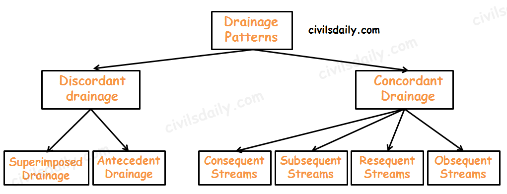
Concordant Drainage (also called accordant drainage)
The pattern of drainage which arises from and closely follows the trends of the underlying strata is called concordant drainage.
- Consequent Streams: Those streams whose courses are the direct consequence of the initial topography are called consequent streams.
- Subsequent Streams: These are developed after the master consequent.
- Obsequent streams: These flow in opposite direction to the master consequent.
- Resequent Streams: A resequent stream flows in the same direction as that of the initial consequent stream, but which develops in response to a new base level formed due to inversion of relief.
Drainage pattern:
Drainage pattern refers to a design which a river and its tributaries form together from its source to its mouth. The drainage pattern of an area is the outcome of:
- The geological time period,
- Nature and structure of rocks,
- Topography,
- Slope,
- Amount of water flowing, and
- The periodicity of the flow.
Some Important Drainage Patterns:
A combination of several patterns may be found in the same drainage basin.
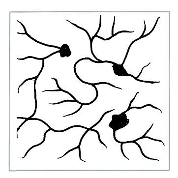
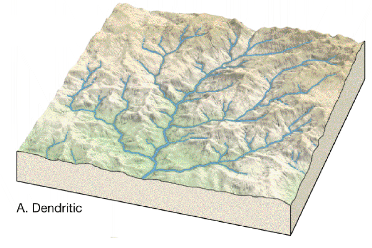
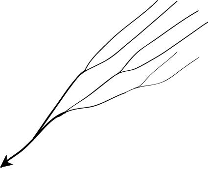
1. Dendritic: The dendritic pattern develops where the river channel follows the slope of the terrain. The drainage pattern resembling the branches of a tree is known as “dendritic” the examples of which are the rivers of northern plain. It is the most common stream pattern. A dendritic pattern develops in a terrain which has uniform lithology, and where faulting and jointing are insignificant.
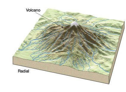
2. Radial: The radial pattern develops when streams flow in different directions from a central peak or a dome-like structure. E.g. the rivers like the Narmada, Son and Mahanadi originating from Maikal Hills flow in different directions and are good examples of a radial pattern.
Radial drainage patterns are also found/in the Girnar Hills (Kathiwar, Gujarat), and Mikir Hills of Assam.
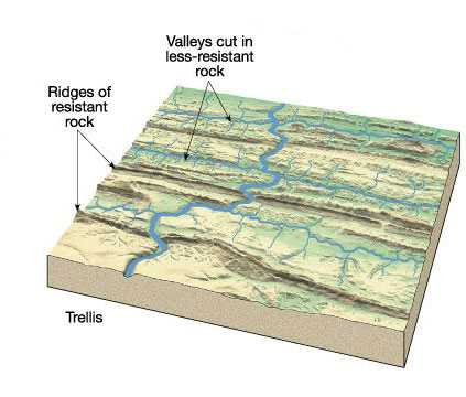
3. Trellis: When the primary tributaries of rivers flow parallel to each other and secondary tributaries join them at right angles, the pattern is known as ‘trellis’. A trellis drainage pattern develops where hard and soft rocks lie parallel to each other. For example, rivers in the upper part of the Himalayan region and in the old folded mountains of the Singhbhum (Chotanagpur Plateau) have drainage of trellis pattern. The trellis drainage pattern can also be seen in the Appalachian region of the U.S.A., where hard and soft rocks occur in parallel bands.
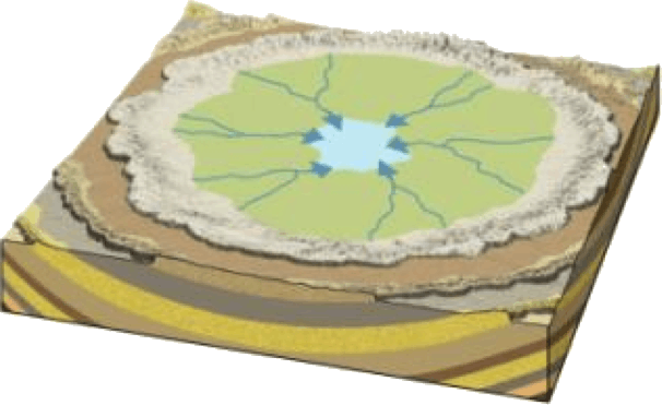
4. Centripetal: When the rivers discharge their waters from all directions in a lake or depression, the pattern is known as ‘centripetal’. This drainage pattern is also called endorheic drainage. For example, Loktak lake in Manipur.
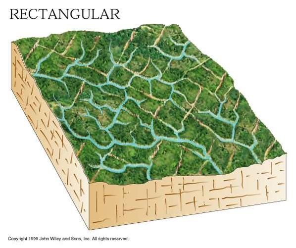
5. Rectangular: In this drainage, both the main stream and its tributaries show right-angled bends. A rectangular drainage pattern develops on a strongly jointed rocky terrain. It differs from trellis pattern drainage, since it is more irregular and its tributary streams are not as long or as parallel as in trellis drainage. Example: Colorado river (USA), streams found is the Vindhyan Mountains of India.
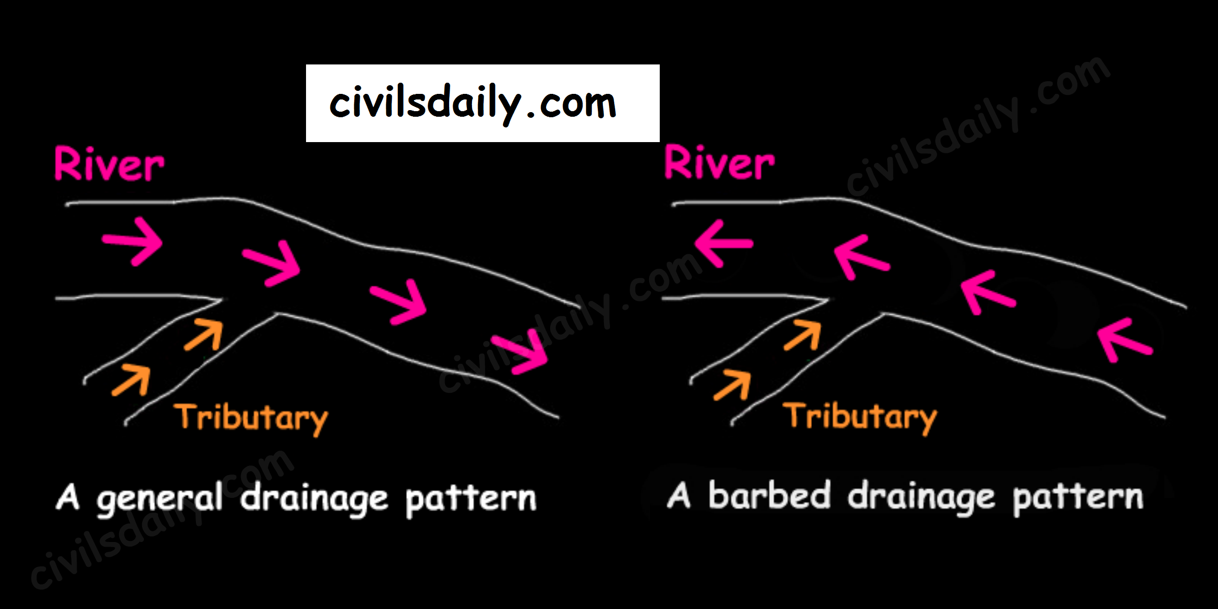
6. Barbed: If you look at the way that tributaries empty into larger rivers, you will notice that most of them flow in the same direction as the rivers they empty into. But quite a large number flow the other way. In fact, you will find stretches of some rivers where every tributary empties into the river in the “wrong” direction! Such an occurrence is known as a barbed drainage pattern.
Most barbed drainage patterns are the result of river-capture which reverses the direction of flow. However, the tributary channels continue to flow in their original direction.
The Arun River (Nepal), a tributary of the Kosi is an interesting example of barbed drainage pattern.
7. Annular: Annular pattern represents that part of a drainage pattern in which the subsequent streams follow the curving or arcuate courses before joining the consequent stream. These results from a partial adaptation to an underground circular structure i.e. batholiths. This is not a very common drainage pattern in India. Some examples of this are however found in Pithoragarh (Uttarakhand), Nilgiri Hills in Tamil Nadu and Kerala.

8. Parallel drainage: The drainage pattern in which the rivers flow almost parallel to each other is known as parallel drainage. The small and swift rivers originating in the Western Ghats and discharging their water into the Arabian Sea provide a good example of parallel drainage pattern in India.
9. Deranged pattern: This is an uncoordinated pattern of drainage characteristic of a region recently vacated by an ice-sheet. The picture is one of numerous water courses, lakes and marshes; some inter-connected and some in local drainage basins of their own. This type of drainage is found in the glaciated valleys of Karakoram.