💥Join UPSC 2027,2028 Mentorship (July Batch) + XFactor Notes & Microthemes PDF

Subject: Environment

  • [pib] Leopard Population in India

    The Ministry of Environment, Forest and Climate Change has released the Status of Leopards Report.

    Confused over Leopard and Cheetah?

    The most common difference between these two animals is the patterns on their coat. At first glance, it may look like they both have spots, but in actual fact, a leopard has rosettes which are rose-like markings, and cheetahs have a solid round or oval spot shape.

    Indian Leopards

    • The Indian leopard (Panthera pardus fusca) is a leopard subspecies widely distributed on the Indian subcontinent.
    • It is one of the big cats occurring on the Indian subcontinent, apart from the Asiatic lion, Bengal tiger, snow leopard and clouded leopard.
    • It is listed as Vulnerable on the IUCN Red List because populations have declined following habitat loss and fragmentation, poaching for the illegal trade of skins and body parts.

    Leopards in India

    • India now has 12,852 leopards as compared to the previous estimate of 7910 conducted 2014.
    • More than 60% increase in population has been recorded.
    • The States of Madhya Pradesh, Karnataka and Maharashtra recorded the highest leopard estimates at 3,421, 1,783 and 1,690 respectively.
    • India’s world record tiger survey also estimated the population of leopards and the tiger range was found a home to 12,852 (12,172-13,535) leopards.

    Significance

    • The increase in Tiger, Lion & Leopards numbers over the last few years is a testimony to the conservation efforts and of the fledgeling wildlife & biodiversity of the country.

  • Species in news: Himalayan trillium

    The Himalayan trillium (Trillium govanianum), a common herb of the Himalayas was declared ‘endangered’ by the International Union for Conservation of Nature (IUCN) last week.

    Try this MCQ:

    Q.Recently, there was a growing awareness in our country about the importance of Himalayan nettle (Girardinia diversifolia) because it is found to be a sustainable source of-

    (a) Anti-malarial drug

    (b) Bio-diesel

    (c) Pulp for paper industry

    (d) Textile fibre

    Himalayan trillium

    • In recent years, the plant has become one of the most traded commercial plants of the Himalayan region, due to its high medicinal quality.
    • It is found in temperate and sub-alpine zones of the Himalayas, at an altitude from 2,400-4,000 metres above sea level.
    • Their existence has also been traced across India, Bhutan, Nepal, China, Afghanistan and Pakistan.
    • In India, it is found in four states only- Himachal Pradesh, Jammu and Kashmir, Sikkim, and Uttarakhand.
    • Often called Nagchatri, in local areas this herb grows to a height of 15-20 cm.

    Various applications

    • It has been used in traditional medicine to cure diseases like dysentery, wounds, skin boils, inflammation, sepsis, as well as menstrual and sexual disorders.
    • Recent experiments have shown that the rhizome of the herb is a source of steroidal saponins and can be used as an anti-cancer and anti-ageing agent.
    • This increased its market value and has now become an easy target for poachers.
  • Converting waste to energy

    The new plant at Bidadi has several advantages but also some operational challenges.

    Practice Question: Discuss the various benefits of waste to energy plants and challenges in running them successfully.

    The prospectus of new plant

    • The new 5 MW waste-to-energy plant is going to set up near Bidadi, Karnataka.
    • This plant is expected to process 600 tonnes per day of inorganic waste.
    • The inorganic waste, which consists of bad quality plastics and used cloth pieces, can be processed as Refuse Derived Fuel (RDF). This material has a calorific value of more than 2,500 kJ/kg.
    • This can be used to generate steam energy, which can be converted into electric energy.

    A well-planned plant

    • The waste-to-energy plants usually accept the RDF material generated in organic composting plants.
    • They also segregate the wet and inorganic material near the plant, convert organic waste to compost, and inorganic waste to energy.
    • About 50 tonnes of RDF generate 1 MW of power, which indicates that the plant at Bidadi has been appropriately designed.

    A permanent solution

    • Handling inorganic waste that is not fit for recycling has always been a challenge.
    • At present, these high-calorific materials are landfilled or left unhandled in waste plants and cause fire accidents.
    • Attempts to send this material to cement kilns have not fructified.
    • The proposed plant can source 600 tonnes per day of this RDF and generate 11.5 MW of power equivalent to 2.4 lakh units of power per day.
    • This will reduce the dependence on unscientific landfills, reduce fire accidents, and provide a permanent solution to recover value from inorganic waste.

    Challenges

    • Needed a good demonstration model – Over the last decade, several Indian cities have been trying to set up such plants but a good demonstration model is yet to be established.
    • Nature of waste – Technology suppliers are international organizations who struggle with the change in quality and nature of waste generated in Indian cities. A few plants in India have stopped operations for this reason.
    • The plants require fine inorganic material with less than 5% moisture and less than 5% silt and soil contents, whereas the moisture and inert content in the mixed waste generated is more than 15%-20%.
    • The sticky silt and soil particles can also reduce the calorific value.
    • Economic cost per unit of electricity – The other big challenge for this plant is the power tariff which is around ₹7-8 KwH which is higher than the ₹3-4 per KwH generated through coal and other means.

    Way forward

    • For the successful running, the plant needs to ease the challenge of handling inorganic waste, the efficiency of organic waste processing/ composting plants.
    • With the increasing waste generation in the coming years, there is a need for more such plants which are environment friendly. 

    Back2Basics: Refuse-derived fuel (RDF)

    • Refuse-derived fuel (RDF) is a fuel produced from various types of waste such as municipal solid waste (MSW), industrial waste or commercial waste.
    • It is selected waste and by-products with recoverable calorific value can be used as fuels in a cement kiln, replacing a portion of conventional fossil fuels, like coal, if they meet strict specifications.
    • Sometimes they can only be used after pre-processing to provide ‘tailor-made’ fuels for the cement process.
    • RDF consists largely of combustible components of such waste, as non-recyclable plastics (not including PVC), paper cardboard, labels, and other corrugated materials.
    • These fractions are separated by different processing steps, such as screening, air classification, ballistic separation, separation of ferrous and non-ferrous materials, glass, stones and other foreign materials and shredding into a uniform grain size, or also pelletized.
    • This produces a homogeneous material which can be used as a substitute for fossil fuels in e.g. cement plants, lime plants, coal-fired power plants or as a reduction agent in steel furnaces.
  • A-68s: Largest floating Iceberg

    A research mission is held to find out the impact of a giant floating iceberg A-68s on the wildlife and marine life on a sub-Antarctic island.

    Q. How does the cryosphere affect global climate? (CSM 2017)

    What are Icebergs?

    • An iceberg is a large piece of freshwater ice that has broken off a glacier or an ice shelf and is floating freely in open (salt) water.
    • Small bits of disintegrating icebergs are called “growlers” or “bergy bits”.
    • Much of an iceberg is below the surface which led to the expression “tip of the iceberg” to illustrate a small part of a larger unseen issue.
    • Icebergs are considered a serious maritime hazard, especially for shipping industries.

    A-68s

    • The iceberg — named A-68s — is travelling at varying speeds depending on local conditions, but at its fastest was travelling about 20 kilometres a day.
    • The huge iceberg — the size of the U.S. state of Delaware — has been floating north since it broke away from Antarctica’s Larsen C ice shelf in 2017.
    • It is now about 75 kilometres from the island of South Georgia, and scientists are concerned over the risks it poses to the wildlife in the area if it grounds near the island.
    • South Georgia is home to colonies of tens of thousands of penguins and 6 million fur seals, which could be threatened by the iceberg during their breeding season.
    • The waters near the island are also one of the world’s largest marine protected areas and house more marine species than the Galapagos.
    • Destruction by the iceberg will release this stored carbon back into the water and, potentially, the atmosphere, which would be a further negative impact.
  • Species in news: Indian bison (Gaur)

    A gaur (Indian bison) strayed into a residential area in Pune city and allegedly died while being captured. This has depicted another ugly face of the man-animal conflicts.

    Try this PYQ:                      

    Q.Which one of the following groups of animals belongs to the category of endangered species?

    (a) Great Indian Bustard, Musk Deer, Red Panda, Asiatic Wild Ass

    (b) Kashmir Stag, Cheetah, Blue Bull, Great Indian Bustard.

    (c) Snow Leopard, Swamp Deer, Rhesus Monkey, Saras (Crane)

    (d) Lion Tailed Macaque, Blue Bull, Hanuman Langur, Cheetah

    Gaur/ Indian Bison

    • The Indian bison are also known as Gaur, is native to South and Southeast Asia and has been listed as Vulnerable on the IUCN Red List since 1986.
    • The global population has been estimated at maximum 21,000 mature individuals by 2016.
    • It declined by more than 70% during the last three generations, and is extinct in Sri Lanka and probably also in Bangladesh.
    • Populations in well-protected areas are stable and increasing.
    • The Western Ghats and their outflanking hills in southern India constitute one of the most extensive extant strongholds of gaur, in particular in the Wayanad – Nagarhole – Mudumalai – Bandipur complex.
  • How to measure a Mountain?

    China and Nepal have announced Mount Everest is 0.86 m taller than the 8,848 m accepted globally so far.

    Try this PYQ:

    Q.When you travel to the Himalayas, you will see the following:

    1. Deep gorges
    2. U-turn river courses
    3. Parallel mountain ranges
    4. Steep gradients causing land-sliding

    Which of the above can be said to be the evidences for the Himalayas being young fold mountains?

    (a) 1 and 2 only

    (b) 1, 2 and 4 only

    (c) 3 and 4 only

    (d) 1, 2, 3 and 4

    Scaling a mountains’ height

    • The basic principle that was used earlier is very simple and uses  only trigonometry which most of us are familiar with, or at least can recall.
    • There are three sides and three angles in any triangle. If we know any three of these quantities, provided one of them is a side, all the others can be calculated.
    • In a right-angled triangle, one of the angles is already known, so if we know any other angle and one of the sides, the others can be found out.
    • This principle can be applied for measuring the height of any object that does not offer the convenience of dropping a measuring tape from top to bottom.

    Accuracy issues

    • For small hills and mountains, whose top can be observed from relatively close distances, this can give quite precise measurements.
    • But for Mount Everest and other high mountains, there are some other complications.
    • These again arise from the fact that we do not know where the base of the mountain is.

    Measuring against sea level

    • Generally, for practical purposes, the heights are measured above mean sea level (MSL). Moreover, we need to find the distance to the mountain.
    • This is done through a painstaking process called high-precision levelling. Starting from the coastline, we calculate step by step the difference in height, using special instruments.
    • This is how we know the height of any city from mean sea level.

    Adjusting gravitation anomaly

    • But there is one additional problem to be contended with — gravity. Gravity is different in different places. It means that even sea level cannot be considered to be uniform at all places.
    • So, the local gravity is also measured to calculate the local sea level. Nowadays sophisticated portable gravitometers are available that can be carried even to mountain peaks.

    Technology solutions

    • These days GPS is widely used to determine coordinates and heights, even of mountains.
    • But, GPS gives precise coordinates of the top of a mountain relative to an ellipsoid which is an imaginary surface mathematically modelled to represent Earth.
    • This surface differs from the mean sea level. Similarly, overhead flying planes equipped with laser beams (LiDAR) can also be used to get the coordinates.

    How accurate are China/Nepal’s apprehensions?

    • Considering that during 1952-1954, when neither GPS and satellite techniques were available nor the sophisticated gravimeters, the task of determining the height of Mount Everest was not easy.
    • Nepal and China have said they have measured Mount Everest to be 86 cm higher than the 8,848 m that it was known to be.
    • But these have been explained in terms of geological processes that might be altering the height of Everest. The accuracy of the 1954 result has never been questioned.
    • Most scientists now believe that the height of Mount Everest is increasing at a very slow rate. This is because of the northward movement of the Indian tectonic plate that is pushing the surface up.
    • Big earthquake, like the one that happened in Nepal in 2015, can alter the heights of mountains. Such events have happened in the past.
  • Species in news: Himalayan Serow

    A Himalayan Serow has been sighted for the first time in the Himalayan cold desert region.

    Try this MCQ:

    Q.In which one of the following State, the Rupi Bhaba Wildlife Sanctuary is located?

    (a) Himachal Pradesh

    (b) Manipur

    (c) Meghalaya

    (d) Uttarakhand

    Himalayan Serow

    • Himalayan Serow resembles a cross between a goat, a donkey, a cow, and a pig.
    • They are herbivores and are typically found at altitudes between 2,000 metres and 4,000 metres (6,500 to 13,000 feet).
    • They are known to be found in eastern, central, and western Himalayas, but not in the Trans Himalayan region.
    • They are a medium-sized mammal with a large head, thick neck, short limbs, long, mule-like ears, and a coat of dark hair.
    • There are several species of Serow s, and all of them are found in Asia.

    Its’ conservation status

    • According to the IUCN, Himalayan Serow s have experienced significant declines in population size, range size and habitat in the last decade, and this is expected to continue due to intensive human impact.
    • Previously assessed as ‘near threatened’, the Himalayan Serow is now been categorised as ‘vulnerablein the IUCN Red List of Threatened Species.
    • It is listed under Schedule I of The Wildlife Protection Act, 1972, which provides absolute protection.

    What is so unusual this time?

    • The animal was spotted by locals and wildlife officials at a riverside rocky wall near Hurling village in Spiti, Himachal Pradesh.
    • This is the first recorded human sighting of the Serow in Himachal Pradesh.
    • Serow s are generally not found at this altitude, and never before has a Serow been seen in the Himalayan cold desert.
    • Wildlife officials believe this particular animal may have strayed into the Spiti valley from the Rupi Bhaba Wildlife Sanctuary in adjoining Kinnaur.
  • Hazardous ideas for the Himalayas

    By planning hydropower projects, India and China are placing the region at great risk.

    China’s new hydropower project

    • Recently China announced that it is planning to build a major hydropower project as a part of its 14th Five-Year Plan (2021-25), on the YarlungZanbo River, in Mêdog County in Tibet.
    • The hydropower generation station is expected to provide 300 billion kWh of electricity annually.
    • The Chinese authorities say the project will help the country realize its goal of reaching a carbon emission peak before 2030 and carbon neutrality before 2060.

    Misadventures

    • Such ‘super’ dams projects are very unviable as they are being planned in an area that is geologically unstable.
    • There are two hydropower projects being built in Arunachal Pradesh on the tributaries of the Brahmaputra: the 600 MW Kameng project on the Bichom and Tenga Rivers and the 2,000 MW Subansiri Lower Hydroelectricity Project.
    • China has already completed 11 out of 55 projects that are planned for the Tibetan region. In this race, the two countries overestimate their economic potential and grossly underestimate the earthquake vulnerability of the region.
    • High seismic zones coincide with areas of high population concentration in the Himalayan region where landslides and glacial lake outburst floods are common.

    Practice Question:‘’Carbon neutrality should not be at the expense of the environment.” Elaborate with proper examples.

    Havocs created due to these earthquakes

    • About 15% of the great earthquakes of the 20th century (with a magnitude of more than 8) occurred in the Himalayan region.
    • The northeast Himalayan band has experienced several large earthquakes of magnitude 7 and above in the last 100 years, more than the share from other parts of the Himalayas.
    • The 1950 earthquake just south of the McMahon Line was of 6 magnitudes. It was the largest continental event ever recorded and devastated Tibet and Assam.
    • The earthquake killed thousands, and caused extensive landslides, widespread land level changes and gaping fissures. It resulted in water and mud oozing in the Himalayan ranges and the upper Assam valley.
    • The earthquake was felt over an extensive area comprising parts of India, Tibet, erstwhile East Pakistan and Myanmar.
    • The2015 Gorkha earthquake of magnitude 7.8 in central Nepal resulted in huge losses in the hydropower sector. Nepal lost about 20% of its hydropower capacity consequent to the earthquake.
    • About 30 projects with a capacity of 270 MW, mostly located along the steep river valleys, were damaged.

    What are the issues of high concern?

    • The main mechanisms that contributed to the vulnerability of hydropower projects were found to be landslides, which depend on the intensity of seismic ground shaking and slope gradients.
    • Heavy siltation from giant landslides expected in the project sites and headwater region from future earthquakes will severely reduce the water-holding capacity and life expectancy of such dams.
    • Even without earthquakes, the steep slopes made of soft rocks are bound to slide due to deforestation and road-building. These activities will get intensified as part of the dam-building initiatives.
    • Desilting of dams is not an economically viable proposition and is technologically challenging.

    A transnational asset under threat

    • The Himalayan range is a transnational mountain chain and is the chief driver of the Asian climate.
    • It is a source for numerous Asian river systems and glaciers which are now under the threat of degradation and retreat due to global warming; these river systems provide water for billions of people.
    • The ongoing low-level military confrontations between these two countries have led to demands for further infrastructural development on both sides, including all-weather roads, much to the peril of regional biodiversity and the livelihoods of the indigenous population.
    • The Himalayas have seen the highest rate of deforestation and land-use changes.

    Way Forward

    • There is a need for India and China to sit together to deliberate on the consequences of such misadventures in an area where massive earthquakes are bound to take place.
    • The upper Himalayas should be converted into a nature reserve by an international agreement.
    • The possibility of a Himalayan River Commission involving all the headwater and downstream countries needs to be explored.
    • There is a need to understand that – ‘’Carbon neutrality should not be at the expense of the environment’’.
  • Shola Sky Islands of the Western Ghats

    Tropical montane grasslands (TMG) in the Shola Sky Islands of the Western Ghats have suffered big losses due to invasions by exotic trees.

    Try this PYQ:

    Q.In India, which type of forest among the following occupies the largest area?
    (a) Montane Wet Temperate Forest
    (b) Sub – tropical Dry Evergreen Forest
    (c) Tropical Moist Deciduous Forest
    (d) Tropical Wet Evergreen Forest

    Sky Islands

    • “Sky islands” are the tops of tall mountains that become environmentally isolated from each other even if they are close together, geographically speaking.
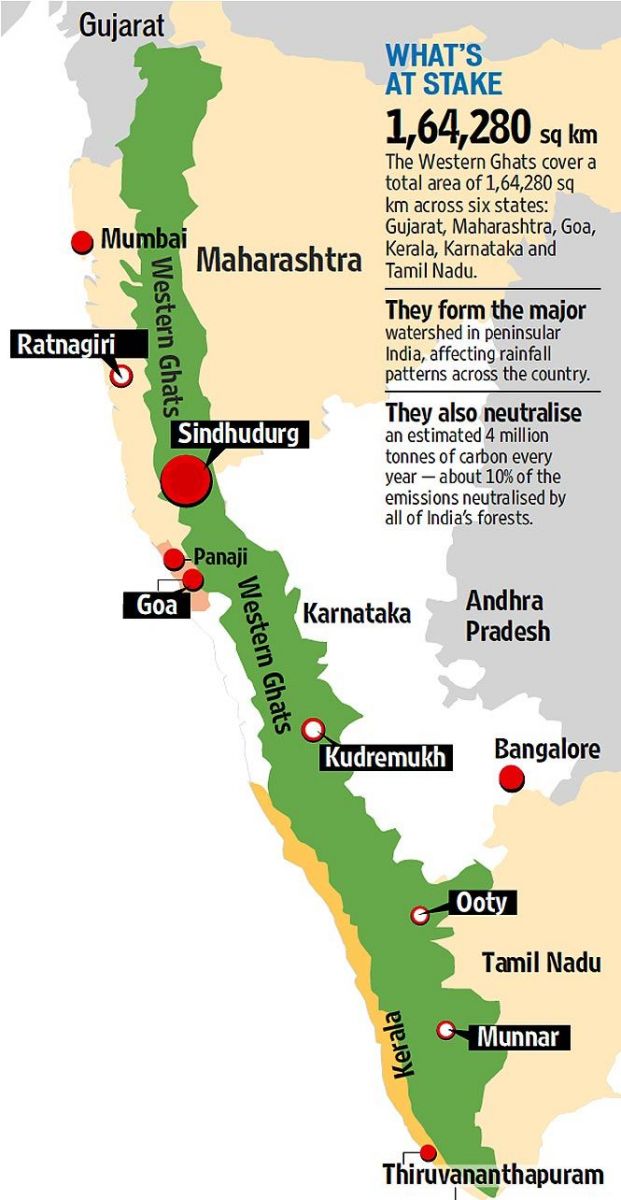
    • The Western Ghats are a mountain chain in southwest India home to spectacular and unique sky islands.
    • The peaks of the Western Ghats, ranging between 3,000 and 8,500 feet above sea level, host an almost unbelievable array of microclimates, looking like “patches of forests floating in a sea of grasslands.

    What are TMGs?

    • TMG are high elevation grasslands forming only 2% of all grasslands in the world.
    • Among their functions is regulating the global carbon cycle and serving as a source of water to downstream communities.
    • Researchers say grasslands do not benefit from conservation and restoration efforts afforded to tropical montane forests, possibly due to limited information.

    Treasures of Shola

    • One of the specific habitats unique to the sky islands of this area is a type of low-temperature, high-humidity tropical cloud forest full of stunted trees mixed with grasslands called the Shola.
    • The Shola forests of South derive their name from the Tamil word solai, which means a ‘tropical rain forest’.
    • Classified as ‘Southern Montane Wet Temperate Forest’ the Sholas are found in the upper reaches of the Nilgiris, Anamalais, Palni hills, Kalakadu, Mundanthurai and Kanyakumari in the states of Tamil Nadu and Kerala.
    • These forests are found sheltered in valleys with sufficient moisture and proper drainage, at an altitude of more than 1,500 metres.

    Various threats to them

    • Loss of grasslands due to invasive exotic trees is a “novel threat” through the establishment and expansion of exotic tree plantations.
    • These exotic trees include acacias, pines and eucalyptus, shrinking the range sizes of endemic species, including plants, birds, amphibians and mammals.
    • In the Western Ghats, 23% of montane grasslands were reportedly converted into invasive exotic tree cover over a period of 44 years.
    • Attempts to manage invasive exotic trees in montane grasslands incorporated approaches that include prevention and mechanical, chemical and biological control.
    • For invasive species such as Acacia mearnsii that grow rapidly and disperse seeds widely, removing mature trees is often ineffective.
  • Species in news: Myristica Swamp Treefrog

    Myristica swamp treefrog, a rare arboreal (living on trees) species endemic to the Western Ghats has been recorded for the first time in Kerala’s Thrissur district.

    Again, a stand-alone peculiar species is in the news. Make a special note here. Usually, note the species and its habitat location (IUCN status if available), in the purview of a generic prelims question.

    Myristica Swamp Treefrog

    • It bears the scientific name Mercurana myristicapalustris.
    • The frog was first spotted in 2013 in the Myristica swamps of Arippa, near the Kulathupuzha Reserve Forest, in the western foothills of Agasthyamalai, in Kollam district.
    • Unlike the Myristica swamp treefrog found in the foothills of the Agasthyamalai, these frogs were found to be active throughout June and early July.

    Unique traits

    • These frogs are rare and elusive for the reason that they are arboreal and active only for a few weeks during their breeding season.
    • During this season, there is a large aggregation of males that descend from the high canopy of the trees.
    • The breeding season, unlike for other frogs, starts in the pre-monsoon season (May) and ends before the monsoon becomes fully active in June.
    • Before the end of the breeding season, the female frogs along with their male counterparts descend on the forest floor. The female digs the mud and lays eggs in shallow burrows in mud.
    • After breeding and egg-laying, they retreat back to the high canopies of the tree and remain elusive till next breeding season.