
Why in News?
Recent flash floods in Himalayan States have brought cloudbursts into focus. The IMD has clarified that many reported “cloudbursts” do not meet its scientific definition, highlighting the need for accurate terminology and better disaster planning.
What is a Cloudburst?
- According to the India Meteorological Department (IMD), a cloudburst is 100 mm (10 cm) or more rainfall in one hour over a 20 to 30 sq. km area.
- Key Features
- Highly localized and short-duration event.
- Causes sudden flash floods and landslides due to rapid runoff.
- Much rarer than normal heavy monsoon rainfall.
- Mini-cloudburst (proposed): Some scientists suggest a category of 50 mm rainfall in one hour over the same area, as it can also cause severe damage.
How Common are Cloudbursts in India?
- Cloudbursts are rare, but their frequency is increasing due to global warming, as warmer air can hold more moisture.
- IMD recorded around 30 cloudbursts between 1970 and 2016, though experts believe many events went unrecorded.
- Most occur in remote Himalayan regions, where monitoring stations are sparse.
- Frequently reported in Uttarakhand, Himachal Pradesh, Jammu & Kashmir, Assam, and the Northeast, especially during July-August.
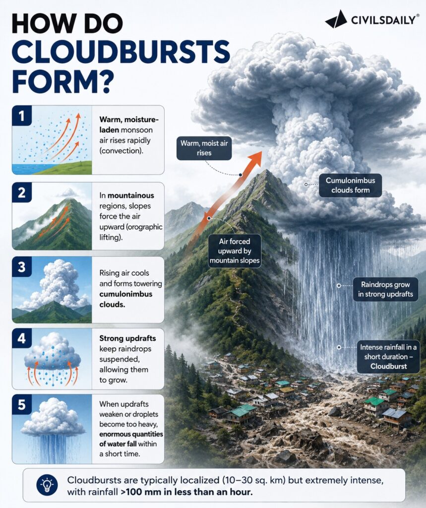
How Do Cloudbursts Form?
Why are Cloudbursts Difficult to Forecast?
- Highly localized, smaller than weather model grid sizes.
- Develop rapidly, leaving very little lead time.
- Mountains block Doppler Weather Radar signals, creating blind spots.
- Limited Automatic Weather Stations (AWS) in high-altitude areas reduce real-time observations.
- Hyperlocal prediction requires high-resolution models and massive computing power.
What is India Doing?
- IMD Nowcasting for short-term weather alerts.
- Mission Mausam to strengthen hyperlocal forecasting.
- Expansion of the Doppler Weather Radar (DWR) network.
- Installation of more Automatic Weather Stations (AWS).
- Use of Artificial Intelligence (AI) for improved weather prediction and early warnings.
Challenges
- Sparse observation network in mountainous terrain.
- Radar blind spots due to topography.
- Limited computing capacity for hyperlocal models.
- Growing climate change-induced extreme rainfall.
- Weak enforcement of land-use regulations.
[2026] Which of the following statements with regard to India’s indigenous new high resolution weather model, the ‘Bharat Forecast System,’ is/are correct?
1. Its objective is to generate forecasts at the Panchayats cluster level.
2. It was developed by IIT Delhi.
Select the answer using the code given below:
[A] 1 only
[B] 2 only
[C] Both 1 and 2
[D] Neither 1 nor 2