💥Join UPSC 2027,2028 Mentorship (July Batch) + XFactor Notes & Microthemes PDF

Author: CD Staff

  • [Burning Issue] National Education Policy – 2020: Higher Education and Regional Languages

    UPSC 2022 countdown has begun! Get your personal guidance plan now! (Click here)

    The National Policy on Education was framed in 1986 and modified in 1992. Since then several changes have taken place that calls for a revision of the Policy.

    The National Education Policy (NEP), 2020 is the first education policy of the 21st century and replaces the thirty-four-year-old National Policy on Education (NPE), 1986. Built on the foundational pillars of Access, Equity, Quality, Affordability, and Accountability, this policy is aligned to the 2030 Agenda for Sustainable Development and aims to transform India into a vibrant knowledge society and global knowledge superpower by making both school and college education more holistic, flexible, multidisciplinary, suited to 21st century needs and aimed at bringing out the unique capabilities of each student.

    Backgrounder: Education Policies in India

    Education Policy lays particular emphasis on the development of the creative potential of each individual. It is based on the principle that education must develop not only cognitive capacities -both the ‘foundational capacities’ of literacy and numeracy and ‘higher-order’ cognitive capacities, such as critical thinking and problem-solving — but also social, ethical, and emotional capacities and dispositions.

    The implementation of previous policies on education has focused largely on issues of access and equity. The unfinished agenda of the National Policy on Education 1986, modified in 1992 (NPE 1986/92), is appropriately dealt with in this Policy. A major development since the last Policy of 1986/92 has been the Right of Children to Free and Compulsory Education Act 2009 which laid down legal underpinnings for achieving universal elementary education.

    Evolution of Education Policy in India

    1. University Education Commission (1948-49)
    2. Secondary Education Commission (1952-53)
    3. Education Commission (1964-66) under Dr D. S. Kothari
    4. National Policy on Education, 1968
    5. 42nd Constitutional Amendment, 1976- Education in Concurrent List
    6. National Policy on Education (NPE), 1986
    7. NPE 1986 Modified in 1992 (Programme of Action, 1992)
    8. S.R. Subrahmanyam Committee Report (May 27, 2016)
    9. K. Kasturirangan Committee Report (May 31, 2019)

    Some of the major path-breaking policies and their features:

    Earlier major Educational Policies (Year)Key Features
    1968Based on the report and recommendations of the Kothari Commission (1964–1966)India’s first National Policy which called for a “radical restructuring” and proposed equal educational opportunities gave the “three-language formula” to be implemented in secondary education
    1986Introduced under Rajiv Gandhi’s Prime Ministership, expected to spend 6% of GDP on education for the 1st timeIt called for “special emphasis on the removal of disparities and to equalize educational opportunity” It called for a “child-centered approach” in primary education and launched “Operation Blackboard“Also called for the creation of the “rural university” model, based on the philosophy of Mahatma Gandhi
    19921986 Policy modified in 1992 by the P.V. Narasimha Rao government laid down a Three – Exam Scheme: JEE/AIEEE/State EEE (Engineering Entrance Exam)

    The National Education Policy, 2020

    • It marks the fourth major policy initiative in education since Independence.
    • The last one has undertaken a good 34 years ago and modified in 1992.
    • Based on two committee reports and extensive nationwide consultations, NEP 2020 is sweeping in its vision and seeks to address the entire gamut of education from preschool to doctoral studies, and from professional degrees to vocational training.

    Salient features of the NEP 2020

    School Education

    (1) Ensuring Universal Access at all levels of school education

    • Ensuring universal access: NEP 2020 emphasizes on ensuring universal access to school education at all levels- preschool to secondary.
    • Bring back dropouts into the mainstream: Infrastructure support, innovative education centers to bring back dropouts into the mainstream, tracking of students and their learning levels, facilitating multiple pathways to learning involving both formal and non-formal education modes, association of counselors or well-trained social workers with schools, open learning for classes 3,5 and 8 through NIOS and State Open Schools, secondary education programs equivalent to Grades 10 and 12, vocational courses, adult literacy and life-enrichment programs are some of the proposed ways for achieving this.
    • About 2 crore out of school children will be brought back into main stream under NEP 2020.

    (2) Early Childhood Care & Education with new Curricular and Pedagogical Structure

    • Emphasis on Early Childhood Care and Education: The 10+2 structure of school curricula is to be replaced by a 5+3+3+4 curricular structure corresponding to ages 3-8, 8-11, 11-14, and 14-18 years respectively.  
    • This will bring the hitherto uncovered age group of 3-6 years under school curriculum, which has been recognized globally as the crucial stage for development of mental faculties of a child.
    • The new system will have 12 years of schooling with three years of Anganwadi/ pre schooling.
    • NCERT will develop a National Curricular and Pedagogical Framework for Early Childhood Care and Education (NCPFECCE) for children up to the age of 8.
    • The planning and implementation of ECCE will be carried out jointly by the Ministries of HRD, Women and Child Development (WCD), Health and Family Welfare (HFW), and Tribal Affairs.

    (3) Attaining Foundational Literacy and Numeracy

    • National Mission on Foundational Literacy and Numeracy: Recognizing Foundational Literacy and Numeracy as an urgent and necessary prerequisite to learning, NEP 2020 calls for setting up of a National Mission on Foundational Literacy and Numeracy by MHRD.
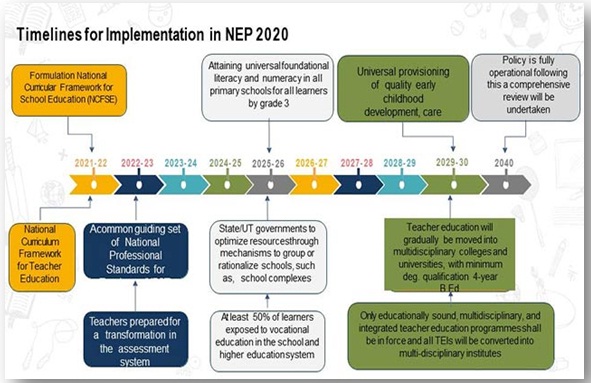
    • States will prepare an implementation plan for attaining universal foundational literacy and numeracy in all primary schools for all learners by grade 3 by 2025.
    • A National Book Promotion Policy is to be formulated.

    (4) Reforms in school curricula and pedagogy

    • Aim: It aims for holistic development of learners by equipping them with the key 21st century skills, reduction in curricular content to enhance essential learning and critical thinking and greater focus on experiential learning.
    • Increased flexibility and choice of subjects with students: There will be no rigid separations between arts and sciences, between curricular and extra-curricular activities, between vocational and academic streams.
    • Vocational education will start in schools from the 6th grade, and will include internships.
    • National Curricular Framework for School Education, NCFSE 2020-21 will be developed by the NCERT.

    (5) Multilingualism and the power of language

    • Emphasis on mother tongue as the medium of instruction: The policy has emphasized mother tongue/local language/regional language as the medium of instruction at least till Grade 5, but preferably till Grade 8 and beyond.
    • Convenience of optional language:
    • Sanskrit to be offered at all levels of school and higher education as an option for students, including in the three-language formula.
    • Other classical languages and literatures of India also to be available as options. No language will be imposed on any student.
    • Students to participate in a fun project/activity on ‘The Languages of India’, sometime in Grades 6-8, such as, under the ‘Ek Bharat Shrestha Bharat’ initiative.
    • Several foreign languages will also be offered at the secondary level.
    • Indian Sign Language (ISL) will be standardized across the country, and National and State curriculum materials developed, for use by students with hearing impairment.

    (6) Assessment Reforms

    • Shift from summative assessment to regular and formative assessment which is more competency-based, promotes learning and development, and tests higher-order skills, such as analysis, critical thinking, and conceptual clarity.
    • Revamping Board Exams: Board exams for Grades 10 and 12 will be continued, but redesigned with holistic development as the aim.
    • A new National Assessment Centre, PARAKH (Performance Assessment, Review, and Analysis of Knowledge for Holistic Development), will be set up as a standard-setting body .

    (7) Equitable and Inclusive Education

    • Ensuring complete coverage: NEP 2020 aims to ensure that no child loses any opportunity to learn and excel because of the circumstances of birth or background.
    • Special emphasis on Socially and Economically Disadvantaged Groups (SEDGs) which include gender, socio-cultural, and geographical identities and disabilities.  
    • Setting up of Gender Inclusion Fund and also Special Education Zones for disadvantaged regions and groups.
    • Enabling disables: Children with disabilities will be enabled to fully participate in the regular schooling process from the foundational stage to higher education.
    • It will be done withwith support of educators with cross disability training, resource centers, accommodations, assistive devices, appropriate technology-based tools and other support mechanisms tailored to suit their needs.
    • Bal Bhavans: Every state/district will be encouraged to establish “Bal Bhavans” as a special daytime boarding school, to participate in art-related, career-related, and play-related activities.
    • Free school infrastructure can be used as Samajik Chetna Kendras.

    (8) Robust Teacher Recruitment and Career Path

    • Robust, transparent processes for teachers’ recruitment: Teachers will be recruited through robust, transparent processes.
    • Merit based promotions with a mechanism for multi-source periodic performance appraisals and available progression paths to become educational administrators or teacher educators.
    • National Professional Standards for Teachers (NPST) will be developed by the National Council for Teacher Education by 2022, in consultation with NCERT, SCERTs, teachers and expert organizations from across levels and regions.

    (9) School Governance

    • Schools can be organized into complexes or clusters which will be the basic unit of governance and ensure availability of all resources including infrastructure, academic libraries and a strong professional teacher community.

    (10) Standard-setting and Accreditation for School Education

    • NEP 2020 envisages clear, separate systems for policy making, regulation, operations and academic matters.  States/UTs will set up independent State School Standards Authority (SSSA).
    • The SCERT will develop a School Quality Assessment and Accreditation Framework (SQAAF) through consultations with all stakeholders.
    Higher Education

    (1) Increase GER to 50 % by 2035

    • NEP 2020 aims to increase the Gross Enrolment Ratio in higher education including vocational education from 26.3% (2018) to 50% by 2035. 3.5 Crore new seats will be added to Higher education institutions.

    (2) Holistic Multidisciplinary Education

    • Broad based multi-disciplinary, holistic UG education with flexible curricula, creative combinations of subjects, integration of vocational education and multiple entry and exit points with appropriate certification.
    • An Academic Bank of Credit is to be established for digitally storing academic credits earned from different HEIs so that these can be transferred and counted towards final degree earned.
    • Multidisciplinary Education and Research Universities (MERUs), at par with IITs, IIMs, to be set up as models of best multidisciplinary education of global standards in the country.
    • The National Research Foundation will be created as an apex body for fostering a strong research culture and building research capacity across higher education.

    (3) Regulation

    • Higher Education Commission of India (HECI) will be set up as a single overarching umbrella body the for entire higher education, excluding medical and legal education.
    • It will function through faceless intervention through technology, & will have powers to penalize HEIs not conforming to norms and standards.
    • Public and private higher education institutions will be governed by the same set of norms for regulation, accreditation and academic standards.

    (4) Rationalized Institutional Architecture

    • Higher education institutions will be transformed into large, well resourced, vibrant multidisciplinary institutions providing high quality teaching, research, and community engagement.
    • The definition of university will allow a spectrum of institutions that range from Research-intensive Universities to Teaching-intensive Universities and Autonomous degree-granting Colleges. 
    • Affiliation of colleges is to be phased out in 15 years and a stage-wise mechanism is to be established for granting graded autonomy to colleges.

    (5) Motivated, Energized, and Capable Faculty

    • Recommendations for motivating, energizing, and building capacity of faculty thorugh clearly defined, independent, transparent recruitment.
    • Freedom to design curricula/pedagogy, incentivizing excellence, movement into institutional leadership.

    (6) Teacher Education

    • National Curriculum Framework for Teacher Education, NCFTE 2021: A new and comprehensive framework will be formulated by the NCTE in consultation with NCERT.
    • By 2030, the minimum degree qualification for teaching will be a 4-year integrated B.Ed. degree.

    (7) Mentoring Mission

    • A National Mission for Mentoring will be established, with a large pool of outstanding senior/retired faculty – including those with the ability to teach in Indian languages – who would be willing to provide short and long-term mentoring/professional support to university/college teachers.

    (8) Financial support for students

    • Efforts will be made to incentivize the merit of students belonging to SC, ST, OBC, and other SEDGs.
    • The National Scholarship Portal will be expanded to support, foster, and track the progress of students receiving scholarships.
    • Private HEIs will be encouraged to offer larger numbers of free ships and scholarships to their students.

    (9) Open and Distance Learning

    • Measures such as online courses and digital repositories, funding for research, improved student services, credit-based recognition of MOOCs, etc., will be taken to ensure it is at par with the highest quality in-class programmes.

    (10) Online Education and Digital Education

    • A dedicated unit for building of digital infrastructure, digital content and capacity building will be created in the MHRD to look after the e-education needs of both school and higher education.

    (11) Technology in education

    • National Educational Technology Forum (NETF): An autonomous body will be created to provide a platform for the free exchange of ideas on the use of technology to enhance learning, assessment, planning, and administration.

    (12) Professional Education

    • All professional education will be an integral part of the higher education system.
    • Stand-alone technical universities, health science universities, legal and agricultural universities etc will aim to become multi-disciplinary institutions.

    (13) Adult Education

    • Policy aims to achieve 100% youth and adult literacy.

    (14) Financing Education

    • The Centre and the States will work together to increase the public investment in Education sector to reach 6% of GDP at the earliest.

    Positive Aspects of Higher Education in Regional Language

    • Subject-Specific Improvement: Several studies in India and other Asian countries suggest a positive impact on learning outcomes for students using a regional medium rather than the English medium.
    • Performance in science and math, in particular, has been found to be better among students studying in their native language compared to English.
    • Higher Rates of Participation: Studying in the native language results in higher attendance, motivation and increased confidence for speaking up among students and improved parental involvement and support in studies due to familiarity with the mother tongue.
    • Additional Benefits for the Less-Advantaged: This is especially relevant for students who are first-generation learners (the first one in their entire generation to go to school and receive an education) or the ones coming from rural areas, who may feel intimidated by unfamiliar concepts in an alien language.
    • Increase in Gross-Enrollment Ratio (GER): This will help provide quality teaching to more students and thus increase Gross Enrolment Ratio (GER) in higher education.
    • Promotes Linguistic Diversity: It will also promote the strength, usage, and vibrancy of all Indian languages.
    • It would also help prevent language-based discrimination.

    Issues with the policy

    1) Lack of integration

    • In both the thinking, and in the document, there are lags, such as the integration of technology and pedagogy.
    • There are big gaps such as lifelong learning, which should have been a key element of upgrading to emerging sciences.

    2) Language barrier

    • There is much in the document ripe for debate – such as language. The NEP seeks to enable home language learning up to class five, in order to improve learning outcomes.
    • Sure, early comprehension of concepts is better in the home language and is critical for future progress. If the foundations are not sound, learning suffers, even with the best of teaching and infrastructure.
    • But it is also true that a core goal of education is social and economic mobility, and the language of mobility in India is English.

    3) Multilingualism debate

    • Home language succeeds in places where the ecosystem extends all the way through higher education and into employment. Without such an ecosystem in place, this may not be good enough.
    • The NEP speaks of multilingualism and that must be emphasised. Most classes in India are de facto bilingual.
    • Some states are blissfully considering this policy as a futile attempt to impose Hindi.

    4) Lack of funds

    • According to Economic Survey 2019-2020, the public spending (by the Centre and the State) on education was 3.1% of the GDP.
    • A shift in the cost structure of education is inevitable.
    • While funding at 6% of GDP remains doubtful, it is possible that parts of the transformation are achievable at a lower cost for greater scale.

    5) A move in haste

    • The country is grappled with months of COVID-induced lockdowns.
    • The policy had to have parliamentary discussions; it should have undergone a decent parliamentary debate and deliberations considering diverse opinions.

    6) Overambitious

    • All aforesaid policy moves require enormous resources. An ambitious target of public spending at 6% of GDP has been set.
    • This is certainly a tall order, given the current tax-to-GDP ratio and competing claims on the national exchequer of healthcare, national security and other key sectors.
    • The exchequer itself is choked meeting the current expenditure.

    7) Pedagogical limitations

    • The document talks about flexibility, choice, experimentation. In higher education, the document recognizes that there is a diversity of pedagogical needs.
    • If it is a mandated option within single institutions, this will be a disaster, since structuring a curriculum for a classroom that has both one-year diploma students and four-year degree students’ takes away from the identity of the institution.

    8) Institutional limitations

    • A healthy education system will comprise of a diversity of institutions, not a forced multi-disciplinarily one.
    • Students should have a choice for different kinds of institutions.
    • The policy risks creating a new kind of institutional isomorphism mandated from the Centre.

    9) Issues with examinations

    • Exams are neurotic experiences because of competition; the consequences of a slight slip in performance are huge in terms of opportunities.
    • So the answer to the exam conundrum lies in the structure of opportunity. India is far from that condition.
    • This will require a less unequal society both in terms of access to quality institutions, and income differentials consequent upon access to those institutions.

     Way Forward

    This ambitious policy has a cost to be paid and the rest of the things dwell on its implementation in letter and spirit.

    • Implementation of the spirit and intent of the Policy is the most critical matter.
    • It is important to implement the policy initiatives in a phased manner, as each policy point has several steps, each of which requires the previous step to be implemented successfully.
    • Prioritization will be important in ensuring optimal sequencing of policy points, and that the most critical and urgent actions are taken up first, thereby enabling a strong base.
    • Next, comprehensiveness in implementation will be key; as this Policy is interconnected and holistic, only a full-fledged implementation, and not a piecemeal one, will ensure that the desired objectives are achieved.
    • Since education is a concurrent subject, it will need careful planning, joint monitoring, and collaborative implementation between the Centre and States.
    • Timely infusion of requisite resources – human, infrastructural, and financial – at the Central and State levels will be crucial for the satisfactory execution of the Policy.
    • Finally, careful analysis and review of the linkages between multiple parallel implementation steps will be necessary in order to ensure effective dovetailing of all initiatives.

    UPSC 2022 countdown has begun! Get your personal guidance plan now! (Click here)
  • 03rd Sept 2021 | Science and Tech. Test 02

    [WpProQuiz 765]


    [WpProQuiz_toplist 762]

  • Characteristics of Soil, Classification of Indian Soils/ Methods of Irrigation

    UPSC 2022 countdown has begun! Get your personal guidance plan now! (Click here)
    03 Sept 2021

    Soil Characteristics

    Knowing a soil’s water, mineral, and organic components and their proportions can help us determine its productivity and what the best use for that soil may be. Several soil properties that can be readily tested or examined are used to describe and differentiate soil types. The most important properties are discussed below:

    1. Colour: A soil’s colour is generally related to its physical and chemical characteristics. E.g.

    • Soils rich in humus tend to be dark because decomposed organic matter is black or brown. Soils with high humus content are usually very fertile, so dark brown or black soils are often referred to as ‘rich’. [Note – Some dark soils may be dark because of other soil forming factors and may have little or no humus]
    • Red or yellow soils typically indicate the presence of iron.

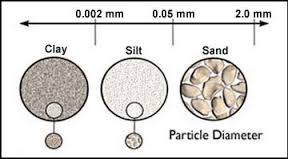
    2. Texture: The soil texture refers to the coarseness/fineness of the mineral matter in the soil. It is determined by the proportion of the sand, silt and clay particles:

    1. Clay: Particle Size – diameters less than 0.002 millimetre
    2. Silt: Particle Size – diameters between 0.002 millimetres to 0.05 millimetres.
    3. Sand: Particle Size – diameters between 0.05 and 2 millimetres.

    [Rocks larger than 2 millimetres are regarded as pebbles, gravel, or rock fragments and technically are not soil particles.]

    Note: Clay being the finest of all plays the most important role in soil chemistry (offers more surface area).

    The proportions of each of these soil fractions determine soil texture and its properties.

    The soil texture directly affects:

    • The soil water content
    • Water flow
    • Retention of nutrients
    • Extent of aeration

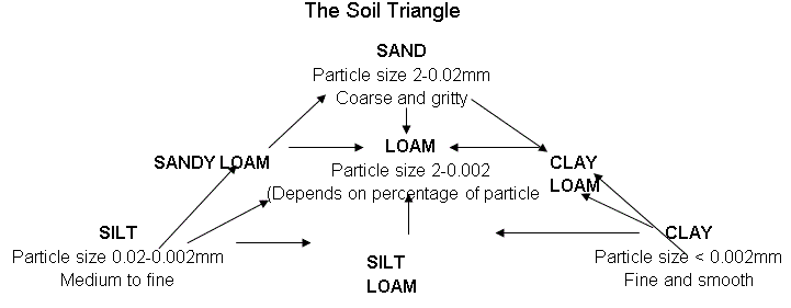
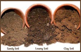
    Loamy Soil: Loamy soil is the one in which none of the three (sand/silt/clay) dominates the other two. In particular, loamy soil has about 40% sand, 40%silt, and 20% clay.

    Note: Generally speaking, Good Soils = Clay + Humus. The clay-humus complex is essential for a fertile soil as it provides it with a high water and nutrient holding capacity. Humus acts as a cement binding the soil particles together and thus reducing the risk of erosion.

    3. Structure :

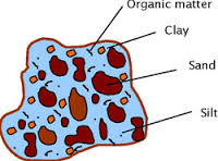
    While the soil texture describes the size of soil particles, soil structure refers to the arrangement of the soil particles. The way in which sand, silt, clay and humus bond together is called soil structure. Structure can partially modify the effects of soil texture.

    Some structural characteristics of soil:

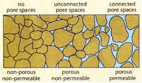
    • Permeability – The ease with which liquids/gases can pass through rocks or a layer of soil is called permeability. It depends on the size, shape and packing of particles. It is usually greatest in sandy soils and poor in clayey soils.
    • Porosity – The volume of water which can be held within a soil is called its porosity. It is expressed as a ratio of volume of voids (pores) to the total volume of the material.
    • Note: Most porous rocks are permeable with the exception of clay in which pore spaces are so small that they are often sealed with groundwater held by surface tension. Another exception – granite is non-porous but permeable. It is a crystalline rock and hence non-porous. Its individual crystals absorb little or no water but the rock may have numerous joints/ cracks through which the water can pass rendering it permeable.
    • A soil with high organic content also tends to have high porosity.

    4. Soil Chemistry – Acidity or Alkalinity:

    An important aspect of soil chemistry is acidity, alkalinity (baseness), or neutrality.

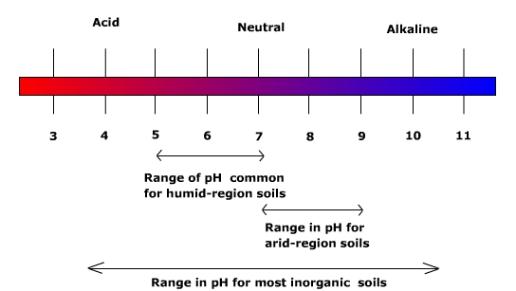
    Low pH values indicate an acidic soil, and a high pH indicates alkaline conditions. Most complex plants grow only in the soils with levels between pH 4 and pH 10 but optimum pH varies with the plant species.

    • In arid and semi-arid regions, soils tend to be alkaline and soils in humid regions tend to be acidic.
    • To correct soil alkalinity and to make the soil more productive, the soil can be flushed with irrigation water.
    • Strongly acidic soils are also detrimental to plant growth, but soil acidity can generally be corrected by adding lime to the soil.

    Now that we are done with the basics, let’s move on to the soils of India!

    Soils of India

    India has varied relief features, landforms, climatic realms and vegetation types. These have contributed to the development of various types of soils in India.

    Various classifications adopted to study the Indian Soils:

    1. In ancient times, soils used to be classified into two main groups:

    • Urvara (i.e. fertile), and
    • Usara (i.e. sterile)

    2. In the 16th century A.D., soils were classified on the basis of their inherent characteristics and external features such as texture, colour, the slope of land and moisture content in the soil.

    • Based on texture, main soil types were identified as sandy, clayey, silty and loam, etc.
    • On the basis of colour, they were red, yellow, black, etc.

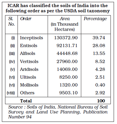
    3. The National Bureau of Soil Survey and the Land Use Planning an Institute under the control of the Indian Council of Agricultural Research (ICAR) did a lot of studies on Indian soils. In their effort to study soil and to make it comparable at the international level, the ICAR has classified the Indian soils on the basis of their nature and character as per the United States Department of Agriculture (USDA) Soil Taxonomy.

    Chief characteristics of these are:

    • Entisols – Immature soils that lack the vertical development of horizons. These soils are often associated with recently deposited sediments from wind, water, or ice erosion. Given more time, these soils will develop into another soil type.
    • Inceptisols – young soils that are more developed than entisols.
    • Vertisols – heavy clay soils that show significant expansion and contraction due to the presence or absence of moisture. These are common in areas that have shale parent material and heavy precipitation.
    • Aridisols – soils that develop in very dry environments.
    • Ultisols – associated with humid temperate to tropical climates. Warm temperatures and the abundant variability of moisture enhance the weathering process and increase the rate of leaching in these soils.
    • Mollisols – soils common to grassland environments

    4. On the basis of genesis, colour, composition and location, the soils of India have been classified into:

    (i) Alluvial soils

    (ii) Black soils

    (iii) Red and Yellow soils

    (iv) Laterite soils

    (v) Arid soils

    (vi) Saline soils

    (vii) Peaty soils

    (viii) Forest soils.

    5. Another way of classifying rocks is on the basis of dominant soil-forming factors:

    • Zonal Soil – These soils occur in broad geographical areas or zones.
      • They are influenced more by the climate and vegetation of the area rather than the rock-type.
      • They are mature, as a result of stable conditions over a long period of time.
      • For example – red soils, black soils, laterite soils, desert soils etc.
    • Azonal Soil – It is that soil which has been developed by the process of deposition by the agents of erosion.
      • It means that it has been made by the fine rocky particles transported from the far-off regions.
      • These are immature soils and lack well-developed soil profiles. This may be due to the non-availability of sufficient time for them to develop fully or due to the location on very steep slopes which prohibits profile development.
      • For Example – alluvial and loess soils.
    • Intrazonal Soil – These soils occur within other zonal soils.
      • It is a well-developed soil reflecting the influence of some local factor of relief, parent material, or age rather than of climate and vegetation.
      • For example, calcerous soil (soils which develop from limestone), peat soil.

    Soils and Crops of India

    1. Alluvial Soils

    • Formation: They are mainly derived from the debris brought down from the Himalayas or the silt left out by the retreating sea. Thus they are azonal soils.
    • Areas: Alluvial soils are widespread in the northern plains and the river valleys. Through a narrow corridor in Rajasthan, they extend into the plains of Gujarat. In the Peninsular region, they are found in deltas of the east coast and in the river valleys.
    • Soil texture: The alluvial soils vary in nature from sandy loam to clay. These soils are more loamy and clayey in the lower and middle Ganga plain and the Brahmaputra valley. The sand content decreases from the west to east.
    • Soil Colour: The colour of the alluvial soils varies from the light grey to ash grey depending on the depth of the deposition, the texture of the materials, and the time taken for attaining maturity.
    • Other Characteristic Features:
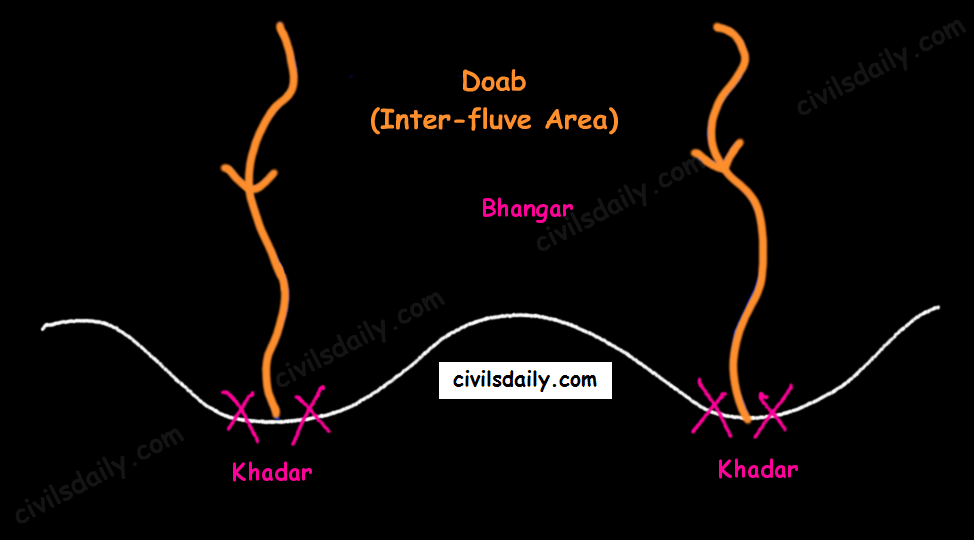
      • In the Upper and Middle Ganga plain, two different types of alluvial soils have developed, viz. Khadar and Bhangar.
    Khadar and Bhangar
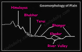
    • Khadar: the newer alluvium deposited by floods annually, enriches the soil by depositing fine silts, light colour, found near river beds, porous in nature. Bhangar: older alluvium, clayey, darker, has lime nodules called Kankars, found in doabs (inter-fluve areas).
    • Alluvial soils of the northern plains —> transported soils —>, therefore, lack humus —> lack nitrogen [That is why we need to use nitrogenous fertilisers in the northern plains!]. Exception: the Ganga-Brahmaputra delta region is rich in humus.
    • These soils lack in nitrogen, phosphorus and humus. However, they are generally rich in potash and lime.
    • The soil profile has no stratification.
    • Alluvial soils are intensively cultivated.
    • In certain areas, these soils are covered with unproductive wind-borne soil called Loess.
    • Limitations:
      • Allow water to sink into lower strata, and
      • Lack nitrogen (But these soils are capable of fixing nitrogen very rapidly through leguminous crops (peas, beans, cloves etc.)
    • Suitable Crops: Wheat, rice, maize, sugarcane, pulses, oilseeds, fruits and vegetables, leguminous crops.

    2. Black Soil

    • These soils are locally known as the ‘Regur Soil’ or the ‘Black Cotton Soil’. Internationally, these are known as ‘tropical chernozems’. These soils are famous for the cultivation of cotton.
    • Formation: These have mainly formed from the Deccan Trap rocks —> Zonal Soils
    • Areas: These are found in the Deccan trap region. Black soil covers most of the Deccan Plateau which include parts of:
      • Maharashtra,
      • Madhya Pradesh,
      • Gujarat,
      • Andhra Pradesh and some parts of
      • Tamil Nadu.
    • Soil Texture: Black cotton soil (regur soil) is highly argillaceous i.e. clayey. It is deep and impermeable and thus has high water retention capacity.
    • Soil Colour: These soils are black in colour due to the presence of iron, aluminium compounds and humus.
    • Other Characteristic Features:
      • These soils are rich in minerals and known for their fertility.
      • The soil depth varies from place to place. It is very thick in lowlands but very thin on highlands. Also, in the upper reaches of the Godavari and the Krishna, and the northwestern part of the Deccan Plateau, the black soil is very deep.
      • These soils swell and become sticky when wet and develop deep wide cracks when dry. This helps in self-aeration, which leads to the absorption of nitrogen from the atmosphere. Thus, there occurs a kind of ‘self ploughing’. This aeration and oxidisation to deep levels contribute to the maintenance of the fertility of these soils. This continued fertility is favourable in the area of low rainfall for cotton cultivation even without irrigation.
      • Due to slow absorption and loss of moisture, the black soil retains the moisture for a very long time, which helps the crops, especially, the rain-fed ones, to sustain even during the dry season.
      • Chemically, the black soils are rich in lime, iron, magnesia and alumina. They also contain potash. But they lack in phosphorous, nitrogen and organic matter.
    • Suitable Crops: These soils are highly productive and well suited to the cultivation of cotton, pulses, millets, linseed, tobacco, sugarcane, vegetables and citrus fruits.

    Note: In the southern and eastern parts of the country where rainfall is heavy, black soils often occur in close proximity to red soils. Black soils occupy valleys and low-level areas whereas the red soils occur on higher slopes and hilltops. Mixed black and red soils occur in Coimbatore, Madurai, Tirunelveli (Tamil Nadu) and Bundelkhand region.

    3. Red and Yellow Soils

    • Locally called ‘Chalka’ in Andhra Pradesh.
    • Formation: These are derived from granites, gneisses and other metamorphic rocks —> Zonal Soils. These are formed under well-drained conditions.
    • Areas: Along the piedmont zone of the Western Ghat, a long stretch of area is occupied by red loamy soil. Yellow and red soils are also found in parts of Orissa and Chattisgarh and in the southern parts of the middle Ganga plain. They encircle the black cotton soil zone.
    • Soil Colour: The soil develops a reddish colour due to a wide diffusion of iron in crystalline and metamorphic rocks. It looks yellow when it occurs in a hydrated form. Often, their upper layer is red and the lower layer is yellow.
    • Soil Texture: Varies from sand to clay and loam.
    • Other Characteristic Features:
      • The fine-grained red and yellow soils are normally fertile, whereas coarse-grained soils found in dry upland areas are poor in fertility.
      • Have a porous and friable structure.
      • They are generally poor in nitrogen, phosphorous and humus.
      • These soils are airy and need irrigation for cultivation.
      • Intense leaching is a menace in these soil areas.
    • Suitable Crops: In places where irrigation facilities are available, the crops cultivated are wheat, cotton, pulses, tobacco, millets, oilseeds, potato, maize, groundnut and orchards.

    4. Laterite Soil

    • The word laterite has been derived from the Latin word ‘Later’ which means brick. These soils when wet are as soft as butter but become hard and cloddy on drying. Therefore, these are widely cut as bricks for use in house construction.
    • Formation: The lateritic soils are particularly found on high flat erosion surfaces in areas of high(>200cm) and seasonal rainfall. The alternating wet and dry seasons lead to the leaching away of the siliceous matter of the rocks leaving behind the compounds of iron and aluminium. These are zonal soils.
    • Areas: These soils have mainly developed in the higher areas of the Peninsular plateau. The laterite soils are commonly found in Karnataka, Kerala, Tamil Nadu, Madhya Pradesh and the hilly areas of Orissa and Assam.
    • Soil Colour: Reddish-brown in colour due to the presence of iron oxide.
    • Other characteristic features:
      • With rain, lime and silica are leached away, and soils rich in iron oxide and aluminium compound are left behind(thus the reddish-brown colour). Also, the humus content of the soil is removed fast by bacteria that thrive well in high temperature.
      • These soils represent the end product of decomposition and are generally low in fertility.
      • The pebbly crust is the important feature of laterites which is formed due to alteration of wet and dry periods.
      • These soils are acidic in character due to leaching. Application of manures and fertilisers is required for making these soils fertile for cultivation.
      • These soils are poor in organic matter, nitrogen, phosphate and calcium, while iron oxide and potash are in excess.
    • Suitable crops: Red laterite soils in Tamil Nadu, Andhra Pradesh and Kerala are more suitable for tree crops like cashew nut. These soils are also suitable for tea plantations.

    We discussed in detail alluvial, black, red and laterite soils. Let’s continue the discussion and move on to the next soil types!

    5. Arid Soils

    • Formation: These are derived from the disintegration of adjacent rocks and are largely blown from coastal regions and Indus valley.
    • Areas: Arid soils are characteristically developed in western Rajasthan, which exhibits characteristic arid topography.
    • Soil Colour: Arid soils range from red to brown in colour.
    • Soil Texture: They are generally sandy to gravelly in texture and have a high percentage of soluble salts.
    • Other characteristic features:
      • These are saline in nature. In some areas, the salt content is so high that common salt is obtained by evaporating the saline water.
      • Due to the dry climate, high temperature and accelerated evaporation, they lack moisture and humus.
      • These soils are deficient in nitrogen and humus. The phosphate and iron content is normal. These soils are rich in minerals but the main limitation is the lack of water.
      • The soils exhibit poorly developed horizons.
      • Plants are widely spaced.
      • Chemical weathering is limited.
      • Lower horizons of the soil are occupied by ‘kankar’ layers because of the increasing calcium content downwards. The ‘Kankar’ layer formation in the bottom horizons restricts the infiltration of water, and as such when irrigation is made available, the soil moisture is readily available for sustainable plant growth.
    • Suitable crops: If irrigated these soils give high agricultural returns. The availability of water from the Indira Gandhi canal has transformed the agricultural landscape of desert soils of western Rajasthan. These soils are mainly devoted to bajra, pulses, guar, fodder and less water requiring crops.

    6. Saline and Alkaline Soils

    • They are also known as Usara soils. Various local names for saline soils are Reh, Kallar, and Chopan, Rakar, Thur, Karl etc.
    • Formation:
      • These soils have developed in areas with dry climatic conditions (in areas having a little more rainfall than the areas of desert soils) accompanied by lack of proper drainage. In this situation, salts of sodium, calcium and magnesium are deposited on the upper layer of the soil by capillary action.
      • In the Rann of Kuchchh, the Southwest Monsoon brings salt particles and deposits there as a crust.
      • These soils are also formed when saline water spreads on the land at the time of high tide in coastal areas. Also, seawater intrusions in the deltas promote the occurrence of saline soils.
      • Salinization also occurs because of over-irrigation (canal irrigation/groundwater use) and in areas of the high water table (as in the coastal areas of Maharashtra and Tamil Nadu). Salinity from irrigation can occur over time wherever irrigation occurs. This is because almost all water (even natural rainfall) contains some dissolved salts. When the plants use the water, the salts are left behind in the soil and eventually begin to accumulate. Also, excessive irrigation with dry climatic conditions promotes capillary action, which results in the deposition of salt on the top layer of the soil (See the following figure).
      • These are thus, intrazonal soils.
    • Areas: They occur in arid and semi-arid regions, and in waterlogged and swampy areas. These are more widespread in western Gujarat, deltas of the eastern coast and in Sunderban areas of West Bengal.
    • Soil Texture: Their texture ranges from sandy to loamy.
    • Other characteristic features:
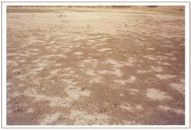
      • Because of capillary action, the salts are sucked up in solution to the surface and form white encrustations on the surface (See the picture below).
      • The salt efflorescence of calcium, magnesium and sodium makes these soils infertile.
      • Saline soils contain an excess of neutral soluble salts of chlorides and sulphates whereas sodic or alkali soils contain sodium carbonates/ sodium bicarbonates.
      • They lack in nitrogen and calcium and have low water-bearing capacity.
      • These soils can be reclaimed by improving drainage, by applying gypsum and/or lime, and by cultivating salt-resistant crops like barseem, dhaincha and other leguminous crops.
      • The saline and alkaline soils may occur in any group of soils.
    • Crops grown: In coastal areas, coconut trees are found in plenty in these soils. As discussed above, cultivating salt-resistant crops like bar seem, dhaincha and other leguminous crops can help in reclaiming these soils.
    • Note: In the areas of intensive cultivation with excessive use of irrigation, especially in areas of green revolution, the fertile alluvial soils are becoming saline. In such areas, especially in Punjab and Haryana, farmers are advised to add gypsum to solve the problem of salinity in the soil.

    7. Peaty Soils

    • These soils are locally called Kari in Kottayam and Alleppey districts of Kerala.
    • Formation: These are marshy soils and are a result of waterlogging and anaerobic conditions (which leads to partial decomposition of organic matter).
    • Areas: They are found in the areas of heavy rainfall and high humidity, where there is a good growth of vegetation. It occurs widely in the northern part of Bihar, the southern part of Uttaranchal and the coastal areas of West Bengal, Orissa and Tamil Nadu.
    • Soil Colour and Texture: These soils are normally heavy and black in colour
    • Other characteristic features:
      • These soils are characterised by a rich humus and organic content.
      • There is a presence of iron and varying amounts of organic matter (10-40%). The organic matter in these soils may go even up to 40-50 per cent.
      • These soils are generally acidic in nature. But at many places, they are alkaline also.
    • Suitable crops: These are generally submerged during the rainy season and utilised for the cultivation of rice.

    8. Forest Soils

    • Formation: As the name suggests, forest soils are formed in the forest areas where sufficient rainfall is available.
    • Areas: These are found in the forest areas of Himalayas, Sahyadris, Eastern Ghats and terai region.
    • Soil colour and texture: The soils vary in structure and texture depending on the mountain environment where they are formed. They are loamy and silty on valley sides and coarse-grained in the upper slopes. Their colour is dark brown.
    • Other Characteristics:
      • In the snow-bound areas of the Himalayas, they are acidic with low humus content. This is because humus is rawer at higher levels. Also, these soils are subjected to denudation due to landslides and snowfall.
      • The soils found in the lower valleys are fertile and rich in organic content.
      • Owing to sharp differences of hill slopes and climates, these soils may differ greatly even when in proximity. [Recall here the discussion on the impact of topography on soils!]
      • Also, these soils exist in thin layers because of their development on the mountain slopes.
      • These soils are poor in potash, phosphorus and lime.
      • Soil erosion is a major problem in these areas.
    • Crops grown: The slopes are used for horticulture and plantations crops like tea, coffee, spices, apple, peach etc. Rice and wheat are grown in valleys. Potatoes are grown in mostly all areas.

    Now that we are done with all the soil types, expand the following image for a quick revision!

    Methods of Irrigation

    Irrigation

    • Irrigation is the artificial application of water to the soil or agricultural field. It is the replacement or supplementation of rainwater with another source of water. It is used in dry areas and during periods of inadequate rainfall.
    • The main idea behind irrigation systems is to assist in the growth of agricultural crops and plants by maintaining with the minimum amount of water required, suppressing weed growth in grain fields, preventing soil consolidation etc.

    Well and Tube Well Irrigation

    • Wells are mainly found in U.P., Bihar, Tamil Nadu, etc. There are various types of wells – shallow wells, deep wells, tube wells, artesian wells, etc. From the shallow wells water is not always available as the level of water goes down during the dry months. Deep wells are more suitable for the purpose of irrigation as water from them is available throughout the year.
    • At places where ground water is available, a tube-well can be installed near the agricultural area. A deep tube well worked by electricity, can irrigate a much larger area (about 400 hectares) than a surface well (half hectares). Tube wells are mostly used in U.P., Haryana, Punjab, Bihar and Gujarat.
    • Merits: Well is simplest, cheapest and independent source of irrigation and can be used as and when the necessity arises. Several chemicals such as nitrate, chloride, sulphate, etc. found in well water add to the fertility of soil. More reliable during periods of drought when surface water dries up.
    • Demerits: Only limited area can be irrigated. In the event of a drought, the ground water level falls and enough water is not available. Tubewells can draw a lot of groundwater from its neighbouring areas and make the ground dry and unfit for agriculture.

    Canal Irrigation

    • Canals can be an effective source of irrigation in areas of low level relief, deep fertile soils, perennial source of water and extensive command area. Therefore, the main concentration of canal irrigation is in the northern plain of India, especially the areas comprising Uttar Pradesh, Haryana and Punjab.
    • The digging of canals in rocky and uneven areas is difficult and uneconomic. Thus, canals are practically absent from the Peninsular plateau area. However, the coastal and the delta regions in South India do have some canals for irrigation.
    • Two types: Inundation canals, which are taken out from the rivers without any regulating system like weirs etc. at their head. Such canals provide irrigation mainly in the rainy season when the river is in flood and there is excess water. Perennial Canals are those which are taken off from perennial rivers by constructing a barrage across the river. Most of the canals in India are perennial.
    • Merits: Most of the canals provide perennial irrigation and supply water as and when needed. This saves the crops from drought conditions and helps in increasing the farm production.
    • Demerits: Many canals overflow during the rainy season and flood the surrounding areas. Canal irrigation is suitable in plain areas only.

    Tank Irrigation

    • A tank is developed by constructing a small bund of earth or stones built across a stream. The water impounded by the bund is used for irrigation and other purposes. Tank comprises an important source of irrigation in the Karnataka Plateau, MP, Maharashtra, Odisha, Kerala Bundelkhand area of UP, Rajasthan and Gujarat.
    • Merits: Most of the tanks are natural and do not involve heavy cost for their construction and have longer life span. In many tanks, fishing is also carried on, which supplements both the food resources and income of the farmer.
    • Demerits: Many tanks dry up during the dry season and fail to provide irrigation when it is required. Lifting of water from tanks and carrying it to the fields is a strenuous and costly exercise.

    Drip Irrigation

    • In drip irrigation, water is applied near the plant root through emitters or drippers, on or below the soil surface, at a low rate varying from 2-20 liters per hour. The soil moisture is kept at an optimum level with frequent irrigations.
    • Among all irrigation methods, drip irrigation is the most efficient and can be practiced for a large variety of crops, especially in vegetables, orchard crops, flowers and plantation crops.
    • Merits: Fertilizer and nutrient loss is minimized due to localized application and reduced leaching. Field leveling is not necessary. Recycled non-potable water can be used. Water application efficiency increases. Soil erosion and weed growth is lessened.
    • Demerits: Initial cost can be more, can result in clogging, wastage of water, time and harvest, if not installed properly.

    Sprinkler Irrigation

    • In this method, water is sprayed into the air and allowed to fall on the ground surface somewhat resembling rainfall. The spray is developed by the flow of water under pressure through small orifices or nozzles. The sprinkler irrigation system is a very suitable method for irrigation on uneven lands and on shallow soils.
    • Nearly all crops are suitable for sprinkler irrigation systems except crops like paddy, jute, etc. The dry crops, vegetables, flowering crops, orchards, plantation crops like tea, coffee are all suitable and can be irrigated through sprinklers.
    • Merits: Suitable to all types of soil except heavy clay. Water saving. Increase in yield. Saves land as no bunds etc. are required.
    • Demerits: Higher initial cost. Under high wind conditions and high temperature distribution and application efficiency is poor.

    Other Types of Irrigation

    • Furrow Irrigation: Furrow irrigation is a type of surface irrigation in which trenches or “furrows” are dug between crop rows in a field. Farmers flow water down the furrows and it seeps vertically and horizontally to refill the soil reservoir. Flow to each furrow is individually controlled.

      • One of the difficulties of furrow irrigation is ensuring uniform dispersion of water over a given field. Another difficulty with furrow irrigation is the increased potential for water loss due to runoff.
    • Surge Irrigation: Surge irrigation is a variant of furrow irrigation where the water supply is pulsed on and off in planned time periods. The wetting and drying cycles reduce infiltration rates resulting in faster advance rates and higher uniformities than continuous flow.
    • Ditch Irrigation: It is a rather traditional method, where ditches are dug out and seedlings are planted in rows. The plantings are watered by placing canals or furrows in between the rows of plants. Siphon tubes are used to move the water from the main ditch to the canals.
    • Sub Irrigation or Seepage Irrigation: It is a method of irrigation where water is delivered to the plant root zone from below the soil surface and absorbed upwards. The excess may be collected for reuse.
      • Advantages are water and nutrient conservation, and labor-saving.
      • The outfitting cost is relatively high. Potential problems, such as the possibility of increased presence of disease in recycle water.

    UPSC 2022 countdown has begun! Get your personal guidance plan now! (Click here)
    Samanvaya: Free 1-to-1 mentorship for UPSC IAS

    Fill up this form to schedule a free on-call discussion with senior mentor from Civilsdaily. Once submitted we will call you within 24 hours.

    Civilsdaily Samanvaya 1-On-1 Mentorship Form

    Field will not be visible to web visitor

  • [RSTV Archive] Circular Economy: Concept & Challenges

    UPSC 2022 countdown has begun! Get your personal guidance plan now! (Click here)
    With a growing population, rapid urbanization, climate change and environmental pollution, India must move towards a circular economy. An economic approach aimed at eliminating waste and the continual use of resources, the circular economy offers a new paradigm that emphasizes the need to take a comprehensive view of products and processes.

    In this article, we shall understand the concept of a Circular economy over a linear one and also look at challenges that lie ahead.

    Circular Economy: The Concept

    • A circular economy (also referred to as “circularity”)is an economic system that tackles global challenges like climate change, biodiversity loss, waste, and pollution.
    • Most linear economy businesses take a natural resource and turn it into a product which is ultimately destined to become waste because of the way it has been designed and made.
    • This process is often summarized by “take, make, waste”.
    • By contrast, a circular economy includes 3 R’s (Reduce, Reuse and Recycle), Refurbishment, Recover, and Repairing of materials.
    • Hence, Circular Economy focuses on increasing productivity in terms of more efficient utilization of resources.

    Principles of Circular Economy

    The concept is based on three main principles:

    #1 Minimization of waste and pollution

    The concept suggests the minimization of waste and pollution by reducing damages from economic activities.

    #2 Extension of the useful life of products and materials

    A circular economy aims to extend the useful life of the products and materials by creating the loops of the materials and products circulating in the economy. The goal is achieved through the active reuse, repair, and remanufacturing of the products and materials utilized in the economy.

    #3 Regeneration of natural systems

    The regeneration of natural systems is one of the fundamental concepts of a (circular) economy. It enhances natural capital and creates the necessary conditions for the regeneration of natural systems.

    Why is the global attention towards this?

    • Raw material supply: Circular Economy fulfills the need for raw materials required by industries, especially the manufacturing industries.
    • Input costs are minimized: The output produced by industries in a circular economy comes back to the industries in the form of input.
    • QCDF improvement: Ultimately, QCDF (Quality, Cost, Delivery, and Flexibility) and sustainability level of industries get improved.

    Applications of Circularity

    (A) Construction sector

    (B) Food and Agriculture

    (C) Transportation and Mobility

    Benefits offered by Circular Economy

    For Economy

    • Economic growth, as defined by GDP, would be achieved mainly through a combination of increased revenues from emerging circular activities.
    • It lowers the cost of production through the more productive utilization of inputs.  
    • These changes in input and output of economic production activities affect economy-wide supply, demand, and prices.
    • Its effects ripple through all sectors of the economy adding to overall economic growth.

    For Environment

    • It solves the problem of disposal of waste by converting waste into raw materials.
    • Besides the problem of solid waste management, the circular economy also solves the problem of air pollution, water pollution, and land pollution.

    For Individuals

    • Lower cost for products and services
    • Greater utility and choice
    • Reduced negative externalities, e.g. congestion, pollution
    • Increased Efficiency of the products

    Limitations to the circular economy models

    There is some criticism of the idea of the circular economy.

    • Linearity: Recovery and recycling of materials that have been dispersed through pollution, waste and end-of-life product disposal require energy and resources, which increase in a nonlinear manner as the percentage of recycled material rises
    • Waste management: Impossibility for waste producers to dissociate themselves from their waste and emphasizes the contingent, multiple, and transient value of waste.
    • Unavoidability: A key tenet of this principle is to consider waste as avoidable and worthy of interest.
    • Utopian concept:  Circular Economy analogy of a circle evokes endless perfection; the analogy of scats evokes disorienting messiness.
    • Capability: Proponents of the circular economy have tended to look at the world purely as an engineering system and have overlooked the economic part of the circular economy.
    • Invisible economy: Invisible hand of market forces will conspire to create full displacement of virgin material of the same kind.

    Need of the hour

    • India has a huge potential for reuse and recycling as less than 10-15% of the total waste generated goes into the recycling process.
    • Circular Economy will boost the reuse and recycling of materials.
    • To start with, sectors like construction, agriculture and vehicle and mobility can be considered as they are going to get the largest growth in coming years and thus India will be able to save more than Rs. 40 lakh Crore by 2030.

    India’s roadmap

    • Digital India’: This mission contains a significant component of the recycling of electronic wastes. Swachh Bharat Mission is also about making wealth out of wastes.
    • Vehicle Scrappage Policy: This most recent reflects the perfect application of circular economy in Automobile sector.

    Way forward

    • Build circular economy knowledge and capacity: Taking maximum advantage of circular models requires decision-makers throughout the organisation to understand the benefits and take them into account in business decisions.
    • Innovate to create new products and business models and demonstrate their success: Businesses can foster innovation to address challenges, such as transition costs, more rapidly by collaborating with research institutions and by making information open source.
    • Collaborate with other businesses, policymakers, and the informal economy: Participation in pre-competitive collaboration in cross-industry and cross-value-chain networks can enable businesses to drive change that they cannot create on their own.
    • Invest in circular economy opportunities: While sizing and prioritizing the value of investment related to the circular economy opportunities outlined in this report requires detailed analysis, the circular economy offers attractive opportunities for both businesses and financial institutions.

    Conclusion

    • Resources in the world are finite. The circular economy will help the inefficient utilization of resources.
    • Political will is the key for implementation of Circular Economy.
    • Countries including India need to think about what they are taking from the environment and what they are contributing to it.
    • They also need to ensure that the material gets recycled or reused before it turns into waste.

  • Important Straits

    UPSC 2022 countdown has begun! Get your personal guidance plan now! (Click here)
    02 Sept 2021

    A strait is a naturally formed, narrow, typically navigable waterway that connects two larger bodies of water. Most commonly it is a channel of water that lies between two landmasses. Some straits are not navigable, for example, because they are too shallow, or because of an unnavigable reef or archipelago.

    1. Strait of Hormuz
    • It links the Persian Gulf (west) with the Gulf of Oman and the Arabian Sea (southeast).
    • On the north coast lies Iran, and on the south coast the United Arab Emirates and Musandam, an exclave of Oman. 
    • The strait is 35 to 60 miles (55 to 95 km) wide and separates Iran from the Arabian Peninsula.
    • It contains the islands of Qeshm (Qishm), Hormuz, and Hengām (Henjām) and is of great strategic and economic importance, especially as oil tankers collecting from various ports on the Persian Gulf must pass through the strait.
    • OPEC members Saudi Arabia, Iran, the UAE, Kuwait and Iraq export most of their crude via the Strait
    • Qatar, the world’s biggest liquefied natural gas (LNG) exporter, sends almost all of its LNG through the Strait
    • The UAE and Saudi Arabia have sought to find other routes to bypass the Strait, including building pipelines.

    2. Strait of Malacca

    • Strait of Malacca connects the Andaman Sea (Indian Ocean) and the South China Sea (Pacific Ocean).
    • Stretching about 800km, it is the longest straits in the world and facilitates not just shipping and the movement of people in the surrounding communities but is a confluence of trade, cultures, ideas, and knowledge between the East and West.
    • It runs between the Indonesian island of Sumatra to the west and peninsular (West) Malaysia and extreme southern Thailand to the east and has an area of about 25,000 square miles (65,000 square km).
    • The strait derived its name from the trading port of Melaka (formerly Malacca)—which was of importance in the 16th and 17th centuries—on the Malay coast.
    • As the link between the Indian Ocean and the South China Sea, the Strait of Malacca is the shortest sea route between India and China and hence is one of the most heavily travelled shipping channels in the world.
    • Singapore, one of the world’s most important ports, is situated at the strait’s southern end.
    • The global shift in economic power from the West to the East coupled with burgeoning trade, investments, and production in areas spanning the Indian and Pacific Ocean regions has given increasing importance to this region.

    3. Bab-el-Mandab

    • The Bab al-Mandab strait is the narrow waterway that separates the Arabian Peninsula from the Horn of Africa.
    • It links the Red Sea to the Gulf of Aden and the Indian Ocean.
    • At its narrowest point, the strait is only 29 km wide between Yemen on one side and Djibouti and Eritrea on the other.
    • It is a key strategic channel for commerce and trade, with an estimated 4 percent of global oil supply passing through it.

    4. Palk Strait

    • It connects the Bay of Bengal in the northeast with Palk Bay in the southwest.
    • The strait is 40 to 85 miles (64 to 137 km) wide, 85 miles long, and less than 330 feet (100 metres) deep.
    • It receives several rivers, including the Vaigai (India), and it contains many islands on the Sri Lankan side.
    • The Sethusamudram Ship Canal Project (SSCP) is a 167 km long shipping canal, and envisages the creation of a navigable canal from the Gulf of. Mannar to the Bay of Bengal to facilitate the movement of ships.
    • The Adam’s Bridge is a series of sand shoals created by sedimentation over a period of time.
    • All islands are made up of a calcareous framework of dead reef and sand.
    • In India, the Gulf of Mannar region in Tamil Nadu is one of the four major coral reef areas and the others are Gulf of Kutch in Gujarat, Lakhsadweep and Andaman and Nicobar islands.
    • With its rich biodiversity of over 4,000 species of various flora and fauna, part of this Gulf of Mannar between Rameswaram and Tuticoirin covering 21 islands and the surrounding shallow coastal waters was declared as a Marine National Park in 1986.

    5.Sunda Strait

    • It links the Java Sea (Pacific Ocean) with the Indian Ocean (south).
    • Sunda Strait, Indonesian Selat Sunda, is a channel, 16–70 miles (26–110 km) wide, between the islands of Java (east) and Sumatra.
    • The Sunda Strait is an important passage connecting the Indian Ocean with eastern Asia.
    • The strait stretches in a roughly northeast/southwest orientation, with a minimum width of 24 km (15 mi) at its northeastern end between Cape Tua on Sumatra and Cape Pujat on Java.
    • It is very deep at its western end, but as it narrows to the east it becomes much shallower, with a depth of only 20 m (65 feet) in parts of the eastern end.
    • It is notoriously difficult to navigate because of this shallowness, very strong tidal currents, sandbanks, and man-made obstructions such as oil platforms off the Java coast.
    • The strait’s narrowness, shallowness, and lack of accurate charting make it unsuitable for many modern, large ships, most of which use the Strait of Malacca instead.

    6.Mozambique Channel

    • It is located between the island nation of Madagascar on the east and Mozambique on the African mainland (west).
    • About 1,000 miles (1,600 km) long, it varies in width from 250 to 600 miles (400 to 950 km) and reaches a maximum depth of 10,000 feet (3,000 m).
    • The Comoro Archipelago marks the northern entrance, and the islands of Bassas da India and Europa lie in the south.
    • An important route for shipping in eastern Africa, it receives all major Madagascar rivers and has the ports of Mahajanga (Majunga) and Toliary (Tuléar) on the same coast.
    • Along the opposite coast are the mouth of the Zambezi River and the ports of Maputo (formerly Lourenço Marques), Moçambique, and Beira.
    • The Mozambique Current passes through the strait.

    7.Gibraltar Strait

    • It is a channel connecting the Mediterranean Sea with the Atlantic Ocean, lying between southernmost Spain and northwesternmost Africa.
    • It is 36 miles (58 km) long and narrows to 8 miles (13 km) in width between Point Marroquí (Spain) and Point Cires (Morocco).
    • It is one of the most significant global sea lanes because it provides a means of seaborne transit for shipping between the Atlantic and Mediterranean, and via the Suez Canal into the Indian Ocean and beyond.
    • After the English Channel, the Strait is the world’s busiest shipping lane.

    8. Bosphorus strait and Dardanelles strait

    • Bosphorus,also known as the Strait of Istanbul, is a narrow, natural strait and an internationally significant waterway located in northwestern Turkey.
    • The Bosporus connects the Black Sea with the Sea of Marmara, and, by extension via the Dardanelles, the Aegean and Mediterranean seas.
    • It is the world’s narrowest strait used for international navigation.
    • Dardanelles is a narrow, natural strait and internationally significant waterway in northwestern Turkey that forms part of the continental boundary between Europe and Asia, and separates Asian Turkey from European Turkey.
    • The Dardanelles connects the Sea of Marmara with the Aegean and Mediterranean Seas, while also allowing passage to the Black Sea by extension via the Bosphorus.
    • The Dardanelles is 61 kilometres (38 mi) long, and 1.2 to 6 kilometres (0.75 to 3.73 mi) wide, averaging 55 metres (180 ft) deep with a maximum depth of 103 metres (338 ft) at its narrowest point abreast the city of Çanakkale

    9. Yucatan Strait

    Joining seas/ Water Bodies : Gulf of Mexico and Caribbean Sea

    Location: Mexico-Cuba

    10. Mesina Strait  

    Joining seas/ Water Bodies : Mediterranean Sea

    Location: Italy-Sicily

    11. Otranto Strait

    Joining seas/ Water Bodies :Adriatic Sea & Ionian Sea

    Location: Italy-Albania

    12. Cook Strait 

    Joining seas/ Water Bodies :South Pacific Ocean

    Location:  New Zealand (North & South Islands)

    13. North Channel

    Joining seas/ Water Bodies :Irish Sea & Atlantic Ocean

    Location: Ireland-England

    14. Hudson strait     

    Joining seas/ Water Bodies : Gulf of Hudson & Atlantic Ocean

    Location: Canada

    15. Magellan strait   

    Join: Pacific and South Atlantic Ocean

    Location: Chile

    16. Makassar Strait

    Joining seas/ Water Bodies: the Java Sea & Celebes Sea

    Location: Indonesia

    17. Tsugaru Strait 

    Joining seas/ Water Bodies: Japan Sea and Pacific Ocean

    Location: Japan (Hokkaido-Honshu Island)

    18. Tatar Strait  

    Joining seas/ Water Bodies: Japan Sea & Okhotsk Sea

    Location: Russia (East Russia-Sakhalin Islands)

    19. Fovex Strait 

    Joining seas/ Water Bodies: South Pacific Ocean

    Location: New Zealand (South Island- Stewart Island)

    20. Formosa Strait  

    Joining seas/ Water Bodies: the South China Sea & East China Sea

    Location: China-Taiwan

    21. Taurus Strait

    Joining seas/ Water Bodies:Arafura Sea & Gulf of Papua

    Location: Papua New Guinea — Australia

    22. Bass Strait

    Joining seas/ Water Bodies: the Tasman Sea & South Sea

    Location: Australia

    23. Bering Strait

    Joining seas/ Water Bodies: the Bering Sea & Chukchi Sea

    Location: Alaska-Russia

    24. Bonne-Fasio Strait

    Joining seas/ Water Bodies: Mediterranean Sea

    Location: Corsica — Sardinia

    25. Davis Strait  

    Joining seas/ Water Bodies : the Baffin Bay & Atlantic Ocean

    Location: Greenland-Canada

    26. Denmark Strait 

    Joining seas/ Water Bodies: North Atlantic and the Arctic Ocean

    Location: Greenland-Iceland

    27. Dover strait  

    Joining seas/ Water Bodies: The English Channel & North Sea

    Location: England-France

    28. Florida Strait

    Joining seas/ Water Bodies: Gulf of Mexico and the Atlantic Ocean

    Location: USA-Cuba


    UPSC 2022 countdown has begun! Get your personal guidance plan now! (Click here)
    Samanvaya: Free 1-to-1 mentorship for UPSC IAS

    Fill up this form to schedule a free on-call discussion with senior mentor from Civilsdaily. Once submitted we will call you within 24 hours.

    Civilsdaily Samanvaya 1-On-1 Mentorship Form

    Field will not be visible to web visitor

  • [Yojana Archives] Indian Bureaucracy: A Historical Perspective

    UPSC 2022 countdown has begun! Get your personal guidance plan now! (Click here)
    August 2021: Public Administration

    Context

    • Bureaucracy is the backbone of the administrative machinery of the country which forms the permanent executive branch of the government.
    • From a reading of the historical literature, public administration in India can be traced back to the manuscripts of Arthashasthra written by Kautilya.
    • In the next major phase, Bharat witnessed the rule of the Guptas also termed by many historians as the ‘Golden Age.’
    • The discussion on ‘Historical Perspectives on Indian Bureaucracy’ begins with an overview of the history of civil services in India.

    What are Civil Services?

    • The Civil Services refer to the career civil servants who are the permanent executive branch of the Republic of India.
    • Elected cabinet ministers determine policy, and civil servants carry it out.

    If humans as a species are made to survive independently, then why administer them?  What would be the need for public administration? Does the public need to be administered or the administers are needed for the sustenance of public and society, at large? Is it merely about managing resources or it involves greater functioning of the systems?

    Why do we need Civil Services?

    • In the Indian context, in society as vast and heterogeneous, equitable distribution of resources and services is the key to the prosperity of all.
    • Gandhiji’s Talisman, ‘Whenever you are in doubt, or when the self becomes too much with you, apply the following test. Recall the face of the poorest and the weakest man [woman] whom you may have seen, and ask yourself, if the step you contemplate is going to be of any use to him [her]’ gives the necessary direction to this discussion.
    • Public administration is a system to ensure that these steps are contemplated and implemented for the growth, well-being, and prosperity of all including that poorest face.

    History of the Civil Services in India

    • The original conception of the ‘civil service’ can be traced back to the Royal Charters which gave the East India Company, the powers to raise a cadre of troops – for both civilian and military purposes.
    • The introduction of competitive exams in the mid-1800s was an important development which gave primacy to merit-based appointment as opposed to the privilege-based appointment through a referral system.
    • The commissions that were set up in reforming the public services – from the Macaulay Committee to the Islington Committee to the Lee Commission, strongly suggested that the Statutory Public Service Commission be brought into force.
    • During the Constituent Assembly Debates (CAD), there were detailed discussions and arguments about the continuity, the role and loyalty of Indian civil servants.
    • Sardar Vallabhbhai Patel was single-handedly responsible for setting up the Civil Services in Independent India and is, therefore, rightly called the ‘Iron Man of India’.

    Note: We shall not dive deeper into the evolution of Civil Services in India. That is better learnt in your Modern History Sources

    Early Indians in the Civil Service

    • The first Indian to clear the ICS exam was Satyendra Nath Tagore in the year 1864.
    • It is important to remember that until 1922 post the Montagu Chelmsford Reforms, the exam was conducted only in London, which greatly restricted the access of Indians to clear the examination.
    • However, there was a fair share of Indians who started clearing the exams.
    • The notable names being Bihari Lal Gupta and Romesh Chandra Dutt, who later became the President of the Indian National Congress in 1899 and wrote the pioneering book on ‘The Economic History of India ‘.
    • Netaji Subhas Chandra Bose did not join the Indian civil service even after clearing the exam that sheds light on the strong ideological stance Bose took during the freedom struggle.
    • Sir Benegal Narasinga Rau was another eminent personality among the ICS who was appointed as the Constitutional Advisor on 1st July 1946 over a year before India became independent. Later, he became the first judge of the International Court of Justice from India.
    • Sukumar Sen, India’s first Chief Election Commissioner, who later went on to become Sudan’s first Chief Election Commissioner as well, was one such hero.

    Constitution and the Civil Services

    • Articles 310, 311, and 312 of the Indian Constitution pertain to Services under the Union and State.
    • Article 310 enshrines that civil servant of the Union and All-India Services are appointed by the President of India and civil servants at the State level are appointed by the Governor of the State.
    • They continue to hold office as per the pleasure of the President and Governor, respectively. Therefore, they have the security of tenure.
    • Article 311 mentions the procedures and conditions for removal, dismissal from service, and reduction in rank, thus ensuring due process of law. This ensures that civil servants are protected from political interference and undue harassment.
    • Article 312 lays down the All-India Services of India. The Union Public Service Commission (UPSC) and the State Public Service Commissions are constitutional bodies.

    Related Information

    • Every year April 21 is ‘Civil Services Day’ to call on civil servants to renew their dedication and commitment to public service and excellence in work.’
    • On this day, the Prime Minister’s Excellence Awards are given to recognize and acknowledge outstanding work done by Districts/ Organizations of the Central and State Governments for outcome-oriented performance.

    Challenges and Reforms in the Civil Service

    • Post-independence, India adopted the socialist-welfare model of development which increased the scope of government’s interference in all key sectors of the economy.
    • Some of the fundamental tenets of a good bureaucracy are political neutrality, objectivity in decision-making, empathy, equity, etc. As an officer appointed to serve the public, one cannot take any political affiliation or alignment but do one’s work objectively and impartially.
    • Therein, constitutionalism matters because every civil servant must be guided by the letter and spirit of our Constitution.
    • Ethics in public administration are important because civil servants are often holding offices that give them a lot of power and authority. Therefore, an officer’s moral compass is key for good governance.

    Reforms in the CS

    • Various committees over the years have suggested changes and improvements to the civil services regarding recruitment, mid-career training, capacity-building, the impetus for specialisation, efficiency, accountability, etc.
    • The Second Administrative Reforms Commission (headed by Veerappa Moily) discussed the shortcomings and suggests improvements regarding recruitment, performance, and result-oriented bureaucracy.
    • In the last decade, several reforms have been undertaken.
    • Be it the introduction of lateral entry to have expert consultants at the Joint Secretary level, the regular training programmes of training at various levels for career civil servants and a record of performance evaluation.

    Debate over lateral entry

    • A more recent debate about the bureaucracy, especially the administrative service, is about ‘generalists’ versus ‘specialists’.
    • The role of an administrator is to ensure fair, equitable, and efficient administration of her/his unit, right from the sub-division, district and up to various departments and Ministries at the State and Central levels.
    • Therefore, a broad understanding of the various issues, departments, roles and responsibilities is sine qua non for quick and Effective redressal of public grievances.
    • So an officer who can effectively handle all areas of administration and policy from health to agriculture to defence, and ensure that work is done at levels junior to oneself needs to be one with ‘general skills’, although some say that the ability to administer well is in itself is a unique skill.

    However, specialization may be considered higher up in the ladder based on the officer’s qualifications, interests and work experience depending upon the needs and exigencies at that time.

    As technology develops and the socioeconomic changes transform India, we need to ensure that these changes do not outpace policy reform.

    Conclusion

    • Many fresh graduates from HTs, IIMs, NLUs and other professionals like doctors, chartered accountants, etc. appear for the UPSC Civil Services every year.
    • This has brought fresh energy and ideas into the bureaucracy. They bring with them their professional expertise adding richly to public administration.
    • Therefore, more and more young professionals from varied socio-economic and academic backgrounds need to enter the civil services to enrich it further and take part in nation-building.
  • 01st Sept 2021 | History Test 02

    [WpProQuiz 762]


    [WpProQuiz_toplist 759]

  • Major Rivers of India and the World and Mountain Ranges and Lakes


    UPSC 2022 countdown has begun! Get your personal guidance plan now! (Click here)
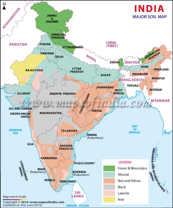
    01 Sept 2021

    Major Rivers in India

    Indus River System

    Indus Ancient name  Sindhu Origin  Bokharchu Glacier, Near Mansarovar In Tibet, Called Singi Khamban / Lion’s mouth Enters In India through Ladakh, flows only in J &K Enters Pak through hairpin bend of Nanga Parbat Finally Discharges in Arabian Sea Flows approx. ( 709 / 2880 ) Km in India India uses 20 % of its water by Indo  Pak water treaty of 1960
    ShyokOriginates from Rimo Glacier Known as river of death flows through Ladakh in India A tributary of the Indus River
    JhelumAncient name  Vitasta Origin  Verinag Spring (Kashmir) Tributary of Indus flows only in J &K Flows Northward to Wular Lake Cut through the gorge in Pir- Panjal range to reach Muzzafarabad (POK)
    Indus River System
    ChenabAncient name  Akshani / Iskmati Origin  Bara Lacha Pass (Himachal) Known as chandra-bhaga in Himachal Chandra River  Water flowing south from the pass Bhaga River      Water Flowing north from the pass Flows Northward & parallel to Pir –Panjal Range for some distance Cut through gorge in Pir – Panjal & Turns southward Largest tributary of Indus, Flows through Himachal & J & K Famous Projects  Duhasti, Baglihar & Salal hydroelectric project
    RaviAncient name  Purushni Origin  Kullu hills near Rohtang Pass (Himachal) Tributary of Chenab Smallest of 5 rivers Flows through Indo – Pak boundary Flows northward b/w Pir – Panjal & Dhauladhar Ranges Cut a gorge through Dhauladhar range & flows southward
    BeasAncient name  Vipasha Origin  Beas kund near Rohtang Pass, Himachal Tributary of Satluj Only river flowing entirely in India Runs southwardCut a deep gorge in Dhauladhar & turns west to meet Satluj near Harike (Punjab) Famous Project  Pong Dam
    SutlujAncient name  Shatadru Origin  Rakas lake, Tibet, near Mansarovar Enter Himachal at Shipki La Pass Collects water from Ravi, Chenab, Jhelum & Beas to join Indus near Mithalkot (Pak) Famous Projects  Naptha Jhakri Project & Bhakra Nagal Dam with Govind Sagar Reservoir

    Ganga River System

    • Origin  As Bhagirathi from Gangotri Glacier (Uttarkashi – Uttarakhand)
    • Alakananda unites with Bhagirathi at DevprayagUttarakhand  Henceforth known as Ganga
    • Passing through Rishikesh, it debounches in plains of Haridwar
    • From Haridwar, it flows Southward to reach Allahabad where it joins the Yamuna
    • Near Rajmahal Hills, it turns southeast & bifurcate at Farraka into Hoogly (Kolkata) & Padma (BD)
    • At Bangladesh, Ganga merges with Brahmputra (Known as Jamuna in Bangladesh) at Goalundo Ghats
    • Mixture is known as Padma River
    • Then it merges with Meghna & finally falls in the Bay of Bengal
    • Meghna  Known as Barack river in India
    • Major tributaries → Yamuna, Gomti, Ghaghara, Gandak, Kosi, Son & Punpun
    India River System
    GhagharaOrigin  Bharchachungar Glacier (Rakas lake) near Mansarovar Joins Ganga at Chhapr. Known as Manchu or Karnali in Nepal. Known as Saryu or Ghaghra in UP Perennial river Major tributaries  Sarda & Rakti
    GandakOrigin  Sino – Nepal Boundary (Dhaulagiri range) Known as Kalyani in Nepal Major River of Nepal Joins Ganga at Sonpur, Bihar
    KosiOrigin  Gosainath peak (Tibet) Merges with river Ganga at Bhagalpur (Bihar) Consists of 7 streams & known as Saptakoshi in Nepal Main stream  Arun, Tamur & Sun Koshi Formerly Known as Sorrow of Bihar Major Projects  Kusha Dam
    SonOrigin  Amarkantak Plateau (Near north of origin of Narmada) Flows through Kaimur Range to meet Ganga at Patna
    GomtiOriginates from Gomat Taal / Fulhaar jheel – Pilibhit A tributary of Ganga
    YamunaOrigin  Yamunotri Glacier (Uttarkashi – Uttarakhand) Largest Tributary of Ganga After cutting deep gorge across Shivalik, it enters into plains near Tajewala Flows southward up to Agra & then turns southeast to meet Ganga at Allahabad Famous tributaries  Chambal, Sind, Betwa & Ken
    BetwaMajor Tributaries  Tributary of Yamuna, rises from Vindhya range, MP Major Projects       → Matatila dam & Rajghat dam
    KenRises from Kaimur hills in Satna (Madhya Pradesh), a tributary of Yamuna Famous for its Shajar stone &  Raneh waterfalls
    ChambalOrigin  Vindhya Range (Mhow, MP) Passes through Kota & Dhaulpur (Rajasthan) Merge with Yamuna at Etawah (UP) forms boundary between Rajasthan & MP Major tributaries        Kali Sindh, Parvati & Banas Main Power Projects → Gandhisagar, Rana Pratap Sagar & Jawahar Sagar
    BanasOriginate from eastern slopes of Aravali Tributary of Chambal
    Damodar Origin  Eastern part of Chhota Nagpur Plateu Meets Hoogli at Falta Power Projects  Talaiya, Maithan, Barakar & Panchet

    Brahmaputra River System

    • Origin  Chemayungdung Glacier (Kailash Range, Tibet)
    • In Tibet, known as TSANG – PO
    • In China, known as YARLUNG ZANBO
    • Forms grand canyon in Tibet
    • Turns southward near Namcha – Barwa
    • Enters Arunachal Pradesh as Dihang River at Sadiya, emerging from the mountains
    • Joined by Dibang river from the north & Lohit river from the south  Known as Brahamputra
    • Turns at Dhubri to enter into Bangladesh
    • After joining Teesta, known as Jamuna in BD
    • Joins Ganga & Megna  Merges to BOB.
    • Forms many river island of which Majuli is world 2nd largest one
    • Major tributaries → Dihang, Lohit, Subansiri, Teesta, Meghna (Barack in Assam), Manas
    India River System
    TeestaMajor tributary of Brahmaputra Rises from Sikkim Known as lifeline of Sikkim
    LohitTributary of Brahmaputra Flows through Arunachal Pradesh Along with river, Dihang merges into Brahmaputra, at Sadia town (Arunachal Pradesh)

    Peninsular Rivers India – Flowing East to West

    LuniDesertic river, also known as the Sagarmati Rises from the western slopes of the Aravalli Range near Ajmer Ends in the marshy lands of Rann of Kutch in Gujarat Inspite of high salinity, it is a major river in region Serves as a primary source of irrigation
    SabarmatiRises from Dhebar lake in Aravalli Range of the Udaipur (Rajasthan) Flow Route: Udaipur  Gulf of Khambat  Arabian Sea via Estuary
    MahiRises from Vindhya range (MP) flows through MP, Rajasthan & Gujrat & drains in Gulf of Cambay Famous Projects → Banswara Dam & Kadana dam
    Peninsular Indian Rivers
    NarmadaOrigin  Amarkantak, Shahdol, MP Also known as Rewa River Flows through rift valley of Vindhya & Satpura Flow Route: MP  Bharuch (Gujrat)  Gulf of Khambat (Gujrat)  Arabian Sea via Estuary Longest among all east to west flowing rivers Known as Life line of MP Forms Duandhar falls at Jabalpur Only tributary  Hiran River Aliabet  Largest Island in Estuary Famous projects →Sardar Sarovar Dam, Maheshwar Dam, Indira Gandhi Sagar Dam
    TawaRises in the Satpura Range of Betul (MP) Narmada’s longest tributary
    TapiOrigin  Mahadev hills, Satpura range, Betul district, MP Flow Route: MP    Maharashtra  Gulf of Khambat or Cambay  Arabian Sea via Estuary Famous projects → Kakrapar Dam & Ukai Dam
    PeriyarRises from Western Ghats in Kerala Flows towards west & drains in Arabian Sea via an estuary

    Peninsular Rivers India – Flowing West to East

    MahanadiOrigin → Dandakaranya Hills, Raipur Flow Route: Chhattisgarh  Orissa  EGs  BOB Famous Project : Hirakund Dam
    GodavariOrigin  Triambakeshwar Plateau, Nashik, WGs Largest Peninsular River Known as Dakshina / Vriddha Ganga Flow Route: Nashik   Andhra Pradesh  BOB Famous Tributaries  Penganga, Sabri, Wardha & Indravati Famous Projects       Poochampad,  Jayakwadi, Polavaram
    PengangaRises from Ajanta hills (Maharashtra) a tributary of River Wardha which finally merges into Godavari
    South Indian Rivers
    KrishnaOrigin → Mahabaleshwar, Maharashtra, WGs Flow Route: Maharashtra  Andhra Pradesh  BOB Famous Projects → Koyna, Tugrabhdra, Srisailam & Nagarjuna Sagar Dam
    Tungabhadraa major tributary of Krishna Rises from Western Ghats
    BhimaRises from Balaghat range (Maharashtra) Tributary of Krishna
    KaveriOrigin  Brahamgiri hills, Karnataka, WGs Flow Route: Karnataka  Kaveripatnam (TN) BOB Perrenial River Forms Shivasundaram Waterfalls Famous projects  Krishnaraja Sagar & Mettur
    PennerRises from Karnataka Flows b/w Krishna & Kaveri Drains into BOB
    VaigaiRises from Palni hills (TN) A seasonal river flows through TN Drains in Gulf of Mannar

    Important Rivers of the World

    Sr. No.RIVERLOCATIONDESCRIPTION
    1.River AmazonSouth AmericaIt is the second longest river which flows through Peru, Columbia, Brazil and drains into the Atlantic Ocean.
    2.River MississippiNorth AmericaIt forms a bird-foot like a delta at the Gulf of Mexico, River Missouri is an important tributary of it.
    3.River St. LawrenceNorth AmericaIt drains into Gulf of St. Lawrence which is an important transport corridor of North America.
    4.River OrangeSouth AfricaLongest river of South Africa and contains diamond beds along its mouth.
    5.River CongoAfricaThis river crosses the equator twice and drains into the south Atlantic Ocean.
    6.River NileAfricaIt is the longest river in the world, originates near Lake Victoria and drains in the Mediterranean Sea.
    7.River RhineWestern EuropeIt flows through Germany and Netherlands. It is one of the busiest waterways of Europe.
    8.River DanubeEuropeIt passes through Germany, Hungary, Austria, Slovakia, Serbia, Romania and drains into the Black Sea.
    9.River VolgaEurope, RussiaIt is the longest river in Europe, it drains into the Caspian Sea.
    10.River TigrisTurkey, IraqCities like Mosul, Baghdad, Basra were located along its banks and it drains into the Gulf of Persia.
    11.River EuphratesTurkey, Syria, IraqMain source of water for Syria. It drains into the Persian Gulf.
    12.River IrrawaddyMyanmarDrains into Gulf of Martaban
    13.River MekongChina, Laos, Cambodia, VietnamIt is also called ‘Danube of the east’, and it merges with south china sea.
    14.River YangtzeChinaIt originates from the Tibetan plateau and ends in east china sea. It is the longest river in China.

    Important Lakes of the World

    Sr. No.NAMELOCATIONFACTS
    1.Titicaca lakeSouth AmericaIt is the highest navigable lake in the world located in the Andes mountains.
    2.Great bear lakeCanada, North AmericaIt is a big glaciated lake in Canada. The Eskimos of Canada camp here during the summer season.
    3.Great lakesNorth AmericaThis comprises of five large lakes of North America such as Lake Superior, Michigan, Huron, Erie, Ontario. Lake Superior is the second largest lake in the world.
    4.Lake MalawiCentral AfricaIt is the third-largest lake of Africa and borders Tanzania, Mozambique.
    5.Lake TanganyikaEast AfricaIt is the deepest and second largest lake of Africa.
    6.Lake VictoriaAfricaThe largest river of Africa and passes through the equator.
    7.Lake KainjiAfricaLargest manmade lake of Africa, used for irrigation purposes.
    8.Dead seaWest AsiaIt is bordered by Jordan in the east and Palestine, Israel in the west. It is known for its high salinity.
    9.Aral SeaCentral AsiaLocated between Uzbekistan and Kazakhstan. It is shrinking rapidly in recent years.
    10.Lake BaikalRussiaIt is the largest freshwater lake in Asia and the deepest in the world.
    11.Caspian SeaEurasiaIt is the largest lake in the world and is surrounded by Russia, Kazakhstan, Turkmenistan, Iran, and Azerbaijan.

    Important Mountain Ranges and Peaks of the Worlds

    Sr. No.Mountain RangeImportant/Highest PeaksLocationDescription
    1.Rocky MountainsMt. Elbert (highest peak in the Rockies)North AmericaIt is one of the longest fold mountains in the world and extends from Canada to the Western US (New Mexico State).
    2.Appalachian MountainsMt. Mitchell, North Carolina, US (highest peak of Appalachian Mountains)North AmericaIt is a fold mountain rich in mineral resources.
    3.AlpsMont Blanc (French –Italian border)EuropeIt is a folded mountain and source for rivers like Danube, Rhine, etc.
    4.Sierra NevadaMt. WhitneyCalifornia, USAHabitat for many Red Indian tribes
    5.Alaska RangeMt. McKinleyNorth AmericaMt. McKinley highest peak in North America
    6.Altai MountainsBelukha mountainCentral AsiaYoung folded mountain which extends from Kazakhstan to northern China.
    7.Andes MountainsMt. AconcaguaSouth AmericaLongest mountain chain in the world
    8.Atlas MountainsMt. ToubkalNorthwestern AfricaYoung fold mountain spreading over Morocco and Tunisia.
    9.Drakensberg MountainsMt. LesothoSouth AfricaYoung folded mountain
    10.Caucasus MountainMt. ElbrusEuropeLocated between the Black Sea and the Caspian Sea
    11.Ural MountainsMt. NarodnayaRussiaThis mountain range act as a boundary between Europe and Asia.
    12.Hindukush MountainsMt. Trich MirPakistan and AfghanistanFolded mountain with rugged topography which makes it difficult for transportation.
    13.HimalayasMt. EverestAsiaYoung fold mountains in Asia which separate Indian sub-continent from the Asian plains
    14.Arakan YomaMt. Kennedy peakMyanmarIt extends from north to south direction. Shifting cultivation is practised.
    15.Kunlun MountainsMt. MuztagNorth of Tibetan plateau and western ChinaIt is one of the young folded mountains.
    16.VosgesMt. Grand BallonEastern France, EuropeFamous for the cultivation of grapes and manufacture of wines.
    17.Great Dividing RangeMt. KosciuszkoAustraliaThis range is the source for the rivers Darling and Murray.

    UPSC 2022 countdown has begun! Get your personal guidance plan now! (Click here)
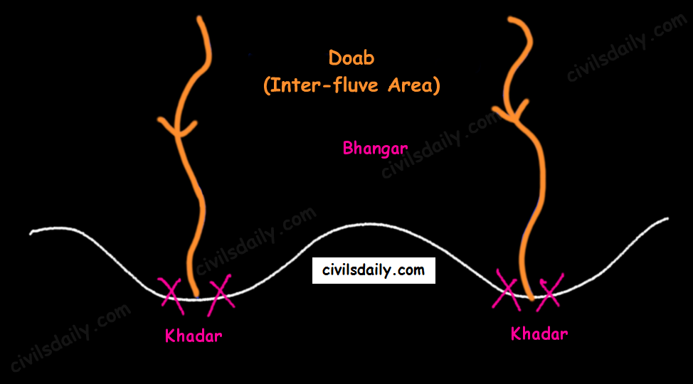
    Samanvaya: Free 1-to-1 mentorship for UPSC IAS

    Fill up this form to schedule a free on-call discussion with senior mentor from Civilsdaily. Once submitted we will call you within 24 hours.

    Civilsdaily Samanvaya 1-On-1 Mentorship Form

    Field will not be visible to web visitor

  • [RSTV Archive] Judiciary & Artificial Intelligence

    UPSC 2022 countdown has begun! Get your personal guidance plan now! (Click here)
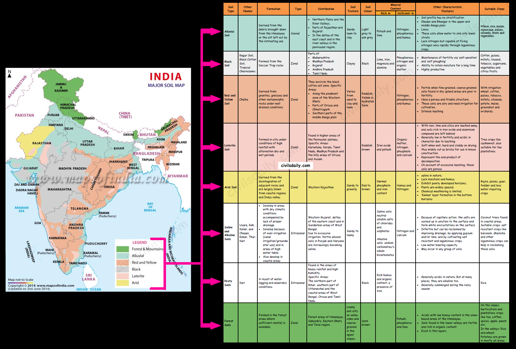
    The Supreme Court’s Artificial Intelligence Committee a few months back in April has launched its Artificial Intelligence portal SUPACE.

    What is SUPACE?

    • SUPACE is an acronym for Supreme Court Portal for Assistance in Courts Efficiency.
    • It is a blend of human and artificial intelligence, and as clarified by Bobde, will not be used in decision-making.
    • The role of AI will be limited to the collection and analysis of data.
    • The courts fully retains the autonomy and the discretion of the judge in deciding the case, though at a much, much faster pace because of the readiness with which the information is made available by the AI.

    Salient features of SUPACE

    • SUPACE facts and arguments relevant to judging a particular case are intelligently presented in a matter of seconds—done manually, this would have taken months—adjudication could become that much faster.
    • SUPACE is customizable, that is, it can behave uniquely like an individual user, learning from and mirroring user behaviour; to illustrate, imagine a system that learns to glean relevant data and present it in a structure that a judge/legal researcher finds easy to comprehend or present.
    • As it is with all AI, as the system ‘learns’, efficiency leaps exponentially.
    • The SUPACE system also includes a chatbot that can give the overview of a case, respond to elementary questions, while switching between documents and prompting further questions to sharpen the user’s understanding of a case.

    Need for AI in Judiciary

    • India’s judiciary is mired in backlogs.
    • According to the data available with the National Judicial Data Grid, around 3.81 crore cases are pending in India and more than one lakh cases have been pending for more than 30 years.

    Other such initiatives

    • SCI-Interact: In 2020, the Supreme Court developed a software called, SCI-Interact, to make all its 17 benches paperless. This software helps judges access files, annexures to petitions and make notes on computers.
    • LIMBS: Earlier, the Department of Legal Affairs has introduced a web-based application called LIMBS or Legal Information Management & Briefing System. The idea is to track the entire life cycle of a case efficiently.
    • SUVAAS: In November 2019, the Apex Court launched an indigenously engineered neural translation tool, SUVAAS, to translate judicial orders and rulings from English to vernacular languages faster and efficiently.

    Global IT solutions in Judiciary

    • The criminal justice system of the US uses algorithms to estimate the risks of habitual offence.
    • Many courts in the country are also actively embracing online dispute resolution (ODR) initiatives.
    • Unsurprisingly, China has also been adopting AI in the judiciary. The country reportedly has more than 100 robots in courts to recover case histories.

    Applications of AI in Judiciary

    • AI could be used in cases of a repetitive nature that fit a strict pattern such as bouncing of cheques, civil violations or drunk driving.
    • Pre-judicial work, such as case management, random allocation of matters to benches, case-law indexing and analysis, administrative work linked to a court can lean on AI to streamline and reduce pendency.
    • Judging involves human emotions too. No scientific tool has any moral issue attached to it, said Justice Srikrishna who helmed the study for India’s data protection policy.
    • AI has not been programmed to delve into human emotions.

    Debate over SUPACE

    • SUPACE has opened up a debate of sorts on how much AI can be used to dispense justice.
    • The core job of a judge is judging. That cannot be outsourced, said former Supreme Court judge B N Srikrishna.
    • Nuances of judging a person’s state of mind are beyond a bot, said jurists.
    • Judicial work cannot be handed over to a machine, even one with AI or programmed to read and understand law, said Justice Srikrishna.

    Limitations of SUPACE

    • For now, in India, SUPACE will be used for administrative purposes and not decision making.
    • Automated fairness is not possible to be achieved because ML-based systems do not know how to explain or digest the information they learn.
    • A mere idealistic approach to estimate things would not take the initiative further.

    Possible applications of SUPACE

    • AI has abilities to identify fact patterns easily and compare them with precedents.
    • Traffic violations and drunken driving cases or some civic violations can be dealt with by AI.

    Way forward

    • The ethical and responsible use of AI and ML for the advancement of efficiency enhancing can be increasingly embedded in legal and judicial processes.
    • The Supreme Court has laid a strong foundation basis which efficiency enhancement can be accelerated across functional processes.
    • This is one of the key reasons why justice delivery in India is poised for transformative change.

    Conclusion

    • SUPACE will produce results customized to the need of the case and the way the judge thinks.
    • This will be time-saving. It will help the judiciary and the court in reducing delays and pendency of cases.
    • AI will present a more streamlined, cost-effective and time-bound means to the fundamental right of access to justice.
    • It will make the service delivery mechanism transparent and cost-efficient.
  • Physiographic Divisions of India


    UPSC 2022 countdown has begun! Get your personal guidance plan now! (Click here)

    31 Aug 2021

    Let’s begin with the first physiographic division. It consists of:

    • THE HIMALAYAS, and
    • The Northeastern hills (Purvanchal).

    A) The Himalayas:

    The Himalayas are the highest and longest of all young fold mountains of the world. The Pamir, known as the roof of the world, connects the Himalayas with the high ranges of Central Asia.

    Let’s begin by understanding how the Himalayas came into being:

    About 40 to 50 million years ago, two large landmasses, India and Eurasia, driven by plate movement, collided. As a result, the sediments accumulated in Tethys Sea (brought by rivers) were compressed, squeezed and series of folds were formed, one behind the other, giving birth to folded mountains of the Himalayas.

    Recent studies show that India is still moving northwards at the rate of 5cm/year and crashing into the rest of Asia, thereby constantly increasing the height of Himalayas.

    The North-South division of the Himalayas

    The Himalayas consist of a series of parallel mountain ranges:

    1. The Greater Himalayan range, which includes:
      • The Great Himalayas(Himadri), and
      • The Trans-Himalayan range
    2. The Lesser Himalayas (or Himachal), and
    3. The Outer Himalayas (or Shiwalik).
    • Formation of these ranges: The Himadri and Himachal ranges of the Himalayas have been formed much before the formation of Siwalik range. The rivers rising in the Himadri and Himachal ranges brought gravel, sand and mud along with them, which was deposited in the rapidly shrinking Tethys Sea. In the course of time, the earth movements caused the folding of these relatively fresh deposits of sediments, giving rise to the least consolidated Shiwalik range.
    • Characteristic Features:
      • Notice in the map shown above that the Himalayas form an arcuate curve which is convex to the south. This curved shape of the Himalayas is attributed to the maximum push offered at the two ends on the Indian peninsula during its northward drift. In the north-west, it was done by Aravalis and in the Northeast by the Assam ranges.
      • Syntaxis/ Syntaxial bends: The gently arching ranges of the Himalayan mountains on their Western and Eastern extremities are sharply bent southward in deep Knee-bend flexures that are called syntaxial bends. On both the ends, the great mountains appear to bend around a pivotal point. The western point is situated south of the Pamir where the Karakoram meets the Hindu Kush. A similar sharp, almost hairpin bend occurs on the eastern limit of Arunachal Pradesh where the strike of the mountain changes sharply from the Easterly to Southerly trend. Besides these two major bends, there are a number of minor syntaxial bends in other parts of Himalayas.
        Syntaxial Bends of Himalayas
      • The Himalayas are wider in the west than in the east. The width varies from 400 km in Kashmir to 150 km in Arunachal Pradesh. The main reason behind this difference is that the compressive force was more in the east than in the west. That is why high mountain peaks like Mount Everest and Kanchenjunga are present in the Eastern Himalayas.
      • The ranges are separated by deep valleys creating a highly dissected topography.
      • The southern slopes of the Himalayas facing India are steeper and those facing the Tibetan side are generally gentler.
    • Let’s take up these Himalayan mountain ranges one by one:   The Himalayan Ranges | the Greater Himalayan Range, the Lesser Himalayas, the Shivaliks Indus-Tsangpo Suture Zone: It represents a belt of tectonic compression caused by the underthrusting of the Indian shield/ plate against the Tibetan mass. It marks the boundary between the Indian and Eurasian plates. The suture zone stretches from the North-Western Himalayan syntaxis bordering the Nanga Parbat to the East as far as the Namche Barwa Mountain. The Karakoram Range and the Ladakh plateau lie to the north of ITSZ and originally formed a part of the European plate. Main Central Thrust Zone: This separates the Higher Himalayas in the north from lesser Himalayas in the south. It has played an important role in the tectonic history of these mountains. Main Boundary Thrust: It is a reverse fault of great dimensions which extends all the way from Assam to Punjab and serves to separate the outer Himalayas from the lesser Himalayas.Himalayan Frontal Fault: It is a series of reverse faults that demarcates the boundary of the Shivalik from of the Himalayan province from the alluvial expanse of the Indo-Gangetic plains.
    Major Faults of the Himalayas – ITSZ, MCT, MBT, HFF
    The Himalayan Complex: A Cross-sectional View  

    Besides the longitudinal divisions, the Himalayas have been divided on the basis of regions from west to east:

    These divisions have been demarcated by river valleys:

    The Regional Divisions of Himalayas – the Western and Eastern Himalayas.
    1. Punjab Himalayas:
      • A large portion of Punjab Himalayas is in Jammu and Kashmir and Himachal Pradesh. Hence they are also called the Kashmir and Himachal Himalaya.
      • Major ranges: Karakoram, Ladakh, Pir Panjal, Zaskar and Dhaola Dhar.
      • The general elevation falls westwards.
      • The Kashmir Himalayas are also famous for Karewa formations.
        • ‘Karewas’ in Kashmiri language refer to the lake deposits, found in the flat-topped terraces of the Kashmir valley and on the flanks of the Pir Panjal range.
        • These deposits consist of clays, silts and sands, these deposits also show evidence of glaciation.
        • The occurrence of tilted beds of Karewas at the altitudes of 1500-1800m on the flanks of the Pir Panjal strongly suggests that the Himalayas were in process of uplift as late as Pliocene and Pleistocene (1.8mya to 10kyears ago)
        • Karewas are famous for the cultivation of Zafran, a local variety of saffron.
    2. Kumaon Himalayas
    3. Nepal Himalayas:
      • Tallest section of Himalayas
    4. Sikkim Himalayas:
      • Teesta river originates near Kanchenjunga
      • Jelep la pass- tri-junction of India- China-Bhutan
    5. Assam Himalayas:
      • The Himalayas are narrower in this region and Lesser Himalayas lie close to Great Himalayas.
      • Peaks: Namcha Barwa, Kula Kangri
      • Bengal ‘Duars’
      • Diphu pass- tri-junction of India- China-Myanmar
      • The Assam Himalayas show a marked dominance of fluvial erosion due to heavy rainfall.
    The West-East Division of Himalayas

    Glaciers and Snowline:

    Snowline: The lower limit of perpetual snow is called the ‘snowline’. The snowline in the Himalayas has different heights in different parts, depending on latitude, altitude, amount of precipitation, moisture, slope and local topography.

    1. The snowline in the Western Himalaya is at a lower altitude than in the Eastern Himalaya. E.g. while the glaciers of the Kanchenjunga in the Sikkim portion hardly move below 4000m, and those of Kumaon and Lahul to 3600m, the glaciers of the Kashmir Himalayas may descend to 2500m above the sea level.

    • It is because of the increase in latitude from 28°N in Kanchenjunga to 36°N in the Karakoram (Lower latitude —> warmer temperatures —> higher snowline).
    • Also, the Eastern Himalayas rise abruptly from the planes without the intervention of High ranges.
    • Though the total precipitation is much less in the western Himalayas, it all takes place in the form of snow.

    2. In the Great Himalayan ranges, the snowline is at a lower elevation on the southern slopes than on the northern slopes. This is because the southern slopes are steeper and receive more precipitation as compared to the northern slopes.

    Glaciers: The main glaciers are found in the Great Himalayas and the Trans-Himalayan ranges (Karakoram, Ladakh and Zaskar). The Lesser Himalayas have small glaciers, though traces of large glaciers are found in the Pir Panjal and Dhauladhar ranges. Some of the important glaciers are:

    Important Glaciers and their Locations

    Key differences between the Eastern and Western Himalayas:

    Key Difference between the Western and Eastern Himalayas.

    Important Passes in India:

    A pass is a narrow gap in a mountain range which provides a passageway through the barrier.

    Important Passes in India
    1. Pir Panjal Pass – It provides the shortest and the easiest metal road between Jammu and the Kashmir Valley. But this route had to be closed down as a result of partition of the subcontinent.
    2. Banihal Pass – It is in Jammu and Kashmir. The road from Jammu to Srinagar transversed Banihal Pass until 1956 when Jawahar Tunnel was constructed under the pass. The road now passes through the tunnel and the Banihal Pass is no longer used for road transport.
    3. Zoji La (Pass) – It is in the Zaskar range of Jammu and Kashmir. The land route from Srinagar to Leh goes through this pass.
    4. Shipki La (Pass) – It is in Himachal Pradesh. The road from Shimla to Tibet goes through this pass. The Satluj river flows through this pass.
    5. Bara Lacha Pass – It is also in Himachal Pradesh. It links Mandi and Leh by road.
    6. Rohtang Pass – It is also in Himachal Pradesh. It cuts through the Pir Panjal range. It links Manali and Leh by road.
    7. Niti Pass – It is in Uttarakhand. The road to the Kailash and the Manasarovar passes through it.
    8. Nathu La (Pass) – It is in Sikkim. It gives way to Tibet from Darjeeling and Chumbi valley. The Chumbi river flows through this pass.
    9. Jalep La (Pass) – At the tri-junction of India- China-Bhutan. The Teesta river has created this pass.

    B) The North-Eastern Hills and Mountains

    The North-Eastern Hills (Purvanchal): Patkai Bum, Naga Hills, Mizo Hills

    The Brahmaputra marks the eastern border of Himalayas. Beyond the Dihang gorge, the Himalayas bend sharply towards the south and form the Eastern hills or Purvanchal.

    • These hills run through the northeastern states of India.
    • These hills differ in scale and relief but stem from the Himalayan orogeny.
    • They are mostly composed of sandstones (i.e. Sedimentary rocks).
    • These hills are covered with dense forests.
    • Their elevation decreases from north to south. Although comparatively low, these hill ranges are rather forbidding because of the rough terrain, dense forests and swift streams.
    • Purvanchal hills are convex to the west.
    • These hills are composed of:
      • Patkai Bum – Border between Arunachal Pradesh and Myanmar
      • Naga Hills
      • Manipuri Hills – Border between Manipur and Myanmar
      • Mizo Hills.
    • Patkai Bum and Naga Hills form the watershed between India and Myanmar.
    • Extension of Purvanchal continues in Myanmar as Arakan Yoma –then Andaman and Nicobar Islands.
    Arakan Yoma – An Extension of Purvanchal in Myanmar

    The importance of Himalayan Region:

    1. Climatic Influence – The altitude of the Himalayas, their sprawl and extension intercept the summer monsoon. They also prevent the cold Siberian air masses from entering into India.
    1. Defence
    2. Source of perennial rivers
    3. Source of fertile soils
    4. Generation of hydroelectricity
    5. Forest wealth
    6. Orchards
    7. Minerals – The Himalayan region is rich in minerals e.g. gold, silver, copper, lead etc. are known to occur. Coal is found in Kashmir. But at the present level of technological advancement, it is not possible to extract these minerals. Also, it is not economically viable.
    8. Tourism
    9. Pilgrimage

    NORTHERN PLAINS

    Location and Extent:

    Northern plains are the youngest physiographic feature in India. They lie to the south of the Shivaliks, separated by the Himalayan Frontal Fault (HFF). The southern boundary is a wavy irregular line along the northern edge of the Peninsular India. On the eastern side, the plains are bordered by the Purvanchal hills.

    The Physiographic Divisions of India: the Northern Plains

    Formation of Northern Plains:

    Due to the uplift of the Himalayas in the Tethys Sea, the northern part of the Indian Peninsula got subsided and formed a large basin.

    northern-plains
    Source

    That basin was filled with sediments from the rivers which came from the mountains in the north and from the peninsula in the south. These extensive alluvial deposits led to the formation of the northern plains of India.

    Chief Characteristics:

    • The northern plain of India is formed by three river systems, i.e. the Indus, the Ganga and the Brahmaputra; along with their tributaries.
    • The northern plains are the largest alluvial tract of the world. These plains extend approximately 3200 km from west to east.
    • The average width of these plains varies between 150 and 300 km. In general, the width of the northern plains increases from east to west (90-100km in Assam to about 500km in Punjab).
    • The exact depth of alluvium has not yet been fully determined. According to recent estimates, the average depth of alluvium in the southern side of the plain varies between 1300-1400m, while towards the Shiwaliks, the depth of alluvium increases. The maximum depth of over 8000m has been reached in parts of Haryana.
    • The extreme horizontality of this monotonous plain is its chief characteristic (200m – 291m). The highest elevation of 291 m above mean sea level near Ambala forms a watershed between the Indus system and Ganga system).
    • The monotony of the physical landscape is broken at the micro-level by the river bluffs, levees etc.
      • [Floodplain – That part of a river valley, adjacent to the channel, over which a river flows in times of a flood.
      • Levee – An elevated bank flanking the channel of the river and standing above the level of the flood plain.
      • Bluff – A river cut cliff or steep slope on the outside of a meander. A line of bluffs often marks the edge of a former floodplain.]
    slide_34
    Source

    Physiographic Divisions of the Northern Plains:

    From the north to the south, the northern plains can be divided into three major zones:

    1. The Bhabar
    2. The Tarai
    3. The alluvial plains.

    The alluvial plains can be further divided into the Khadar and the Bhangar as illustrated below:

    Geomorphology of the Northern Plains

    Let’s understand these divisions one by one:

    Bhabar:

    • Bhabar is a narrow belt (8-10km wide) which runs in the west-east direction along the foot of the Himalayas from the river Indus to Teesta.
      Source
    • Rivers which descend from the Himalayas deposit their load along the foothills in the form of alluvial fans.
    • These fans consisting of coarser sediments have merged together to build up the piedmont plain/the Bhabar.
    • The porosity of the pebble-studded rock beds is very high and as a result, most of the streams sink and flow underground. Therefore, the area is characterized by dry river courses except in the rainy season.
    • The Bhabar track is not suitable for cultivation of crops. Only big trees with large roots thrive in this region.
    • The Bhabar belt is comparatively narrow in the east and extensive in the western and north-western hilly region.

    Tarai:

    • It is a 10-20 km wide marshy region in the south of Bhabar and runs parallel to it.
    • The Tarai is wider in the eastern parts of the Great Plains, especially in the Brahmaputra valley due to heavy rainfall.
    • It is characterized by the re-emergence of the underground streams of the Bhabar belt.
    • The reemerged water transforms large areas along the rivers into badly drained marshy lands.
    • Once covered with dense forests, most of the Tarai land (especially in Punjab, Uttar Pradesh and Uttarakhand) has been reclaimed and turned into agricultural land over a period of time.

    Bhangar:

    • It is the older alluvium along the river beds forming terraces higher than the flood plain.
    • Dark in colour, rich in humus content and productive.
    • The soil is clayey in composition and has lime modules (called kankar)
    • Found in doabs (inter-fluve areas)
    • ‘The Barind plains’ in the deltaic region of Bengal and the ‘bhur formations’ in the middle Ganga and Yamuna doab are regional variations of Bhangar. [Bhur denotes an elevated piece of land situated along the banks of the Ganga river especially in the upper Ganga-Yamuna Doab. This has been formed due to accumulation of wind-blown sands during the hot dry months of the year]
    • In relatively drier areas, the Bhangar also exhibits small tracts of saline and alkaline efflorescence known as ‘Reh’, ‘Kallar’ or ‘Bhur’. Reh areas have spread in recent times with an increase in irrigation (capillary action brings salts to the surface).
    • May have fossil remains of even those plants and animals which have become extinct.

    Khadar:

    • Composed of newer alluvium and forms the flood plains along the river banks.
    • Light in colour, sandy in texture and more porous.
    • Found near the riverbeds.
    • A new layer of alluvium is deposited by river flood almost every year. This makes them the most fertile soils of Ganges.
    • In Punjab, the Khadar rich flood plains are locally known as ‘Betlands’ or ‘Bets’.
    • The rivers in Punjab-Haryana plains have broad flood plains of Khadar flanked by bluffs, locally known as Dhayas. These bluffs are as high as 3metres.

    Northern Plain: Regional Divisions

    The Regional Divisions of the Northern Plains: Punjab, Ganga and the Brahmaputra Plains.

    1. Punjab Plains:
    • The Punjab plains form the western part of the northern plain.
    • In the east, the Delhi-Aravalli ridge separates it from the Ganga plains.
    • This is formed by the Indus and its tributaries; like Jhelum, Chenab, Ravi, Beas and Sutlej. A major portion of these plains is in Pakistan.
    • It is divided into many Doabs (do-“two” + ab- “water or river” = “a region or land lying between and reaching to the meeting of the two rivers”).
        Khadar and Bhangar
    • Important features:
      • Khadar rich flood plains known as ‘Betlands’ or ‘Bets’.
      • The rivers in Punjab-Haryana plains have broad flood plains of Khadar flanked by bluffs, locally known as Dhayas.
      • The northern part of this plane adjoining the Shivalik hills has been heavily eroded by numerous streams, which are called Chhos.
      • The southwestern parts, especially the Hisar district is sandy and characterized by shifting sand-dunes.
    1. Ganga Plains:
    • The Ganga plains lie between the Yamuna catchment in the west to the Bangladesh border in the East.
    • The lower Ganga plain has been formed by the down warping of a part of Peninsular India between Rajmahal hills and the Meghalaya plateau and subsequent sedimentation by the Ganga and Brahmaputra rivers.
    • The main topographical variations in these plains include Bhabar, Tarai, Bhangar, Khadar, levees, abandoned courses etc.
    • Almost all the rivers keep on shifting their courses making this area prone to frequent floods. The Kosi river is very notorious in this respect. It has long been called the ‘Sorrow of Bihar’.
    • The northern states, Haryana, Delhi, UP, Bihar, part of Jharkhand and West Bengal in the east lie in the Ganga plains.
    • The Ganga-Brahmaputra delta: the largest delta in the world. A large part of the coastal delta is covered tidal forests called Sunderbans. Sunderbans, the largest mangrove swamp in the world gets its name from the Sundari tree which grows well in marshland. It is home to the Royal Tiger and crocodiles.
    1. Brahmaputra Plains:
    • This plain forms the eastern part of the northern plain and lies in Assam.
    • Its western boundary is formed by the Indo-Bangladesh border as well as the boundary of the lower Ganga Plain. Its eastern boundary is formed by Purvanchal hills.
    • The region is surrounded by high mountains on all sides, except on the west.
    • The whole length of the plain is traversed by the Brahmaputra.
    • The Brahmaputra plains are known for their riverine islands (due to the low gradient of the region) and sand bars.
    • The innumerable tributaries of the Brahmaputra river coming from the north form a number of alluvial fans. Consequently, the tributaries branch out in many channels giving birth to river meandering leading to the formation of bill and ox-bow lakes.
    • There are large marshy tracts in this area. The alluvial fans formed by the coarse alluvial debris have led to the formation of terai or semi-terai conditions.

    Significance of this region:

    • The plains constitute less than one-third of the total area of the country but support over 40 percent of the total population of the country.
    • Fertile alluvial soils, flat surface, slow-moving perennial rivers and favourable climate facilitate an intense agricultural activity.
    • The extensive use of irrigation has made Punjab, Haryana and western part of Uttar Pradesh the granary of India (Prairies are called the granaries of the world).
    • Cultural tourism: Several sacred places and centres of pilgrimage are situated in these plains e.g. Haridwar, Amritsar, Varanasi, Allahabad, Bodh Gaya etc.
    • The sedimentary rocks of plains have petroleum and natural gas deposits.
    • The rivers here have very gentle gradients which make them navigable over long distances.

    PENINSULAR PLATEAU

    A. Location and Extent

    • The Peninsular Plateau lies to the south of the Northern Plains of India.
    • It is bordered on all sides by the hill ranges:
    • Delhi ridge in the north-west (extension of Aravalis),
    • the Rajmahal Hills in the east,
    • Gir range in the west, and
    • the Cardamom Hills in the south constitute the outer extent of the peninsular plateau.
    The Physiographic Divisions of India | The Peninsular Plateau
    • Outlier:
      • Shillong and Karbi-Anglong plateau.

    Note: Kutchch Kathiawar region – The region, though an extension of Peninsular plateau (because Kathiawar is made of the Deccan Lava and there are tertiary rocks in the Kutch area), they are now treated as an integral part of the Western Coastal Plains as they are now levelled down.

    • The Garo-Rajmahal Gap:
      • The two disconnected outlying segments of the plateau region are seen in the Rajmahal and Garo-Khasi Jaintia hills.
      • It is believed that due to the force exerted by the northeastward movement of the Indian plate at the time of the Himalayan origin, a huge fault was created between the Rajmahal hills and the Meghalaya plateau
      • Later, this depression got filled up by the deposition activity of the numerous rivers.
      • As a result, today the Meghalaya and Karbi Anglong plateau stand detached from the main Peninsular Block.

    Geological History and Features:

    The peninsular plateau is a tableland which contains igneous and metamorphic rocks. It is one of the oldest and the most stable landmass of India.

    In its otherwise stable history, the peninsula has seen a few changes like:

    1. Gondwana Coal Formation.
    2. Narmada-Tapi rift valley formation.
    3. Basalt Lava eruption on Deccan plateau:

    During its journey northward after breaking off from the rest of Gondwana, the Indian Plate passed over a geologic hotspot, the Réunion hotspot, which caused extensive melting underneath the Indian Craton. The melting broke through the surface of the craton in a massive flood basalt event, creating what is known as the Deccan Traps (Its various features have been discussed in the later portion of the article).

    Chief Characteristics:

    The entire peninsular plateau region is an aggregation of several smaller plateaus and hill ranges interspersed with river basins and valleys. The Chhattisgarh plain occupied by the dense Dandakaranya forests is the only plain in the peninsula.

    1. General elevation and flow of rivers:

    • The average elevation is 600-900 metres.
    • The general elevation of the plateau is from the west to the east, which is also proved by the pattern of the flow of rivers.
    • Barring Narmada and Tapti all the major rivers lying to the south of the Vindhyas flow eastwards to fall into the Bay of Bengal.
    • The westward flow of Narmada and Tapi is assigned to the fact that they have been flowing through faults or rifts which were probably caused when the Himalayas began to emerge from the Tethys Sea of the olden times.

    2. Some of the important physiographic features of this region are:

    • Tors – Prominent, isolated mass of jointed, weathered rock, usually granite.
    A granite tor near Ranchi
    A granite tor near Ranchi
    • Block Mountains and Rift Valleys:
    • Spurs: A marked projection of land from a mountain or a ridge
    spur
    Image Source
    • Bare rocky structures,
    • Series of hummocky hills and wall-like quartzite dykes offering natural sites for water storage.
    • Broad and shallow valleys and rounded hills
    • Ravines and gorges: The northwestern part of the plateau has a complex relief of ravines and gorges. The ravines of Chambal, Bhind and Morena are some of the well-known examples.

    3. The Deccan Traps:

    • One of the most important features of the peninsular plateau is the black soil area in the western and northwestern part of the plateau, which is known as the Deccan Trap.
    • From the end of the Cretacious until the beginning of the Eocene, numerous fissure-type eruptions took place in the north-western part of the Deccan plateau. It is believed that the lava outpourings were more than the mass comprising the present-day Himalayas.
    • It covers a major portion of the Maharashtra plateau and parts of Gujarat, northern Karnataka and Malwa plateau. Some parts of Tamil Nadu, Andhra Pradesh, UP, and Jharkhand have some outliers of Deccan trap.
    • Basalt is the main rock of the region.
    • The region has black cotton soil as a result of weathering of this lava material and this soil is one of the finest examples of the parent material controlled soils.

    Physiographic Divisions:

    On the basis of prominent relief features, the peninsular plateau can be divided into three broad groups:

    • The Central Highlands
    • The Deccan Plateau
    • The Northeastern Plateau.
    Physiographic Divisions and Important Mountain Ranges of the Peninsular Plateau

    Let’s take up these divisions one by one:

    1. The Central Highlands

    • The northern segment of the peninsular plateau is known as the Central Highlands.
    • Location:
      1. North of Narmada river.
      2. They are bounded to the west by the Aravallis.
      3. Satpura ranges (formed by a series of scarped plateaus) lie in the South.
    • General Elevation: 700-1,000 m above the mean sea level and it slopes towards the north and northeastern directions.
    • These highlands consist of the:
      1. Marwar upland – to the east of Aravallis in Rajasthan
        • A rolling plain carved by Banas river. [Rolling Plain: ‘Rolling plains’ are not completely flat; there are slight rises and fall in the landform. Ex: Prairies of USA]
        • The average elevation is 250-500 m above sea level.
      2. Madhya Bharat Pathar – to the east of Marwar upland.
      3. Malwa plateau – It lies in Madhya Pradesh between Aravali and Vindhyas. It is composed of the extensive lava flow and is covered with black soils.
      4. Bundelkhand plateau – It lies along the borders of UP and MP. Because of intensive erosion, semi-arid climate and undulating area, it is unfit for cultivation.
      5. Baghelkhand plateau – It lies to the east of the Maikal range.
      6. Chhotanagpur plateau – the northeast part of Peninsular plateau.
        • It Includes Jharkhand, parts of Chhattisgarh and West Bengal.
        • This plateau consists of a series of step-like sub-plateaus (locally called peatlands – high-level plateau). It is thus famous as the Patland plateau and known as Ruhr of India.
        • Rajmahal Hills are the northeastern projection of Chhota Nagpur Plateau.
        • It is a mineral-rich plateau.
    • The extension of the Peninsular plateau can be seen as far as Jaisalmer in the West, where it has been covered by the longitudinal sand ridges and crescent-shaped sand dunes called barchans.
    • This region has undergone metamorphic processes in its geological history, which can be corroborated by the presence of metamorphic rocks such as marble, slate, gneiss, etc.
    • Most of the tributaries of the river Yamuna have their origin in the Vindhyan and Kaimur ranges. Banas is the only significant tributary of the river Chambal that originates from the Aravalli in the west.
    Physiographic Divisions of the Peninsular Plateau – the Central Highlands and the Deccan Plateau

    2. The Deccan Plateau

    • The Deccan Plateau lies to the south of the Narmada River and is shaped as an inverted triangle.
    • It is bordered by:
      1. The Western Ghats in the west,
      2. The Eastern Ghats in the east,
      3. The Satpura, Maikal range and Mahadeo hills in the north.
    • It is volcanic in origin, made up of horizontal layers of solidified lava forming trap structure with step-like appearance. The sedimentary layers are also found in between the layers of solidified lava, making it inter–trapping in structure.
    • Most of the rivers flow from west to east.
    • The plateau is suitable for the cultivation of cotton; home to rich mineral resources and a source to generate hydroelectric power.
    • The Deccan plateau can be subdivided as follows:
      1. The Maharashtra Plateau – it has typical Deccan trap topography underlain by basaltic rock, the regur.
      2. The Karnataka Plateau (also known as Mysore plateau) – divided into western hilly country region of ‘Malnad’ and plain ‘Maidan’
      3. Telangana Plateau

    3. The Northeastern Plateau:

    • The Meghalaya (or Shillong) plateau is separated from peninsular rock base by the Garo-Rajmahal gap.
    • Shillong (1,961 m) is the highest point of the plateau.
    • The region has the Garo, Khasi, Jaintia and Mikir (Rengma) hills.
    • An extension of the Meghalaya plateau is also seen in the Karbi Anglong hills of Assam.
    • The Meghalaya plateau is also rich in mineral resources like coal, iron ore, sillimanite, limestone and uranium.
    • This area receives maximum rainfall from the south-west monsoon. As a result, the Meghalaya plateau has a highly eroded surface. Cherrapunji displays a bare rocky surface devoid of any permanent vegetation cover.

    Hill ranges of the peninsula:

    Most of the hills in the peninsular region are of the relict type (residual hills). They are the remnants of the hills and horsts formed many million years ago (horst: uplifted block; graben: subsided block).

    The plateaus of the Peninsular region are separated from one another by these hill ranges and various river valleys.

    Hill Ranges of the Peninsula

    1. The Aravalli Mountain Range:

    • It is a relic of one of the oldest fold mountains of the world.
    • Its general elevation is only 400-600 m, with few hills well above 1,000 m.
    • At present, it is seen as a discontinuous ridge from Delhi to Ajmer and rising up to 1722m (Gurushikhar peak in Mount Abu) and thence southward.
    • It is known as ‘Jarga’ near Udaipur and ‘Delhi Ridge’ near Delhi.
    • Dilwara Jain Temple, the famous Jain temple is situated on Mt. Abu.

    2. Vindhyan Ranges:

    • They rise as an escarpment running parallel to the Narmada-Son valley.
    • General elevation: 300 to 650 m.
    • Most of them are made up of sedimentary rocks of ancient ages.
    • They act as a watershed between Gangetic and peninsular river systems.

    3. Satpura ranges:

    • Satpura range is a series of seven mountains (‘Sat’ = seven and ‘pura’ = mountains).
    • The seven mountain ranges or folds of Satpura’s are:
      • Maikal Hills
      • Mahadeo Hills near Pachmarhi
      • Kalibhit
      • Asirgarh
      • Bijagarh
      • Barwani
      • Arwani which extends to Rajpipla Hills in Eastern Gujarat.
    • Satpura ranges run parallel between Narmada and Tapi, parallel to Maharashtra-MP border.
    • Dhupgarh (1,350 m) near Pachmarhi on Mahadev Hills is the highest peak of the Satpura Range.
    • Amarkantak (1,127 m) is another important peak. Amarkantak is the highest peak of the Maikal Hills from where two prominent rivers – the Narmada and the Son originate.
    • Note that three rivers originate from the three sides of Maikal hills (as shown in the following map) but, from Amarkantak, only two rivers (the Narmada and the Son) originate (and not Mahanadi).
    The Satpura Mountain Range

    4. Western and Eastern Ghats:

    • The Western Ghats:
      • These are a faulted part of the Deccan plateau running parallel from the Tapi valley to a little north of Kanyakumari (1600km). Their western slope is like an escarpment while eastern slope merges gently with the plateau.
      • Their average elevation is about 1,500 m with the height increasing from north to south.
    • The Eastern Ghats are in the form of residual mountains which are not regular but broken at intervals.
    • The Eastern and the Western Ghats meet each other at the Nilgiri hills.
    • A brief comparison between them:
    Differences between the Western and Eastern Ghats.
    A cross-sectional view through the Peninsular Plateau showing sharp relief contrast between the western and eastern margins

    Note: The Western Ghats are continuous and can be crossed through passes only. There are four main passes which have developed in the Western Ghats. These are:

    1. Thal Ghat – It links Nasik to Mumbai.
    2. Bhor Ghat – It links Mumbai to Pune.
    3. Pal Ghat – This pass is located between the Nilgiris and the Annamalai mountains. It is in Kerala and connects Kochi and Chennai.
    4. Senkota Pass – This pass located between the Nagercoil and the Cardamom hills links Thiruvananthapuram and Madurai.

    For the geographical location of these passes, see the following map:

    Important Passes in India

    Significance of the Peninsular Region:

    • Rich in mineral resources: The peninsular region of India is rich in both metallic and non-metallic minerals. About 98% of the Gondwana coal deposits of India are found in the peninsular region.
    • Agriculture: Black soil found in a substantial part of the peninsula is conducive for the cultivation of cotton, maize , citrus fruits etc. Some areas are also suitable for the cultivation of tea, coffee, groundnut etc.
    • Forest Products: Apart from teal, sal wood and other forest products, the forests of Western and Eastern Ghats are rich in medicinal plants and are home to many wild animals.
    • Hydel Power: many rivers, which have waterfalls. They help in the generation of hydroelectric power.
    • Tourism: There are numerous hill stations and hill resorts like Ooty, Mahabaleshwar, Khandala, etc.

    THE INDIAN DESERT

    The Indian desert is also known as the Thar Desert or the Great Indian Desert.

    Location and Extent:

    • Location – To the north-west of the Aravali hills.
    • It covers Western Rajasthan and extends to the adjacent parts of Pakistan.
    The Physiographic Divisions of India | The Indian Desert

    Geological History and Features

    • Most of the arid plain was under the sea from Permo-Carboniferous period and later it was uplifted during the Pleistocene age. This can be corroborated by the evidence available at wood fossils park at Aakal and marine deposits around Brahmsar, near Jaisalmer (The approximate age of the wood fossils is estimated to be 180 million years).
    • The presence of dry beds of rivers (eg Saraswati) indicates that the region was once fertile.
    • Geologically, the desert area is a part of the peninsular plateau region but on the surface, it looks like an aggradational plain.

    Chief Characteristics:

    • The desert proper is called the Marusthali (dead land) as this region has an arid climate with low vegetation cover. In general, the Eastern part of the Marushthali is rocky, while its western part is covered by shifting sand dunes.
    • Bagar: Bagar refers to the semi-desert area which is west of Aravallis. Bagar has a thin layer of sand. It is drained by Luni in the south whereas the northern section has a number of salt lakes.
    • The Rajasthan Bagar region has a number of short seasonal streams which originate from the Aravallis. These streams support agriculture in some fertile patches called Rohi.
    • Even the most important river ‘Luni’ is a seasonal stream. The Luni originates in the Pushkar valley of the Aravalli Range, near Ajmer and flows towards the southwest into the Rann of Kutch.
    • The region north of Luni is known as the Thali or sandy plain.
    • There are some streams which disappear after flowing for some distance and present a typical case of inland drainage by joining a lake or playa e.g. the Sambhar Lake. The lakes and the playas have brackish water which is the main source of obtaining salt.
    • Well pronounced desert land features:
      • Sand dunes: It is a land of undulating topography dotted with longitudinal dunes, transverse dunes and barchans. [Barchan – A crescent-shaped sand dune, the horns of which point away from the direction of the dominant wind; Longitudinal dune – A sand dune with its crest running parallel to the direction of prevailing wind]
    sand-dunes
    Image Source
    • Mushroom rocks
    • Shifting dunes (locally called Dhrians)
    • Oasis (mostly in its southern part)

    THE COASTAL PLAINS

    Of the total coastline of India (7517 km), that of the peninsula is 6100 km between the peninsular plateau and the sea. The peninsular plateau of India is flanked by narrow coastal plains of varied width from north to south.

    The Physiographic Divisions of India | The Coastal Plains

    On the basis of the location and active geomorphologic processes, these can be broadly divided into two parts:

    • The western coastal plains
    • The eastern coastal plains.

    We now take them up one by one:

    The Western Coastal Plain

    1. Extent: The Western Coastal Plains are a thin strip of coastal plains with a width of 50 km between the Arabian Sea and the Western Ghats.

    2. Subdivisions: Extending from the Gujarat coast in the north to the Kerala coast in the south, the western coast may be divided into following divisions:

    • Kachchh and Kathiawar coast in Gujarat,
    • Konkan coast in Maharashtra,
    • Goan Coast in Karnataka, and
    • Malabar coast in Kerala

    Note: Kutch and Kathiawar, though an extension of Peninsular plateau (because Kathiawar is made of the Deccan Lava and there are tertiary rocks in the Kutch area), they are still treated as an integral part of the Western Coastal Plains as they are now levelled down.

    Subdivisions of the eastern and Western Coastal Plains

    3. A coastline of submergence: The western coastal plains are an example of the submerged coastal plain. It is believed that the city of Dwaraka which was once a part of the Indian mainland situated along the west coast is submerged underwater.

    4. Characteristic Features:

    • The western coastal plains are narrow in the middle and get broader towards north and south. Except for the Kachchh and Kathiawar coastal region, these are narrower than their eastern counterpart.
    • The coast is straight and affected by the South-West Monsoon winds over a period of six months. The western coastal plains are thus wetter than their eastern counterpart.
    • The western coast being more indented than the eastern coast provides natural conditions for the development of ports and harbours. Kandla, Mazagaon, JLN port Navha Sheva, Marmagao, Mangalore, Cochin, etc. are some of the important natural ports located along the west coast.
    • The western coastal plains are dotted with a large number of coves (a very small bay), creeks (a narrow, sheltered waterway such as an inlet in a shoreline or channel in a marsh) and a few estuaries. The estuaries, of the Narmada and the Tapi are the major ones.
    • The rivers flowing through this coastal plain do not form any delta. Many small rivers descend from the Western Ghats making a chain of waterfalls.
    • The Kayals – The Malabar coast has a distinguishing feature in the form of ‘Kayals’ (backwaters). These backwaters are the shallow lagoons or the inlets of the sea and lie parallel to the coastline. These are used for fishing, inland navigation and are important tourist spots. The largest of these lagoons is the Vembanad lake. Kochi is situated on its opening into the sea.

    The Eastern Coastal Plain

    1. Extent: The Eastern Coastal Plains is a strip of coastal plain with a width of 100 – 130 km between the Bay of Bengal and the Eastern Ghats

    2. Subdivisions: It can be divided into two parts:

    • Northern Circar: The northern part between Mahanadi and Krishna rivers. Additionally, the coastal tract of Odisha is called the Utkal plains.
    • Coromandel Coast (or Payan Ghat): The southern part between Krishna and Kaveri rivers.

    3. A coastline of emergence: The eastern coastal plain is broader and is an example of an emergent coast.

    4. Characteristic features:

    • The eastern coastal plains are wider and drier resulting in shifting sand dunes on its plains.
    • There are well-developed deltas here, formed by the rivers flowing eastward in to the Bay of Bengal. These include the deltas of the Mahanadi, the Godavari, the Krishna and the Kaveri.
    • Because of its emergent nature, it has less number of ports and harbours. The continental shelf extends up to 500 km into the sea, which makes it difficult for the development of good ports and harbours.
    • Chilika lake is an important feature along the eastern coast. It is the largest saltwater lake in India.

    Significance of the Coastal Plains region:

    1. These plains are agriculturally very productive. The western coast grows specialized tropical crops while eastern coasts witnessed a green revolution in rice.
    2. The delta regions of eastern coastal plains have a good network of canals across the river tributaries.
    3. Coastal plains are a source of salt, monazite (used for nuclear power) and mineral oil and gas as well as centres of fisheries.
    4. Although lacking in adequate natural harbours, with a number of major and minor ports, coastal plains are centres of commerce and have attracted dense human settlements.
    5. The coastal regions of India are noted for tourist centres, fishing and salt making.

    THE ISLANDS

    There are two major island groups in India

    1. The island groups of Bay of Bengal: Andaman & Nicobar Islands
    2. The island groups of Arabian Sea: Lakshadweep and Minicoy Islands
    The Physiographic Divisions of India | The Islands

    Let’s take these up one by one:

    Andaman & Nicobar Islands:

    • Also called the emerald islands.
    • Location and Extent:
      • These are situated roughly between 6°N-14°N and 92°E -94°E.
      • The most visible feature of the alignment of these islands is their narrow longitudinal extent.
      • These islands extend from the Landfall Island in the north (in the Andamans) to the Indira Point (formerly known as Pygmalion Point and Parsons Point) in the south (In the Great Nicobar).
    • Origin: The Andaman and Nicobar islands have a geological affinity with the tertiary formation of the Himalayas, and form a part of its southern loop continuing southward from the Arakan Yoma.
    • The entire group of islands is divided into two broad categories:
      • The Andaman in the north, and
      • The Nicobar in the south.

    They are separated by a water body which is called the Ten-degree channel.

    • The Andaman islands are further divided into:
      • Great Andamans
        • North Andaman
        • Middle Andaman
        • South Andaman
      • Little Andaman

    Little Andaman is separated from the Great Andamans by the Duncan Passage.

    The Andaman and Nicobar Islands
    • Chief Characteristics:
      • These are actually a continuation of Arakan Yoma mountain range of Myanmar and are therefore characterized by hill ranges and valleys along with the development of some coral islands.
      • Some smaller islands are volcanic in origin e.g. the Barren island and the Narcondam Island. Narcondam is supposed to be a dormant volcano but Barren perhaps is still active.
      • These islands make an arcuate curve, convex to the west.
      • These islands are formed of granitic rocks.
      • The coastal line has some coral deposits and beautiful beaches.
      • These islands receive convectional rainfall and have an equatorial type of vegetation.
      • These islands have a warm tropical climate all year round with two monsoons.
      • The Saddle peak (North Andaman – 738 m) is the highest peak of these islands.
      • The Great Nicobar is the largest island in the Nicobar group and is the southernmost island. It is just 147 km away from the Sumatra island of Indonesia.

    Lakshadweep Islands:

    • These islands were earlier (before 1st November 1973) known as Laccadive, Minicoy and Amindivi Islands.
    • Location:
      • These are scattered in the Arabian Sea between 8°N-12°N and 71°E -74°E longitude.
      • These islands are located at a distance of 280 km-480 km off the Kerala coast.
    • Origin: The entire island group is built of coral deposits.
    • Important islands:
      • Amindivi and Cannanore islands in the north.
      • Minicoy (lies to the south of the nine-degree channel) is the largest island with an area of 453 sq. km.
    map_of_lakshadweep-en-svg
    Source
    • Chief Characteristics:
      • These consist of approximately 36 islands of which 11 are inhabited.
      • These islands, in general, have a north-south orientation (only Androth has an East-West orientation.
      • These islands are never more than 5 metres above sea level.
      • These islands have calcium-rich soils- organic limestones and scattered vegetation of palm species.
      • One typical feature of these islands is the formation of the crescentic reef in the east and a lagoon in the west.
      • Their eastern seaboard is steeper.
      • The Islands of this archipelago have storm beaches consisting of unconsolidated pebbles, shingles, cobbles and boulders on the eastern seaboard.
      • The islands form the smallest Union Territory of India.

    Other than the above mentioned two major groups, the important islands are:

    1. Majauli: in Assam. It is:
      1. The world’s largest freshwater (Brahmaputra river) island.
      2. India’s first island district
    2. Salsette: India’s most populous island. Mumbai city is located on this island.
    3. Sriharikota: A barrier island. On this island is located the satellite launching station of ISRO.
    4. Aliabet: India’s first off-shore oil well site (Gujarat); about 45 km from Bhavnagar, it is in the Gulf of Khambat.
    5. New Moore Island: in the Ganga delta. It is also known as Purbasha island. It is an island in the Sunderban deltaic region and it was a bone of contention between India and Bangladesh. In 2010, it was reported to have been completely submerged by the rising seawater due to Global warming.
    6. Pamban Island: lies between India and Sri Lanka.
    7. Abdul Kalam Island: The Wheeler Island near the Odisha coast was renamed as Abdul Kalam island in 2015. It is a missile launching station in the Bay of Bengal. The first successful land-to-land test of the Prithvi Missile was conducted from the mainland and it landed on the then uninhabited ‘Wheeler Island’ on November 30, 1993.

    UPSC 2022 countdown has begun! Get your personal guidance plan now! (Click here)

    Samanvaya: Free 1-to-1 mentorship for UPSC IAS

    Fill up this form to schedule a free on-call discussion with senior mentor from Civilsdaily. Once submitted we will call you within 24 hours.

    Civilsdaily Samanvaya 1-On-1 Mentorship Form

    Field will not be visible to web visitor