IoT is the network of physical devices, vehicles, home appliances and other items embedded with electronics, software, sensors, actuators, and connectivity which enables these objects to connect and exchange data
Each thing is uniquely identifiable through its embedded computing system but is able to inter-operate within the existing Internet infrastructure
The IoT allows objects to be sensed or controlled remotely across existing network infrastructure
When IoT is augmented with sensors and actuators, the technology becomes an instance of the more general class of cyber-physical systems, which also encompasses technologies such as smart grids, virtual power plants, smart homes, intelligent transportation and smart cities
Real Estate Investment Trusts or REITs are mutual funds like institutions that enable investments in the real estate sector
This is done by pooling small sums of money from a multitude of individual investors for directly investing in real estate properties so as to return a portion of the income (after deducting expenditures) to unitholders of REITs, who pooled in the money
A REIT in India is allowed to invest mainly in completed and revenue generating assets and other approved investments
REIT will have to distribute the majority of its income among the unit holders
REITs are set up as a trust under the provisions of the Indian Trusts Act, 1882
Like a mutual fund, it has three parties – Trustee, Sponsor(s) and Manager – to avoid any conflict of interest issues
REITs are regulated by the securities market regulator in India- Securities and Exchange Board of India (SEBI)
Link for the test: Click2Attempt (Let us know your score in comments)
We have started our Open SIP program in conjunction with our PAID program (Click2Know all details of the program)
We will be running this special FREE initiative on daily basis providing students with revision questions for static subjects as well as current affairs starting from June 2017
Liked the test? You can join our FLT program containing more such high-level questions. The module contains 11 FLTs (8 paper 1 TS + 3 CSAT)
Know all details about the program and join here: Click2Join
Want to do quick revision for Prelims? Join our SIP Comprehensive or SIP Mini modules giving you Static & Dynamic subjects coverage through video lectures
Recently in News because : Justice Dalveer Bhandari was re-elected as a judge at the International Court of Justice (ICJ),making him the third Indian to secure a prominent position in a United Nations (UN) body in recent months
Objective : Settle legal disputes submitted to it by states, duly authorized international branches, agencies, and the UN General Assembly
Members : The International Court of Justice is composed of 15 judges elected to nine-year terms of office by the United Nations General Assembly and the Security Council
The geological structure of a country helps in understanding the types and character of rocks and slopes, the physical and chemical properties of soils, the availability of minerals, and the surface and underground water resources. But before we can study the geological structure of India, it is important that we understand what a geological time scale means:
The Geological Timescale
When did the dinosaurs get extinct? When did the birds first appear on earth? What about the beginning of life itself?
To answer these questions, geologists use a special timeline called the Geological Time Scale. It is a record of Earth’s Geologic history based on radiometric dating and the record of ancient life preserved in layers of rocks.
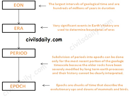
The geological timescale is broken up into larger and smaller subdivisions which help us understand how the various historical events fit together. These time intervals are not equal in length like the hours in a day. Instead, the time intervals are variable in length because geologic time is divided using significant events in the history of the Earth. The various intervals are:
Subdivisions of the Geological timescale
Let’s watch a video to understand this division better:
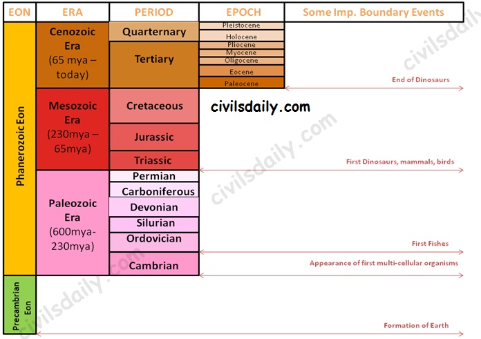
The geological timescale thus looks like:
The Geological Timescale
Note: Due to lack of sufficient information about the Precambrian Eon, there is no subdivision into eras etc. At the same time, it is important to note that the Precambrian time constitutes about 86.7% of Earth’s history.
The Indian Geological History:
Major events in the geological history of India:
Peninsular India was a part of the old landmass since the formation of the Earth’s Crust
The upheaval of Himalayas in the tertiary period.
Aggradational formation of the Indo-Gangetic plain during the Pleistocene period. It continues till today through sedimentation in the floodplains of the rivers and the lower part of the Gangetic plain.
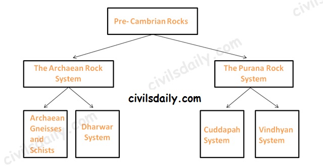
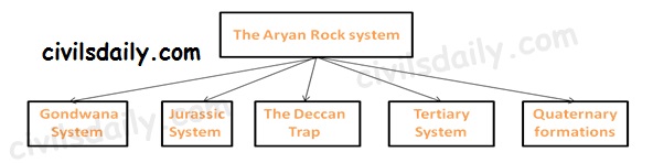
Based on this complex and varied geological history, the Geological Survey of India has classified rock systems of the country into 4 major divisions:
Classification of the Indian Rock Systems by the Geological Survey of India
Let us study the basic features of each of these:
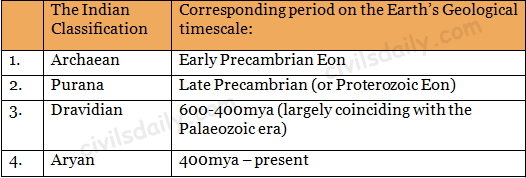
The Pre-Cambrian Rocks – The Archaean and the Purana Rock System
The Archaean rock system (Early Pre-Cambrian)
The Archaean group of rocks consists of two systems-(a) Achaean granites and gneisses, and (b) Dharwarian sedimentary:
Archaean Gneisses and Schists (pre 2500 million years)
The Archean System contains the first formed rocks of the earth.
The rocks are primarily gneisses and granites, having no marks of fossils.
They often underlie the strata formed subsequently and the system is generally known as the basement complex or fundamental gneisses.
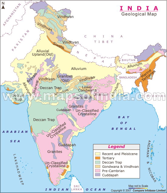
The Archaean rocks cover two-thirds of the peninsular India. They also occur in roots of the mountain peaks all along the Greater Himalayas, trans-Himalayan ranges of Zaskar, Ladakh and Karakoram.
Dharwar System (2500-1800 million years ago)
The weathering of the Archaean rocks yielded the earliest sediments and formed the oldest sedimentary strata, the Dharwar system.
These are found today in metamorphic forms and do not contain fossils.
These rocks occur in scattered patches in parts of Karnataka, Tamil Nadu, central and eastern parts of Chotanagpur plateau, Meghalaya plateau, Aravalis, Himalayan region etc as shown on the map.
The Archaean rocks are economically the most important rocks because they possess valuable minerals like high-grade iron ore, manganese, copper, lead, gold, quartzite, slates, mica, etc.
1. The Purana Rock System (Late Pre-cambrian):
The Archaean gneiss and the Dharwar rocks underwent further erosion leading to the formation of the Purana Rock system.
The Purana rock system is further subdivided into (i) the Cuddapah and (ii) the Vindhyan
The Cuddapah
These rocks are generally without fossils
These formations, named after the Cuddapah district in Andhra Pradesh are sedimentary metamorphic formations.
These are found in Andhra Pradesh, southern Chhattisgarh, Odisha and along the main axis of Aravallis.
The metallic content in ores of Cuddapah rocks is low and at places uneconomical for extraction.
The Vindhyan
This system derives its name from the Vindhyan mountains
Consists of enormous sedimentary deposits. In some tracts, Vindhyan rocks are buried under the Deccan lava.
It stretches from Sasaram in Bihar to Chittorgarh in Rajasthan with the exception of the central tract of Bundelkhand gneiss.
The well-known diamond mines of Panna and Golconda lie in the Vindhayan region.
This rock system is well known for red sandstone, sandstone, durable stones, ornamental stones, raw materials for lime, glass, cement and chemical industries.
2. The Dravidian Rock system (Cambrian to middle carboniferous)
These formations do not occur in the peninsular plateau as it was above the sea level at that time but are found in continuous sequence in the Himalayas.
They contain abundant fossils in them
Coal formation started in the Carboniferous age. Carboniferous in geology means coal-bearing. [Most of the coal found in India is not of the Carboniferous period; High-quality coal of Great Lakes Region-USA, U.K and Ruhr region is Carboniferous coal].
3. The Aryan Rock system (Upper Carboniferous to recent)
The Aryan Rock System
The Gondwana System:
The peninsula during the Upper Carboniferous period experienced crustal movements, which led to the formation of basin-shaped depressions. These depressions had countless terrestrial plants and animals, which were buried to from coal deposits in India known as the Gondwana Rocks.
These rocks have also marks of climatic changes from arctic cold to tropical and desert conditions.
These Rocks are found mainly in the Damodar, the Mahanadi and the Godavari valleys of the peninsula.
Gondwana rocks contain nearly 98 percent of India’s coal reserves. Gondwana coal is much younger than the Carboniferous coal and hence its carbon content is low.
Jurassic System:
The marine transgression in the latter part of the Jurassic gave rise to thick series of shallow water deposits in Rajasthan and in Kuchchh.
Coral limestone, sandstone, conglomerates and shales occur in Kuchchh.
Another transgression on the east coast of the Peninsula is found between Guntur and Rajahmundry.
The Deccan Trap:
Towards the end of the Mesozoic era, intensive volcanic activity took place, which flooded with lava vast areas of Maharashtra and other parts of the Deccan known as the Deccan traps.
The volcanic rocks contain some thin fossiliferous sedimentary layers found between the lava flows. This indicates that the lava flows was not continuous. The volcanic activity led to two great events
1. Breakup of the Gondwanaland masses
2. Uplift of the Himalayas out of the Tethys Sea.
Present Deccan Trap covers about 5 lakh sq km mainly in parts of Kuchchh, Saurashtra, Maharashtra, the Malwa plateau and northern Karnataka.
The weathering of these rocks for a long time has given birth to black cotton soil known as ‘regur’.
Tertiary System
Eocene to Pliocene about 60 to 7 million years ago.
The tertiary is the most significant period in India’s geological history because the Himalayas were born and India’s present form came into being in this period.
The Pleistocene and recent formations (The quaternary period)
Quaternary is the name proposed for very recent deposits, which contains fossils of species with living representatives
These include Satluj-Ganga-Brahmaputra plains and Karewa formations of the Kashmir valley.
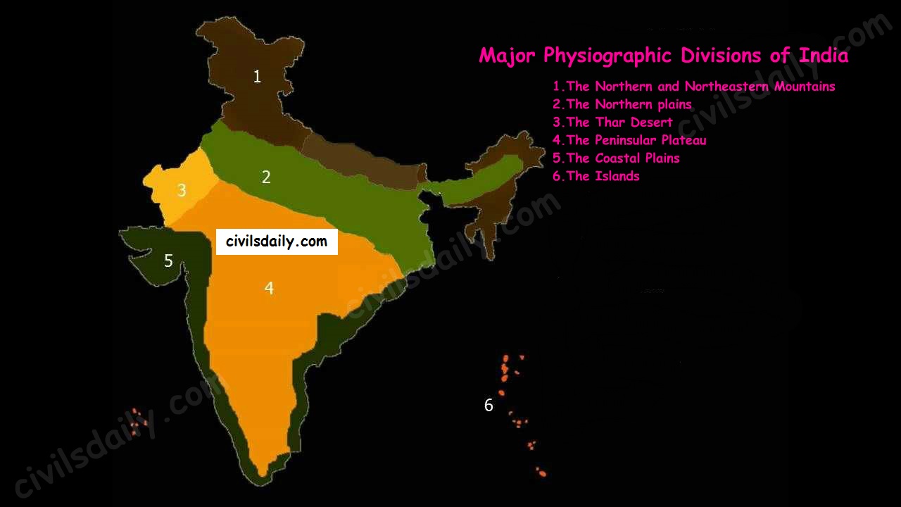
Geological Divisions of India:
Geologic divisions are marked by geologists as regions of similar rocks, structures and geologic history [Recall the brief geological history of India discussed above]. Geologically, India is divided into 3 major regions (also called the Triple Tectonic division):
The Peninsular Plateau region – It also includes the Shillong Plateau and the Kutchch Kathiawar region (Outliers)
The Extra-peninsular region – the mountainous region of Himalayas.
The Himalayas are young, weak and flexible in their geological structure, unlike the rigid and stable Peninsular Block.
Consequently, they are still subjected to the interplay of exogenic and endogenic forces, resulting in the development of faults, folds and thrust plains.
These mountains are tectonic in origin, dissected by fast-flowing rivers which are in their youthful stage.
Various landforms like gorges, V-shaped valleys, rapids, waterfalls, etc. are indicative of this stage.
The Indo-Gangetic Plain between the above two.
In addition to these, there are 2 minor divisions:
The Coastal Plains (Eastern and western)
The Islands (Lakshadweep and Andaman and Nicobar)
Physiographic divisions of India
Physiography deals with the study of surface features. This includes the landforms (mountains and valleys, their shape and steepness), the way rivers flow across the land, and the way in which the land erodes. Geographers recognize physiographic divisions based on the shape of the land.
There is a close relationship between India’s physiographic and geologic divisions as geology affects the way the land erodes.
The Indian landmass can be divided into the following broad physiographic units:
The Northern and Northeastern Mountains
The Northern plains
The Thar Desert
The Peninsular Plateau
The Coastal Plains
The Islands
The Major Physiographic Divisions of India
In the next articles, we will study each of these divisions in detail. [For the next article on the Himalayan mountains, click here]
But before we proceed to the next article, let’s look at the following question from a past UPSC examination:
Prelims:
1997:
Question: Match List I with List II and select the correct answer using the codes given below the lists:
The European Union (EU) is a political and economic union of 28 member states that are located primarily in Europe
The Maastricht Treaty established the European Union in 1993 and introduced European citizenship
The EU has developed an internal single market through a standardized system of laws that apply in all member states
EU policies aim to ensure the free movement of people, goods, services, and capital within the internal market, enact legislation in justice and home affairs, and maintain common policies on trade, agriculture, fisheries, and regional development
Within the Schengen Area, passport controls have been abolished
The EU traces its origins from the European Coal and Steel Community (ECSC) and the European Economic Community (EEC), established, respectively, by the 1951 Treaty of Paris and 1957 Treaty of Rome
National Company Law Appellate Tribunal (NCLAT) was constituted under Section 410 of the Companies Act, 2013 for hearing appeals against the orders of National Company Law Tribunal(s) (NCLT), with effect from 1st June 2016
NCLAT is also the Appellate Tribunal for hearing appeals against the orders passed by Insolvency and Bankruptcy Board of India under Section 202 and Section 211 of IBC
NCLAT is also the Appellate Tribunal to hear and dispose of appeals against any direction issued or decision made or order passed by the Competition Commission of India (CCI)
The President of the Tribunal and the chairperson and Judicial Members of the Appellate Tribunal shall be appointed after consultation with the Chief Justice of India
The Members of the Tribunal and the Technical Members of the Appellate Tribunal shall be appointed on the recommendation of a Selection Committee consisting of—
(a) Chief Justice of India or his nominee—Chairperson;
(b) a senior Judge of the Supreme Court or a Chief Justice of High Court— Member;
(c) Secretary in the Ministry of Corporate Affairs—Member;
(d) Secretary in the Ministry of Law and Justice—Member; and
(e) Secretary in the Department of Financial Services in the Ministry of Finance— Member
Solar radiation management (SRM or solar geoengineering) is a theoretical approach to reducing some of the impacts of climate change by reflecting a small amount of inbound sunlight back out into space
It is in the early stages of research
SRM would not directly reduce concentrations greenhouse gases
Different SRM techniques have been proposed such as- Stratospheric aerosol injection, Marine cloud brightening
Stratospheric aerosols might delay the regeneration of the ozone layer
Link for the test: Click2Attempt (Let us know your score in comments)
We have started our Open SIP program in conjunction with our PAID program (Click2Know all details of the program)
We will be running this special FREE initiative on daily basis providing students with revision questions for static subjects as well as current affairs starting from June 2017
Test 8 as per schedule (Click2View) is CA August’17
Liked the test? You can join our FLT program containing more such high-level questions. The module contains 11 FLTs (8 paper 1 TS + 3 CSAT)
Know all details about the program and join here: Click2Join
Want to do quick revision for Prelims? Join our SIP Comprehensive or SIP Mini modules giving you Static & Dynamic subjects coverage through video lectures
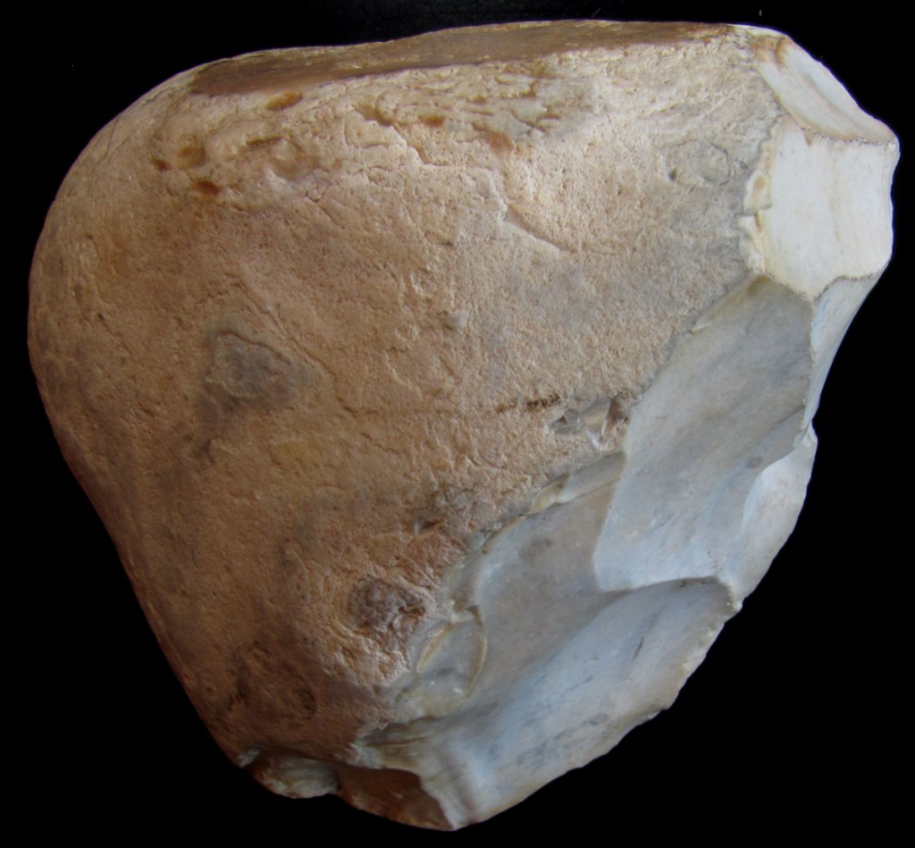
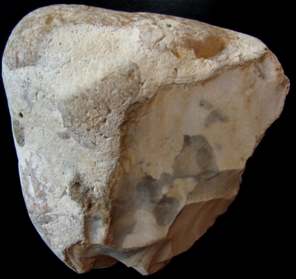
This topic is not one of UPSC’s favorites and too much details and depth is not required. You need to make a note of 2 things. First, try to understand the evolution of tool technology, memorize which technology(flint, flakes, microliths) corresponds to which age. Second, refer the table at the end. Memorize what started in which age.
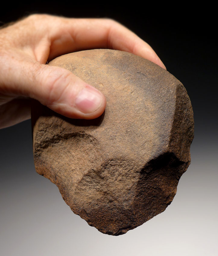
Paleolithic Age – It is the longest phase divided in to 3 phases.
1) Early (lower) – 500K -50K BC
2) Middle – 50K – 40K BC
3) Late (upper) – 40K – 10K BC
Followed by the Mesolithic Age(9K to 4K BC) which is regarded as a transitory phase and then Neolithic Age. Neolithic Age began at different times in different parts of the country. But generally Neolithic settlements found in India are no older than 2500 BC.
EVOLUTION OF TOOL TECHNOLOGY
Tools were made by keeping one stone fixed and striking it with another stone. If the tools were made out of the larger leftover ‘core’, they were called core tools. If made using the smaller piece of stone ‘flaked’ out, they were called flake tools.
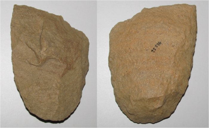
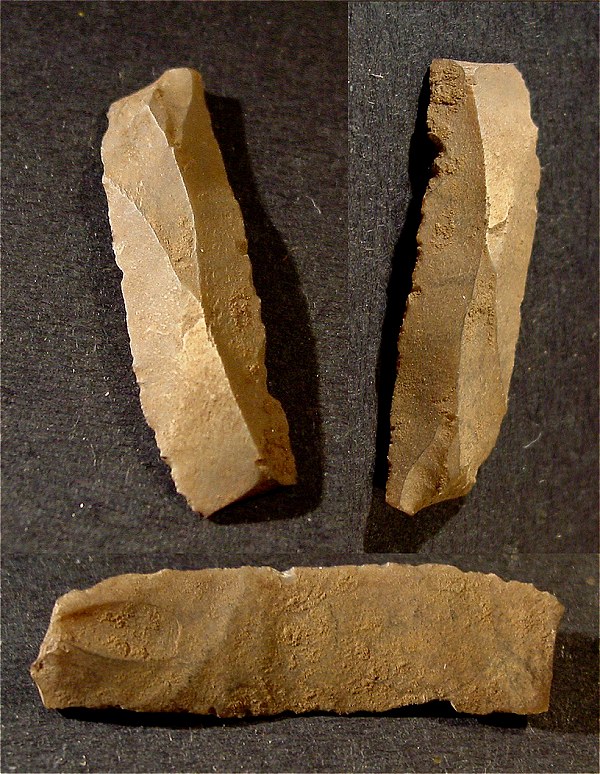
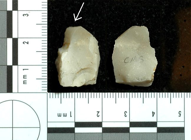
EARLY PALEOLITHIC AGE – Made of core part.
1. Chopper: using a bowl shaped piece of stone, a heavy and bold tool was created. Only one side was worked on (unifascial).
2. Chopping tool: same as the chopper but with 2 edges worked on (bifascial). Chopper and chopping tool are characteristic of lower palaeolithic.
3. Hand axe: A tool requiring much greater control than the chopper, a narrower tool with vertical working edge.
4. Cleaver: cleavers are different from hand-axes in having a transverse or horizontal working edge.
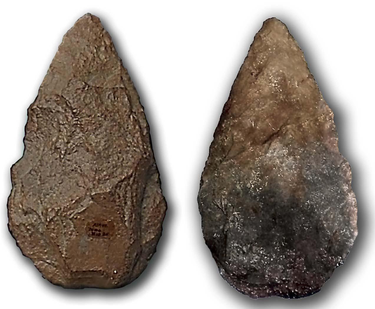
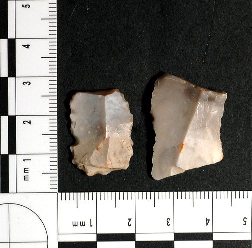
MIDDLE PALEOLITHIC AGE – Flake tools. They are lighter, more precise.
1. Blades: Parallel working edges.
2. Scraper: parallel working edges on the sides, similar to blade, with the difference being blades are much longer than they are wide. This is also a flake tool.
3. Points: sharpened up to a tip: like a point. 2 sideways working edges meet up to the tip. These are sometimes grafted onto a wooden handle, for which a shoulder is present.
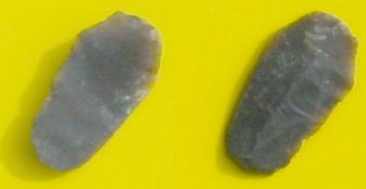
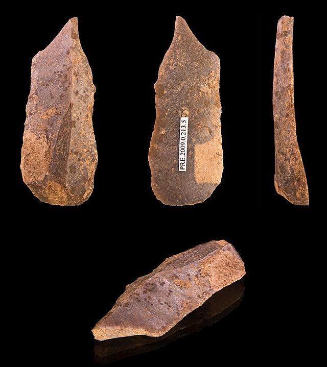
UPPER PALEOLITHIC – Flint Tools
1. Burins: unlike a point, the tip is flat like the end of a screwdriver.
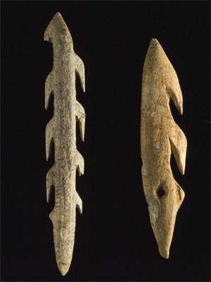
2. Bone tools: Eg. harpoon: used for fishing as fishing hooks. May be one sided or two sided.
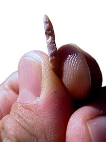
MESOLITHIC AGE
In this age, we get Microliths. These are very small tools (1cm to 8cm) often geometrical in shape, these were used for beautification (eg) tattooing, shaving etc.
Sometimes they were grafted onto wooden shafts: called composite tools.
Names were according to the shape of the tool: trapezoid, lunate, microlith points, microlith blades etc.
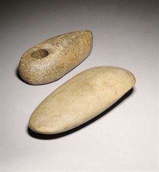
NEOLITHIC AGE – Polished Tools
We see remarkable Polished tools. Rounded heavy tools discovered, which could have been possibly used to level the ground. May have the provision for a handle as well.
1. Celt: used for digging the ground, like an edge.
MAIN CHARACTERISTICS
Early (lower) – 500K -50K
Middle – 50K – 40K
Late (upper) – 40K – 10K
Mesolithic (9K to 4K)
Neolithic
Technology
Flakes
Flints
Microliths
Polished Tools.
Stone Used
Quartzite
Quartzite
Chert, Jasper
Agate
Dyke, Basalt, Dolomite.
Occupation
Hunting, food gathering and fishing.
Hunting, food gathering and fishing
Hunting, food gathering and fishing.
Homo-sapiens come in.
Hunting, food gathering and fishing.
In the later phase they start domesticating animals.
Hunting, food gathering and fishing came to an end.
Regular agriculture begins. Settled in smaller villages
Food producing age.
Mehrgarg – wheat, cotton
Mirzapur – cultivation of rice.
Sites
Soan or Sohan Valley, Punjab
Belan Valley , Mirzapur District, UP (near Allahabad)
Didwana, Rajasthan
Bhimbetka, MP
Geography coincides roughly with the Lower Paleolithic sites.
Upper levels of Gujrat Dunes.
Andhra, Karnataka, Maharashtra, Central MP, south UP.
Bhimbetka caves used as shelters.
Adamgargh, MP & Bagor, Rajasthan – earliest evidence of domestication of animals.
Salt Lake, Sambhar deposits suggest cultivation of plants.
North
Kashmiri – dwelling pits, range of ceramics, variety of stone and bone tools and absence of microlith. Burzahom, Gufkrul
Bihar – Chirand
South
South of Godavari
East
Assam, Garo Hills
Burial
No burial found
Burzahom – Domestic dogs buried with their masters.
Pottery
No pottery found
First reference of pottery.
Burzahom – coarse grey pottery.
Hand-made pottery found in this age. Later period – footwheel is also used.
Included black-burnished ware, greyware and mat-pressed ware.
Painting
Bimbetka in Madhya Pradesh, Belan Valley in Uttar Pradesh and Narmada Valley have prehistoric art belonging to all the 3 phases.
Objectives/need for amendment:Give autonomy to IIM’s
Key features of the bill
Allow IIMs to grant degrees to their students.
Grant complete autonomy to IIMs, combined with adequate accountability.
Coordination Forum of IIMs as an advisory body will be established. Board of an IIM will drive the management of the institution. It will select Chairperson and Director of IIM. Board will have greater participation of experts and alumni. It will also include women and members from Scheduled Castes/Tribes.
Periodic review of the performance of IIM will be conducted by independent agencies and their results will be placed in public domain. The Annual Report of the IIMs will be placed in the Parliament and CAG (Comptroller and auditor general of India) will audit their accounts.
Paramparagat Krishi Vikas Yojana is an elaborated component of Soil Health Management (SHM) of major project National Mission of Sustainable Agriculture (NMSA)
Under PKVY Organic farming is promoted through the adoption of the organic village by cluster approach and PGS certification
Groups of farmers would be motivated to take up organic farming under Paramparagat Krishi Vikas Yojana (PKVY)
Fifty or more farmers will form a cluster having 50-acre land to take up the organic farming under the scheme
The produce will be pesticide residue free and will contribute to improving the health of the consumer
Brief Intro: The M777 howitzer is a towed 155 mm artillery piece. It succeeded the M198 howitzer in the United States Marine Corps and United States Army in 2005
The M777 is also used by the ground forces of Australia, Canada, India and Saudi Arabia. It made its combat debut in the War in Afghanistan
The M777 is manufactured by BAE Systems’ Global Combat Systems division