💥Join UPSC 2027,2028 Mentorship (July Batch) + XFactor Notes & Microthemes PDF

Subject: Conservation & Mitigation

1. Conservation Progs.
2. Worldwide initiatives
3. Mitigation Strategies
4. Conventions and Protocols

  • Loggerhead Turtles use Geomagnetic Field to navigate large Distances

    Loggerhead Turtles use Geomagnetic Field to navigate large Distances

    Why in the News?

    A new study in Nature reveals that loggerhead turtles can learn and remember the magnetic signature of an area, using Earth’s geomagnetic field for navigation during long migrations.

    About Loggerhead Sea Turtles (Caretta caretta)

    • Loggerhead Sea Turtles belong to the Cheloniidae family, widely distributed across the world’s oceans.
    • They are commonly found in Atlantic, Pacific, Indian Oceans, and the Mediterranean Sea.
    • They Spends most of its life in saltwater and estuarine habitats, coming ashore only to nest.
    • They are omnivorous, feeding primarily on bottom-dwelling invertebrates.
    • It is listed as Vulnerable by the International Union for Conservation of Nature (IUCN).
    • International trade banned under CITES Appendix I.

    Significance of the study

    • Loggerhead turtles travel thousands of kilometers across oceans and return to the same feeding and nesting sites.
    • Their ability to store magnetic memories helps them navigate vast distances, reinforcing the hypothesis that other migratory species may also rely on Earth’s magnetic field.

    PYQ:

    [2019] Consider the following statements:

    1. Some species of turtles are herbivores.
    2. Some species of fish are herbivores.
    3. Some species of marine mammals are herbivores.
    4. Some species of snakes are viviparous.

    Which of the statements given above are correct?

    (a) 1 and 3 only
    (b) 2, 3 and 4 only
    (c) 2 and 4 only
    (d) 1, 2, 3 and 4


  • Sṛjanam- India’s first indigenous Automated Bio Medical Waste Treatment Plant

    Why in the News?

    Union Ministry of Science & Technology has launched India’s first indigenous Automated Biomedical Waste Treatment Plant, named “Sṛjanam,” at AIIMS, New Delhi.

    About Sṛjanam

    • Sṛjanam is India’s first indigenously developed Automated Biomedical Waste Treatment Rig, designed by CSIR-NIIST, Thiruvananthapuram.
    • It provides a sustainable, non-incineration-based solution for biomedical waste disposal, aligning with India’s Waste to Wealth vision.
    • Key Features:
      • Eco-Friendly & Non-Incineration-Based: Eliminates the need for incineration, reducing toxic emissions.
      • High-Efficiency Pathogen Elimination: Disinfects blood, urine, sputum, and lab disposables, with third-party validated antimicrobial action.
      • Safe & Fully Automated: Minimizes human exposure, reducing the risk of infections and spills.
      • Capacity & Scalability: Processes 400 kg of biomedical waste daily, with 10 kg/day degradable waste capacity in phase one.
      • Odor Neutralization: Eliminates foul smells, ensuring safer surroundings.
      • Supports Circular Economy: Enhances waste segregation and recyclability, reducing landfill burden.

    PYQ:

    [2019] In India, ‘extended producer responsibility’ was introduced as an important feature in which of the following?

    (a) The Bio-medical Waste (Management and Handling) Rules, 1998

    (b) The Recycled Plastic (Manufacturing and Usage) Rules, 1999

    (c) The e-Waste (Management and Handling) Rules, 2011

    (d) The Food Safety and Standard Regulations, 2011


  • Brahmagiri Wildlife Sanctuary

    Why in the News?

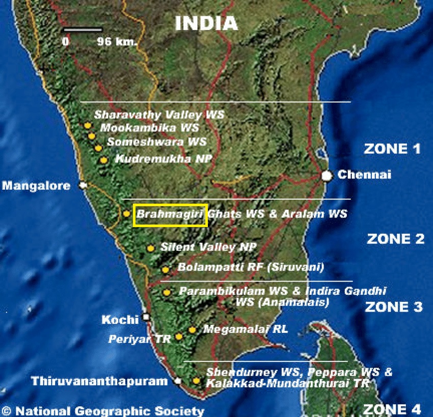
    The Karnataka government’s move to build a tribal village in Brahmagiri Wildlife Sanctuary’s buffer zone has sparked debates on environmental conservation, tribal rights, and human-wildlife conflict.

    Brahmagiri Wildlife Sanctuary

    About Brahmagiri Wildlife Sanctuary:

    • The Brahmagiri WLS is located in Kodagu District, Karnataka, within the Western Ghats.
    • It serves as a crucial ecological corridor, facilitating wildlife movement between Nagarhole National Park and Wayanad Wildlife Sanctuary.
    • Geographical Location and Features
      • It is situated approximately 250 km from Bengaluru and derives its name from the Brahmagiri Peak, the highest point in the region.
      • The sanctuary was declared a protected area on June 5, 1974, to conserve its unique flora and fauna.
      • The terrain consists of evergreen and semi-evergreen forests, grasslands, and shola forests, which provide a habitat for various species.
    • Flora:
      • Bamboo species are widely spread across the region, providing food for herbivores like elephants and deer.
      • The diverse vegetation supports a wide range of faunal species by offering food, shelter, and nesting sites.
    • Fauna:
      • Carnivores: Tigers, jungle cats, leopard cats, wild dogs, and sloth bears.
      • Herbivores: Indian elephants, gaurs, sambars, spotted deer, barking deer, mouse deer, and wild pigs.
      • Primates: Lion-tailed macaques, Nilgiri langurs, slender loris, bonnet macaques, and common langurs.
      • Small Mammals & Rodents: Malabar giant squirrels, giant flying squirrels, Nilgiri martens, common otters, brown mongooses, civets, porcupines, and pangolins.
      • Reptiles: King cobras, Indian cobras, pythons, Malabar pit vipers.
      • Birds: Emerald doves, square-tailed bulbuls, and Malabar trogons.

    PYQ:

    [2020] Which one of the following protected areas is well-known for the conservation of a sub-species of the Indian swamp deer (Barasingha) that thrives well on hard ground and is exclusively graminivorous?

    (a) Kanha National Park

    (b) Manas National Park

    (c) Mudumalai Wildlife Sanctuary

    (d) Tal Chhapar Wildlife Sanctuary


  • [7th February 2025] The Hindu Op-ed: The saga of regulating India’s thermal power emissions

    PYQ Relevance:

    Q) Describe the benefits of deriving electric energy from sunlight in contrast to the conventional energy generation. What are the initiatives offered by our government for this purpose? (UPSC CSE 2020)


    Mentor’s Comment: UPSC mains have always focused on Environmental Impact Assessment studies (2015), and conventional energy generation (2020).

    On December 30, 2024, the MoEFCC extended the deadline for thermal plants to meet SO₂ emission norms by three years without explanation. Originally set for December 31, 2024, this delay affects 20 GW of plants near densely populated areas. These norms were set in 2015 to tighten particulate matter limits and introduced SO₂ norms for the first time, aligning them with standards in countries like Australia, China, and the U.S., despite the short timeline for compliance.

    Today’s editorial talks about the revised emission norms for Indian thermal plants and impact of these norms. This content will help in GS Paper 3.

    _

    Let’s learn!

    Why in the News?

    On December 30, 2024, India’s Ministry of Environment, Forest and Climate Change (MoEFCC) changed the Environment Protection Rules, extending the deadline for thermal power plants to meet sulphur dioxide (SO₂) emission standards by three years without providing any explanation.

    What are the revised emission norms for Indian thermal plants?

    • New Deadlines: On December 30, 2024, India’s Ministry of Environment, Forest and Climate Change (MoEFCC) extended the deadlines for thermal power plants to comply with sulphur dioxide (SO₂) emission norms by three years. The revised deadlines are:
      • Category A (By Dec 31, 2027) – Thermal plants within 10 km of NCR or cities with over 1 million population (e.g., Dadri NTPC, Koradi) must comply first due to high pollution and population density.
      • Category B (By Dec 31, 2028) – Plants in critically polluted areas or non-attainment cities (e.g., Singrauli, Korba, Chandrapur) get extended timelines due to severe environmental concerns.
      • Category C (By Dec 31, 2029) – All other plants (e.g., Talcher, Mundra, Simhadri) must comply last as they are in lower-risk areas with relatively better air quality.
    • Historical Context: The original norms were established in December 2015, with an initial compliance deadline set for December 2017. This was later extended multiple times due to various challenges.

    Note: The categories for compliance with SO₂ emission norms for Indian thermal power plants are based on location and environmental impact.

    What are the challenges around implementing the flue gas desulphurisation (FGD) technology?

    • Technical and Financial Hurdles: The implementation of FGD technology has faced delays primarily due to high costs, inadequate supply chains, and operational complexities. Many plants tendered contracts for FGDs but did not progress at a pace necessary to meet earlier deadlines.
    • Debate on Necessity: Recent studies commissioned by NITI Aayog and conducted by CSIR-NEERI have questioned the urgency and necessity of FGD installations for improving air quality, suggesting that focus should instead be on particulate emissions. This has led to confusion and varied interpretations of compliance requirements among stakeholders.

    How successful has India been in implementing emission norms for thermal power plants?

    • Limited Progress: As of late 2024, only about 22 GW of thermal capacity had installed FGDs, which is less than 8% of the total coal-fired power generation capacity in India. The overall progress has been slower than anticipated since the introduction of the norms.
    • Compliance Monitoring Issues: There is a lack of transparency regarding adherence to existing norms, as pollution control boards have not consistently verified compliance. This raises concerns about the effectiveness of regulatory oversight.

    What are the economic and environmental consequences of noncompliance and what measures are in place to address this?

    • Health Impacts: The extension of compliance deadlines poses risks to public health, especially in densely populated areas like Delhi-NCR, where air pollution is already a critical issue. SO₂ is known to contribute to respiratory and cardiovascular diseases.
    • Financial Burden on Consumers: Electricity regulators have allowed thermal plants to pass on the costs of installing FGDs to consumers, regardless of whether emission norms are met. This means consumers may end up paying for pollution control equipment that remains unused due to extended compliance timelines.
    • Environmental Compensation: For non-compliance beyond specified timelines, MoEFCC has introduced an environmental compensation scheme that penalizes plants based on their duration of non-compliance. This includes fees that escalate over time but may not be sufficient to incentivize timely compliance.

    Way forward: 

    • Strict Enforcement & Incentives – Strengthen regulatory oversight with real-time emissions monitoring, enforce penalties for non-compliance, and provide financial incentives or subsidies to accelerate FGD adoption.
    • Balanced Policy Approach – Address technical and financial barriers by improving supply chains, supporting domestic FGD manufacturing, and ensuring a phased yet firm transition while prioritising high-risk areas.
  • What is the SC directive on sacred groves?

    Why in the News?

    On December 18, 2024, the Supreme Court ordered Rajasthan’s Forest Department to map all sacred groves using satellite and ground surveys based on their cultural and ecological importance, regardless of their size.

    Note: In Rajasthan, sacred groves, locally known as ‘orans’, are estimated to number around 25,000, covering approximately 6 lakh hectares across the state.

    What are the implications of the December 18 order? 

    • Conflict with the Forest Rights Act (FRA), 2006 – The order contradicts the FRA, which was enacted to recognize and vest forest rights with gram sabhas. Instead, the decision shifts control from communities to the Forest Department.
    • Loss of Community Autonomy – Sacred groves, which have been traditionally protected by local communities, will now be governed by state authorities, potentially disrupting cultural conservation practices.
    • Potential Erosion of Traditional Governance Systems – The transfer of management could weaken customary laws and traditional conservation practices that have preserved these groves for generations.
    • Legal Precedence for Future Cases – By prioritizing the Wildlife Protection Act (WLPA), 1972, over the FRA, this order may set a precedent for other community-managed lands to be taken over by the Forest Department.
    • Impact on Livelihoods and Religious Practices – Communities that depend on sacred groves for religious, medicinal, and cultural purposes may face restrictions under the new classification as ‘community reserves’.

    What did T.N. Godavarman v. Union of India establish about the definition of ‘forest land’? 

    • Broad Definition: The Supreme Court established that ‘forest land’ includes not only areas understood as forests in the dictionary sense but also any area recorded as forest in government records, regardless of ownership.
    • Expert Committees: The ruling directed state governments to form expert committees to identify areas that fit this definition of ‘forest land’.

    How are sacred groves traditionally conserved by communities?

    • Watershed & Ecological Functions: Many sacred groves protect natural water sources, prevent soil erosion, and regulate local climate. Example: Orans (Rajasthan) – These groves support perennial water streams and serve as critical grazing lands for livestock.
    • Strict Protection through Customary Laws & Taboos: Communities impose strict prohibitions on tree felling, hunting, or resource extraction in sacred groves. Example: Sarpa Kavu (Kerala) – These groves are dedicated to serpent deities, and cutting trees is considered a bad omen.
    • Religious & Cultural Practices for Conservation: Rituals, festivals, and community prayers reinforce the spiritual importance of these groves. Example: Devara Kadu (Karnataka) – Annual worship ceremonies maintain local participation in conservation efforts.
    • Community Governance & Management: Local elders, priests, or village councils oversee the maintenance and enforcement of protection norms. Example: Jahera (Odisha, Chhattisgarh) – Tribal communities like the Gonds and Santhals manage these groves as sacred spaces.
    • Role in Biodiversity Preservation: The groves act as biodiversity hotspots, protecting endemic flora, fauna, and medicinal plants. Example: Law Kyntang (Meghalaya) – Khasi communities conserve these forests, which shelter rare orchids and medicinal herbs.

    Way forward:

    • Harmonizing Legal Frameworks – Amend policies to ensure the Forest Rights Act (FRA), 2006, and Wildlife Protection Act (WLPA), 1972, work in tandem, recognizing gram sabhas’ authority in managing sacred groves while ensuring ecological conservation.
    • Community-Centric Conservation – Strengthen traditional governance systems by legally empowering local communities to manage sacred groves, integrating scientific conservation methods with cultural practices.

    Mains PYQ:

    Q Examine the status of forest resources in India and its resultant impact on climate change. (UPSC IAS/2020)

  • Ocean Coordination Mechanism (OCM)

    Why in the News?

    The Ocean Coordination Mechanism (OCM) was recently announced by the Intergovernmental Oceanographic Commission (IOC) of UNESCO on January 14, 2025.

    What is Ocean Coordination Mechanism (OCM)?

    • The OCM, launched by the Intergovernmental Oceanographic Commission (IOC) of UNESCO, aims to enhance marine conservation and resource management.
    • It focuses on the Caribbean and North Brazil Shelf, regions with rich biodiversity, coral reefs, and fisheries generating $610 million annually.
    • The OCM promotes Blue Carbon Projects, using coastal ecosystems for carbon storage, benefiting both climate resilience and local communities.
    • It has secured $15 million in funding from the Global Environment Facility (GEF) under the UNDP/GEF PROCARIBE+ Project, with an additional $126.02 million in co-financing.

    Intergovernmental Oceanographic Commission (IOC) of UNESCO

    • Established in 1961, the IOC/UNESCO promotes marine science cooperation for sustainable ocean governance.
    • It operates in key areas:
      • Ocean science research:  Supports studies on climate change, biodiversity, and sustainability.
      • Tsunami warning systems:  Maintains early warning mechanisms to mitigate risks.
      • Ocean observations:  Collects and analyzes oceanographic data for policy-making.
    • The IOC leads the UN Decade of Ocean Science for Sustainable Development (2021-2030), known as the “Ocean Decade”, advancing global marine conservation efforts.


    Ocean Coordination Mechanism (OCM)

    About the Caribbean Sea

    • The Caribbean Sea is part of the North Atlantic Ocean, located south of the Gulf of Mexico and southwest of the Sargasso Sea.
    • Bordering Nations:
      • Greater Antilles – Cuba, Jamaica, Hispaniola (Haiti & Dominican Republic), Puerto Rico.
      • Lesser Antilles – Includes islands from Virgin Islands to Trinidad & Tobago.
      • South America – Borders Venezuela & Colombia.
      • Central America – Includes Panama, Costa Rica, Nicaragua, Honduras, Guatemala, Belize.
    • Key Features:
      • Deepest Point – The Cayman Trough, at 7,686 meters below sea level.
      • Mesoamerican Barrier ReefSecond-largest barrier reef globally, stretching 1,000 km.
      • Major Gulfs and Bays – Includes Gulf of Venezuela, Gulf of Honduras, and Gulf of Darién.
    • The Caribbean Sea supports rich biodiversity but faces threats from climate change, pollution, and overfishing, making conservation efforts like OCM essential for sustainability.

    PYQ:

    [2021] Consider the following statements :​

    1. The Global Ocean Commission grants licences for seabed exploration and mining in international waters.​

    2. India has received licences for seabed mineral exploration in international waters.​

    3. ‘Rare earth minerals’ are present on seafloor in international waters.​

    Which of the statements given above are correct?

    (a) 1 and 2 only ​

    (b) 2 and 3 only​

    (c) 1 and 3 only ​

    (d) 1, 2 and 3​

  • Centre clears exploratory drilling in Hollongapar Gibbon Sanctuary

    Why in the News?

    Exploratory drilling for oil and gas has been approved within the eco-sensitive zone surrounding the Hollongapar Gibbon Wildlife Sanctuary.

    About the Hollongapar Gibbon WLS

    • Hollongapar Gibbon Wildlife Sanctuary was initially established as Hollongapar Reserve Forest in 1997 and renamed in 2004.
    • It is the only habitat for hollock gibbons in India.
    • Located in Assam, with the Bhogdoi River along its northern boundary.
    • Biome classified as plains alluvial semi-evergreen forests with patches of wet evergreen forests.
    • Flora:
      • Upper canopy: Dominated by Hollong trees (Dipterocarpus macrocarpus), Sam, Amari, Sopas, Bhelu, Udal, and Hingori.
      • Middle canopy: Features Nahar trees.
      • Lower canopy: Composed of evergreen shrubs and herbs.
    • Fauna:
      • Primates: Includes Hoolock Gibbons, Bengal Slow Loris (only nocturnal primate in Northeast India), stump-tailed macaques, northern pig-tailed macaques, eastern Assamese macaques, rhesus macaques, and capped langurs.
      • Other mammals: Indian elephants, tigers, leopards, jungle cats, wild boars, civets, squirrels, and more.

    About the Hoolock Gibbons:

    • Gibbons are the smallest and fastest apes, and they inhabit tropical and subtropical forests across Southeast Asia.
    • It is the only ape specie found in India.
    • They possess high intelligence, exhibit distinct personalities, and have strong familial bonds, reflecting characteristics similar to other ape species.
    • The current population of hoolock gibbons is estimated at around 12,000, found primarily in Northeast India, Bangladesh, Myanmar, and southern China.
    • Two distinct species, the eastern hoolock gibbon (Hoolock leuconedys) and the western hoolock gibbon (Hoolock hoolock), were previously reported in India.
    • Conservation Status
      • IUCN Red List: the western hoolock gibbon is classified as Endangered, and the eastern hoolock gibbon is classified as Vulnerable.
      • Both gibbon species in India are placed under Schedule I of the Wildlife (Protection) Act, 1972.


    PYQ:

    [2010] Consider the following pairs:

    Protected Area:: Well-known for

    1. Bhitarkanika, Orissa :: Salt Water Crocodile

    2. Desert National Park, Rajasthan :: Great Indian Bustard

    3. Eravikulam, Kerala :: Hoolock Gibbon

    Which of the pairs given above is/are correctly matched?

    (a) 1 only

    (b) 1 and 2 only

    (c) 2 only

    (d) 1, 2 and 3

  • NGT issues notice to Centre on use of invasive fish species for mosquito control

    Why in the News?

    The National Green Tribunal (NGT) has sought a response from the Central government regarding the use of two highly invasive and alien fish speciesGambusia affinis (Mosquitofish) and Poecilia reticulata (Guppy)—as biological agents for mosquito control in multiple states.

    Both species are classified as “invasive and alien” by the National Biodiversity Authority (NBA).

    About Gambusia Affinis (Western Mosquitofish)

    • It has been widely introduced worldwide as a biological control agent to reduce mosquito populations.
    • The mosquitofish primarily feeds on mosquito larvae, small insects, and zooplankton.
    • Despite its intended benefits, Gambusia affinis has been identified as one of the world’s most invasive species.
    • It is highly aggressive and competes with native fish for resources.
    • It also preys on the eggs and juveniles of indigenous fish, amphibians, and invertebrates, leading to a decline in local biodiversity.
    • The Invasive Species Specialist Group (ISSG) has listed it among the 100 worst invasive species globally due to its harmful ecological impact.

    About Poecilia Reticulata (Guppy, Millionfish, Rainbow Fish)

    • Poecilia reticulata, commonly known as the Guppy, Millionfish, or Rainbow Fish, is a small freshwater fish native to Northern South America and the Caribbean.
    • It is widely recognized for its vibrant colors and adaptability, making it a popular choice for both aquarium enthusiasts and mosquito control programs worldwide.
    • It is a highly adaptable species, capable of surviving in a variety of freshwater environments.
    • Guppies are omnivorous, feeding on mosquito larvae, small insects, algae, and organic detritus.
    • Their feeding habits make them a common choice for mosquito control programs, although their effectiveness is still debated.
    • While guppies are less aggressive than mosquitofish, their population growth can still disrupt local ecosystems.

    PYQ:

    [2023] ‘Wolbachia method’ is sometimes talked about with reference to which one of the following?

    (a) Controlling the viral diseases spread by mosquitoes
    (b) Converting crop residues into packing material
    (c) Producing biodegradable plastics
    (d) Producing biochar from thermo-chemical conversion of biomass

  • Inland Mangrove of Guneri

    Why in the News?

    The Gujarat government has declared the Guneri Inland Mangrove in Kutch as the state’s first Biodiversity Heritage Site (BHS) under The Biological Diversity Act, 2002.

    Inland Mangrove of Guneri

    Quick Facts about Mangroves in India:

    • “Red List of Mangrove Ecosystems” report released on May 22 (International Day for Biodiversity), 2024.
    • India holds 3% of South Asia’s total mangrove cover.
    • Mangrove cover increased by 54 sq km (1.10%), reaching 4,975 sq km (0.15% of India’s total area).
    • West Bengal leads (42.45%), followed by Gujarat (23.66%) and Andaman & Nicobar Islands (12.39%).
    • South 24 Parganas, West Bengal, alone contributes 41.85% of India’s mangrove cover, including Sundarbans National Park.
    • Gujarat recorded the highest increase, adding 37 sq km of mangrove cover.

    About Guneri Inland Mangroves:

    • Guneri Inland Mangroves (32.78 hectares) are a rare and unique mangrove ecosystem located in Kutch district, Gujarat.
    • It is India’s last remaining inland mangrove site and one of only eight such sites globally.
    • Unlike coastal mangroves, which thrive in tidal zones, Guneri mangroves exist inland without direct seawater contact.
    • These mangroves have historical and ecological significance, possibly originating after the Miocene marine transgression or forming along the banks of the ancient Saraswati River in the Great Rann of Kutch.

    Geographical Features:

    • It is located about 45 km from the Arabian Sea and 4 km from Kori Creek.
    • Terrain:
      • Flat land, unlike coastal mangroves that grow in muddy, tidal zones.
      • Devoid of sludge, making it resemble a forest rather than a typical mangrove swamp.
    • Water Source:
      • Thrives on limestone deposits, which help retain groundwater to sustain the mangroves.
      • No direct tidal water influx, relying entirely on underground water connectivity.
    • Biodiversity:
      • Home to 20 migratory bird species and 25 resident migratory avifaunal species.
      • Functions as a vital habitat for local and seasonal wildlife.

    PYQ:

    [2015] Which one of the following regions of India has a combination of mangrove forest, evergreen forest and deciduous forest?

    (a) North Coastal Andhra Pradesh

    (b) South-West Bengal

    (c) Southern Saurashtra

    (d) Andaman and Nicobar Islands

  • Four new sites to get Ramsar Tag

    Why in the News?

    Ahead of World Wetlands Day (February 2nd), the Environment Ministry announced the inclusion of four new Ramsar sites, bringing India’s total to 89.

    The newly designated sites are Sakkarakottai Bird Sanctuary and Therthangal Bird Sanctuary in Tamil Nadu, Khecheopalri Wetland in Sikkim, and Udhwa Lake Bird Sanctuary in Jharkhand.  With this, Tamil Nadu now has 20 Ramsar sites, the highest in the country, followed by Uttar Pradesh with 10 sites.

    About the Newly Added Ramsar Sites: 

    Description
    Sakkarakottai Bird Sanctuary, Tamil Nadu
    • Location: Ramanathapuram District, Tamil Nadu.
    • Originally an irrigation tank, now a designated bird sanctuary.
    • Recharged by northeast monsoon (Oct-Jan).
    • Supports 42+ bird species, including Spot-billed Pelican, Grey Heron, Little Cormorant, and Black Kite.
    Therthangal Bird Sanctuary, Tamil Nadu
    • Location: Theerthangal Village, Ramanathapuram District, Tamil Nadu.
    • A freshwater ecosystem and an important breeding ground for waterbirds.
    • Recorded 96 bird species across 18 orders and 44 families.
    • Notable species include Oriental Darter, Black-headed Ibis, Asian Woolly-necked Stork, and Spot-billed Pelican.
    Khecheopalri Wetland, Sikkim
    • Location: West Sikkim, near Khecheopalri Village.
    • A sacred lake revered by Buddhists and Hindus.
    • Part of a temperate Himalayan peatland ecosystem, surrounded by broad-leaved mixed temperate forests.
    • Flora: Rich in macrophytes, phytoplankton, and zooplankton.
    • Fauna: Supports fish species like Cyprinus carpio, Danio aequipinnatus, and various migratory birds (Common Merganser, Tufted Duck).
    Udhwa Lake Bird Sanctuary, Jharkhand
    • Location: Sahebganj District, Jharkhand.
    • Comprises two interconnected lakes: Pataura (155 ha) and Berhale (410 ha).
    • Connected to the Ganga River via the Udhuwa Nala (25 km stretch).
    • Pataura Lake depth: ~2 meters; Berhale Lake depth: ~70 cm, covered with aquatic vegetation.
    • Flora: Home to 42 algae species and 36 aquatic macrophytes.
    • Fauna: Habitat for 83 bird species, including the Near Threatened Black-necked Stork and 22 commercially valuable fish species.


    PYQ:

    [2019] Consider the following statements:

    1. Under Ramsar Convention, it is mandatory on the part of the Government of India to protect and conserve all the wetlands in the territory of India.
    2. The Wetlands (Conservation and Management) Rules, 2010 were framed by the Government of India based on the recommendations of Ramsar Convention.
    3. The Wetlands (Conservation and Management) Rules, 2010 also encompass the drainage area or catchment regions of the wetlands as determined by the authority.

    Which of the statements given above is/are correct?

    (a) 1 and 2 only

    (b) 2 and 3 only

    (c) 3 only

    (d) 1, 3 and 3