đŸ’„Join UPSC 2027,2028 Mentorship (July Batch) + XFactor Notes & Microthemes PDF

Subject: Conservation & Mitigation

1. Conservation Progs.
2. Worldwide initiatives
3. Mitigation Strategies
4. Conventions and Protocols

  • Is Project Cheetah failing?

    cheetah

    Following the death of three cheetah cubs this week, the Centre has appointed a new steering committee, comprising national and international experts, to oversee the implementation of Project Cheetah.

    What is Project Cheetah?

    • After being reported extinct in India for seven decades, the cheetah is set to make a comeback through ‘Project Cheetah’.
    • The Government of India reintroduced eight African cheetahs, consisting of five females and three males, at the Kuno National Park in Madhya Pradesh.

    Origin and Approval of Project Cheetah

    • Project Cheetah received approval from the Supreme Court of India in January 2020 as a pilot program to reintroduce the cheetah species to the country.
    • The initiative was first proposed in 2009 by Indian conservationists in collaboration with the Cheetah Conservation Fund (CCF), a non-profit organization headquartered in Namibia.
    • The CCF is dedicated to the preservation and rehabilitation of cheetahs in their natural habitats.

    Chronology of events

    • Medieval times: During the Mughal Period, they were extensively used for hunting, and Emperor Akbar owned a menagerie of 1,000 cheetahs. Various states in Central India, particularly Gwalior, had cheetahs for a long time.
    • 1947: The country’s last three surviving cheetahs were shot by Maharaja Ramanuj Pratap Singh, the ruler of a small princely state in Chhattisgarh. India’s last spotted cheetah died in the Sal forests of Chhattisgarh’s Koriya district in 1948, leading to the animal’s official extinction in India in 1952.
    • 1970s: The first concrete efforts to reintroduce the cheetah began in the 1970s during talks with Iran’s Shah Muhammad Reza Pahlavi. The plan involved swapping India’s Asiatic lions for Iran’s Asiatic cheetahs.
    • 2009: Another attempt was made to acquire Iranian cheetahs, but it was unsuccessful as Iran did not permit the cloning or export of its cheetahs.
    • 2012: The reintroduction project was halted in 2012 when the Supreme Court ordered a stay on it.
    • 2020: In 2020, South African experts surveyed four potential reintroduction sites: Kuno-Palpur, Nauradehi Wildlife Sanctuary, Gandhi Sagar Wildlife Sanctuary, and Madhav National Park.

    Basis of recent translocation

    • Coexistence approach: India’s approach is unique as it aims to reintroduce the cheetah in an unfenced protected area using a coexistence approach.
    • Fenced protection: Fencing has been successful in other countries but limits population growth and range.
    • Perfect breeding area selection: Kuno NP’s core conservation area is largely free of human-made threats.

    Various challenges

    • Retaliatory killing: Anthropogenic threats like snaring for bush meat and retaliatory killings pose risks to the cheetahs.
    • Fencing issues: Maintaining cheetahs and their prey base in an enclosure is considered impossible.
    • Habitation stress: Captivity and changes in habitat induce anxiety and stress, hindering reproduction.
    • Acclimatization issues: The climate, prey species, and overall conditions in Kuno forest may not stimulate mating and reproduction.
    • Prolonged captivity: Concerns are raised about the prolonged captivity of cheetahs before translocation, which may have increased stress and vulnerability.

    Is the project a failure?

    (1) Understanding adaptation challenges

    • The deaths among cheetahs must be considered in light of their natural lifespan and the difficulties they face in adapting to Indian conditions.
    • Daksha, a female cheetah, died from injuries sustained during a violent mating attempt by two males, which aligns with known predator behavior.

    (2) Immediate assessment is an absurdity

    • The success of wildlife breeding programs is not an overnight phenomena. It is premature to judge at this juncture.
    • The increase in lion and tiger populations in Gir, Gujarat also took sustained efforts over decades.

    (3) Complexities and Publicity of the Project

    • The cheetahs’ arrival in India followed extensive government planning, Supreme Court hearings, negotiations with multiple countries, logistical challenges, and the PM’s involvement.
    • The project received significant publicity. This necessarily doesn’t mean that the PM has a Midas touch.

    Conclusion

    • The relocation program is considered an experiment, and every death and birth should not be seen as a definitive success or failure.
    • However, clear criteria and timelines must be established for project managers to determine if adjustments are necessary.


    Get an IAS/IPS ranker as your personal mentor for UPSC 2024

  • Groundwater Extraction and Land Subsidence

    groundwater

    Central Idea: Groundwater extraction in northwestern India, including Punjab, Haryana, Delhi, and Faridabad, has led to land subsidence and structural damage.

    What is Groundwater?

    • Groundwater is the water found underground in the cracks and spaces in soil, sand and rock.
    • It is stored in and moves slowly through geologic formations of soil, sand and rocks called aquifers.
    • Aquifers are typically made up of gravel, sand, sandstone, or fractured rock, like limestone.
    • Water can move through these materials because they have large connected spaces that make them permeable.
    • Aquifers, hand-dug wells, and artesian wells are different types of sources of groundwater.

    Reasons for Depletion

    • Increased demand for water for domestic, industrial and agricultural needs and limited surface water resources lead to the over-exploitation of groundwater resources.
    • Limited storage facilities owing to the hard rock terrain, along with the added disadvantage of lack of rainfall, especially in central Indian states.
    • Green Revolution enabled water-intensive crops to be grown in drought-prone/ water deficit regions, leading to over-extraction of groundwater.
    • Frequent pumping of water from the ground without waiting for its replenishment leads to quick depletion.
    • Subsidies on electricity and high MSP for water-intensive crops is also leading reasons for depletion.
    • Inadequate regulation of groundwater laws encourages the exhaustion of groundwater resources without any penalty.
    • Deforestation, unscientific methods of agriculture, chemical effluents from industries, and lack of sanitation also lead to pollution of groundwater, making it unusable.
    • Natural causes include uneven rainfall and climate change that are hindering the process of groundwater recharge.

    Impact of groundwater depletion

    • Lowering of the water table: Groundwater depletion may lower the water table leading to difficulty in extracting groundwater for usage.
    • Reduction of water in streams and lakes: A substantial amount of the water flowing in rivers comes from seepage of groundwater into the streambed. Depletion of groundwater levels may reduce water flow in such streams.
    • Subsidence of land: Groundwater often provides support to the soil. When this balance is altered by taking out the water, the soil collapses, compacts, and drops leading to subsidence of land.
    • Increased cost for water extraction: As the depleting groundwater levels lower the water table, the user has to delve deep to extract water. This will increase the cost of water extraction.

    Mechanism of Land Subsidence

    • The relationship between excessive groundwater extraction and land subsidence became evident through the analysis of data from Gravity Recovery and Climate Experiment (GRACE) satellites.
    • Excessive groundwater withdrawal, coupled with limited monsoon rain, has resulted in critically low groundwater levels in the region.
    • Land subsidence occurs when underlying aquifers, which are deep water channels storing percolated water, are not adequately recharged.
    • The depletion of aquifers causes the layers of soil and rock above them to sink gradually.
    • This sinking of soil is similar to “soil settlement” observed in mining operations.

    Regulation of Groundwater in India

    (1) Central Ground Water Authority (CGWA)

    • It has the mandate of regulating groundwater development and management in the country.
    • It is constituted under the Environment (Protection) Act of 1986.
    • CGWA issues advisories, public notices and grant No Objection Certificates (NOC) for ground water withdrawal.

    (2) National Aquifer Mapping and Management Programme (NAQUIM)

    • The NAQUIM is an initiative of the Ministry of Jal Shakti for mapping and managing the entire aquifer systems in the country.
    • It maintains the Hydrological Map of India.

    (3) Atal Bhujal Yojana 

    • It is a Central Sector Scheme, for sustainable management of groundwater resources with community participation in water-stressed blocks.

    Way Forward

    • Routine survey: There should be regular assessment of groundwater levels to ensure that adequate data is available for formulating policies and devising new techniques.
    • Assessment of land use pattern: Studies should be carried out to assess land use and the proportion of agricultural land falling under overt-exploited units.
    • Changes in farming methods: To improve the water table in those areas where it is being overused, on-farm water management techniques and improved irrigation methods should be adopted.
    • Reforms in power supply subsidies: The agricultural power-pricing structure needs to be revamped as the flat rate of electricity adversely affects the use of groundwater.
    • Monitoring extraction: There should be a policy in place to monitor the excessive exploitation of groundwater resources to ensure long-term sustainability.


    Get an IAS/IPS ranker as your personal mentor for UPSC 2024 | Schedule your FREE session and get the Prelims prep Toolkit!

  • Cyclone Mocha developing in Bay of Bengal

    cyclone

    Central Idea: The Indian Meteorological Department (IMD) has warned of a developing cyclonic or low-pressure area in the Bay of Bengal. It would be named Cyclone Mocha (pronounced ‘Mokha’).

    What is a cyclone and how are they formed?

    • A cyclone is a low-pressure system that forms over warm waters.
    • Warm seas present ripe conditions for the development and strengthening of cyclones.
    • The air rises and blows in an anticlockwise direction around the low in the northern hemisphere and in a clockwise direction in the southern hemisphere.
    • As warm air rises and cools, water vapour condenses to form clouds and this can lead to rains.
    • Cyclones can cause significant impacts on life and property, including storm surge, flooding, extreme winds, tornadoes and lightning.

    Requirements for a Cyclone to form

    There are six main requirements for tropical cyclogenesis:

    1. Sufficiently warm sea surface temperatures
    2. Atmospheric instability
    3. High humidity in the lower to middle levels of the troposphere
    4. Enough Coriolis force to develop a low-pressure centre
    5. A pre-existing low-level focus or disturbance
    6. Low vertical wind shear

    How are cyclones named?

    • Cyclones that form in every ocean basin across the world are named by the regional specialized meteorological centres (RSMCs) and Tropical Cyclone Warning Centres (TCWCs).
    • The IMD names the cyclones developing over the north Indian Ocean after following a standard procedure.
    • In 2000, a group of nations called WMO/ESCAP decided to start naming cyclones in the region.
    • After each country sent in suggestions, the WMO/ESCAP Panel on Tropical Cyclones (PTC) finalized the list.
    • This cyclone will be named Mocha (Mokha), a name suggested by Yemen after the Red Sea port city, which is known to have introduced coffee to the world over 500 years ago.

    Why is it important to name cyclones?

    • Adopting names for cyclones makes it easier for people to remember, as opposed to numbers and technical terms.
    • It’s easier and less confusing to say “Cyclone Titli” than remember the storm’s number or its longitude and latitude.
    • Apart from the general public, it also helps the scientific community, the media, disaster managers etc.
    • With a name, it is also easy to identify individual cyclones, create awareness of its development, rapidly disseminate warnings to increase community preparedness etc.


    Get an IAS/IPS ranker as your personal mentor for UPSC 2024 | Schedule your FREE session and get the Prelims prep Toolkit!

  • Issues with Great Nicobar Island (GNI) Project

    nicobar

    The National Commission for Scheduled Tribes (NCST) has now flagged alleged discrepancies with respect to the forest clearance granted for the â‚č72,000-crore Great Nicobar Island (GNI) Project.

    What is GNI Project?

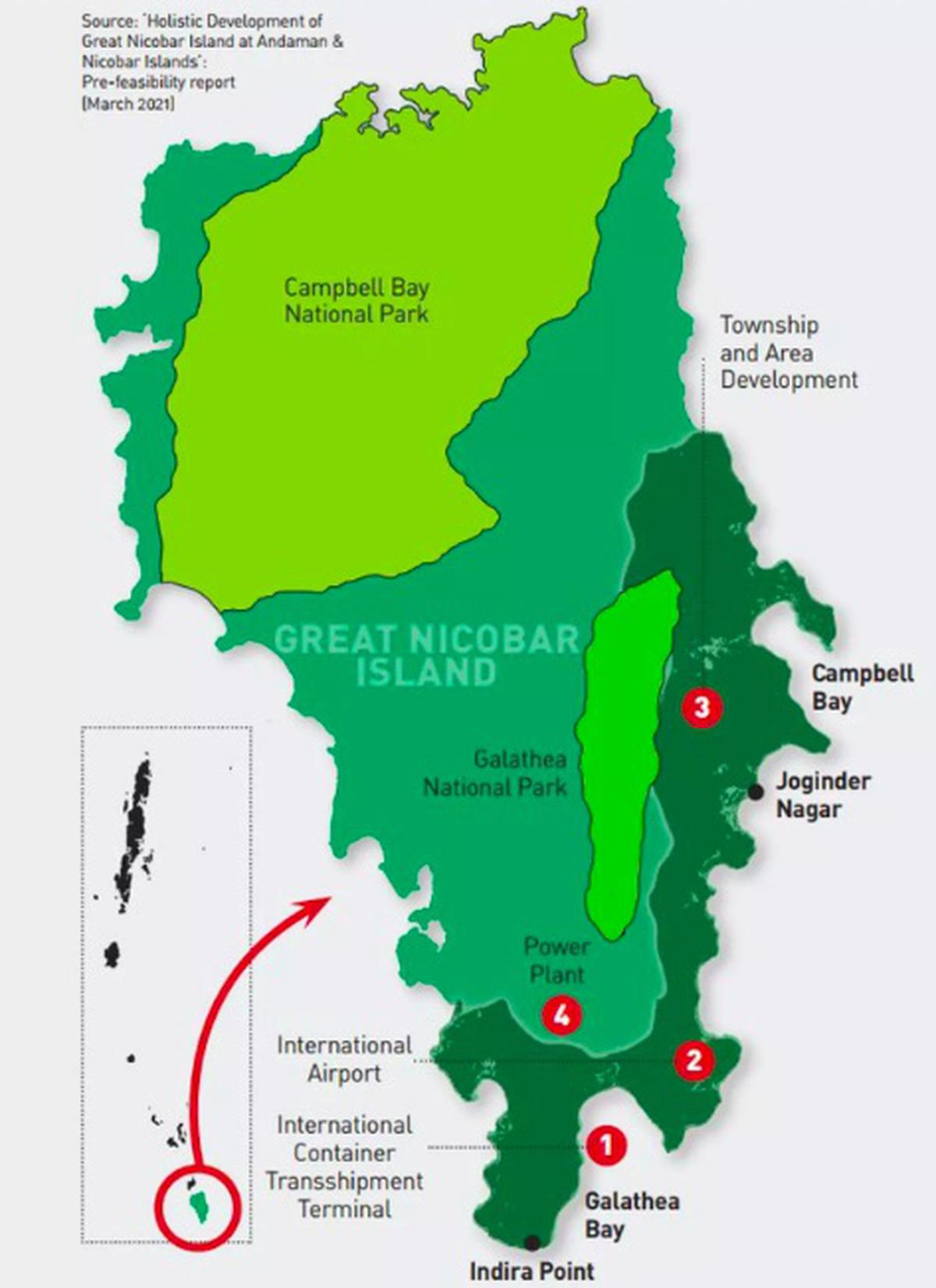
    • The GNI Project refers to the “Holistic Development of Great Nicobar Island,” a proposed mega project being piloted by NITI Aayog.
    • The project aims to develop the southern end of the Andaman and Nicobar group of Islands in the Bay of Bengal by constructing –
    1. Transshipment port
    2. Dual-use military-civil international airport
    3. Power plant and
    4. A township over a span of 30 years on more than 160 sq. km of land, of which 130 sq. km is primary forest

    Features of the Project

    • Transshipment hub of the East: The proposed port will allow Great Nicobar to participate in the regional and global maritime economy by becoming a major player in cargo transshipment.
    • Naval control: The port will be controlled by the Indian Navy, while the airport will have dual military-civilian functions and will cater to tourism as well.
    • Urban amenities: Roads, public transport, water supply and waste management facilities, and several hotels have been planned to cater to tourists.

    Significance of the project

    (1) Economic significance

    • Making India transshipment giant: The proposed port would allow GNI to become a significant player in cargo transshipment, as it is positioned equidistant from Colombo, Port Klang (Malaysia), and Singapore.
    • En-route of busiest shipping lane: It located close to the East-West international shipping corridor that sees a vast amount of the world’s shipping trade.
    • Huge source of revenue: The proposed ICTT can potentially become a hub for cargo ships travelling on this route.

    (2) Strategic significance

    • Securing IOR: The proposal to develop GNI has been on the table since the 1970s, and it has been highlighted repeatedly as a crucial element for national security and consolidation of the Indian Ocean Region.
    • Critical shipping chokepoint: Great Nicobar is equidistant from Colombo to the southwest and Port Klang and Singapore to the southeast, the region through which a very large part of the world’s shipping trade passes.
    • Oceanic outpost: The ANI is an oceanic outpost for continental India.
    • Combatting Chinese presence: In recent years, the escalating Chinese presence in the Indian Ocean has added greater urgency to this imperative.

    Issues with the Project

    • Threat to Biodiversity: The construction of the port, airport, and township, and the influx of people that the project is expected to bring, are likely to result in habitat destruction, fragmentation, and degradation, which could threaten the survival of several species.
    • Displacement of Indigenous Tribes: GNI is home to two isolated and indigenous tribes, the Shompen and the Nicobaris, who have lived on the island for thousands of years. The project could displace these tribes and disrupt their way of life and culture.
    • Deforestation: The project is expected to result in the cutting down of an estimated 8.5 lakh trees in the island’s prehistoric rainforests, which could have a significant impact on the island’s ecology and biodiversity.
    • Lack of Adequate Environmental and Social Impact Assessments: The project has received several easy clearances with uncharacteristic haste, raising questions about the adequacy of environmental and social impact assessments.
    • Fragile Topography: Experts have raised several concerns relating to the tectonic volatility and disaster vulnerability of the islands, which have experienced nearly 444 earthquakes in the past 10 years. The tribal communities, who were displaced in the 2004 Tsunami, are still recovering from its impact.

    Concerns highlighted by the NCST

    (1) Discrepancies with FRA Compliance

    • The island administration did not recognise or grant ownership of any forest land to local tribespeople as per FRA, a requisite step under the Forest Conservation Rules, 2017, before Stage-I clearance is granted.
    • This is despite the fact that Rule 6(3)(e) of Forest Conservation Rules-2017 (FCR) requires that any diversion of forest land first requires the District Collector to recognise and vest rights to locals under the FRA.
    • The legislation allows forest communities the right to control and manage the use of the forest land over which they hold titles, and their consent is mandatory for diverting it.

    (2) Inconsistencies with Stage-I Clearance

    • The Stage-I clearance for the project was granted in October 2022, two years after the application was received.
    • Monthly progress reports show that the district administration did not process any claims over forest land under the FRA in the 26 months since project sanction.
    • A Gram Sabha meeting was called with less than a day’s notice to villagers where a resolution was passed consenting to the diversion of forest land for the project.

    (3) Withdrawal of Consent

    • Weeks after the Stage-I clearance was granted, the Tribal Council at Campbell Bay withdrew the consent granted by the Gram Sabha.
    • NCST alleged that the minutes of the meeting were typed after securing members’ signatures.

    Back2Basics: National Commission for Scheduled Tribes (NCST)

    Description
    Formation NCST was set up with effect from 19th February, 2004.

    Created by inserting a new article 338A in the Constitution through the 89th Constitution Amendment Act, 2003.

    Hence a constitutional body.

    Objective To oversee the implementation of various safeguards provided to STs under the Constitution or under any other law for time being in force or under any other order to the Government and to evaluate the working of such safeguards.
    Composition It consists of a Chairperson, a Vice-Chairperson and 3 other Members who are appointed by the President by warrant under his hand and seal.

    At least one member should be a woman.

    The Chairperson, the Vice-Chairperson and the other Members hold office for a term of 3 years.

    The members are not eligible for appointment for more than two terms.

    The Chairperson has been given the rank of Union Cabinet Ministers, the Vice Chairperson has the rank of a Minister of State and other Members have the rank of a Secretary to the Government of India.


    Get an IAS/IPS ranker as your personal mentor for UPSC 2024 | Schedule your FREE session and get the Prelims prep Toolkit!

  • SC modifies judgement on Eco-Sensitive Zones

    eco

    Central idea

    • The Supreme Court modified its judgment on mandatory eco-sensitive zones (ESZs) around protected forests, national parks, and wildlife sanctuaries across the country.
    • The court has now made it clear that ESZs cannot be uniform across the country and has to be “protected area-specific.”

    What are the Eco-sensitive Zones (ESZs)?

    • Eco-Sensitive Zones (ESZs) or Ecologically Fragile Areas (EFAs) are areas notified by the MoEFCC around Protected Areas, National Parks and Wildlife Sanctuaries.
    • The purpose of declaring ESZs is to create some kind of “shock absorbers” to the protected areas by regulating and managing the activities around such areas.
    • They also act as a transition zone from areas of high protection to areas involving lesser protection.

    How are they demarcated?

    • The Environment (Protection) Act, 1986 does NOT mention the word “Eco-Sensitive Zones”.
    • However, Section 3(2)(v) of the Act, says that Central Government can restrict areas in which any industries, operations or processes or class of industries, operations or processes shall be carried out or shall not, subject to certain safeguards.
    • Besides Rule 5(1) of the Environment (Protection) Rules, 1986 states that central government can prohibit or restrict the location of industries and carrying on certain operations or processes on the basis of certain considerations.
    • The same criteria have been used by the government to declare No Development Zones (NDZs).

    Defining its boundaries

    • An ESZ could go up to 10 kilometres around a protected area as provided in the Wildlife Conservation Strategy, 2002.
    • Moreover, in the case where sensitive corridors, connectivity and ecologically important patches, crucial for landscape linkage, are beyond 10 km width, these should be included in the ESZs.
    • Further, even in the context of a particular Protected Area, the distribution of an area of ESZ and the extent of regulation may not be uniform all around and it could be of variable width and extent.

    Activities Permitted and Prohibited

    • Permitted: Ongoing agricultural or horticultural practices, rainwater harvesting, organic farming, use of renewable energy sources, and adoption of green technology for all activities.
    • Prohibited: Commercial mining, saw mills, industries causing pollution (air, water, soil, noise etc), the establishment of major hydroelectric projects (HEP), commercial use of wood, Tourism activities like hot-air balloons over the National Park, discharge of effluents or any solid waste or production of hazardous substances.
    • Under regulation: Felling of trees, the establishment of hotels and resorts, commercial use of natural water, erection of electrical cables, drastic change of agriculture system, e.g. adoption of heavy technology, pesticides etc, widening of roads.

    What was the recent SC judgment?

    • On June 3, 2022, the apex court had ordered a 1-km buffer zone for protected areas to act as a “shock absorber.”
    • However, the Centre and several states, including Kerala, had returned to the apex court seeking modification of the judgment, saying the direction affected hundreds of villages in the peripheries of forests.

    Impact of the Judgment

    • Earlier judgement would have certainly hampered the day-to-day activities of the citizens residing in ESZs.
    • It would also prevent villagers from reconstructing their houses, the government from constructing schools, dispensaries, anganwadis, and other basic structures for the improvement of the life of the villagers.
    • The court also noted that it would be impossible for forest departments to conduct eco-development activities around national parks and sanctuaries.

    Try this PYQ

    With reference to ‘Eco-Sensitive Zones’, which of the following statements is/are correct?

    1. Eco-Sensitive Zones are the areas that are declared under the Wildlife (Protection) Act, 1972
    2. The purpose of the declaration of Eco-Sensitive Zones is to prohibit all kinds of human activities, in those zones except agriculture.

    Select the correct answer using the code given below:

    (a) 1 only

    (b) 2 only

    (c) Both 1 and 2

    (d) Neither 1 nor 2


    [wpdiscuz-feedback id=”scetxnmios” question=”Please leave a feedback on this” opened=”1″]Post your answers here.[/wpdiscuz-feedback]


    Get an IAS/IPS ranker as your personal mentor for UPSC 2024 | Schedule your FREE session and get the Prelims prep Toolkit!

  • Jal Shakti Ministry plans network of Groundwater Sensors

    groundwater

    Central Idea: The Jal Shakti Ministry is working on an ambitious plan to deploy a vast network of groundwater sensors to continuously relay information on groundwater levels and contamination.

    What is Groundwater?

    • Groundwater is the water found underground in the cracks and spaces in soil, sand and rock.
    • It is stored in and moves slowly through geologic formations of soil, sand and rocks called aquifers.
    • Aquifers are typically made up of gravel, sand, sandstone, or fractured rock, like limestone.
    • Water can move through these materials because they have large connected spaces that make them permeable.
    • Aquifers, hand-dug wells, and artesian wells are different types of sources of groundwater.

    Sensors-based Groundwater Monitoring

    • Under this new initiative, around 16,000-17,000 digital water level recorders will be connected to piezometers in the wells to transmit information digitally.
    • In the next three years, the CGWB aims to increase its network from the existing 26,000 to about 40,000.
    • When combined with similar networks possessed by other institutions, India will have about 67,000 digitally recordable units to monitor groundwater dynamics.

    Significance of the move

    • This would make groundwater visible much the same way as air quality and meteorological variables
    • The information will be publicly accessible.
    • It will potentially provide groundwater forecasts to farmers that would be useful for sowing and updated advisories that can influence groundwater extraction policies by states

    Why monitor groundwater?

    • Nitrate contamination – a result of the use of nitrogenous fertilizers – has been observed in some regions
    • Groundwater contamination, mostly “geogenic” (natural), hasn’t significantly changed over the years.
    • But nitrate contamination and fluoride and arsenic contamination have been observed in some regions and states.

    Present system of monitoring

    • The Central Groundwater Board currently relies on a network of about 26 thousand groundwater observation wells.
    • It requires technicians to manually measure the state of groundwater in a region.

    Groundwater Extraction in India

    • The total annual groundwater recharge in the country has been assessed as 437.60 billion cubic meters (BCM)
    • The annual extractable groundwater resource has been assessed as 398.08 bcm, with actual extraction of 239.16 bcm
    • The average stage of groundwater extraction for the country as a whole works out to be about 60.08%, and anything above 70% is considered “critical”

    Also read

    Groundwater Extraction Lowest in 18 years


    Get an IAS/IPS ranker as your personal mentor for UPSC 2024 | Schedule your FREE session and get Prelims prep Toolkit!

  • First Census of Waterbodies in India

    water

    The Ministry of Jal Shakti has recently released the report of the first census of waterbodies in India.

    Waterbodies Census

    • It is the first ever process of conducting a comprehensive survey of all the waterbodies in a particular region or country.
    • The census aims to identify and classify different types of waterbodies like ponds, tanks, lakes, and reservoirs, among others.
    • The information can help in the development of strategies for their conservation and management.

    Major highlight: Definition of Waterbodies

    • The census defines a waterbody as a unit bounded on all sides that is used for storing water for various purposes.
    • These units can be either natural or man-made and may or may not have masonry work.
    • Waterbodies are used for a variety of purposes, such as irrigation, industrial use, pisciculture, domestic and drinking water supply, recreation, religious purposes, and groundwater recharge.
    • The report states that any structure that accumulates water from ice-melt, streams, springs, rain or drainage of water from residential or other areas or stores water by diversion from a stream, nala or river is also considered a waterbody.

    Key facts: Distribution of Waterbodies

    According to the report, India has 24.24 lakh water bodies like ponds, tanks, and lakes, with West Bengal having the highest number (7.47 lakh) and Sikkim having the least number (134).

    Waterbody Type Percentage of Total Waterbodies Number of Waterbodies
    Ponds 59.5% 14,42,993
    Tanks 15.7% 3,81,805
    Reservoirs 12.1% 2,92,280
    Water Conservation Schemes/Percolation Tanks/Check Dams 9.3% 2,26,217
    Lakes 0.9% 22,361
    Others 2.5% 58,884


    State-Wise Distribution of Waterbodies

    • The report highlights that West Bengal has the highest number of ponds and reservoirs, while Andhra Pradesh has the highest number of tanks.
    • Tamil Nadu has the highest number of lakes, and Maharashtra is the leading state with water conservation schemes.
    • South 24 Parganas district in West Bengal has been ranked as the top district having the highest (3.55 lakh) number of waterbodies across the country.

    Issues highlighted: Encroachment of Waterbodies

    • Total 1.6% of waterbodies reported to be encroached
    • 4% of encroached waterbodies in rural areas, 4.6% in urban areas
    • 8% of encroached waterbodies have less than 25% area under encroachment
    • 8% of waterbodies have more than 75% area under encroachment

    Conclusion

    • The census provides a comprehensive overview of the distribution of waterbodies in India, highlighting the states and districts with the highest number of waterbodies.
    • The data on encroachment of waterbodies can help in identifying areas where conservation efforts are needed to protect these valuable resources.


  • Species in news: Olive Ridley Turtles

    olive

    Millions of baby Olive Ridley Turtles crawled towards the Bay of Bengal after emerging from eggshells along Odisha’s Rushikulyabeach in the Ganjam district.

    Olive Ridley Turtles

    Description
    Scientific name Lepidochelys olivacea
    Habitat Warm and tropical waters
    Found in Pacific and Indian Oceans
    Nesting sites Rushikulya rookery in Odisha
    Largest mass nesting site Coast of Odisha in India
    Conservation status Vulnerable in IUCN Red List
    Listed in Schedule 1 in Wildlife Protection Act, 1972

    Special feature: Mass nesting

    Notable behavior Arribadas
    Nesting habits Synchronized mass nesting and return to the same beach where they hatched
    Nest structure Conical nests about one and a half feet deep, dug with hind flippers
    Incubation period 45 to 60 days, influenced by temperature of the sand and atmosphere


    Get an IAS/IPS ranker as your personal mentor for UPSC 2024 | Schedule your FREE session and get Prelims prep Toolkit!

  • What is Great Pacific Garbage Patch?

    pacific

    Central idea: The article reports on a recent study which found evidence that coastal life forms have colonized plastic items in the Great Pacific Garbage Patch, a vast area in the North Pacific Ocean where plastic waste has accumulated due to ocean currents.

    What is the Great Pacific Garbage Patch (GPGP)?

    Features
    Location North Pacific Subtropical Gyre (NPSG), north of the equator in the Pacific Ocean
    Currents Kuroshio, North Pacific, California, and North Equatorial currents, moving in a clockwise direction
    Sources Any trash that enters one of these currents from any of the 51 Pacific Rim countries
    Size Estimated to be 1.6 million sq. km
    Age More than 50 years old
    Plastic Content Estimated to contain 45,000-129,000 metric tonnes of plastic, predominantly in the form of microplastics
    Visible Objects Heavier, more visible objects that haven’t yet broken down into smaller particles accounted for 92% in 2018


    Findings of the new study

    • Researchers from Canada, the Netherlands, and the U.S. have reported that coastal life forms have colonized plastic items in the Great Pacific Garbage Patch.
    • From November 2018 to January 2019, they collected 105 pieces of plastic debris, the most heavily plastic-polluted ocean gyre on the globe.
    • Based on studying them, they reported that 98% of the debris items had invertebrate organisms.

    Plastic inflicting into a coastal organism

    • Organisms found on coasts were getting by on small floating islands of garbage out in the Pacific Ocean, which the researchers named the neopelagic community.
    • They found organisms belonging to 46 taxa, and 37 of them were coastal; the rest were pelagic. Among both coastal and pelagic organisms, crustaceans were the most common.
    • Nearly all taxa were of Northwest Pacific origin, including Japan.
    • Eight of the remainder were from East Asia and five specifically from Japan. Four items were from North America.
    • They found that 68% of the coastal taxa and 33% of the pelagic taxa reproduced asexually and that there was evidence of sexual reproduction among the hydroids and the crustaceans, among others.

    Implications of the findings

    • Marine plastic pollution has given rise to a new kind of standing coastal community in the open ocean.
    • The neopelagic community is not misplaced but lives on plastic items in the garbage patch, including reproducing there.
    • The finding recalls other studies that show the chemical bonding of plastic with rocks, sedimentary rocks embedded with plastic earrings in Brazil, and the formation of plastiglomerates in Hawaii.


    What is neopelagic community?

    • The neopelagic community refers to the group of organisms that inhabit the open ocean or the pelagic zone beyond the continental shelf.
    • It is characterized by deep waters with very few physical structures or substrate for organisms to attach to.
    • This community includes a wide variety of organisms, including zooplankton, fish, squid, and marine mammals, among others.
    • These organisms have adapted to survive in the open ocean environment, which can be quite challenging due to factors such as temperature fluctuations, limited food availability, and the absence of physical structures for shelter.
    • The neopelagic community is an important part of the global marine ecosystem, playing a key role in nutrient cycling and energy transfer between different levels of the food chain.


    GPGP and its impact on marine life

    • The GPGP has significant impacts on marine life due to the ingestion of plastic by marine animals, which can cause harm and even death.
    • Plastic can also entangle and suffocate marine animals, leading to the disruption of ecosystems.
    • The new study sheds light on the neopelagic community, which has adapted to living on plastic in the garbage patch.

    Plastic pollution and its environmental impact

    • Plastic pollution is a major environmental issue that affects land and water ecosystems worldwide.
    • Plastic waste can take hundreds of years to decompose, and even then, it breaks down into microplastics that can persist in the environment indefinitely.
    • The presence of plastic in the environment has negative impacts on biodiversity, ecosystem function, and human health.

    Conclusion

    • There are various solutions to plastic pollution, including reducing the use of single-use plastics, recycling, and promoting alternative materials.
    • Governments and industries can also take steps to reduce plastic waste, such as implementing policies and regulations that reduce plastic use and increase recycling.
    • Individual actions, such as reducing personal plastic consumption and properly disposing of plastic waste, can also make a difference.


  • India’s first Mangrove Pitta Birds Census conducted in Odisha

    pitta

    Central idea: The article talks about the first-ever census of mangrove pitta birds conducted in two coastal districts of Odisha, India.

    About Mangrove Pitta

    • The mangrove pitta (Pitta megarhyncha) belongs to the family of pittas, the Pittidae.
    • The mangrove pitta species is distributed in India, Bangladesh, Myanmar, Thailand, Malaysia, Singapore and Indonesia.
    • These pitta species have fragmented distribution and considered ‘Near Threatened’ by IUCN. These pittas are monotypic species.

    Focus of the Census

    • In this census, a total of 179 individual mangrove pitta birds were counted.
    • The census mainly focused on the mangrove patches along the coasts of Kendrapara and Jagatsingpur districts.
    • Information was collected on the distribution, habitat, and breeding of mangrove pittas along the coastal mangroves.
    • The census was carried out by point count method, either by walking in the forest or using country boats in the creeks.