💥Join UPSC 2027,2028 Mentorship (August Batch) + XFactor Notes & Microthemes PDF

Subject: Space Technology

  • Subsurface Lunar Ice Discovery (Chandrayaan-2)

    Why in the news?

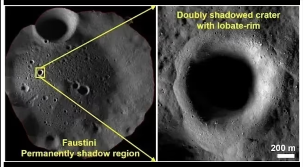
    Scientists from the Physical Research Laboratory (PRL) used data from Chandrayaan-2’s Dual Frequency Synthetic Aperture Radar (DFSAR) to discover strong evidence of subsurface water-ice near the Moon’s South Pole.

    Key Findings

    • Target Location: Four “doubly shadowed craters” located inside Permanently Shadowed Regions (PSRs) at the lunar south pole.
    • Extreme Thermal Environment: These locations are permanently shielded from solar radiation, maintaining temperatures around 25 Kelvin (-248°C), acting as ideal cold traps to preserve volatiles.
    • The Prime Candidate: A 1.1 km diameter micro-crater located within the larger Faustini Crater showed the highest probability of containing clean subsurface ice.

    Geomorphological Evidence

    • Lobate-Rim Morphology: The highly-evident 1.1 km crater exhibits flow-like, lobed patterns along its rim.
    • Geological Meaning: This indicates that the initial meteoroid impact likely penetrated a layer of subsurface ice, melting it briefly to create a slurry-like, fluid ejecta pattern before re-freezing.

    About Chandrayaan-2 & DFSAR

    • Mission Context: Launched in July 2019; while its Vikram lander failed to make a soft landing, the orbiter remains fully functional in lunar orbit.
    • DFSAR Instrument: Dual Frequency Synthetic Aperture Radar.
    • Capabilities: It is the first fully polarimetric radar sent to the Moon, operating across L-band and S-band microwave frequencies to penetrate deep into the lunar regolith.

    Significance

    • In-Situ Resource Utilization (ISRU): Essential for future crewed bases (such as Artemis or India’s planned lunar base) to harvest local water for life support and rocket fuel production.
    • Strategic Mapping: Provides high-fidelity targeting data for future landing and excavation missions, including India’s upcoming Chandrayaan missions.

    Challenges

    • Accessing Cold Traps: Operating mechanical equipment in permanent darkness at 25 Kelvin presents immense engineering challenges.
    • Regolith Depth Overburden: The ice is subsurface, requiring specialized drilling and extraction systems rather than surface scraping.

    [2017] The terms ‘Event Horizon’, ‘Singularity’, ‘String Theory’ and ‘Standard Model’ are sometimes seen in the news in the context of

    [A] Observation and understanding of the Universe

    [B] Study of the solar and the lunar eclipses

    [C] Placing satellites in the orbit of the Earth

    [D] Origin and evolution of living organisms on the earth

  • Chandrayaan-3 ‘Hop’ Experiment Reveals Layered Lunar Surface

    Why in the News?

    Scientists analysing data from Chandrayaan-3 discovered that the Moon’s upper surface near the landing site has two distinct layers within a few centimetres of depth.

    Key Findings

    • The lunar surface (regolith) is not uniform.
    • A loose porous upper layer quickly changes into a denser compact layer:
      • About 2 to 6 cm below the surface.

    Role of the ‘Hop’ Experiment

    • Chandrayaan-3 lander performed a small “hop”.
    • The lander:
      • Lifted about 40 cm above the surface
      • Moved nearly 50 cm before landing again

    ChaSTE Instrument

    • The findings are based on data from Chandra’s Surface Thermophysical Experiment (ChaSTE)

    Function

    • Measured thermal properties and temperature profile of lunar soil.
    • Used a rod-shaped probe with temperature sensors.

    Important Discoveries

    • Even at 6-9 cm depth, the Moon showed layered structure.
    • Temperature dropped sharply with depth:
      • Around 60°C lower at 10 cm depth compared to the surface.
    [2016] Consider the following statements: The Mangalyaan launched by ISRO 
    1. is also called the Mars Orbiter Mission 
    2. made India the second country to have a spacecraft orbit the Mars after USA 
    3. made India the only country to be successful in making its spacecraft orbit the Mars in its very first attempt 
    Which of the statements given above is/are correct? 
    [A] 1 only [B] 2 and 3 only [C] 1 and 3 only [D] 1, 2 and 3
  • Mexico City Subsidence and NISAR Satellite 

    Why in the News

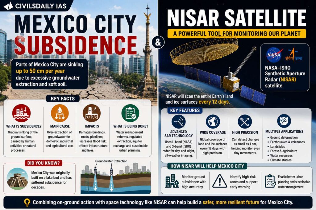
    New imagery from the NISAR satellite has shown that Mexico City is sinking at an alarming rate of nearly 25 cm per year, mainly due to excessive groundwater extraction.

    What is Land Subsidence

    • Gradual sinking or settling of the Earth’s surface
    • Commonly caused by:
      • Excessive groundwater withdrawal
      • Mining
      • Natural geological processes

    Why is Mexico City Sinking

    • Built on an ancient lake bed
    • Heavy extraction of groundwater from aquifers
    • Rapid urbanisation and infrastructure load
    • Shrinking aquifers causing ground compaction

    About NISAR Satellite

    • NASA and Indian Space Research Organisation (ISRO) joint mission
    • Full Form: NASA ISRO Synthetic Aperture Radar

    Features of NISAR

    • Uses Synthetic Aperture Radar (SAR)
    • Can detect surface changes in real time
    • Works in:
      • Day and night
      • All weather conditions
    [2019] For the measurement/ estimation of which of the following are satellite images/remote sensing data used? 
    1. Chlorophyll content in the vegetation of a specific location 
    2. Greenhouse gas emissions from rice paddies of a specific location 
    3. Land surface temperatures of a specific location 
    Select the correct answer using the code given below. 
    [A] 1 only [B] 2 and 3 only [C] 3 only [D] 1, 2 and 3
  • How dual-use satellites are blurring the lines of modern space war

    Why in the News?

    There is a critical shift in the nature of modern warfare. The dual-use satellites power civilian life, but at the same time are increasingly becoming instruments of covert warfare. There is growing weaponisation of civilian space infrastructure without physical destruction. Unlike earlier conceptions of space war involving kinetic attacks, recent developments show a shift toward cyber-attacks, signal jamming, and spoofing, as seen during the Russia-Ukraine conflict (2022) where the Viasat KA-SAT network was disrupted, crippling communications across Europe. This marks a paradigm shift, from visible destruction to invisible disruption. 

    What are Dual-use satellites?

    1. They are platforms that serve both civilian/commercial and military/national security purposes, often simultaneously or interchangeably. 
    2. These technologies, such as Earth observation or communication satellites, provide commercial services (e.g., mapping, internet) while also supplying intelligence-grade imagery, navigation, and encrypted communications for defense forces.

    How are dual-use satellites transforming the nature of warfare?

    1. Dual-use infrastructure: Enables simultaneous civilian and military utilisation of GPS, broadband, and communication systems.
    2. Military integration: Facilitates intelligence gathering, surveillance, reconnaissance, and drone targeting.
    3. Operational dependency: Increases reliance of armed forces on commercial satellite constellations.
    4. Target ambiguity: Obscures distinction between legitimate military targets and protected civilian assets.
    5. Strategic leverage: Converts civilian systems into force multipliers without dedicated military deployment
    6. Example: Civilian GPS systems enabling precision-guided military operations

    Why does modern space conflict avoid physical destruction?

    1. Non-kinetic techniques: Utilises cyberattacks, signal jamming, spoofing, and hacking
    2. Debris avoidance: Prevents creation of orbital debris that can damage own satellites
    3. Cost efficiency: Reduces financial and technological burden compared to kinetic weapons
    4. Escalation control: Maintains conflict below threshold of overt war
    5. Reversibility: Allows temporary disruption instead of permanent destruction
    6. Example: Viasat KA-SAT cyberattack disrupted communications without physical damage.

    How does the invisibility of cyber warfare weaken deterrence?

    1. Attribution uncertainty: Limits ability to conclusively identify attackers
    2. Proxy warfare: Enables operations through third-party actors and intermediaries
    3. Evidentiary challenges: Lacks visible proof compared to physical attacks
    4. Delayed response: Slows decision-making for retaliation due to ambiguity
    5. Deterrence erosion: Weakens threat of retaliation as attackers remain unidentified
    6. Outcome: Encourages repeated low-intensity attacks below war threshold

    Why is the legal framework inadequate for space cyber warfare?

    1. Outer Space Treaty gap: Focuses on physical weaponisation, excludes cyber operations
    2. UN Charter ambiguity: Article 2(4) unclear on cyber disruptions as “use of force”
    3. International Humanitarian Law (IHL) limitations: Difficulty in applying civilian-military distinction in dual-use systems.
    4. Attribution requirement: Legal responsibility contingent on high evidentiary standards.
    5. Enforcement deficit: Absence of binding mechanisms for compliance and accountability
    6. Example: Cyberattacks on satellites fall outside clearly defined war thresholds

    How is the civilian-military distinction collapsing in space?

    1. Dual-use systems: Civilian satellites routinely support military operations
    2. Legal contradiction: IHL mandates distinction, but technology merges functions
    3. Operational overlap: Commercial constellations provide services to armed forces
    4. Target legitimacy confusion: Civilian assets become potential military targets
    5. Protection erosion: Reduces safeguards for civilian infrastructure
    6. Example: Commercial satellites used for intelligence and battlefield coordination

    What risks do cyber intrusions in space systems pose to society?

    1. Critical infrastructure exposure: Financial systems, aviation, and energy depend on satellites
    2. Cascading failures: Disruption in one system triggers failures across sectors
    3. Navigation risks: GPS spoofing misguides aircraft and maritime vessels
    4. Economic disruption: Interrupts banking, stock markets, and digital payments
    5. Governance paralysis: Affects emergency services and state communication networks
    6. Example: Communication blackout due to satellite cyberattack affecting multiple countries.

    Why is there a need for enforceable norms in space governance?

    1. Normative gaps: Existing frameworks remain advisory without enforcement
    2. Threshold ambiguity: Lack of clarity on what constitutes an act of war in cyberspace
    3. Attribution mechanisms: Requires international cooperation for real-time identification
    4. Collective security: Strengthens coordinated response to cross-border cyber threats
    5. Standardisation: Establishes clear operational and legal guidelines for space conduct
    6. Outcome: Reduces ambiguity and strengthens deterrence

    Conclusion

    Space warfare is evolving into a domain defined by invisible disruption, legal ambiguity, and systemic risk. The fusion of civilian and military systems creates vulnerabilities that extend beyond conflict zones into everyday life. Strengthening legal clarity, attribution capacity, and enforceable norms remains essential for maintaining stability in the space domain.

    PYQ Relevance

    [UPSC 2022] What are the different elements of cyber security? Keeping in view the challenges in cyber security, examine the extent to which India has successfully developed a comprehensive National Cyber Security Strategy.

    Linkage: The PYQ directly relates to cyber threats in critical infrastructure, now extended to space-based systems like satellites. It highlights gaps in attribution, deterrence, and regulatory frameworks, which are central to dual-use satellite warfare.
  • Mission Drishti (OptoSAR Satellite)

    Why in the News

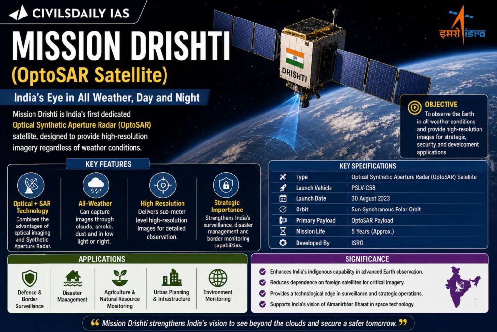
    India’s private space startup GalaxEye has launched Mission Drishti, the country’s largest privately developed Earth observation satellite, aboard Falcon 9 by SpaceX.

    Key Facts

    • Satellite: Mission Drishti
    • Weight: 190 kg
    • Launch site: Vandenberg, California
    • Developed by: GalaxEye (Bengaluru)
    • Category: Earth Observation Satellite

    Unique Feature

    • First satellite globally to combine:
      • Electro Optical (EO) imaging
      • Synthetic Aperture Radar (SAR)
    • Known as OptoSAR technology

    What is OptoSAR?

    • Integration of:
      • Optical imaging (visible spectrum)
      • Radar imaging (microwave signals)
    • Enables:
      • All weather imaging
      • Day and night observation

    Key Concepts

    Electro Optical (EO) Sensors

    • Capture images using visible and infrared light
    • Affected by cloud cover and darkness

    Synthetic Aperture Radar (SAR)

    • Uses radio waves
    • Works in all weather conditions and at night

    Applications

    • Defence and surveillance
    • Agriculture monitoring
    • Disaster management
    • Maritime surveillance
    • Infrastructure planning

    Institutional Context

    • Supported by IN-SPACe
    • Part of India’s growing private space ecosystem
    • Complements ISRO missions
    [2019] For the measurement/ estimation of which of the following are satellite images/remote sensing data used? 
    1. Chlorophyll content in the vegetation of a specific location 
    2. Greenhouse gas emissions from rice paddies of a specific location 
    3. Land surface temperatures of a specific location 
    Select the correct answer using the code given below. 
    [A] 1 only
    [B] 2 and 3 only
    [C] 3 only
    [D] 1, 2 and 3
  • Curiosity Rover  

    Why in the News?

    • The Curiosity Rover has detected organic molecules on Mars, strengthening evidence about the planet’s past habitability.

    What is Curiosity Rover

    • A robotic rover sent by NASA
    • Part of: Mars Science Laboratory (MSL) mission
    • Objective: Explore Mars’ surface and assess habitability

    Launch & Landing

    • Launch: November 26, 2011
    • Launch vehicle: Atlas V rocket
    • Landing: August 5, 2012

    Landing Site

    • Located in: Gale Crater
    • Explores: Mount Sharp

    Unique Landing Technology

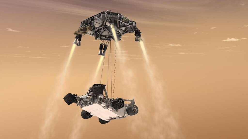
    • Used: Sky Crane technique
    • Process:
      • Parachute descent
      • Rocket-powered hovering
      • Rover lowered gently to surface
    [2016] Consider the following statements: The Mangalyaan launched by ISRO 
    1. is also called the Mars Orbiter Mission 
    2. made India the second country to have a spacecraft orbit the Mars after USA 
    3. made India the only country to be successful in making its spacecraft orbit the Mars in its very first attempt 
    Which of the statements given above is/are correct? 
    [A] 1 only [B] 2 and 3 only [C] 1 and 3 only [D] 1, 2 and 3
  • Gaganyaan-1 Crew Module Successfully Completes Air Drop Test

    Why in the News?

    ISRO successfully conducted the Gaganyaan-1 Crew Module air drop test off the Andhra Pradesh coast, marking another step toward India’s first human spaceflight mission.

    Key Highlights

    • Test Agency: ISRO
    • Location: Bay of Bengal near Satish Dhawan Space Centre (SHAR)
    • Aircraft Used: Indian Air Force Chinook helicopter
    • Drop Height: About 3 km altitude
    • Module Weight: 5.7 tonnes (simulated crew module)
    • Recovery: Indian Navy

    What is Crew Module

    • Pressurised capsule at the top of spacecraft
    • Houses astronauts
    • Designed for safe re-entry and splashdown
    • Equipped with parachute-based landing system

    About Gaganyaan Mission

    • India’s first human spaceflight mission
    • Planned by ISRO
    • Mission Structure:
      • 3 Uncrewed missions
      • 1 Crewed mission
    [2025] Consider the following space missions: 
    1 Axiom-4 
    2 SpaDeX 
    3 Gaganyaan  
    How many of the space missions given above encourage and support microgravity research?
    (a) Only one (b) Only two (c) All the three (d) None
  • Indian Scientists Develop New Method to Measure Distances in Deep Space

    Why in the News?

    Indian astronomers, including researchers from IIT Kanpur, have developed a new technique to measure distances in space using pulsars by combining dispersion measure and scatter broadening.

    What are Pulsars?

    • Pulsars are dense, rapidly spinning neutron stars
    • Emit regular radio wave pulses
    • Act as cosmic clocks due to highly stable rotation
    • Used to detect gravitational waves and deep space phenomena

    New Measurement Method

    Scientists combined two effects:

    1. Dispersion Measure (DM)

    • Radio waves pass through ionised gas
    • Lower frequency waves arrive later
    • Used to estimate distance

    2. Scatter Broadening

    • Plasma irregularities scatter signals
    • Signals follow multiple paths
    • Causes signal stretching

    New Approach

    • Combined Dispersion + Scattering
    • Improves accuracy of distance measurement

    Study Details

    • Observed 10 pulsars
    • Region studied: Gum Nebula
    • Found Vela Pulsar located behind nebula
    • Developed improved electron distribution model

    Significance

    • More accurate deep space distance measurement
    • No strict distance limitation
    • Can be used for Fast Radio Bursts (FRBs)
    • Improves understanding of interstellar medium
    [2023] Consider the following pairs: Objects in space : Description 
    1 Cepheids : Giant clouds of dust and gas in space 
    2 Nebulae : Stars which brighten and dim periodically 
    3 Pulsars : Neutron stars that are formed when massive stars run out of fuel and collapse 
    How many of the above pairs are correctly matched? 
    (a) Only one (b) Only two (c) All three (d) None
  • Record Space Activity in 2025: ISSAR Report

    Why in the News?

    The Indian Space Situational Assessment Report (ISSAR) 2025 revealed 315 global space launches in 2025, placing 4,651 objects into orbit.

    Global Space Activity 2025

    • Total launches: 315
    • Objects placed in orbit: 4,651
    • Objects re entered atmosphere: 1,911
    • Net growth in space objects: 74.5%

    India’s Space Assets

    Satellites

    • Total Indian satellites in orbit: 86
      • Operational: 27
      • Defunct: 23
      • Decayed: 36
    • Indian satellites launched in 2025: 8

    Rocket Bodies

    • 4 rocket bodies placed in orbit
    • 12 Indian objects re entered atmosphere
    [2022] Which one of the following statements best reflects the idea behind the “Fractional Orbital Bombardment System” often talked about in media?
    (a) A hypersonic missile is launched into space to counter the asteroid approaching the Earth and explode it in space.
    (b) A spacecraft lands on another planet after making several orbital motions.
    (c) A missile is put into a stable orbit around the Earth and deorbits over a target on the Earth.
    (d) A spacecraft moves along a comet with the same speed and places a probe on its surface.
  • How NASA will fly astronauts to the Moon and back for Artemis II

    Why in the News?

    NASA is set to launch Artemis II, the first crewed lunar mission since the Apollo era (1972), carrying four astronauts on a flyby trajectory around the Moon. It represents the first human return to deep space in over 50 years and the first time the Space Launch System (SLS) and Orion spacecraft will carry astronauts together.

    Why is Artemis II considered a historic milestone in space exploration?

    1. First Crewed Lunar Mission Since Apollo: Re-establishes human presence beyond low Earth orbit after 1972, marking a generational shift in exploration capability.
    2. Deep Space Human Travel: Ensures astronauts travel ~6,500 km beyond the Moon, the farthest distance humans have ever reached.
    3. Technological Transition: Validates next-generation systems replacing Saturn V and Apollo modules.
    4. Geopolitical Significance: Reinforces leadership in space amid rising competition (e.g., China’s lunar ambitions).
    5. Programmatic Continuity: Bridges Artemis I (uncrewed) and Artemis III (lunar landing).

    How does Artemis II’s trajectory and mission profile differ from earlier missions?

    1. Lunar Flyby Trajectory: Ensures a non-landing mission with orbital path around the Moon and return to Earth.
    2. Duration Optimization: Facilitates a ~10-day mission, shorter than robotic missions but efficient for human travel.
    3. Distance Benchmark: Extends human reach beyond Apollo missions, which remained closer (~400 km lunar orbit).
    4. Earth Orbit Phasing: Includes two Earth orbits before translunar injection, unlike direct Apollo launches.
    5. Splashdown Recovery: Maintains ocean landing protocol for safe retrieval.

    What technological advancements distinguish Artemis II from Apollo missions?

    1. Space Launch System (SLS): Ensures higher thrust capacity, surpassing Saturn V in operational configuration.
    2. Orion Spacecraft: Facilitates advanced life-support, navigation, and radiation shielding systems.
    3. Extended Duration Capability: Supports ~25-day endurance, compared to shorter Apollo missions.
    4. Modern Avionics: Integrates autonomous navigation and improved communication systems.
    5. Reusability Elements: Promotes partial reusability, unlike fully expendable Apollo systems.

    What challenges and risks are associated with Artemis II?

    1. Weather Sensitivity: Launch delays due to unfavorable conditions (reported 80% favorable window).
    2. Technological Validation Risks: First crewed use of SLS-Orion combination increases uncertainty.
    3. Deep Space Radiation Exposure: Extends astronaut exposure beyond Earth’s magnetosphere.
    4. Cost Constraints: High financial burden compared to earlier programs.
    5. Mission Complexity: Multi-stage trajectory and long-duration spaceflight increase operational risk.

    How does Artemis II contribute to future lunar and interplanetary missions?

    1. System Validation: Ensures reliability of life-support, propulsion, and navigation systems.
    2. Gateway Preparation: Supports future Lunar Gateway space station development.
    3. Lunar Landing Readiness: Facilitates Artemis III mission planning and execution.
    4. Mars Mission Foundation: Provides experience for long-duration deep space travel.
    5. Commercial Integration: Encourages private sector participation in space logistics.

    Conclusion

    Artemis II represents a transitional mission that bridges past achievements with future ambitions. It validates technologies, extends human reach into deep space, and lays the foundation for sustained lunar exploration and eventual Mars missions.

    PYQ Relevance

    [UPSC 2023] What is the main task of India’s third moon mission which could not be achieved in its earlier mission? List the countries that have achieved this task. Introduce the subsystems in the spacecraft launched and explain the role of the Virtual Launch Control Centre at the Vikram Sarabhai Space Centre which contributed to the successful launch from Srihari Kota.

    Linkage: The PYQ tests understanding of lunar mission objectives, spacecraft subsystems, and launch technologies, core to GS-III (Science & Tech) with emphasis on applied space capabilities. Artemis II similarly focuses on system validation (SLS-Orion) before lunar landing, paralleling Chandrayaan-3’s shift from failure to successful soft-landing capability.