💥Join UPSC 2027,2028 Mentorship (August Batch) + XFactor Notes & Microthemes PDF

Subject: Space Technology

  • Earth’s orbits are filling up because governance hasn’t kept pace

    Why in the News?

    Earth’s orbital space is transitioning from an open, sparsely used domain to a congested and commercially exploited environment. The issue has gained prominence due to the unprecedented surge in satellite launches, particularly large constellations like Starlink, enabled by reusable rocket technology. This marks a sharp shift from earlier state-controlled, low-density space activity to high-frequency, private-led deployments. The alarming rise in orbital debris, coupled with the absence of verifiable compliance mechanisms and enforceable global regulations, has exposed a major governance failure.

    Why is Earth’s orbital environment becoming increasingly congested and fragile?

    1. Commercial Expansion: Rapid increase in private satellite constellations has multiplied objects in orbit; Example: SpaceX’s Starlink deployment at scale.
    2. Reduced Launch Costs: Reusable rockets have lowered costs significantly, enabling frequent launches.
    3. Fragmentation Events: Collisions generate thousands of debris fragments, amplifying risks exponentially.
    4. Cumulative Congestion: Orbital space is finite; increasing density raises collision probability over time.
    5. Tracking Limitations: Small debris (even coin-sized) cannot be consistently tracked but can destroy satellites.

    What governance gaps are responsible for the current crisis?

    1. Lack of Verification Mechanisms: No regular system to verify whether operators safely dispose of satellites post-mission.
    2. Pre-launch Reliance: Regulators depend on company declarations rather than post-launch compliance checks.
    3. Fragment Identification Limits: Authorities cannot reliably identify debris origin until damage occurs.
    4. Weak Monitoring Infrastructure: Absence of global, transparent tracking systems accessible to all countries.
    5. Non-binding Norms: Existing guidelines rely on voluntary compliance without enforcement or penalties.
      1. UN Space Debris Mitigation Guidelines (2007): Adopted by the UN Committee on the Peaceful Uses of Outer Space (UNCOPUOS); provides best practices for limiting debris but has no legal enforcement.
      2. IADC (Inter-Agency Space Debris Coordination Committee) Guidelines: Technical recommendations followed by major space agencies; purely voluntary and not legally binding.
      3. Long-Term Sustainability (LTS) Guidelines (2019): Developed under UNCOPUOS to promote safe and sustainable space operations; depends on self-reporting and voluntary adoption.
      4. National-level licensing norms (e.g., US FCC, others): Often incorporate mitigation principles but lack uniform global enforcement, leading to regulatory gaps. 

    Why are existing international space laws inadequate for present challenges?

    1. Outdated Frameworks: Treaties were designed for a state-dominated, low-activity era.
    2. Outer Space Treaty Limitations: Assigns responsibility to states but lacks provisions to regulate private actors effectively.
      1. State-Centric Liability: Holds states responsible, not private companies directly.
      2. No Uniform Regulation: Leaves licensing and supervision to national laws.
      3. No Enforcement Mechanism: Lacks monitoring, verification, or penalties.
      4. Reactive Liability: Applies only after damage, not for prevention.
      5. Regulatory Fragmentation: Different national laws enable forum shopping.
      6. Outdated Framework: Does not account for large private constellations.
      7. Weak Dispute Resolution: Relies on slow state-to-state processes. 
    3. Absence of Liability Enforcement: No preventive liability mechanisms; action occurs only after damage.
    4. Innovation-Regulation Gap: Rapid private innovation has outpaced slow-moving international law.
    5. No Congestion Thresholds: Lack of defined limits for “acceptable” orbital crowding.

    How does orbital debris pose systemic risks to space infrastructure?

    1. High-Velocity Threat: Even small debris travels at orbital speeds, capable of disabling satellites.
    2. Cascade Effect (Kessler Syndrome): Collisions generate more debris, triggering chain reactions.
    3. Operational Disruptions: Satellites used for communication, GPS, and weather forecasting face increasing risks.
    4. Economic Losses: Damage to satellites leads to high replacement costs and service disruptions.
    5. Strategic Vulnerability: Space assets critical for defense and surveillance become exposed.

    What ethical and intergenerational concerns arise in orbital governance?

    1. Common Resource Ethics: Space is a global commons requiring shared responsibility.
    2. Intergenerational Equity: Current actions risk limiting future access to orbital resources.
    3. Precautionary Principle: Uncertainty should not justify inaction in preventing long-term damage.
    4. Unequal Burden Sharing: Responsible operators bear higher costs compared to non-compliant actors.
    5. Global Inequality: Developing countries face barriers in accessing already congested orbits.

    What role can India play in shaping responsible orbital governance?

    1. Policy Leadership: Opportunity to shape global norms through national legislation.
    2. Balanced Approach: Combines cost-effective space missions with sustainability concerns.
    3. Regulatory Framework Development: Licensing conditions can enforce debris mitigation.
    4. Global Norm Advocacy: India can push for enforceable international agreements.
    5. Technological Innovation: Investment in debris tracking and removal technologies. 

    Conclusion

    Orbital congestion represents a governance failure in managing a global commons. Transition from voluntary norms to enforceable regulations is essential. Sustainable space use requires integrating technological capability with ethical responsibility and international cooperation.

    PYQ Relevance

    [UPSC 2019] What is India’s plan to have its own space station and how will it benefit our space programme?

    Linkage: The PYQ tests understanding of India’s evolving space ambitions and long-term capabilities. The expansion of space infrastructure increases orbital activity, reinforcing concerns of congestion, debris, and the need for stronger global space governance.
  • NASA Artemis II: How Astronauts Will Fly to the Moon and Back

    Why in the News?

    NASA’s Artemis II mission is scheduled for launch, marking the first human mission to the Moon’s vicinity since 1972 Apollo missions.

    Artemis II Mission Overview

    • Mission: Artemis II
    • Agency: NASA
    • Type: Crewed lunar flyby
    • Duration: ~10 days
    • Astronauts: 4 astronauts
    • Launch Site: Kennedy Space Center, Florida
    • Landing: Splashdown in ocean

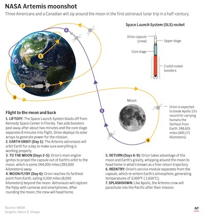
    Mission Path (Step by Step)

    1. Launch from Earth

    • Rocket: Space Launch System (SLS)
    • Spacecraft: Orion Crew Capsule
    • Launch from Kennedy Space Center

    2. Earth Orbit

    • Orion will make two orbits around Earth
    • Systems check and trajectory adjustment

    3. Journey to Moon

    • Travel time: 3 to 4 days
    • Similar to Apollo missions
    • Why fast?
    • SLS rocket is extremely powerful
    • Shorter route requires more fuel but less time

    4. Lunar Flyby

    • Orion will circle the Moon
    • Distance from far side of Moon: ~6,500 km
    • Farthest humans have ever travelled in space

    5. Return Journey

    • Orion returns to Earth
    • Travel time: 3 to 4 days

    6. Re-entry and Splashdown

    • Spacecraft re-enters Earth’s atmosphere
    • Ocean splashdown landing

    Why Some Missions Take Longer (Like Chandrayaan 3)

    • Fuel-efficient route used by many missions
    • Takes weeks to months
    • Lower fuel requirement
    • Artemis II uses: Shorter but fuel-intensive route and Faster travel
    [2016] Consider the following statements: 1 The Mangalyaan launched by ISRO is also called the Mars Orbiter Mission 2 made India the second country to have a spacecraft orbit the Mars after USA 3 made India the only country to be successful in making its spacecraft orbit the Mars in its very first attempt Which of the statements given above is/are correct? (a) 1 only (b) 2 and 3 only (c) 1 and 3 only (d) 1, 2 and 3
  • Indian Scientists Crack the Solar Radio Burst Mystery

    Why in the news?

    Researchers from the Indian Institute of Astrophysics IIA solved a long standing mystery of solar radio bursts, a breakthrough that could improve space weather forecasting and protect satellites, communication and navigation systems.

    What Are Type II Solar Radio Bursts?

    • Generated by Solar Flares and Coronal Mass Ejections CME
    • Produced by Shock waves in Sun’s Corona
    • Travel at Nearly 1000 km per second
    • Important for Space Weather Forecasting

    What Was the Long Standing Mystery?

    Scientists observed two radio emissions

    Fundamental Emission
    Harmonic Emission

    Earlier Expectation: Fundamental emission should be stronger

    But Observations Showed

    • Sometimes Harmonic emission stronger
    • This puzzled scientists for decades

    What Did Indian Scientists Discover?

    Researchers found

    • Strength depends on Location of Solar Activity
    Higher Solar Longitudes beyond 75 degree. Harmonic emission stronger

    Near centre of solar disk Fundamental emission stronger

    Why Does This Happen?

    Scientists identified two main reasons

    • Refraction in Solar Corona
    • Viewing Angle from Earth

    How Was the Study Conducted?

    • Analysed 58 Solar Events
    • Used Global CALLISTO Network
    • Used Gauribidanur Radio Observatory Karnataka
    • Published in Solar Physics Journal

    What Is CALLISTO Network?

    Global solar radio monitoring network
    • Tracks Solar radio bursts
    • Used for Space weather prediction

    [2022] If a major solar storm (solar flare) reaches the Earth, which of the following are the possible effects on the Earth? 1 GPS and navigation systems could fail. 2 Tsunamis could occur at equatorial regions. 3 Power grids could be damaged. 4 Intense auroras could occur over much of the Earth. 5 Forest fires could take place over much of the planet. 6 Orbits of the satellites could be disturbed. 7 Shortwave radio communication of the aircraft flying over polar regions could be interrupted. Select the correct answer using the code given below: (a) 1, 2, 4 and 5 only (b) 2, 3, 5, 6 and 7 only (c) 1, 3, 4, 6 and 7 only (d) 1, 2, 3, 4, 5, 6 and 7
  • Artemis II: NASA’s Moon missions could lay ground for deeper space exploration 

    Why in the News?

    Artemis II is important because it will be the first crewed mission to the Moon since Apollo 17 in 1972, ending a gap of over 50 years. Unlike Apollo’s short visits, it aims to support long-term human presence through lunar bases and continuous missions. It also involves private companies and multiple countries, showing a shift toward a global space race. The mission is now planned for 2026, marking a major step toward future Moon and Mars exploration.

    What is Artemis II?

    1. Artemis II is NASA’s first crewed mission of the Artemis program, scheduled to launch on April 1, 2026. 
    2. It will send a crew of four on a 10-day journey around the Moon, marking the first time humans have ventured beyond low Earth orbit since the Apollo 17 mission in 1972.

    Key Mission Details

    1. Objective: To test the Space Launch System (SLS) rocket and the Orion spacecraft’s life-support systems with a crew on board.
    2. Trajectory: The mission will follow a “free-return trajectory,” flying around the far side of the Moon and using lunar gravity to swing back toward Earth without entering lunar orbit.
    3. The Crew:
      1. Reid Wiseman (Commander): NASA.
      2. Victor Glover (Pilot): NASA, the first person of colour on a lunar mission.
      3. Christina Koch (Mission Specialist): NASA, the first woman on a lunar mission.
      4. Jeremy Hansen (Mission Specialist): Canadian Space Agency (CSA), the first non-American on a lunar mission.
    4. Launch Site: Launch Complex 39B at NASA Kennedy Space Center in Florida.
    5. Splashdown: The mission is expected to conclude with a splashdown in the Pacific Ocean off the coast of San Diego.

    How does Artemis II mark a shift from exploration to habitation?

    1. Mission Objective Shift: Ensures transition from short-term lunar visits to sustained human presence; Apollo missions lasted 12 days, Artemis envisions prolonged stays.
    2. Infrastructure Development: Facilitates creation of permanent bases like the Moon Gateway; supports long-term habitation and logistics.
    3. Technological Evolution: Strengthens reusable systems and deep-space capabilities; contrasts Apollo’s one-time mission design.
    4. Human Adaptation Focus: Promotes research on survival in extreme environments; essential for Mars missions.

    Why is a permanent lunar base critical for deep space exploration?

    1. Strategic Staging Ground: Enables Moon as a launchpad for Mars missions; reduces cost and energy requirements.
    2. Resource Utilization: Supports extraction of lunar resources (e.g., water ice); enables in-situ fuel production.
    3. Continuous Research: Ensures uninterrupted scientific experimentation; example: long-duration biological studies.
    4. Operational Efficiency: Facilitates reuse of materials and infrastructure; reduces dependency on Earth.

    What role do private players and global partnerships play?

    1. Commercial Integration: Enables participation of companies like SpaceX; ensures cost efficiency and innovation.
    2. International Collaboration: Strengthens cooperation among nations; example: Artemis Accords participation.
    3. Geopolitical Competition: Reflects emerging rivalry with China’s lunar plans; indicates multi-polar space race.
    4. Shared Infrastructure: Promotes joint use of space stations and bases; reduces duplication of efforts.

    How is Artemis II advancing technological frontiers?

    1. Deep Space Systems: Strengthens Orion spacecraft capabilities; supports long-duration missions.
    2. Nuclear Propulsion Research: Promotes faster interplanetary travel; example: NASA’s DRACO mission concept.
    3. Sustainability Models: Ensures closed-loop life support systems; reduces resource dependency.
    4. Cost Dynamics: Highlights high cost (~$400,000/kg); necessitates innovation in reusable technologies.

    What are the challenges and risks associated with Artemis missions?

    1. High Costs: Limits scalability of missions; requires sustained funding.
    2. Technological Uncertainty: Involves untested systems like nuclear propulsion; increases mission risk.
    3. Geopolitical Tensions: Intensifies competition with China and others; risks fragmentation of space governance.
    4. Human Survival Risks: Exposes astronauts to radiation and isolation; demands advanced life-support systems.

    How does Artemis redefine the global space race?

    1. Multi-Polar Competition: Expands participation beyond USA-Russia; includes China, India, Europe.
    2. Strategic Dominance: Ensures control over lunar resources and routes; critical for future space economy.
    3. Economic Opportunities: Promotes commercialization of space; example: mining and tourism prospects.
    4. Policy Evolution: Necessitates new frameworks for space governance; updates Outer Space Treaty relevance.

    Conclusion

    Artemis II represents a structural shift in space exploration, from symbolic achievements to strategic permanence. It integrates technology, geopolitics, and economics, positioning the Moon as a gateway to Mars and beyond. The mission underscores the emergence of a new space order driven by sustainability, competition, and collaboration.

    PYQ Relevance

    [UPSC 2019] What is India’s plan to have its own space station and how will it benefit our space programme?

    Linkage: The PYQ tests understanding of long-term space infrastructure and human spaceflight capabilities, a recurring UPSC theme in GS-3 (Science & Tech). Artemis II’s Moon Gateway and lunar base model provides a global reference to evaluate India’s space station ambitions and strategic positioning in deep-space exploration.

  • Assam to Launch AssamSAT: First State Level Satellite Constellation for Flood Monitoring

    Why in News

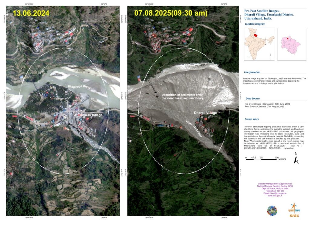
    Assam has become the first Indian State to float a tender for earth observation satellites to monitor floods, borders and environmental threats.

    AssamSAT Project

    • Mission Name: AssamSAT
    • Announced in: Assam Budget 2025-26
    • Issued by: Assam Science Technology and Environment Council
    • Type: Earth observation satellite constellation
    • Orbit: Low Earth Orbit

    Key Features

    • At least five satellites to be deployed
    • Private companies invited to: Design, Build, Launch, Operate and Transfer satellites to State ownership

    Objectives

    1. Flood Monitoring

    • Monitor Brahmaputra valley floods
    • Real time flood mapping
    • Faster disaster response

    2. Surveillance

    • Monitor chars or river islands
    • Track infiltration along Bangladesh border
    • Improve security in remote regions
    • Track: Poaching in Kaziranga National Park, Drug trafficking routes and Land changes
    [2019] For the measurement/estimation of which of the following are satellite images/remote sensing data used? 
    1 Chlorophyll content in the vegetation of a specific location 
    2 Greenhouse gas emissions from rice paddies of a specific location 
    3 Land surface temperatures of a specific location 
    Select the correct answer using the code given below: (a) 1 only (b) 2 and 3 only (c) 3 only (d) 1, 2 and 3
  • FlDepth: New ISRO Tool to Measure Flood Depth from Space

    Why in the News

    Researchers at the National Remote Sensing Centre have developed FlDepth, a new GIS based tool that measures floodwater depth from space in near real time.

    What is FlDepth

    • A satellite based flood depth estimation tool
    • Developed by ISRO National Remote Sensing Centre
    • Converts 2D satellite flood images into 3D flood depth maps
    • Helps in disaster response and flood management
    [2019] For the measurement/estimation of which of the following are satellite images/remote sensing data used? 
    1 Chlorophyll content in the vegetation of a specific location 
    2 Greenhouse gas emissions from rice paddies of a specific location 
    3 Land surface temperatures of a specific location 
    Select the correct answer using the code given below: (a) 1 only (b) 2 and 3 only (c) 3 only (d) 1, 2 and 3
  • NavIC (Navigation with Indian Constellation)

    Why in the News

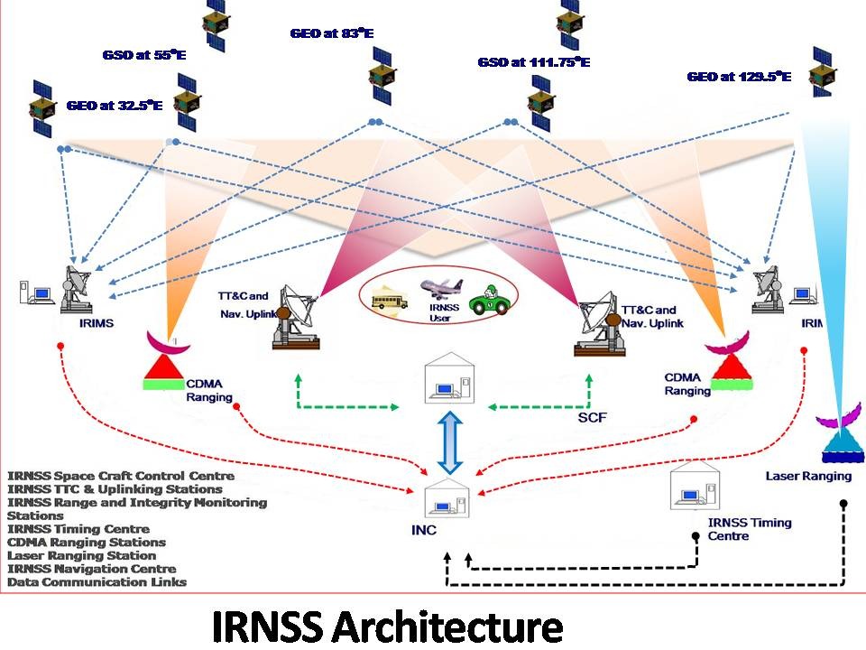
    India’s indigenous navigation system NavIC has been weakened after the failure of the last atomic clock onboard the satellite IRNSS-1F.
    This has reduced the number of fully functional satellites to below the required minimum, affecting navigation accuracy.

    What is NavIC?

    • Developed by ISRO.
    • India’s regional alternative to GPS.
    • Provides Position, Navigation, and Timing (PNT) services.
    • Coverage: India + ~1500 km beyond its borders.

    Role of Atomic Clocks

    • Atomic clocks provide extremely precise time signals.
    • Navigation works by measuring time delay of signals from satellites.
    • Even a tiny error in time → large error in location
    • Hence, clock failure = loss of navigation capability.

    What has happened?

    • The last working atomic clock on IRNSS-1F failed (March 2026).
    • Many earlier NavIC satellites had already lost their clocks.
    • Now:
      • Only 3 satellites are effectively usable
      • Minimum 4 satellites needed for reliable navigation

    Why is this a Concern?

    • Weakens India’s GPS Alternative: NavIC is meant as a strategic backup to systems like GPS (Global Positioning System).
      • Failure reduces self-reliance in critical sectors.
    • Strategic & Security Implications: In conflicts, access to foreign systems may be restricted or denied.
      • Weak NavIC leads to vulnerability in defence navigation.
    • Impact on Civil Applications:
      • Transport and logistics
      • Disaster management
      • Timing systems (banking, telecom)

    Causes of the Problem

    • Heavy reliance on imported atomic clocks (from foreign suppliers).
    • Ageing satellites (many crossed 10-year design life).
    • Earlier multiple clock failures across satellites.

    Steps Taken by India

    • Indigenous Atomic Clocks: New satellites use indigenously developed rubidium atomic clocks. Example: NVS-01
    • Replacement Satellites: ISRO plans to launch at least 3 new satellites by 2026.
    [2018] With reference to the Indian Regional Navigation Satellite System (IRNSS), consider the following statements: IRNSS has three satellites in geostationary and four satellites in geosynchronous orbits. IRNSS covers entire India and about 5500 sq. km beyond its borders. India will have its own satellite navigation system with full global coverage by the middle of 2019. Select the correct answer using the code given below: (a) 1 only (b) 1 and 2 only (c) 2 and 3 only (d) None
  • Starship Delays May Affect NASA’s Moon Landing Timeline

    Why in the News

    A report by NASA’s Inspector General warns that delays in SpaceX Starship could affect the timeline of the Artemis Program, which aims to land humans on the Moon before 2030.

    Background: Artemis Moon Mission

    • NASA is working with private companies like SpaceX and Blue Origin
    • The Artemis programme aims to establish sustainable human missions to the Moon and eventually support missions to Mars.
    • Originally, the Moon landing under Artemis III was targeted for 2024, but delays have pushed the timeline to around 2028 or later.

    Why It Is Difficult

    • Starship uses liquid methane and liquid oxygen as fuel. These must be stored at cryogenic temperatures below −150°C.
    • The system must perform multiple docking and fuel transfers in Low Earth Orbit (LEO).
    • LEO already has heavy satellite traffic, increasing operational risk.
    [2011] An artificial satellite orbiting around the Earth does not fall down. This is so because the attraction of Earth (a) does not exist at such a distance. (b) is neutralized by the attraction of the moon. (c) provides the necessary speed for its steady motion. (d) provides the necessary acceleration for its motion.
  • BEL–Bellatrix Partnership to Develop VLEO Satellite Systems

    Why in the News

    India’s defence PSU Bharat Electronics Limited (BEL) and space-tech startup Bellatrix Aerospace have signed an MoU to jointly develop Very Low Earth Orbit (VLEO) satellite systems.

    What is VLEO (Very Low Earth Orbit)?

    • Altitude: About 150 km to 450 km above Earth.
    • Lower than Low Earth Orbit (LEO) satellites.
    • Satellites experience thin atmospheric drag, requiring propulsion systems to maintain orbit.

    How VLEO Satellites Work

    • At low altitude, satellites face aerodynamic drag from the upper atmosphere.
    • Advanced propulsion systems provide continuous thrust to maintain orbital position.
    • Bellatrix will use electric/green propulsion technologies for station-keeping.

    Key Features of VLEO Systems

    • High-Resolution Imaging: Closer proximity to Earth enables sub-meter imaging using smaller sensors.
    • Ultra-Low Latency Communication: Shorter signal distance enables faster data transmission and real-time communication.
    • Lower Launch Costs: Lower orbit requires less fuel to deploy satellites.
    • Reduced Space Debris: Failed satellites naturally re-enter and burn up due to atmospheric drag.

    Aim of the Partnership

    • Develop indigenous VLEO satellite platforms and payloads.
    • Provide solutions for defence and civilian applications.
    • Combine PSU manufacturing capability with startup innovation.

    Strategic Significance

    • Strengthens India’s self-reliance in space technology.
    • Enables high-resolution surveillance and intelligence gathering.
    • Useful for:
      • Border monitoring
      • Earth observation
      • Real-time communication systems.

    Prelims Pointers

    • Bharat Electronics Limited (BEL) operates under the Ministry of Defence.
    • Bellatrix Aerospace develops satellite propulsion systems.
    • VLEO satellites orbit at lower altitude than conventional Earth-observation satellites, offering improved imaging and reduced debris risk.
    [2011] An artificial satellite orbiting around the Earth does not fall down. This is so because the attraction of Earth (a) does not exist at such a distance. (b) is neutralized by the attraction of the moon. (c) provides the necessary speed for its steady motion. (d) provides the necessary acceleration for its motion

  • How do astronauts return from space and survive re-entry

    Why in the News?

    India is advancing its human spaceflight ambitions under ISRO’s Gaganyaan programme, with successful Crew Escape System tests and re-entry validation experiments demonstrating safe atmospheric descent capability. Since re-entry involves extreme heat (over 1,500°C) and velocities exceeding 25,000 km/h, mastering this phase is a critical milestone that places India closer to joining the limited group of nations capable of independently returning astronauts safely from space.

    What is spacecraft re-entry?

    Spacecraft re-entry is the critical process of a vehicle returning from space, passing through a planet’s atmosphere to land on the surface. It is a controlled deceleration process in which a spacecraft transitions from orbital velocity to safe landing conditions.It involves using atmospheric drag and heat shielding to dissipate immense kinetic energy (approx. mph) while managing temperatures up to caused by compressed air.

    Key aspects of re-entry include:

    1. Deceleration and Heating: As the spacecraft hits the dense atmosphere, it experiences extreme deceleration and intense heat, often creating a “wall of fire” around the craft.
    2. Thermal Protection: Vehicles use specialized heat shields, such as ablative materials, to protect against temperatures exceeding 1650 degree celsius.
    3. Methods: Re-entry can be controlled (using engines for precise, safe, or targeted landing) or uncontrolled (naturally falling back).
    4. Phases: It typically involves deorbiting, atmospheric entry, and landing (often using parachutes).
    5. Challenges: The “entry corridor” must be precisely navigated; entering too steeply causes excessive heat, while too shallow causes the craft to skip back into space

    Why is Re-entry Considered the Most Critical Phase of Spaceflight?

    1. Orbital Velocity: Spacecraft travel at ~7.8 km/s in Low Earth Orbit, generating extreme kinetic energy during descent.
    2. Thermal Load: Atmospheric compression produces temperatures above 1,500°C, sufficient to melt structural metals.
    3. Deceleration Stress: Astronauts experience high G-forces due to rapid velocity reduction.
    4. Historical Precedent: Early scientific belief held that re-entry survival was impossible due to predicted structural failure from heat loads.

    How Does a Spacecraft Dissipate Immense Heat During Re-entry?

    1. Blunt Body Design: Rounded capsule structure disperses heat around the vehicle rather than allowing penetration.
    2. Aerodynamic Braking (Aerobraking): Uses atmospheric drag to systematically reduce speed without propulsion fuel.
    3. Thermal Protection System (TPS): Shields internal structure from heat exposure.
    4. Ablation Mechanism: Outer material chars and erodes, carrying heat away from the capsule.
    5. Heat Shield Materials: Designed to prevent thermal transfer to primary structure and crew module.

    What is the “Re-entry Corridor” and Why is It Crucial?

    1. Optimal Angle Window: Ensures safe atmospheric penetration between overshoot and undershoot limits.
    2. Overshoot Risk: Too shallow angle causes the capsule to skip back into space.
    3. Undershoot Risk: Too steep angle results in excessive heating and structural stress.
    4. Precision Navigation: Onboard guidance systems adjust trajectory within strict tolerances.

    Why Does Communication Blackout Occur During Re-entry?

    1. Plasma Formation: Extreme heat ionizes surrounding air, forming an electrically charged plasma layer.
    2. Signal Obstruction: Plasma sheath blocks radio communication between crew and ground stations.
    3. Blackout Duration: Persists until velocity reduces sufficiently for plasma dissipation.
    4. Mitigation Strategy: Use of relay satellites and high-frequency transmission pathways through thinner plasma regions.

    How Do Parachutes Enable Safe Landing?

    1. Terminal Velocity Reduction: Atmospheric drag alone remains insufficient for safe splashdown.
    2. Multi-stage Deployment: Drogue parachutes stabilize descent; main parachutes reduce final speed.
    3. Controlled Splashdown: Ensures low-impact landing in designated sea recovery zones.
    4. Landing Example: Bay of Bengal identified as primary splashdown zone for Indian missions.

    How Will India’s Gaganyaan Crew Module Execute Re-entry?

    1. Crew Module (CM): Maintains trajectory within re-entry corridor and survives thermal stress.
    2. Service Module (SM): Provides propulsion during orbital phase; separates before re-entry.
    3. Controlled Manoeuvres: Adjusts lift-to-drag ratio for precise landing.
    4. Thermal Validation: Crew Module Atmospheric Re-entry Experiment validated full-scale heat shield.
    5. Operational Significance: Positions India among nations capable of independent human re-entry systems.

    Conclusion

    Safe atmospheric re-entry represents the ultimate test of a nation’s human spaceflight capability, demanding mastery over thermal protection, trajectory precision, communication resilience, and controlled descent systems. As India advances toward operationalizing Gaganyaan, successful re-entry validation will not only ensure astronaut safety but also strengthen technological sovereignty, strategic autonomy, and India’s position among leading spacefaring nations.

    PYQ Relevance

    [UPSC 2017] India has achieved remarkable successes in unmanned space missions including the Chandrayaan and Mars Orbiter Mission, but has not ventured into manned space mission. What are the main obstacles to launching a manned space mission, both in terms of technology and logistics? Examine critically.

    Linkage: This GS-3 question examines the technological and logistical challenges in shifting from unmanned missions to human spaceflight. It directly links to Gaganyaan, especially re-entry systems, crew safety, and human-rated launch capability.