UPSC 2022 countdown has begun! Get your personal guidance plan now! (Click here)
01 Sept 2021
Major Rivers in India
Indus River System
| Indus | Ancient name → Sindhu Origin → Bokharchu Glacier, Near Mansarovar In Tibet, Called Singi Khamban / Lion’s mouth Enters In India through Ladakh, flows only in J &K Enters Pak through hairpin bend of Nanga Parbat Finally Discharges in Arabian Sea Flows approx. ( 709 / 2880 ) Km in India India uses 20 % of its water by Indo Pak water treaty of 1960 |
| Shyok | Originates from Rimo Glacier Known as river of death flows through Ladakh in India A tributary of the Indus River |
| Jhelum | Ancient name → Vitasta Origin → Verinag Spring (Kashmir) Tributary of Indus flows only in J &K Flows Northward to Wular Lake Cut through the gorge in Pir- Panjal range to reach Muzzafarabad (POK) |

| Chenab | Ancient name → Akshani / Iskmati Origin → Bara Lacha Pass (Himachal) Known as chandra-bhaga in Himachal Chandra River → Water flowing south from the pass Bhaga River → Water Flowing north from the pass Flows Northward & parallel to Pir –Panjal Range for some distance Cut through gorge in Pir – Panjal & Turns southward Largest tributary of Indus, Flows through Himachal & J & K Famous Projects → Duhasti, Baglihar & Salal hydroelectric project |
| Ravi | Ancient name → Purushni Origin → Kullu hills near Rohtang Pass (Himachal) Tributary of Chenab Smallest of 5 rivers Flows through Indo – Pak boundary Flows northward b/w Pir – Panjal & Dhauladhar Ranges Cut a gorge through Dhauladhar range & flows southward |
| Beas | Ancient name → Vipasha Origin → Beas kund near Rohtang Pass, Himachal Tributary of Satluj Only river flowing entirely in India Runs southward, Cut a deep gorge in Dhauladhar & turns west to meet Satluj near Harike (Punjab) Famous Project → Pong Dam |
| Sutluj | Ancient name → Shatadru Origin → Rakas lake, Tibet, near Mansarovar Enter Himachal at Shipki La Pass Collects water from Ravi, Chenab, Jhelum & Beas to join Indus near Mithalkot (Pak) Famous Projects → Naptha Jhakri Project & Bhakra Nagal Dam with Govind Sagar Reservoir |
Ganga River System
- Origin → As Bhagirathi from Gangotri Glacier (Uttarkashi – Uttarakhand)
- Alakananda unites with Bhagirathi at Devprayag, Uttarakhand → Henceforth known as Ganga
- Passing through Rishikesh, it debounches in plains of Haridwar
- From Haridwar, it flows Southward to reach Allahabad where it joins the Yamuna
- Near Rajmahal Hills, it turns southeast & bifurcate at Farraka into Hoogly (Kolkata) & Padma (BD)
- At Bangladesh, Ganga merges with Brahmputra (Known as Jamuna in Bangladesh) at Goalundo Ghats
- Mixture is known as Padma River
- Then it merges with Meghna & finally falls in the Bay of Bengal
- Meghna → Known as Barack river in India
- Major tributaries → Yamuna, Gomti, Ghaghara, Gandak, Kosi, Son & Punpun

| Ghaghara | Origin → Bharchachungar Glacier (Rakas lake) near Mansarovar Joins Ganga at Chhapr. Known as Manchu or Karnali in Nepal. Known as Saryu or Ghaghra in UP Perennial river Major tributaries → Sarda & Rakti |
| Gandak | Origin → Sino – Nepal Boundary (Dhaulagiri range) Known as Kalyani in Nepal Major River of Nepal Joins Ganga at Sonpur, Bihar |
| Kosi | Origin → Gosainath peak (Tibet) Merges with river Ganga at Bhagalpur (Bihar) Consists of 7 streams & known as Saptakoshi in Nepal Main stream → Arun, Tamur & Sun Koshi Formerly Known as Sorrow of Bihar Major Projects → Kusha Dam |
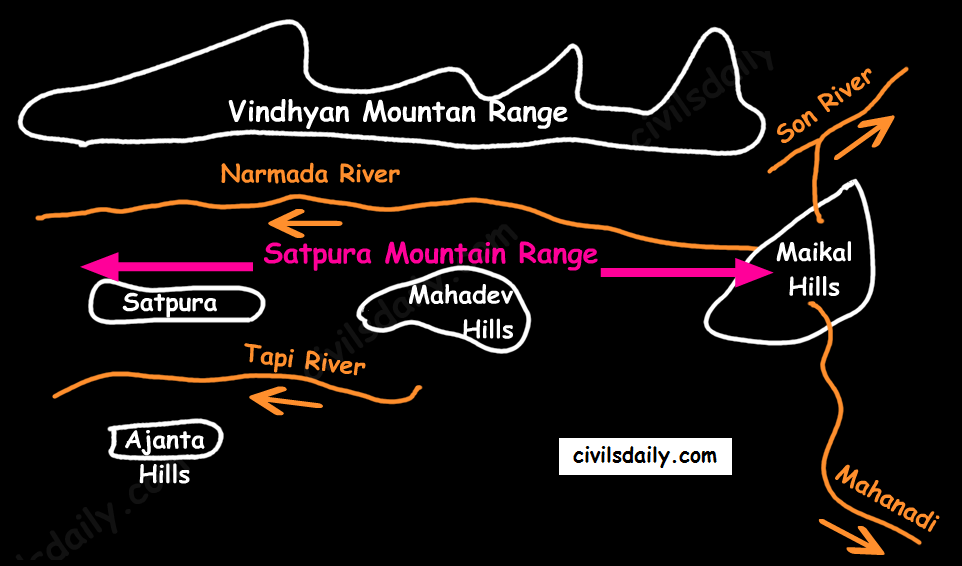
| Son | Origin → Amarkantak Plateau (Near north of origin of Narmada) Flows through Kaimur Range to meet Ganga at Patna |
| Gomti | Originates from Gomat Taal / Fulhaar jheel – Pilibhit A tributary of Ganga |
| Yamuna | Origin → Yamunotri Glacier (Uttarkashi – Uttarakhand) Largest Tributary of Ganga After cutting deep gorge across Shivalik, it enters into plains near Tajewala Flows southward up to Agra & then turns southeast to meet Ganga at Allahabad Famous tributaries → Chambal, Sind, Betwa & Ken |
| Betwa | Major Tributaries → Tributary of Yamuna, rises from Vindhya range, MP Major Projects → Matatila dam & Rajghat dam |
| Ken | Rises from Kaimur hills in Satna (Madhya Pradesh), a tributary of Yamuna Famous for its Shajar stone & Raneh waterfalls |
| Chambal | Origin → Vindhya Range (Mhow, MP) Passes through Kota & Dhaulpur (Rajasthan) Merge with Yamuna at Etawah (UP) forms boundary between Rajasthan & MP Major tributaries → Kali Sindh, Parvati & Banas Main Power Projects → Gandhisagar, Rana Pratap Sagar & Jawahar Sagar |
| Banas | Originate from eastern slopes of Aravali Tributary of Chambal |
| Damodar | Origin → Eastern part of Chhota Nagpur Plateu Meets Hoogli at Falta Power Projects → Talaiya, Maithan, Barakar & Panchet |
Brahmaputra River System
- Origin → Chemayungdung Glacier (Kailash Range, Tibet)
- In Tibet, known as TSANG – PO
- In China, known as YARLUNG ZANBO
- Forms grand canyon in Tibet
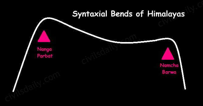
- Turns southward near Namcha – Barwa
- Enters Arunachal Pradesh as Dihang River at Sadiya, emerging from the mountains
- Joined by Dibang river from the north & Lohit river from the south → Known as Brahamputra
- Turns at Dhubri to enter into Bangladesh
- After joining Teesta, known as Jamuna in BD
- Joins Ganga & Megna → Merges to BOB.
- Forms many river island of which Majuli is world 2nd largest one
- Major tributaries → Dihang, Lohit, Subansiri, Teesta, Meghna (Barack in Assam), Manas
| Teesta | Major tributary of Brahmaputra Rises from Sikkim Known as lifeline of Sikkim |
| Lohit | Tributary of Brahmaputra Flows through Arunachal Pradesh Along with river, Dihang merges into Brahmaputra, at Sadia town (Arunachal Pradesh) |
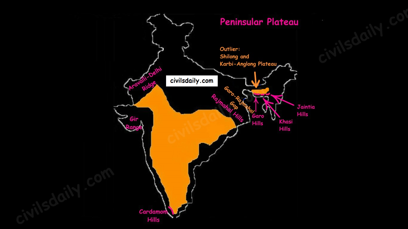
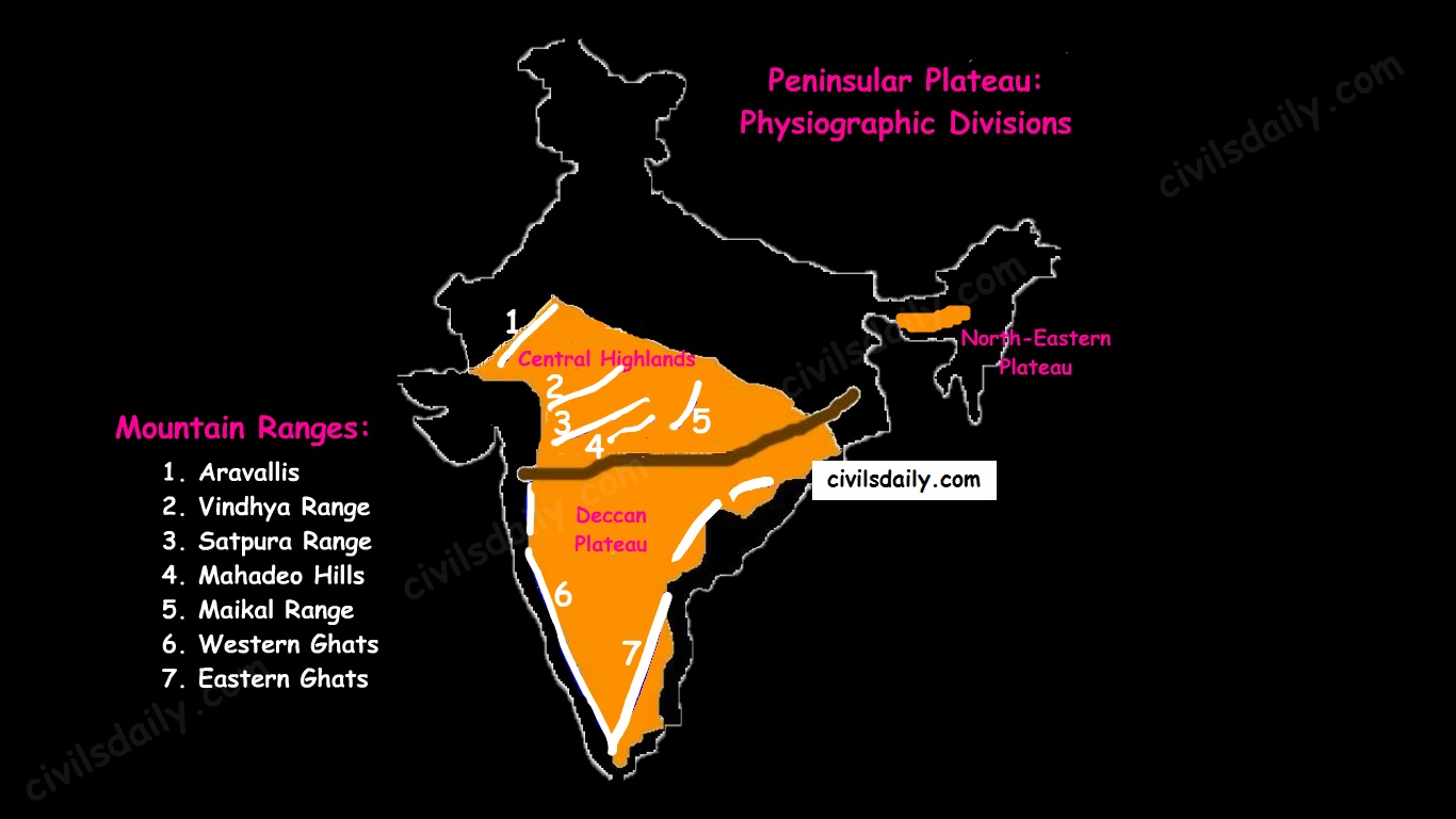
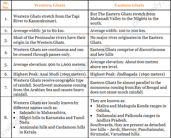
Peninsular Rivers India – Flowing East to West
| Luni | Desertic river, also known as the Sagarmati Rises from the western slopes of the Aravalli Range near Ajmer Ends in the marshy lands of Rann of Kutch in Gujarat Inspite of high salinity, it is a major river in region Serves as a primary source of irrigation |
| Sabarmati | Rises from Dhebar lake in Aravalli Range of the Udaipur (Rajasthan) Flow Route: Udaipur → Gulf of Khambat → Arabian Sea via Estuary |
| Mahi | Rises from Vindhya range (MP) flows through MP, Rajasthan & Gujrat & drains in Gulf of Cambay Famous Projects → Banswara Dam & Kadana dam |

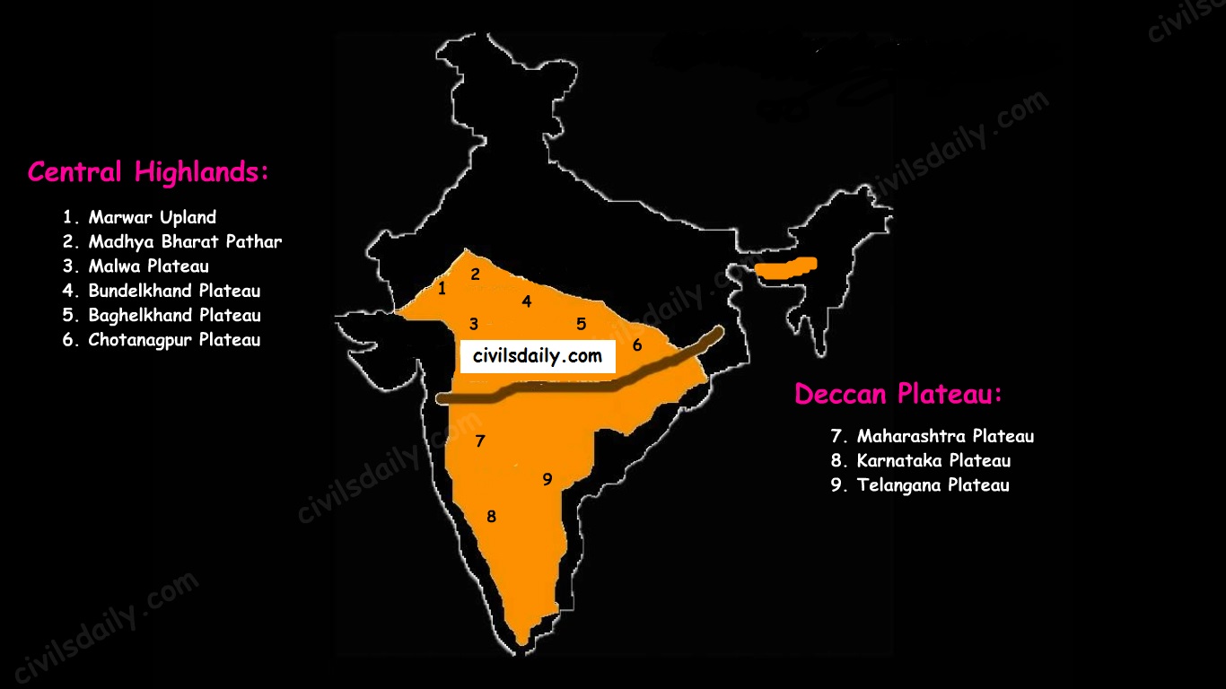
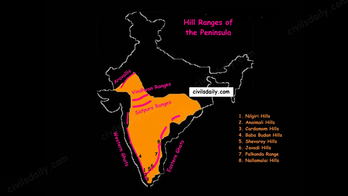
| Narmada | Origin → Amarkantak, Shahdol, MP Also known as Rewa River Flows through rift valley of Vindhya & Satpura Flow Route: MP → Bharuch (Gujrat) → Gulf of Khambat (Gujrat) → Arabian Sea via Estuary Longest among all east to west flowing rivers Known as Life line of MP Forms Duandhar falls at Jabalpur Only tributary → Hiran River Aliabet → Largest Island in Estuary Famous projects →Sardar Sarovar Dam, Maheshwar Dam, Indira Gandhi Sagar Dam |
| Tawa | Rises in the Satpura Range of Betul (MP) Narmada’s longest tributary |
| Tapi | Origin → Mahadev hills, Satpura range, Betul district, MP Flow Route: MP → Maharashtra → Gulf of Khambat or Cambay → Arabian Sea via Estuary Famous projects → Kakrapar Dam & Ukai Dam |
| Periyar | Rises from Western Ghats in Kerala Flows towards west & drains in Arabian Sea via an estuary |
Peninsular Rivers India – Flowing West to East
| Mahanadi | Origin → Dandakaranya Hills, Raipur Flow Route: Chhattisgarh → Orissa → EGs → BOB Famous Project : Hirakund Dam |
| Godavari | Origin → Triambakeshwar Plateau, Nashik, WGs Largest Peninsular River Known as Dakshina / Vriddha Ganga Flow Route: Nashik → Andhra Pradesh → BOB Famous Tributaries → Penganga, Sabri, Wardha & Indravati Famous Projects → Poochampad, Jayakwadi, Polavaram |
| Penganga | Rises from Ajanta hills (Maharashtra) a tributary of River Wardha which finally merges into Godavari |

| Krishna | Origin → Mahabaleshwar, Maharashtra, WGs Flow Route: Maharashtra → Andhra Pradesh → BOB Famous Projects → Koyna, Tugrabhdra, Srisailam & Nagarjuna Sagar Dam |
| Tungabhadra | a major tributary of Krishna Rises from Western Ghats |
| Bhima | Rises from Balaghat range (Maharashtra) Tributary of Krishna |
| Kaveri | Origin → Brahamgiri hills, Karnataka, WGs Flow Route: Karnataka → Kaveripatnam (TN) →BOB Perrenial River Forms Shivasundaram Waterfalls Famous projects → Krishnaraja Sagar & Mettur |
| Penner | Rises from Karnataka Flows b/w Krishna & Kaveri Drains into BOB |
| Vaigai | Rises from Palni hills (TN) A seasonal river flows through TN Drains in Gulf of Mannar |
Important Rivers of the World
| Sr. No. | RIVER | LOCATION | DESCRIPTION |
| 1. | River Amazon | South America | It is the second longest river which flows through Peru, Columbia, Brazil and drains into the Atlantic Ocean. |
| 2. | River Mississippi | North America | It forms a bird-foot like a delta at the Gulf of Mexico, River Missouri is an important tributary of it. |
| 3. | River St. Lawrence | North America | It drains into Gulf of St. Lawrence which is an important transport corridor of North America. |
| 4. | River Orange | South Africa | Longest river of South Africa and contains diamond beds along its mouth. |
| 5. | River Congo | Africa | This river crosses the equator twice and drains into the south Atlantic Ocean. |
| 6. | River Nile | Africa | It is the longest river in the world, originates near Lake Victoria and drains in the Mediterranean Sea. |
| 7. | River Rhine | Western Europe | It flows through Germany and Netherlands. It is one of the busiest waterways of Europe. |
| 8. | River Danube | Europe | It passes through Germany, Hungary, Austria, Slovakia, Serbia, Romania and drains into the Black Sea. |
| 9. | River Volga | Europe, Russia | It is the longest river in Europe, it drains into the Caspian Sea. |
| 10. | River Tigris | Turkey, Iraq | Cities like Mosul, Baghdad, Basra were located along its banks and it drains into the Gulf of Persia. |
| 11. | River Euphrates | Turkey, Syria, Iraq | Main source of water for Syria. It drains into the Persian Gulf. |
| 12. | River Irrawaddy | Myanmar | Drains into Gulf of Martaban |
| 13. | River Mekong | China, Laos, Cambodia, Vietnam | It is also called ‘Danube of the east’, and it merges with south china sea. |
| 14. | River Yangtze | China | It originates from the Tibetan plateau and ends in east china sea. It is the longest river in China. |
Important Lakes of the World
| Sr. No. | NAME | LOCATION | FACTS |
| 1. | Titicaca lake | South America | It is the highest navigable lake in the world located in the Andes mountains. |
| 2. | Great bear lake | Canada, North America | It is a big glaciated lake in Canada. The Eskimos of Canada camp here during the summer season. |
| 3. | Great lakes | North America | This comprises of five large lakes of North America such as Lake Superior, Michigan, Huron, Erie, Ontario. Lake Superior is the second largest lake in the world. |
| 4. | Lake Malawi | Central Africa | It is the third-largest lake of Africa and borders Tanzania, Mozambique. |
| 5. | Lake Tanganyika | East Africa | It is the deepest and second largest lake of Africa. |
| 6. | Lake Victoria | Africa | The largest river of Africa and passes through the equator. |
| 7. | Lake Kainji | Africa | Largest manmade lake of Africa, used for irrigation purposes. |
| 8. | Dead sea | West Asia | It is bordered by Jordan in the east and Palestine, Israel in the west. It is known for its high salinity. |
| 9. | Aral Sea | Central Asia | Located between Uzbekistan and Kazakhstan. It is shrinking rapidly in recent years. |
| 10. | Lake Baikal | Russia | It is the largest freshwater lake in Asia and the deepest in the world. |
| 11. | Caspian Sea | Eurasia | It is the largest lake in the world and is surrounded by Russia, Kazakhstan, Turkmenistan, Iran, and Azerbaijan. |
Important Mountain Ranges and Peaks of the Worlds
| Sr. No. | Mountain Range | Important/Highest Peaks | Location | Description |
| 1. | Rocky Mountains | Mt. Elbert (highest peak in the Rockies) | North America | It is one of the longest fold mountains in the world and extends from Canada to the Western US (New Mexico State). |
| 2. | Appalachian Mountains | Mt. Mitchell, North Carolina, US (highest peak of Appalachian Mountains) | North America | It is a fold mountain rich in mineral resources. |
| 3. | Alps | Mont Blanc (French –Italian border) | Europe | It is a folded mountain and source for rivers like Danube, Rhine, etc. |
| 4. | Sierra Nevada | Mt. Whitney | California, USA | Habitat for many Red Indian tribes |
| 5. | Alaska Range | Mt. McKinley | North America | Mt. McKinley highest peak in North America |
| 6. | Altai Mountains | Belukha mountain | Central Asia | Young folded mountain which extends from Kazakhstan to northern China. |
| 7. | Andes Mountains | Mt. Aconcagua | South America | Longest mountain chain in the world |
| 8. | Atlas Mountains | Mt. Toubkal | Northwestern Africa | Young fold mountain spreading over Morocco and Tunisia. |
| 9. | Drakensberg Mountains | Mt. Lesotho | South Africa | Young folded mountain |
| 10. | Caucasus Mountain | Mt. Elbrus | Europe | Located between the Black Sea and the Caspian Sea |
| 11. | Ural Mountains | Mt. Narodnaya | Russia | This mountain range act as a boundary between Europe and Asia. |
| 12. | Hindukush Mountains | Mt. Trich Mir | Pakistan and Afghanistan | Folded mountain with rugged topography which makes it difficult for transportation. |
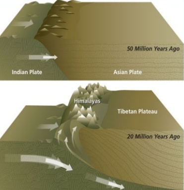
| 13. | Himalayas | Mt. Everest | Asia | Young fold mountains in Asia which separate Indian sub-continent from the Asian plains |
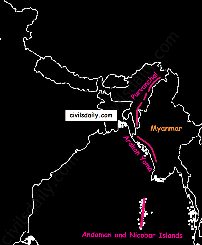
| 14. | Arakan Yoma | Mt. Kennedy peak | Myanmar | It extends from north to south direction. Shifting cultivation is practised. |
| 15. | Kunlun Mountains | Mt. Muztag | North of Tibetan plateau and western China | It is one of the young folded mountains. |
| 16. | Vosges | Mt. Grand Ballon | Eastern France, Europe | Famous for the cultivation of grapes and manufacture of wines. |
| 17. | Great Dividing Range | Mt. Kosciuszko | Australia | This range is the source for the rivers Darling and Murray. |
UPSC 2022 countdown has begun! Get your personal guidance plan now! (Click here)
Samanvaya: Free 1-to-1 mentorship for UPSC IAS
Fill up this form to schedule a free on-call discussion with senior mentor from Civilsdaily. Once submitted we will call you within 24 hours.


#/media/File:Dolina_Jaworzynki_a1.jpg)