💥Join UPSC 2027,2028 Mentorship (August Batch) + XFactor Notes & Microthemes PDF

GS Paper: GS1

  • Explained: Marine Heatwave (MHW)


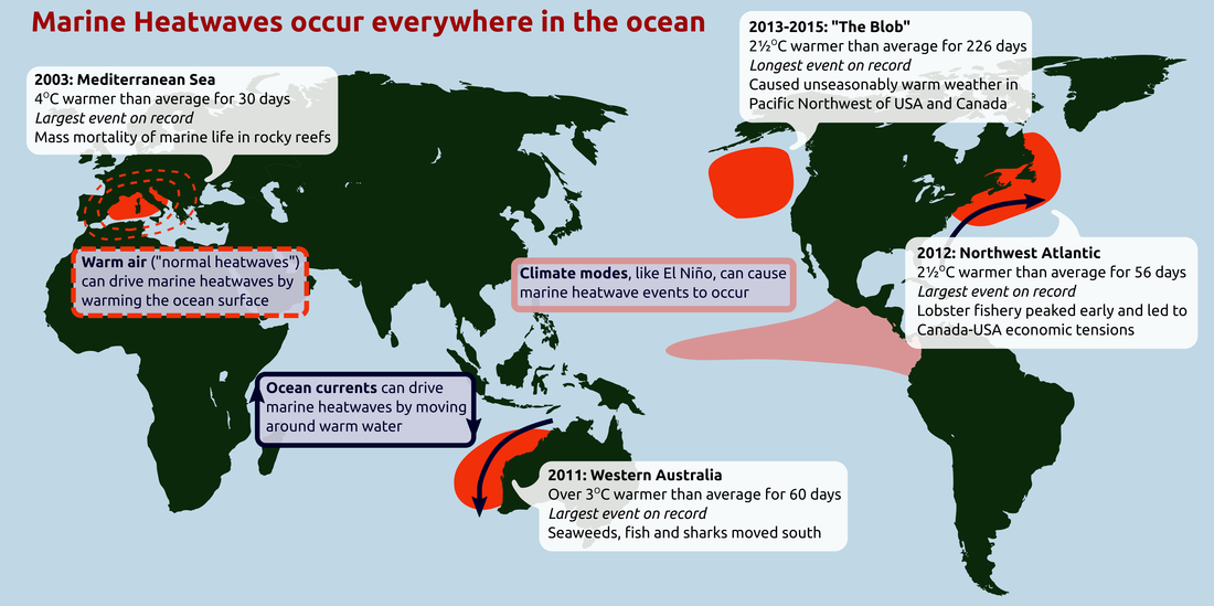
    Scientists have observed unusually high sea surface temperatures (SSTs) in the Pacific Ocean around the western coast of the United States.  This marine heatwave (MHW), covering an area of roughly 6.5 million square kilometres, can affect marine life and lead to droughts in the surrounding regions.

    What are MHWs?

    • We know that heatwaves occur in the atmosphere. We are all familiar with these extended periods of excessively hot weather.
    • However, heatwaves can also occur in the ocean and these are known as marine heatwaves, or MHWs.
    • These marine heatwaves, when ocean temperatures are extremely warm for an extended period of time can have significant impacts on marine ecosystems and industries.

    When do they occur?

    • Heatwaves can happen in summer and also in winter, where they are known as “winter warm-spells”.
    • These winter events can have important impacts, such as in the southeast of Australia where the spiny sea urchin can only colonize further south when winter temperatures are above 12 °C.

    What causes marine heatwaves?

    • Marine heatwaves can be caused by a whole range of factors, and not all factors are important for each event.
    • The most common drivers of marine heatwaves include ocean currents which can build up areas of warm water and air-sea heat flux, or warming through the ocean surface from the atmosphere.
    • Winds can enhance or suppress the warming in a marine heatwave, and climate modes like El Niño can change the likelihood of events occurring in certain regions.
    • MHWs can be caused due to large-scale drivers of the Earth’s climate like the El Niño Southern Oscillation (ENSO).

    Impacts of the MHWs

    • Marine heatwaves affect ecosystem structure, by supporting certain species and suppressing others.
    • For example, after the 2011 marine heatwave in Western Australia the fish communities had a much more “tropical” nature than previously and switched from kelp forests to seaweed turfs.
    • Marine heatwaves can cause economic losses through impacts on fisheries and aquaculture.
    • Temperature-sensitive species such as corals are especially vulnerable to MHWs. In 2016, marine heatwaves across northern Australia led to severe bleaching of the Great Barrier Reef.

    How do we measure marine heatwaves?
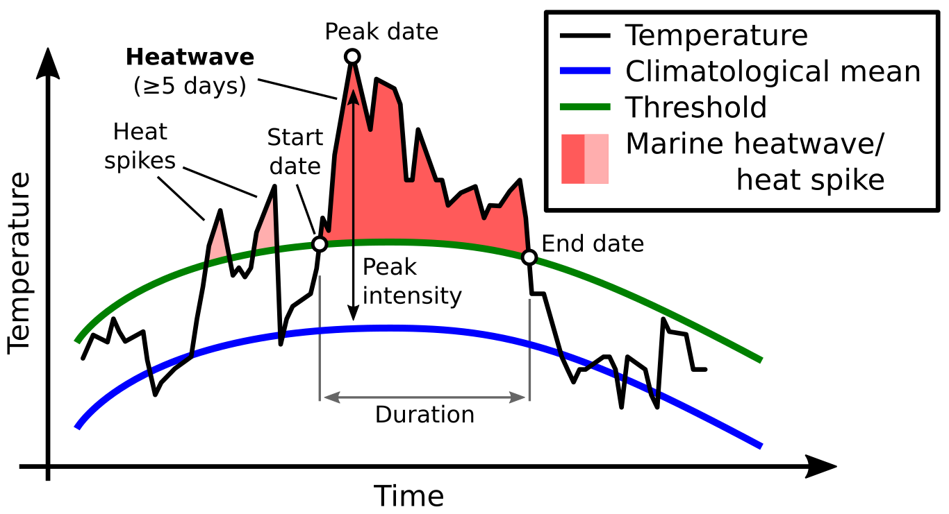
    • A marine heatwave occurs when seawater temperatures exceed a seasonally-varying threshold (usually the 90th percentile) for at least 5 consecutive days.
    • Successive heatwaves with gaps of 2 days or less are considered part of the same event.

    Why study MHWs?

    • MHWs are increasing in frequency due to climate change. MHWs increased by 54 per cent in the last 30 years.
    • Despite their potential impact on the health of marine ecosystems, MHWs remain one of the least studied consequences of global warming.

    Way Forward

    • Marine heatwaves clearly have the potential to devastate marine ecosystems and cause economic losses in fisheries, aquaculture, and ecotourism industries.
    • However, their effects are often hidden from view under the waves until it is too late.
    • By raising general awareness of these phenomena, and by improving our scientific understanding of their physical properties and ecological impacts, we can better predict future conditions and protect vulnerable marine habitats and resources.
  • Red Snow in Antarctica


    Over the last few weeks, photographs of “red snow” off the coast of Antarctica’s northernmost peninsula, have gone viral. “Red snow” or “watermelon” is a phenomenon that has been known since ancient times. Now, it raises concerns about climate change.

    Red snow in Antarctica: Why it happens 

    • Aristotle is believed to be one of the first to give a written account of red snow, over 2,000 years ago.
    • What Aristotle described as worms and grub, the scientific world today calls algae.
    • This alga species, Chlamydomonas Chlamydomonas nivalis, exists in the snow in the polar and glacial regions and carries a red pigment to keep itself warm.

    Signs of faster melting 

    • In turn, the red snow causes the surrounding ice to melt faster. The more the algae packed together, the redder the snow.
    • And the darker the tinge, the more the heat absorbed by the snow. Subsequently, the ice melts faster.
    • While the melt is good for the microbes that need the liquid water to survive and thrive, it’s bad for glaciers that are already melting from a myriad of other causes, the study said.
    • These algae change the snow’s albedo — which refers to the amount of light or radiation the snow surface is able to reflect back. Changes in albedo lead to more melting.
  • [pib] Indian National Centre for Ocean Information Services (INCOIS)


    The INCOIS Hyderabad has launched a trio of products for users in the marine realm.

    About INCOIS

    • The institute is an autonomous organisation under the Ministry of Earth Sciences.
    • INCOIS prioritises requests for specific services from its diverse user community that ranges right from fishermen to offshore oil exploration industries.

    Products launched:

    Small Vessel Advisory and Forecast Services System (SVAS)  

    The SVAS is an innovative impact-based advisory and forecast service system for small vessels operating in Indian coastal waters.

    • The SVA system warns users about potential zones where vessel overturning can take place, ten days in advance.
    • The advisories are valid for small vessels of beam width up to 7 m.
    • This limit covers the entire range of beam widths of the fishing vessels used in all the 9 coastal states and union territories of India.
    • The warning system is based on the  ‘Boat Safety Index’ (BSI) derived from wave model forecast outputs such as significant wave height, wave steepness, directional spread and the rapid development of wind at sea which is boat-specific.

    Swell Surge Forecast System (SSFS)

    SSFS is an innovative system designed for the prediction of Kallakkadal/Swell Surge that occurs along the Indian coast, particularly the west coast.

    • Kallakadal/Swell surge are flash-flood events that take place without any noticeable advance change in local winds or any other apparent signature in the coastal environment.
    • Hence the local population remains totally unaware of these flooding events until they actually occur. Such events are intermittent throughout the year.
    • Kallakkadal is a colloquial term used by Kerala fishermen to refer to the freaky flooding episodes and in 2012 UNESCO formally accepted this term for scientific use.
    • Kallakkadal are caused by meteorological conditions in the Southern Ocean, south of 30°S.
    • These swells once generated, travel northward and reach the Indian coasts in 3-5 days time, creating havoc in the coastal areas.
    • The system will now predict Kallakkadal and warnings will be given to concerned authorities at least 2-3 days in advance, which will help the local authorities for contingency plans and to reduce damage.

    Algal Bloom Information Service (ABIS)

    • The increasing frequency of algal blooms is a major concern due to its ill effects on the fishery, marine life and water quality.
    • INCOIS has developed a service for “Detection and Monitoring of Bloom in the Indian Seas”.
    • The target users are fishermen, marine fishery resource managers, researchers, ecologists and environmentalists.
    • The service also complements INCOIS’ marine fishing advisories i.e. Potential Fishing Zone advisories.
    • INCOIS-ABIS will provide near-real-time information on spatio-temporal occurrence and spread of phytoplankton blooms over the North Indian Ocean.
    • In addition, four regions have been identified as bloom hotspots viz.

    a) North Eastern Arabian Sea

    b) coastal waters off Kerala

    c) Gulf of Mannar and

    d) coastal waters of Gopalpur

  • Solar Storms


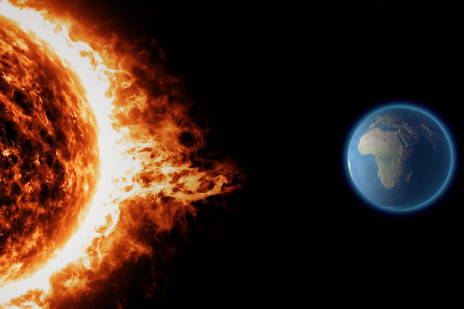
    According to a research, sudden releases of high-energy particles from the sun, called solar storms, can mess with the navigational ability of gray whales, causing them to strand on land.

    Solar storms

    • Solar storms are a variety of eruptions of mass and energy from the solar surface.
    • Flares, prominences, sunspots, coronal mass ejections are the common harbingers of solar activity, as are plages and other related phenomena seen at other wavelengths.

    Impact on Whales

    • Solar storms have the potential to modify geomagnetic field and disrupt magnetic orientation behaviour of animals, hampering their navigation during long periods of migration.
    • They disrupt earth’s magnetic field — and the whales’ navigational sense.
    • The radio frequency noise created by the solar outburst affects the whales’ senses in a way that prevents them from navigating at all.
  • Yongle Blue Hole (YBH)


    Carbon more than 8,000 years old has been found inside the world’s deepest blue hole — the Yongle Blue Hole (YBH).

    Yongle Blue Hole (YBH)

    • The deepest known marine cavern is the Yongle blue hole, which measures roughly 300 metres from top to bottom.
    • Blue holes are marine caverns filled with water and are formed following dissolution of carbonate rocks, usually under the influence of global sea level rise or fall.
    • Its waters are mostly isolated from the surrounding ocean and receive little fresh water from rainfall, making it a rare spot to study the chemistry of oxygen-deprived marine ecosystems.
    • What distinguishes them from other aquatic caverns is that they are isolated from the ocean and don’t receive fresh rainwater.
    • They are generally circular, steep-walled and open to surface.

    Significance of YBH

    • YBH has a depth of 300 metres, far deeper than the previously recorded deepest blue hole, Dean’s Blue Hole in Bahamas, which had a depth of 202 metres.
    • However, like most blue holes, it is anoxic i.e. depleted of dissolved oxygen below a certain depth. This anaerobic environment is unfavorable for most sea life.
    • Such anoxic ecosystems are considered a critical environmental and ecological issue as they have led to several mass extinctions.
    • Concentrations of carbon, usually found in deep marine holes like YBH, provide a natural laboratory to study carbon cycling and potential mechanisms controlling it in the marine ecosystem.
    • The transition from aerobic to anaerobic environment adversely affects the biogeo-chemistry of the ocean.
  • Taj Mahal Complex

    The Taj Mahal complex has been spruced up for the visit of US President Donald Trump and First Lady Melania Trump.

    About Taj

    • The Taj Mahal is an ivory-white marble mausoleum on the south bank of the Yamuna river in the city of Agra.
    • It was commissioned in 1632 by Shah Jahan (reigned from 1628 to 1658) to house the tomb of his favourite wife, Mumtaz Mahal; it also houses the tomb of Shah Jahan himself.
    • The tomb is the centrepiece of a 17-hectare (42-acre) complex, which includes a mosque and a guest house, and is set in formal gardens bounded on three sides by a crenellated wall.
    • The Taj Mahal complex is believed to have been completed in its entirety in 1653 at a cost estimated at the time to be around 32 million rupees, which in 2015 would be approximately 52.8 billion rupees (U.S. $827 million).
    • The construction project employed some 20,000 artisans under the guidance of a board of architects led by the court architect to the emperor, Ustad Ahmad Lahauri.
    • The Taj Mahal was designated as a UNESCO World Heritage Site in 1983 for being “the jewel of Muslim art in India and one of the universally admired masterpieces of the world’s heritage”.

    Various threats to Taj

    • The Supreme Court had earlier expressed concern over the marble of the Taj changing colour, and asked how the white marble, which had first become yellowish, was now turning brownish and greenish.
    • Firstly, the polluting industries and the vehicular emissions in the Taj Trapezium Zone (TTZ) area are a major source of pollution.
    • The second reason is that the Yamuna River, which flows behind the Taj, has become highly polluted.
    • There is no aquatic life in it, and has caused insect and algae infestation on the Taj Mahal and other monuments situated on its banks.

    Use of mud packs

    • Increasing pollution in the air over the Gangetic Valley affecting the Taj has been a reason for concern for archaeologists and conservationists for long now.
    • Mud packs were applied on the surface of the monument first in 1994, and then again in 2001, 2008, and, most recently, beginning 2014.
    • Mud packs have been one of the ASI’s favoured ways to remove the yellow stains that have appeared over the years on the Taj Mahal’s white marble facade.
    • The clay is applied in the form of a thick paste that absorbs the grime, grease and bird droppings on the marble, before being washed off using distilled water.
    • The process is slow and tortuous, but is believed to leave the marble cleaner and shinier.
    • The intricate parts are applied with special “multani mitti’ (Fuller’s clay) treatment.
  • Why do we have Leap Years?


    The year 2020 is a ‘leap year’, meaning the month of February will have 29 days instead of 28, and the total number of days will be 366 instead of 365. This was also the case in 2016, and 2024 will again be a leap year.

    Leap Years

    • A calendar is meant to correspond to the Earth’s seasons.
    • For this, the number of days in a calendar needs to match the time required by the Earth to orbit the Sun.
    • The time required by the Earth to complete its orbit around the Sun is approximately 365.242 days. But years are usually only 365 days.
    • To adjust for the extra 0.242 days in the orbital period, which becomes almost one full day in four years, the calendar adds an extra day once every four years.
    • This approximates the time to 365.25 days, which is close to the actual 365.242 days.

    But is that not inaccurate?

    • Yes, it is. And further adjustments are made to the Gregorian calendar, the calendar we follow today.
    • The Gregorian calendar was introduced in 1582. Before that, the calendar followed was the Julian calendar, introduced in 45 BC.
    • The calendars were different in their treatment of leap years.
    • The Julian calendar had leap days every four years, but since it still did not accurately conform to the Earth’s precise orbit time, it kept falling behind with respect to natural seasons over the centuries.
    • By the 16th century, the Julian calendar had fallen out of tune with the natural seasons by almost 10 days.
    • To correct this discrepancy, Pope Gregory XIII in 1582 decreed that the day of October 4 that year would be followed directly by October 15 – thus covering up the error.
    • The Pope also modified the leap year system in the Julian calendar. That new system came to be known as the Gregorian calendar.

    What is the new system?

    • In the Gregorian calendar, a century year (a year ending with 00) is not a leap year, even though it is a multiple of 4. Thus, the year 2100 will not be a leap year.
    • But even this does not provide total accuracy. To ensure that, some century years remain leap years. In the Gregorian calendar, leap years include those century years which are exactly divisible by 400.
    • Thus, 2000 remained a leap year even though it ended with 00.
    • The Gregorian calendar reduces the margin of error under the Julian calendar, thus keeping days more in tune with seasons.
  • International Mother Language Day


    Friday, February 21 was International Mother Language Day.

    International Mother Language Day

    • It has been observed since 1999 to promote “linguistic and cultural diversity and multilingualism”, according to the UN.
    • Of the world’s 6,000 languages, 43% are estimated as endangered, according to the UN.
    • On the other hand, just 10 languages account for as many as 4.8 billion speakers — over 60% of the world population.
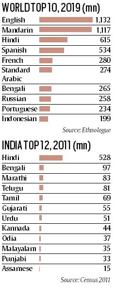
    • Globally, English remains the most widely spoken language with 1.13 billion speakers in 2019, followed by Mandarin with 1.17 billion, according to the online database Ethnologue.

    Why February 21?

    • UNESCO declared International Mother Language Day in 1999, to commemorate a 1952 protest against West Pakistan’s imposition of Urdu as the official language of East Pakistan (present-day Bangladesh).
    • According to a report, police opened fire on demonstrating Dhaka University students and “some people were killed”.
    • When thousands thronged the university the next day, police fired again, killing more people.
    • In Bangladesh, since 1953, February 21 is observed as Ekushe Day, after the Bengali word for twenty-one.
    • According to the South Asia Democratic Forum, five among those killed were recognised as “language martyrs — Abul Barkat, Abdul Jabbar, Rafiquddin Ahmad, Abdus Salman and Shafiur Rahman.

    Data on Indian languages

    • Hindi is third with 615 million speakers while Bengali is seventh with 265 million.
    • In India, Hindi is the most spoken language with over 528 million speakers in 2011, as per the Census.
    • Bengali had 97.2 million speakers in 2011, followed by Marathi (83 million), while other languages with over 50 million speakers are Telugu (81 million), Tamil (69 million), Gujarati (55.5 million) and Urdu (50.8 million).
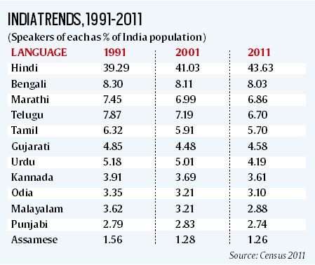
    • Percentage trends from 1991 to 2011 underline the growth of the most widely spoken language, Hindi, which was spoken by 39.29% of the Indian population in 1991, and whose share grew to 43.63% in 2011.
    • For other languages in India’s top 12, the 2011 percentage share has fallen when compared to that in 1991.
  • What did Harappan people eat?

    The National Museum in New Delhi has hosted “The Indus dining experience” a food event based on the food pattern of Indus valley civilization.

    Food of Harappans

    • Archaeological evidence from Indus Valley sites (c. 3300 BC to 1300 BC) in present-day India and Pakistan suggests that a purely vegetarian meal will not provide a complete picture of what the Harappan people ate.
    • To judge from the quantity of bones left behind, animal foods were consumed in abundance: beef, buffalo, mutton, turtles, tortoises, gharials, and river and sea fish.
    • Apart from meat, the people of the Indus Valley Civilisation grew and ate a variety of cereals and pulses.
    • There is archaeological evidence for cultivation of pea (matar), chickpea (chana), pigeon pea (tur/arhar), horse gram (chana dal) and green gram (moong).
    • Several varieties of wheat have been found at Harappan sites, as well as barley of the two-rowed and six-rowed kinds.
    • There is evidence that the Harappans cultivated Italian millet, ragi and amaranth, as well as sorghum and rice.
    • Oilseeds such as sesame, linseed, and mustard were also grown.
  • Northern European Enclosure Dam (NEED)


    An extraordinary measure to protect 25 million people and important economic regions of 15 Northern European countries from rising seas has been proposed. It is called Northern European Enclosure Dam (NEED) enclosing all of the North Sea.

    Northern European Enclosure Dam (NEED)

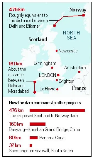
    • The scientists have proposed the construction of two dams of a combined length of 637 km — the first between northern Scotland and western Norway.
    • It would be 476 km and with an average depth of 121 m and maximum depth of 321 m; the second between France and southwestern England, of length 161 km, and average depth of 85 m and maximum depth of 102 m.
    • A/c to scientists, separating the North and Baltic Seas from the Atlantic Ocean is considered to be the “most viable option” to protect Northern Europe against unstoppable sea level rise (SLR).
    • They have also identified other regions in the world where such mega-enclosures could potentially be considered, including the Persian Gulf, the Mediterranean Sea, the Baltic Sea, the Irish Sea, and the Red Sea.

    The rationale behind

    • The concept of constructing NEED showcases the extent of protection efforts that are required if mitigation efforts fail to limit sea level rise.
    • While NEED may appear to be “overwhelming” and “unrealistic”, it could be “potentially favourable” financially and in scale when compared with alternative solutions to fight SLR, the research argues.
    • The researchers classify the solutions to SLR into three categories of taking no action, protection, and managed retreat — and submit that NEED is in the second category.
    • While managed retreat, which includes options such as managed migrations, may be less expensive than protection (NEED), it involves intangible costs such as national and international political instability, psychological difficulties, and loss of culture and heritage for migrants.
    • NEED, the paper says, will have the least direct impact on people’s daily lives, can be built at a “reasonable cost”, and has the largest potential to be implemented with the required urgency to be effective.

    Viability of NEED

    • The researchers have estimated the total costs associated with NEED at between €250 billion and €550 billion.
    • They referred to the costs of building the 33.9-km Saemangeum Seawall in South Korea and the Maasvlakte 2 extension of the Rotterdam harbour in the Netherlands as examples,
    • If construction is spread over a 20-year period, this will work out to an annual expense of around 0.07%-0.16% of the GDP of the 15 Northern European countries that will be involved.
    • Also the construction will “heavily impact” marine and terrestrial ecosystems inside and outside the enclosure, will have social and cultural implications, and affect tourism and fisheries.