💥Join UPSC 2027,2028 Mentorship (July Batch) + XFactor Notes & Microthemes PDF

GS Paper: GS1

  • In news: Mangal Pandey (1827-1857)

    Why in the News?

    The Prime Minister paid tribute to the great freedom fighter Mangal Pandey on his birth anniversary.

    Who was Mangal Pandey?

    • Birth: Born on 19 July 1827 in Nagwa village, Ballia district, Uttar Pradesh.
    • Military Service: Joined the British East India Company’s army in 1849 as a sepoy in the 34th Bengal Native Infantry at Barrackpore.
    • Trigger of Revolt: Opposed the use of Enfield rifle cartridges greased with cow and pig fat, offensive to religious beliefs.
    • Rebellion: On 29 March 1857, attacked British officers and encouraged sepoys to rise in revolt.
    • Punishment: Arrested, tried, and executed by hanging on 8 April 1857.
    • Legacy: Regarded as the “Hero of the First War of Indian Independence” and a symbol of resistance.

    Back2Basics: 1857 War of Independence

    • Overview: The First War of Indian Independence or the Great Rebellion of 1857.
    • Sepoy Composition: Indians made up over 87% of the British Indian Army but faced severe discrimination.
    • Root Causes:
      • Military Discontent: Unequal pay, poor promotion prospects, denial of allowances.
      • Religious Insensitivity: Use of animal fat-greased cartridges insulted Hindu and Muslim beliefs.
      • Economic Hardship: Heavy land taxes, decline in traditional crafts, and rising unemployment.
      • Political Grievances: Annexation of Indian states and enforcement of oppressive laws.
    • Outbreak:
      • Barrackpore: Mangal Pandey’s defiance on 29 March 1857 marked the beginning.
      • Meerut: On 10 May 1857, sepoys rebelled after refusing cartridges and were imprisoned.
      • Delhi: Rebels marched to Delhi and declared Bahadur Shah II as Emperor.
    • Spread of Revolt: Uprising expanded to Kanpur, Lucknow, Jhansi, Bihar, Bareilly, Faizabad, and beyond.
    • Mass Participation: Involved sepoys, peasants, landlords, and regional rulers.

    Suppression and Its Aftermath:

    • Brutal Suppression: Rebellion was crushed by 1859; Delhi was recaptured in September 1857.
    • Administrative Shift: British East India Company was dissolved; India came under direct British Crown rule, initiating the British Raj.
    • Military Reorganization: Indian representation in the army was reduced and reorganized to prevent future revolts.
    • Increased Repression: Racial discrimination and harsh policies intensified post-revolt.


    [UPSC 2006] Who was the Governor-general of India during the Sepoy Mutiny?

    Options: (a) Lord Canning* (b) Lord Dalhousie (c) Lord Hardinge (d) Lord Lytton


  • [19th July 2025] The Hindu Op-ed: Indian inequality and the World Bank’s claims 

    PYQ Relevance:

    [UPSC 2015] Though there have been several different estimates of poverty in India, all indicate reduction in poverty levels over time. Do you agree? Critically examine with reference to urban and rural poverty indicators.

    Linkage: The article highlights that the World Bank’s report, “India Poverty and Equity Brief: April 2025,” claims India has “almost eradicated extreme poverty” and “significantly reduced consumption inequality since 2011-12”. This directly supports the premise in the PYQ about a reduction in poverty levels.


    Mentor’s Comment:  The World Bank’s April 2025 report highlights a decline in extreme poverty in India, supported by new HCES datarevealing insights into consumption inequality. The launch of the PMDDKY aims to reform agriculture through district-level planning, despite concerns over falling public investment in agriculture. Emphasis on inclusive participation and localised implementation is crucial for sustainable growth.

    Today’s editorial analyses the World Bank’s report “India Poverty and Equity Brief: April 2025”. This topic is important for GS Paper I (Indian Society) and  GS Paper II (Social Justice) in the UPSC mains exam.

    _

    Let’s learn!

    Why in the News?

    Recently, the release of the World Bank’s report “India Poverty and Equity Brief: April 2025”, which made significant claims about the reduction in poverty and inequality in India.

    What are the key findings of the World Bank’s April 2025 report on poverty in India?

    • Extreme Poverty Has Nearly Been Eliminated: India has made substantial progress in poverty reduction over the past decade. Eg: About 27 crore people were lifted out of extreme poverty between 2011 and 2023, based on the International Poverty Line of $2.15/day (2017 PPP).
    • Consumption Inequality Has Declined: The gap between the rich and poor in consumption patterns has reduced significantly.  
    • India Among Least Unequal Countries (by Consumption): In terms of consumption distribution, India now ranks among the top four least unequal countries globally. Eg: Both rural and urban households reported increased and more balanced access to milk, eggs, fruits, and vegetables, showing better consumption equity.

    How has the HCES data helped understand consumption inequality?

    The Household Consumption Expenditure Survey (HCES) 2022–23 data has provided deep insights into consumption inequality in India.

    • Decline in Consumption Inequality: HCES showed a reduction in the consumption gap between the richest and the poorest households. Eg: The Gini coefficient for consumption dropped to 28.2 in rural areas and 31.9 in urban areas, indicating more equitable spending.
    • Improved Nutritional Access Across Income Groups: Data showed that low-income households are consuming more nutritious food than before. Eg: Compared to 2011–12, rural poor households now consume more milk, eggs, fruits, and vegetables, narrowing the dietary gap.
    • Urban-Rural Gap Has Narrowed: Consumption growth in rural India outpaced urban areas, helping to reduce regional inequality. Eg: The monthly per capita consumption rose by over 164% in rural and 146% in urban households (in nominal terms).
    • Shift Towards Non-Food Expenditure: Rising non-food spending like education, transport, and health among lower-income groups suggests improving quality of life. Eg: In rural areas, non-food items made up 50.3% of total spending, indicating broader access to services.
    • Policy Targeting Becomes Easier: The disaggregated data helps target welfare schemes better at both the state and district level. Eg: States like Odisha and Chhattisgarh, which showed rising consumption among poor households, can now be used as models for nutrition and cash transfer schemes.

    Why is distinguishing between income and consumption inequality important?

    • Households Smooth Consumption Despite Income Fluctuations: People often use savings, credit, or social networks to maintain consumption when incomes fall temporarily. Eg: A daily wage worker in Uttar Pradesh may lose work during the monsoon, but still manages basic consumption (food, rent) by borrowing from local moneylenders or using savings.
    • Public Transfers Reduce Consumption Inequality: Government subsidies and welfare schemes help the poor consume more than their income alone would allow. Eg: A family in Odisha earning low wages may still access subsidised food under the Public Distribution System (PDS) and free school meals, narrowing consumption inequality even if income remains low.
    • Informal Support Influences Consumption: Land, gold, livestock, and informal social support can enhance consumption even when income is unstable. Eg: In Maharashtra, a small farmer with seasonal income can sell stored grain or gold jewellery to fund household expenses during lean months—sustaining consumption better than someone with the same income but no assets.

    What are the steps taken by the government?

    • Expansion of Direct Benefit Transfers (DBT): The government has expanded cash transfer schemes like PM-KISAN, PM-Garib Kalyan Yojana, and Ujjwala 2.0 to ensure income support and reduce consumption inequality. Eg: As of 2024, over 11 crore farmers received ₹6,000 annually under PM-KISAN through DBT.
    • Strengthening Food Security SystemsThrough the National Food Security Act (NFSA) and One Nation One Ration Card, subsidised food grains are provided to nearly 80 crore beneficiaries, helping smoothen consumption shocks. Eg: NFSA covers 75% of rural and 50% of urban population, ensuring minimum nutrition.
    • Investment in Social Infrastructure and Welfare: Increased spending on education, health, rural housing (PMAY-G), and employment (MGNREGA) to reduce long-term structural inequality. Eg: In FY 2024-25, the budget for MGNREGA was over ₹86,000 crore, supporting rural livelihoods and stabilising consumption during crises.

    Way forward: 

    • Enhance Targeting Through Data-Driven Welfare Delivery: Leverage HCES and SECC data to better identify vulnerable households and customize welfare delivery, especially in nutrition, health, and education. Eg: Use Aadhaar-linked data and digital platforms like PM Gati Shakti to streamline benefit distribution and plug leakages.
    • Promote Employment-Led Growth in Rural and Urban Areas: Focus on labour-intensive sectors like agro-processing, textiles, and construction, while supporting MSMEs and skilling initiatives to boost income equality and domestic consumption. Eg: Scale up schemes like PM Vishwakarma and Skill India Mission to create sustainable livelihoods.
  • Disputes over Grand Ethiopian Renaissance Dam (GERD)

    Why in the News?

    The completion of Ethiopia’s Grand Ethiopian Renaissance Dam (GERD) has reignited tensions over Nile water rights, with Egypt and Sudan fearing reduced water flows.

    Disputes over Grand Ethiopian Renaissance Dam (GERD)

    About Grand Ethiopian Renaissance Dam (GERD):

    • Overview: Gravity dam on the Blue Nile near Ethiopia–Sudan border.
    • Construction Timeline: Under construction since 2011, led by Ethiopian Electric Power Corporation.
    • Capacity: Set to become Africa’s largest hydropower plant with 6.45 GW output.
    • Reservoir Size: Holds 74 billion cubic metres; filling may take 5–15 years.
    • Key Features: 145 m tall dam, 16 turbines, and a supporting saddle dam.
    • Purpose: Aims to power Ethiopia (65% population lacks electricity) and export surplus to neighbouring countries.
    • Disputes Around GERD:
      • Egypt’s Concern: Fears reduced water flow; Relies 90% on Nile; demands a binding filling agreement.
      • Sudan’s Worry: Concerns over flood risks and water regulation.
      • Ethiopia’s Stand: Asserts sovereign rights; began filling without consensus.
      • Stalled Talks: Tripartite negotiations have failed; Egypt warns of possible conflict.

    Back2Basics: Nile River

    • Overview: North-flowing, longest river in Africa at ~6,650 km.
    • Drainage Basin: Covers 11 countries—Tanzania, Uganda, Rwanda, Burundi, DRC, Kenya, Ethiopia, Eritrea, South Sudan, Sudan, and Egypt.
    • Main Tributaries:
      • White Nile: Recognized as the headstream, its most remote source is the Kagera River in Burundi, flowing through Rwanda into Lake Victoria. It officially begins at Jinja, Uganda, where it exits Lake Victoria.
      • Blue Nile: Originates from Lake Tana in Ethiopia and merges with the White Nile at Khartoum, Sudan.  Supplies over 80% of total Nile flow by the time it reaches Egypt.
    • Lifeline Status: Vital for Egypt and Sudan’s drinking water, irrigation, and energy needs.


    [UPSC 2008] Ogaden region has been a source of conflict between which countries?

    Options: (a) Morocco and Algeria (b) Nigeria and Cameroon (c) Angola and Zambia (d) Ethiopia and Somalia*


  • In news: Reykjanes Peninsula

    Why in the News?

    Recently a volcano erupted in south-west Iceland, continuing a pattern of recurring geological activity on the Reykjanes Peninsula.

    In news: Reykjanes Peninsula

    About the Reykjanes Peninsula:

    • Location: Situated in southwest Iceland along the Mid-Atlantic Ridge where tectonic plates diverge.
    • Volcanic Reawakening: Dormant for centuries until 2021; now sees recurring eruptions.
    • Eruption Type: Known for fissure eruptions—lava flows from cracks, not a central crater.
    • Key Sites: Includes Grindavik (evacuated), Blue Lagoon spa, and Svartsengi power plant.
    • Volcanic Importance: Part of Iceland’s 30+ active volcanic zones.

    Key Features:

    • Eruption Style: Produces steady lava flows with minimal ash output.
    • Flight Safety: Air traffic remains unaffected due to lack of stratospheric ash.
    • Evacuation Impact: Grindavik largely abandoned after 2023 lava threat.
    • Long-Term Activity: Eruptions may persist for decades or longer.
    • Iceland Snapshot: Population ~400,000; similar in size to Kentucky.
    • Tourism Appeal: Attracts visitors like other volcanic hotspots—Mexico, Indonesia, Sicily, and New Zealand.
    [UPSC 2014] Consider the following geological phenomena:

    1. Development of a fault 2. Movement along a fault

    3. Impact produced by a volcanic eruption 4. Folding of rocks

    Which of the above cause earthquakes?

    Options: (a) 1, 2 and 3 (b) 2 and 4 (c) 1, 3 and 4 (d) 1, 2, 3 and 4*


  • Tipu Sultan and Anglo-Mysore Wars (1767-1799)

    Why in the News?

    The new NCERT Class 8 Social Science textbook omits Tipu Sultan, Haidar Ali, and the Anglo-Mysore Wars from its chapter on India’s colonial era.

    Tipu Sultan and Anglo-Mysore Wars (1767-1799)

    Legend of Tipu Sultan and Haidar Ali:

    • Rise of Haidar Ali: Started as a horseman in the Mysore army and became de facto ruler by 1761 through military skill.
    • Military Reforms: Introduced Western training, built arms factories with French help, and strengthened cavalry and artillery.
    • Tipu Sultan: Born in 1751, trained by French officers and well-versed in Islamic law, Persian, Arabic, and science.
    • Administrative Innovations: Introduced a new calendar, land revenue reforms, and coins in gold, silver, and copper with Persian inscriptions.
    • Governance and Industry: Created seven departments, promoted silk industry, and envisioned the future Kannambadi Dam.
    • French Alliance: Maintained strong ties with France, alarming the British amid global Anglo-French rivalry.
    • Technological Advancement: Deployed iron-cased Mysorean rockets, which inspired British Congreve rockets.
    • Moral Governance: Banned liquor, gambling, and prostitution to enforce discipline.
    • Religious Policy: Though devoutly Islamic, he patronized temples and mathas, but faced criticism for intolerance in annexed regions.

    About the Anglo-Mysore Wars:

    First Anglo-Mysore War (1767–69)

    • Alliance Against Mysore: British, Marathas, and Nizam formed a coalition against Haidar Ali.
    • Diplomatic Victory: Haidar neutralized the Marathas and secured Nizam’s support.
    • Outcome: Treaty of Madras (1769) restored the status quo and mutual restitution of territories.

    Second Anglo-Mysore War (1780–84)

    • Trigger: British violation of the Treaty of Madras and occupation of French port Mahe.
    • Coalition Formation: Haidar allied with Marathas and Nizam against the British.
    • Major Battle: Captured Arcot and defeated Col. Baillie; Haidar died in 1782.
    • Conclusion: Tipu continued the fight; Treaty of Mangalore (1784) was the last time an Indian power dictated terms to the British.

    Third Anglo-Mysore War (1790–92)

    • Cause: Tipu’s attack on Travancore, a British ally.
    • British Response: Cornwallis led a coordinated campaign with Maratha and Nizam support.
    • Result: Tipu ceded half his territory and paid ₹3 crore under the Treaty of Seringapatam (1792).

    Fourth Anglo-Mysore War (1799)

    • British Strategy: Wellesley isolated Tipu diplomatically over his French ties.
    • Final Battle: Tipu was killed defending Seringapatam on May 4, 1799, ending native resistance in South India.

    Aftermath of the Wars:

    • Fall of Resistance: Tipu’s death marked the end of organized native military opposition in the South.
    • British Control: Wodeyars reinstated as puppet rulers under Subsidiary Alliance; key territories annexed by the British.
    • Territorial Division: Nizam received Gooty and Gurramkonda; Marathas declined British land offer.
    • Administrative Changes: Mysore came under direct British rule in 1831 due to alleged misrule; restored to Wodeyars in 1881 by Lord Ripon under a constitutional monarchy.
    • Legacy: Anglo-Mysore Wars showed how native resistance could challenge colonial power through modernization, alliances, and tactical innovation.
    • Rocketry Influence: Tipu’s military rocketry was studied and adapted by the British into European warfare.
    [UPSC 2014] With reference to the Anglo-Mysore Wars, consider the following statements:

    1. In the Third Battle of Panipat, Ahmed Shah Abdali defeated Ibrahim Lodi.

    2. Tipu Sultan was killed in the Third Anglo-Mysore War.

    3. Mir Jafar entered in a conspiracy with the English for the defeat of Nawab Siraj-ud-daulah in the Battle of Plassey.

    Which of the statements given above is/are correct?

    (a) 1, 2 and 3 (b) 3 only* (c) 2 and 3 (d) None


  • Machilipatnam as Ancient Port is set for big Revival

    Why in the News?

    Machilipatnam, once a flourishing ancient port city on India’s east coast, is witnessing a major transformation with the construction of a modern Greenfield port.

    Machilipatnam as Ancient Port is set for big Revival

    About Machilipatnam:

    • Alternate Names: Also known as Masulipatnam, Maisolia, or Manjarika.
    • Geographic Location: Located in Krishna district, Andhra Pradesh, on the southeastern Coromandel Coast, at the mouth of River Krishna, ~70 km east of Amaravati.
    • Historical Importance:
      • One of the most significant east coast port cities for ~1,700 years.
      • Played a key role in maritime trade across ancient, medieval, and early modern periods.
    • Global Trade Connections:
      • Attracted traders from Rome, Arabia, Persia, Southeast Asia, and Europe.
      • Known for exporting high-quality Muslin textiles prized in Roman markets.
      • The term “muslin” likely derives from “Maisolia,” an ancient name of the city.
    • Cultural Contributions:
      • Known for Kalamkari art, a traditional textile art featuring hand-painted or block-printed designs.
    • Dynastic Port Usage:
      • Satavahanas (1st BCE – 2nd CE): Used as a major trade gateway.
      • Vishnukundins (4th–6th CE): Trade wealth supported Buddhist monument construction (e.g., Nagarjunakonda).
      • Qutb Shahis (16th–17th CE): Transformed it into a global hub for diamonds, muslin, and Kalamkari.
      • Nizams of Hyderabad (18th century): Controlled the port until partial cession to the British.
    • Mentions in Ancient Texts:
      • Appears as Maisolia in Periplus of the Erythraean Sea.
      • Listed as Maisolos in Ptolemy’s Geographia.
    • Colonial Involvement:
      • Dutch built a fort in the 17th century.
      • British East India Company established its first Bay of Bengal factory here in 1611.
      • Between 1686–1759, it changed hands among French, Dutch, and British; seized by British from the French in 1759.
    • Decline of the Port:
      • Anchorage Issue: Unsuitable for large ships, with anchorage 5 miles offshore.
      • Cyclone Damage: A severe cyclone in 1779 killed ~20,000 and destroyed Dutch structures.
      • Trade Shift: Decline due to growing prominence of Madras (Chennai) and Visakhapatnam under British rule.
    • Post-Independence Claim:
      • In 1947, 7th Nizam of Hyderabad attempted to reclaim it for sea access to an independent Hyderabad state.
    • Modern Revival:
      • A Greenfield port at Manginapudi is under construction, expected to be operational by 2026.
      • Aims to restore Machilipatnam’s historical maritime legacy.
    [UPSC 2023] With reference to ancient South India, Korkai, Poompuhar and Muchiri were well known as:

    (a) capital cities (b) ports* (c) centres of iron and steel making (d) shrines of Jain Tirthankaras


  • Behdeinkhlam Festival celebrated in Meghalaya

    Why in the News?

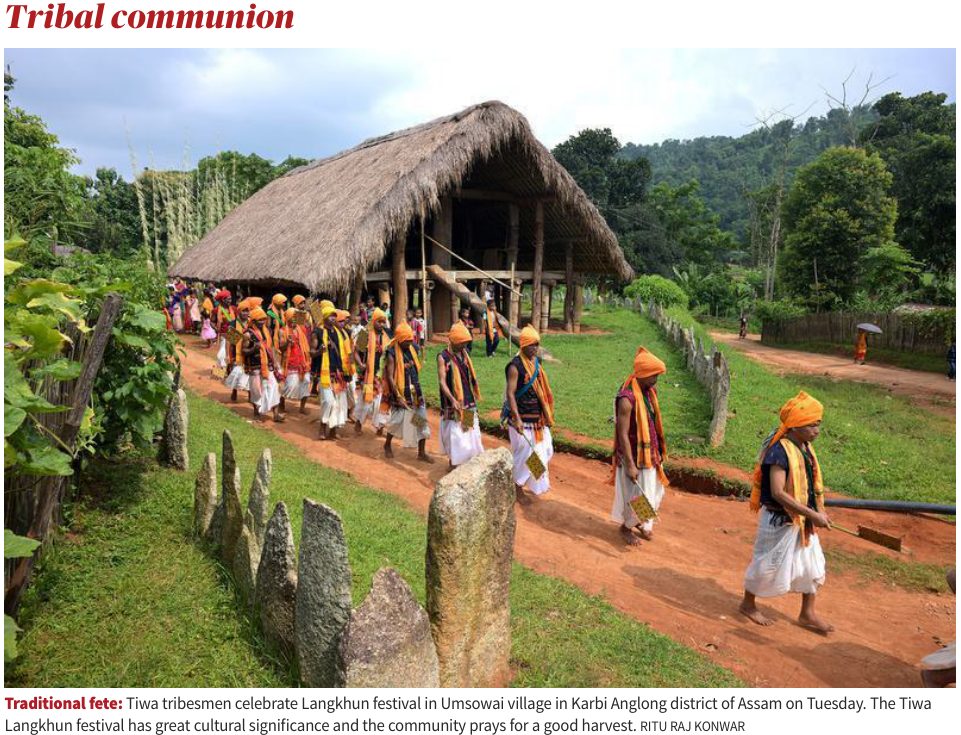
    The Behdienkhlam Festival of Pnar (Jaintia) community in Meghalaya was recently celebrated.

    Behdeinkhlam Festival celebrated in Meghalaya

    About Behdienkhlam Festival:

    • Cultural Role: Major religious and cultural festival of the Pnar (Jaintia) community in Meghalaya.
    • Location: Four-day festival held in Jowai, West Jaintia Hills.
    • Meaning: Means driving away the plague or evil.
    • Timing: Celebrated in mid-July after sowing season.
    • Purpose: Prayers for a good harvest and community cleansing.
    • Faith: Observed mainly by followers of the Niamtre religion.
    • Women’s Role: Women offer food to ancestors but do not dance in rituals.

    Key Features:

    • Rituals: Dolois perform rites to drive away disease and evil.
    • Symbolic Act: Youth beat rooftops with bamboo sticks to expel evil.
    • Rots: 30–40 ft decorated bamboo structures with social themes.
    • Khnong Ritual: Teams pull a large wooden beam and immerse it in mud.
    • Dad-Lawakor: Traditional football-like game predicting harvest success.
    • Celebrations: Mass dancing at Wah Aitnar pool with drums and pipes.
    [UPSC 2012] Chapchar Kut is a festival celebrated in the state of:

    Options: (a) Arunachal Pradesh (b) Assam (c) Mizoram* (d) Sikkim


  • [17th July 2025] The Hindu Op-ed: A tectonic shift in thinking to build seismic resilience

    PYQ Relevance:

    [UPSC 2015] Earthquakes along the plate margins are still a cause of concern. India’s preparedness for mitigating their impact has significant gaps. Discuss various aspects.

    Linkage: The article emphasizes that India’s seismic risk is rooted in the northward drift of the Indian Plate colliding with the Eurasian Plate, which shaped the Himalayas and makes the region “overdue for a ‘Great Himalayan Earthquake’.  The question specifically mentions “earthquakes along the plate margins” and critically highlights “India’s preparedness for mitigating their impact has significant gaps.


    Mentor’s Comment:  The 4.4 magnitude tremor in Delhi on July 10, 2025, though moderate, exposed the critical fragility of India’s infrastructure, especially in Delhi, where over 80% of buildings violate seismic safety norms. This event is part of a wider pattern of seismic activity across Asia, underlining the urgent need for earthquake preparedness. India, particularly northern and northeastern regions, lies in high-risk seismic zones (IV & V) due to the collision of tectonic plates, making a massive quake imminent. Urbanisation, outdated construction, and poor enforcement of seismic codes like IS 1893:2016 worsen the risk.

    Today’s editorial analyses the vulnerability to earthquakes in India. This topic is important for GS Paper I (Geography) and  GS Paper III (Disaster Management) in the UPSC mains exam.

    _

    Let’s learn!

    Why in the News?

    On July 10, 2025, a 4.4 magnitude earthquake struck near Delhi, exposing the fragile state of infrastructure.

    Why is Delhi vulnerable to earthquakes?

    • High Seismic Risk Zone: Delhi lies in Seismic Zone IV, indicating a severe seismic hazard with a peak ground acceleration (PGA) of around 0.24g. Eg: Similar Zone IV cities like Srinagar and Patna have experienced strong tremors in the past.
    • Poor Structural Compliance: Over 80% of buildings in Delhi, especially those constructed before 2000, do not comply with seismic safety codes. Eg: Unregulated high-rise apartments in East Delhi lack ductile detailing or shear walls, making them prone to collapse.
    • Liquefaction-Prone Areas: Areas like East Delhi and Yamuna floodplains are built on soft alluvial soils, which are susceptible to liquefaction during earthquakes. Eg: In the 2001 Bhuj earthquake, structures on soft soil experienced severe tilting and collapse.
    • Rapid Urbanisation Without Planning: Delhi’s urban sprawl and dense population (over 33 million) have led to haphazard construction, often violating zoning and structural norms. Eg: Many illegal colonies like those in outer Delhi lack any seismic design considerations.

    What are the vulnerable areas in India? 

    • Himalayan Region: The Himalayan belt is highly prone to earthquakes due to the collision of the Indian and Eurasian tectonic plates. Eg: Regions like Jammu & Kashmir, Himachal Pradesh, Uttarakhand, and parts of Northeast India fall under Seismic Zone V.
    • Indo-Gangetic Plain: This region experiences significant seismic activity due to the tectonic stress transfer from the Himalayan region. Eg: Parts of Bihar, Uttar Pradesh, Delhi, and West Bengal lie in Seismic Zones III and IV.
    • Peninsular India Fault Zones: Though considered geologically stable, intraplate faults in Peninsular India can still trigger strong earthquakes. Eg: Areas like Latur (Maharashtra), Koyna (Maharashtra), and Bhuj (Gujarat) have witnessed major quakes in the past.

    What are the steps taken by the Indian Government? 

    • Building Code Reforms: The government enforces Earthquake-Resistant Building Codes to ensure structural safety in seismic zones. Eg: The Bureau of Indian Standards (BIS) revised IS 1893 and IS 4326 to include updated seismic design norms across construction sectors.
    • National Seismic Zoning: India has been zoned into seismic risk areas to guide planning and construction based on earthquake vulnerability. Eg: The country is divided into Zone II to Zone V, with Zone V (like parts of Uttarakhand, Kashmir) being most earthquake-prone.
    • Disaster Management Framework: The government has established a dedicated institutional framework to coordinate disaster preparedness and response. Eg: The National Disaster Management Authority (NDMA) issues guidelines for earthquake risk mitigation and conducts regular mock drills and capacity-building programs.

    What are the steps taken at the international level?

    • Sendai Framework for Disaster Risk Reduction (2015–2030): The United Nations adopted this global framework to strengthen disaster preparedness, promote resilient infrastructure, and reduce disaster losses. Eg: Countries like Japan and Chile have aligned their national disaster policies with Sendai priorities, emphasizing risk governance and early warning.
    • Global Seismic Hazard Assessment Program (GSHAP): Led by the International Lithosphere Program, this initiative provides seismic hazard maps to help countries plan safer infrastructure. Eg: Italy and other European nations use GSHAP data to revise building codes and zoning laws in earthquake-prone zones.
    • Early Warning Systems and Technology Sharing: Countries are collaborating to develop earthquake early warning systems and share real-time seismic data across borders. Eg: The Pacific Tsunami Warning Center and Japan’s Earthquake Early Warning System help neighbouring nations prepare faster for seismic events.

    What global lessons can India adopt from other countries? (Way forward)

    • Building Code Enforcement: Strong and regularly updated building codes ensure that infrastructure can withstand seismic shocks, reducing casualties and damage. Eg: After the 1995 Kobe earthquake, Japan revised its seismic building codes, which helped limit destruction during the 2011 Tōhoku earthquake.
    • Early Warning Systems: Timely alerts enable people to take quick protective actions, such as evacuation or shutting down utilities, before the shaking begins. Eg: In 2017, Mexico City’s SASMEX system gave a 20-second alert before the quake struck, allowing residents to prepare.
    • Retrofitting Incentives: Providing financial support for retrofitting older buildings motivates citizens to strengthen structures against earthquakes. Eg: The Earthquake Brace + Bolt program in California offers funds to homeowners, promoting structural safety in vulnerable areas.
  • In news: Great Trigonometric Survey (GTS)

    Why in the News?

    This newscard highlights the role of Indian assistants in completing the Great Trigonometric Survey (GTS), which began in 1802 to map India’s geography.

    About the Great Trigonometrical Survey (GTS):

    • Launch and Objective: The GTS was a massive scientific and cartographic initiative launched in 1802 by the British to map India with unprecedented precision using trigonometry and geodesy.
    • Initiator: It was conceptualised by William Lambton, a British army officer, and carried out under the East India Company.
    • Purpose: It aimed to measure Earth’s curvature, create accurate maps, and support colonial administration, scientific research, and military planning.
    • Survey Method: It used triangulation, involving a network of interconnected triangles built from a known baseline to calculate distances and angles over large areas.
    • First Baseline: The initial baseline was measured in 1802 at St. Thomas Mount near Madras (Chennai) and extended over 2,600 km up to the Himalayas.
    • Instruments Used: The survey used massive theodolites (weighing up to half a ton) and measuring chains, requiring large teams for operation and transport.
    • Scientific Outcome: It led to the formulation of the Everest Spheroid, a geodetic reference model still used for mapping in South Asia.
    • Duration and Leadership: Although planned to take 5 years, the project lasted nearly 70 years (until 1871) and was led by successors such as George Everest (after whom Mt. Everest was named), Andrew Scott Waugh, and James Walker.

    How did the GTS led to the Mapping of India?

    • First Accurate Maps: It provided scientific maps that corrected earlier errors, enabling modern geodetic frameworks for administration and infrastructure.
    • Survey Range: It mapped from southern India to the Himalayas, supporting large-scale development and scientific measurement.
    • Great Arc Measurement: It measured the Great Arc (Chennai to Dehradun), a significant geodetic arc that helped calculate Earth’s curvature.
    • Himalayan Heights: Using triangulation data, the survey measured 79 Himalayan peaks, including Mount Everest, K2, and Kangchenjunga.
    • Mount Everest Identification: In 1852, Peak XV was identified as the world’s highest mountain, later named Mount Everest in honour of George Everest.
    • Latitude-Longitude System: It produced precise longitude and latitude coordinates, crucial for navigation, military logistics, and administration.
    • Infrastructure Impact: Survey benchmarks supported railways, roads, canals, and earthquake studies, many of which remain relevant today.

    Contribution of Indians to the GTS:

    • Syed Mir Mohsin Husain: A jeweller from Arcot who repaired critical instruments and was later appointed as an instrument maker in the Surveyor General’s office.
    • Radhanath Sikdar: An Indian mathematician who calculated the height of Mount Everest in 1852, confirming it as the tallest peak globally.
    • Indian Field Workers: Thousands of Indian flagmen, khalasis, and labourers undertook challenging tasks like carrying heavy equipment, setting markers, and working in hazardous environments.
    • Logistical Support: Indian artisans and technicians repaired, calibrated, and adapted instruments, making the project feasible under Indian conditions.
    • Role of Pundits: Trained Indian “pundits” conducted secret surveys in Tibet and politically sensitive regions, where British officers were restricted.
    [UPSC 2018] Among the following cities, which one lies on a longitude closest to that of Delhi?

    Options: (a) Bengaluru* (b) Hyderabad (c) Nagpur (d) Pune


  • Jarawa Tribe of Andaman Islands

    Why in the News?

    Ahead of the 16th Census of India, experts have stated that counting the six main indigenous tribes of the Andaman and Nicobar Islands, including the Jarawa, is feasible.

    Jarawa Tribe of Andaman Islands

    About Jarawa Tribe:

    • Location: They live in the Middle and South Andaman Islands of India.
    • Official Status: They are classified as a Particularly Vulnerable Tribal Group (PVTG) by the GoI.
    • Population Growth: Their population has risen from 260 (1998) to around 647 (2025) due to better healthcare and low external interference.
    • First Contact: Voluntary contact with outsiders began in 1997, allowing limited medical aid, schooling, and trade.
    • Key Features:
      • Lifestyle: They are hunter-gatherers and fisherfolk, moving in nomadic groups of 40–50 individuals.
      • Ancestry: Believed to be descendants of the extinct Jangil tribe and among the earliest human migrants from Africa.
      • Health Profile: They maintain strong physical health with low incidence of lifestyle diseases like diabetes and hypertension.
      • Lifespan: Natural childbirth is common, and the average lifespan now exceeds 50 years.

    Note:

    The Andaman and Nicobar Islands are home to 5 PVTGs, which are among the most isolated and distinct indigenous communities in India. They are- Great Andamanese, Jarawas, Onges, Sentinelese, Shompens.


    Back2Basics: Particularly Vulnerable Tribal Groups (PVTGs)

    • Overview:  They are a subgroup within Scheduled Tribes considered most backward and vulnerable.
    • Habitat: They generally inhabit remote localities having poor infrastructure and administrative support.
    • Distribution: There are 75 such groups identified and categorized PVTGs.
    • Origin of the concept:
      • The Dhebar Commission (1960-1961) stated that within Scheduled Tribes there existed an inequality in the rate of development.
      • During the 4th Five Year Plan (1969-74) a sub-category was created within Scheduled Tribes to identify groups that were considered to be at a lower level of development.
      • This sub-category was named “Primitive tribal group”.
      • In 2006 the government of India proposed to rename PVTGs.
    • Features of PVTGs: Groups that satisfied any one of the criteria are considered PVTGs:
      1. Pre-agricultural system of existence
      2. The practice of hunting and gathering
      3. Zero or negative population growth
      4. Extremely low level of literacy in comparison with other tribal groups.


    [UPSC 2019] Consider the following statements about Particularly Vulnerable Tribal Groups (PVTGs) in India:

    1. PVTGs reside in 18 States and one Union Territory.

    2. A stagnant or declining population is one of the criteria for determining PVTG status.

    3. There are 95 PVTGs officially notified in the country so far.

    4. Irular and Konda Reddi tribes are included in the list of PVTGs.

    Which of the statements given above are correct?

    Options: (a) 1, 2 and 3 (b) 2, 3 and 4 (c) 1, 2 and 4* (d) 1, 3 and 4