Why in the News:
Elon Musk’s Starlink will soon launch in India, promising high-speed internet access in regions beyond the reach of ground-based networks. This is significant as it can bridge rural-urban gaps, improve disaster resilience, and strengthen defence capabilities. Globally, satellite internet has been a lifeline during Hurricane Harvey and a tactical tool in the Russia-Ukraine war. For India, it represents both a technological leap and a strategic necessity.
Introduction:
In today’s digitised and interconnected world, internet access is as vital as electricity or transport. Traditional cable and tower-based networks excel in cities but falter in remote terrains. Satellite internet, powered by mega-constellations like Starlink, offers a borderless, high-resilience alternative that operates irrespective of geography.
Why are ground-based internet networks economically unviable in certain regions?
- Physical Infrastructure Limits: Cables and towers are uneconomical for sparsely populated or remote regions
- Disaster Vulnerability: Infrastructure can be wiped out during floods, earthquakes, or storms
- On-the-Go Connectivity Gap: Mobile and temporary operations (airplanes, ships, oil rigs) often remain underserved
How does satellite internet overcome these challenges?
- Global Coverage: Operates regardless of terrain or terrestrial infrastructure
- Rapid Deployment: Can be set up quickly to meet sudden demand surges
- Mobility Advantage: Supports moving platforms and remote sites
- Dual-Use Potential: Functions for both civil and military purposes (e.g., Ukrainian defence, Siachen Glacier operations)
What makes the new wave of satellite internet significant?
- Mega-Constellations: Networks like Starlink have thousands of satellites in Low Earth Orbit (LEO)
- Disaster Response Role: Viasat aided Hurricane Harvey operations when 70% of cell towers failed.
- Defence Integration: Ukrainian drones fitted with Starlink to bypass Russian jamming; Indian Army use in high-altitude conflict zones
- Security Concerns: Smuggled Starlink devices used by insurgent groups and drug cartels
Working of satellite internet:
- Two Segments: Space segment (satellites) and ground segment (user terminals, gateways).
- Service Life: Satellites operate for 5–20 years depending on design.
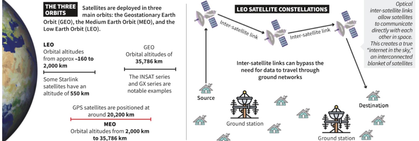
- Orbits:
- GEO (35,786 km): Wide coverage, high latency; unsuitable for real-time apps. Example: Viasat GX.
- MEO (2,000–35,786 km): Medium latency, requires constellations. Example: O3b.
- LEO (<2,000 km): Low latency, small coverage; requires mega-constellations. Example: Starlink’s 7,000+ satellites.
Key Differences between satellites in GEO, MEO AND LEO:
| Feature | Geostationary Earth Orbit (GEO) | Medium Earth Orbit (MEO) | Low Earth Orbit (LEO) |
| Altitude | 35,786 km above equator | 2,000 – 35,786 km | Below 2,000 km |
| Relative Motion | Stationary relative to a point on Earth | Moves relative to Earth | Moves quickly relative to Earth |
| Coverage | ~1/3 of Earth (no polar coverage) | Larger than LEO, smaller than GEO; needs constellation for global coverage | Small footprint; single satellite covers area like an Indian metro city |
| Satellite Size | Large | Large | Smaller, often table-sized |
| Cost & Deployment | Expensive, long deployment | Expensive, smaller constellations | Cheaper, quicker to deploy |
| Latency | High (unsuitable for time-sensitive apps) | Medium (lower than GEO but still limits real-time use) | Very low (good for real-time use) |
| Example | Viasat Global Xpress (GX) | O3b constellation (20 satellites) | Starlink (7,000+ satellites, aiming for 42,000) |
| Key Drawback | High delay due to distance | Still costly, latency not ideal for all uses | Needs thousands of satellites for global coverage |
How do LEO mega-constellations maintain connectivity?
- On-Board Processing: Improves efficiency and reduces terminal complexity
- Optical Inter-Satellite Links: Satellites communicate directly in space for faster routing
- Seamless Handoff: Steerable antennas track multiple satellites to maintain uninterrupted service
What are the key applications of satellite internet?
- Civil Connectivity: Rural broadband, IoE (Internet of Everything)
- Transportation: Navigation, self-driving cars, logistics optimisation
- Public Administration: Smart cities, disaster warnings, rescue coordination
- Healthcare: Telemedicine, remote diagnostics
- Agriculture: Precision farming, crop health monitoring
- Defence & Security: Real-time communication in conflict zones, strategic surveillance
Conclusion
Satellite internet represents not just a technological upgrade but a strategic asset in the digital era. For India, it offers a pathway to bridge the digital divide, enhance national resilience, and project influence in the global communications domain. However, its dual-use nature demands strong regulatory frameworks to balance innovation, accessibility, and security.
Value Addition |
Key Terms & Phrases Explained
|
Mapping Micro Themes
| Paper | Macro Theme | Micro Themes | Sub-Micro / Example |
| GS Paper III | Types of Orbits | GEO (Geostationary) | INSAT series, GSAT satellites |
| MEO (Medium Earth Orbit) | O3b constellation for broadband | ||
| LEO (Low Earth Orbit) | Starlink, OneWeb | ||
| GS Paper III | Application in Navigation | GNSS Variants | GPS (USA), GLONASS (Russia), Galileo (EU), IRNSS/NavIC (India) |
| LEO & MEO in Navigation | Faster signals, better coverage | ||
| GS Paper II | Policy & Governance | India’s Space Policy 2023 | PPP in satellite communication |
| International Coordination | ITU spectrum allocation |
Practice Mains Question:
Discuss the potential of satellite internet in bridging the digital divide in India. Examine the associated security and regulatory challenges.
PYQ Linkage:
| [UPSC 2018] Why is the Indian Regional Navigational Satellite System [IRNSS] needed? How does it help in navigation?
Linkage: IRNSS (also called NavIC) is India’s indigenous satellite-based navigation system providing accurate position information over India and surrounding regions. Just like IRNSS uses satellites for positioning, satellite internet uses similar orbital infrastructure for data connectivity. Understanding satellite orbits, latency, and ground segments from this topic directly aids in explaining IRNSS’s working, advantages, and strategic value in navigation. |

