The ongoing tensions between Russia and Ukraine have led to the prices of crude oil shooting to $130/barrel. Green hydrogen is an emerging option that will help reduce India’s vulnerability to such price shocks.
Four deficiencies in Renewable Energy Technologies
1] Intermittent nature of RE: RE can only be generated intermittently.
Battery technology cannot store electricity at a grid scale.
2] Financial viability: There are question marks on the financial viability of green power.
In India, renewable electricity is a replacement for coal-based power, the cheapest form of energy.
That’s a big constraint on its viability.
Moreover, the customers of this power – the state distribution companies – are collectively insolvent.
A business cannot prosper if its primary customers are not financially viable.
3] Batteries are not suitable for heavy trucks: While electric cars and two-wheelers get a lot of visibility, much of India’s oil is burnt in heavy trucks.
Lithium batteries are not viable for trucks.
4] Critical minerals: Electric vehicles require large quantities of lithium and cobalt that India lacks.
These minerals also have very concentrated supply chains that are vulnerable to disruptions.
Large-scale investments in electric vehicles may create unsustainable dependencies for the country.
Is green hydrogen a solution?
Intermittent hydrogen in the energy mix can help circumvent some of these problems.
Hydrogen is an important industrial gas and is used on a large scale in petroleum refining, steel, and fertiliser production.
As of now, the hydrogen used in these industries is grey hydrogen, produced from natural gas.
Green hydrogen produced using renewable energy can be blended with grey hydrogen.
This will allow the creation of a substantial green hydrogen production capacity, without the risk that it may become a stranded asset.
Creating this hydrogen capacity will provide experience in handling the gas at a large scale and the challenges involved.
Blending with CNG: To widen the use of green hydrogen, it can be blended with compressed natural gas (CNG), widely used as a fuel for vehicles in Delhi, Mumbai and some other cities.
This will partly offset the need for imported natural gas and also help flag off the challenges of creating and distributing hydrogen at a national level.
By bringing down the price of green hydrogen sufficiently, India can help unlock some stranded assets.
The country has close to 25,000 megawatts of gas-fired power generation capacity that operates at a very low-capacity utilisation level. The high price of natural gas reduces the viability of such electricity.
These plants could use hydrogen blended with natural gas. Hydrogen should, however, be used to generate electricity after it has served its utility in other avenue.
Way forward
To catalyse a hydrogen economy, India needs some specialist players to execute projects as well as finance them.
Participation of private players: Apart from government-backed players, the hydrogen economy will need private sector participation.
India’s start-up sector, with over 75 unicorns, is perhaps the most vibrant part of the country’s economy currently.
This ecosystem has been enabled by a mix of factors, including the presence of entrepreneurs with ideas and investors who are willing to back up these ideas
Creation of refueling network: One challenge of using new transport fuels, whether CNG or electric vehicles, is the creation of large-scale refuelling networks.
Bringing hydrogen vehicles on the road too soon will require the creation of yet another set of infrastructure.
Building fleets of hydrogen-fueled vehicles for gated infrastructure can be a good starting point.
Airports, ports and warehouses, for instance, use a large number of vehicles such as forklifts, cranes, trucks, tractors and passenger vehicles.
Conclusion
The government’s Green Hydrogen Policy sends the right signals about its intent. It now needs to ensure that investment can freely come into this space.
Can You Take The Challlenge of Completing 40 Full Length Tests in 60 Days Along With Revising 1.5 Years of Current Affairs? Santosh Gupta Sir, who has cleared prelims 6 times will help you out.
Are you ready for Prelims-2022 in the next 60 days? If not, what’s stopping you? What’s making you wish if you had an extra 3-4 months to refine your preparation?
Is it because you are stuck at a certain marks range like the 80-90s in your mock test series? Do you feel time is too short right now to improve your marks? But do you know, these 60+ days are more than enough for you to score above 130+ in Prelims 2022? Santosh Gupta sir is here for you.
The next 60 days can make or break your UPSC-CSE dreams. Either, you might score 90-100 marks and NOT qualify for Prelims or you can get 120-130+ and start preparing for Mains.
Super-25 60 Day Revision Program Details
Start Date
April 05, 2022
Three Main Pillars of Super-25 Revision Program
This program is 100% useful for those aspirants who have already completed their prelims preparation and are worried of how would they do a final revision of all the 8 subjects in 8 weeks time. Those who want to solve atleast one 3-hour prelims test everyday, get on a call with their mentor and learn how to make effective micro-notes will find this program useful.
The program is well-organised with a fixed schedule of tests, notes, and mentorship call as per student’s request. Super-25 Prelims Revision program eliminates the last minute clutter of UPSC preparation.
1. Covers 1500 high probable topics from Current Affairs and Static portions.
2. 40 Full Length Tests ( 12 Basic + 10 Current affairs + 6 advanced + 8 full syllabus + 4 CSATs)
3. 1-on-1 Regular Mentorship for every aspirants
Faculty of Super-25
Core Faculty of Civilsdaily, who have cleared UPSC Prelims 6 times and attended interview multiple times – Sajal sir, Sudhanshu sir, Sukanya ma’am, Birendra sir and Santosh sir) will cover 1500 high probable topics with combined experience of 30 Prelims success.
Core faculty ( Sukany Ma’am, Parth, Birendra, Kesavardhan and Santosh Gupta sir) will provide personalized timetable and practical strategies for prelims success.
1.5 years ( January 2021-April 2022) of Current Affairs will be covered to ensure comprehensive coverage. The value-added notes will have current affairs news interlinked with static subjects.
The Budget and Economy Survey of 2022 will be discussed in detail. Every concept under it will be taught so that the student gains clarity. Probable questions from this portions will also be discussed.
30 Revision Classes with Strategy sessions by Santosh Gupta sir on most probable topics for Prelims 2022.
How was Super-25 Phase A & B?
If you believe you have that unshakeable dedication to go to any length to achieve your goals, it’s time to stop despairing about your low prelims scores in the mock tests.
You can undoubtedly pass the exam if you have the necessary determination and mindset and the appropriate approach and preparation technique.
Aspirants who believed in themselves did not let their wrong preparation practices deter them. Instead, they enrolled themselves in Santosh Sir’s Super-25 Phase A & B Program and basked in their improvements!
Repeated surveys have found that the incomes of migrant households continue to be lower than pre-pandemic levels, even after returning to cities.
Lack of policy for migrants
In the wake of a nationwide lockdown, India was left shocked by the plight of migrant workers walking hundreds of kilometres.
They became the focus of large-scale relief efforts by governments and civil society alike.
The Government ramped up the One Nation One Ration Card (ONORC) project, announced the Affordable Rental Housing Complexes (ARHC) scheme, set up the e-Shram portal and began to draft a migration policy.
Despite this, a cohesive migration policy guidance remains elusive.
Contribution of migrant workers: Today, a third of the nation’s workforce is mobile.
Migrants fuel critical sectors such as manufacturing, construction, hospitality, logistics and commercial agriculture.
Despite clear economic and humanitarian reasoning to bring migrants back into the policy discourse, the current policy scenario is at best fragmented and at worst waning.
Structural constraints
1] Politicisation of issue and fragmented policy response
Migration is a highly politicised phenomenon in India.
‘Destination States’ experience a tension between economic needs, which require migrant labour, and political needs, which promote nativist policies that impose domicile restrictions on employment and social security.
On the flip side, the ‘sending States’ are highly motivated to serve their “own people” because they vote in their source villages.
This fragmented policy response to internal migration follows from State-specific calculations.
Development policy in India has bet big on rural development as an antidote to migration.
This widespread ‘sedentary bias’ continues to influence policy even though migration is an important pathway for impoverished marginalised rural households to find economic security (and social emancipation).
2] Categorisation challenge
Migrants are a perennially fuzzy category in policy discourse, located inside two larger categories: the unorganised worker and the urban poor.
Even the e-Shram portal, which has made impressive progress in registering unorganised workers, has been unable to accurately distinguish and target migrants.
Policy interventions in major urban destinations continue to conflate the urban poor with low-income migrants.
Hence, slum development continues as the primary medium for alleviating migrant concerns, while in reality, most migrants live on worksites that are entirely out of the policy gaze.
3] Gaps in the data
Migration policy discourse is seemingly paralysed by the now well-acknowledged failure of official datasets to capture the actual scale and the frequency of internal migration in India.
Data systems designed to periodically record only one spatial location have posed great challenges to welfare delivery for up to 500 million people who are part of multi-locational migrant households.
The novel coronavirus pandemic has placed a sharp focus on problems such as educating and vaccinating those children who accompany their migrant parents, or ensuring that migrant women avail maternity benefits at multiple locations.
Way forward: Strategic policy guidance by Centre and a platform for inter-State coordination
Policy in India often emerges from the ground up, taking decades to cement into national law and standard practice.
We have seen this in education and food security.
State’s initiatives: In migration too, many States have initiated data projects that can track migrants and generate dynamic real-time data that aid welfare delivery.
Maharashtra’s Migration Tracking System (MTS), Chhattisgarh’s State Migrant Workers Policy is premised on registering migrant workers at source and tracking them through phone-based outreach systems.
Multisectoral approach: There is further need for multisectoral approaches underpinned by a strategic convergence across government departments and initiatives.
Odisha’s Planning and Convergence Department, which offers an institutional mechanism for inter-departmental coordination, is one possible model.
Important role of the Centre: State-level political economy constraints make the Centre’s role particularly crucial in addressing issues of inter-State migrant workers at ‘destination States’.
The NITI Aayog’s Draft Policy on Migrant Workers is a positive step forward.
Conclusion
Strategic initiatives to provide migrants safety nets regardless of location as well as bolster their ability to migrate safely and affordably must keep up the momentum toward migrant-supportive policy.
We, at Civilsdaily, are eagerly looking out for a Communications Manager, and we are inviting you to apply for the position.
Communications Manager Job Description:
We are looking for a self-motivated and talented communications manager to lead our communications department. In this position, you will be in charge of producing high-quality content that engages customers and builds brand recognition. Please read the responsibilities and requirements below. If you feel that you fit the bill then apply using the form below and we would love to have a chat with you!
Responsibilities:
Plan and manage the content and production of all marketing materials.
Work with different marketing departments to generate new ideas and strategies.
Create communication and marketing strategies for new products, launches, events, and promotions.
Researches and understands key business challenges, customer behavior, target audiences, competitive activity, and environmental factors that impacts programs within the business and assigned departments.
Liaise with PR agencies and sustain effective relations.
Taking ownership and developing strategies for Social Media.
Strategising and executing all forms of out-bound communication.
Skills Required:
Strong, versatile, and effective writing skills
Good organisational, planning, and coordination skills
Ability to multi-task and re-prioritise as needed
Desire to take full ownership of assigned projects and can work independently
Ability to manage multiple projects simultaneously
Possesses a sense of urgency; is self-motivated and detail-minded
Strong interpersonal skills and ability to build collaborative relationships
Good verbal presentation, group dynamic, and facilitation skills
Proactive approach in resolving problems and issues
Experience requirement:
3+ years of experience in content development and strategy formulation.
Demonstrated experience with social media platforms.
Digital marketing experience of 3+ years would be preferred.
Experience of working in a high-volume and fast-paced environment.
If you have a background in UPSC, it would definitely help.
To apply, please click on the link below and fill the form:
Attorney-General K.K. Venugopal said that there was no need to enact specific laws to “enforce” fundamental duties on citizens.
What is the case?
The Supreme Court is entertaining a public interest litigation (PIL) petition to enforce the fundamental duties of citizens, including patriotism and unity of nation, through “comprehensive, well-defined laws”.
Precursor to AG’s remark
The Supreme Court has directed in the Ranganath Mishra judgment of 2003 regarding the implementation of the Justice J.S. Verma Committee’s report on the “operationalization of fundamental duties”.
The committee’s work was a part of a report of the National Commission to Review the Working of the Constitution.
The report had urged the government to sensitise people to, and create general awareness of, their duties and the protection of minorities and freedom of religion.
What are Fundamental Duties?
The fundamental duties of citizens were added to the constitution by the 42nd Amendment in 1976, upon the recommendations of the Swaran Singh Committee.
It basically imply the moral obligations of all citizens of a country and today, there are 11 fundamental duties in India, which are written in Part IV-A of the Constitution, to promote patriotism and strengthen the unity of India.
The FDs obligate all citizens to respect the national symbols of India, including the constitution, to cherish its heritage, preserve its composite culture and assist in its defence.
They also obligate all Indians to promote the spirit of common brotherhood, protect the environment and public property, develop scientific temper, abjure violence, and strive towards excellence in all spheres of life.
Judicial interpretation of FDs
The Supreme Court has held that FDs are not enforceable in any Court of Law.
It ruled that these fundamental duties can also help the court to decide the constitutionality of a law passed by the legislature.
There is a reference to such duties in international instruments such as the Universal Declaration of Human Rights and International Covenant on Civil and Political Rights, and Article 51A brings the Indian constitution into conformity with these treaties.
Total FDs
Originally ten in number, the fundamental duties were increased to eleven by the 86th Amendment in 2002.
The 10 fundamental duties are as follows:
To oblige with the Indian Constitution and respect the National Anthem and Flag
To cherish and follow the noble ideas that inspired the national struggle for freedom
To protect the integrity, sovereignty, and unity of India
To defend the country and perform national services if and when the country requires
To promote the spirit of harmony and brotherhood amongst all the people of India and renounce any practices that are derogatory to women
To cherish and preserve the rich national heritage of our composite culture
To protect and improve the natural environment including lakes, wildlife, rivers, forests, etc.
To develop scientific temper, humanism, and spirit of inquiry
To safeguard all public property
To strive towards excellence in all genres of individual and collective activities
The 11th fundamental duty which was added to this list is:
To provide opportunities for education to children between 6-14 years of age, and duty as parents to ensure that such opportunities are being awarded to their child. (86th Amendment, 2002)
Try this PYQ from CSP 2017:
Q. Which of the following is/are among the Fundamental Duties of citizens laid down in the Indian Constitution?
1. To preserve the rich heritage of our composite culture
2. To protect the weaker sections from social injustice
3. To develop the scientific temper and spirit of inquiry
4. To strive towards excellence in all spheres of individual and collective activity.
Select the correct answer using the codes given below:
Andhra Pradesh has got a new map with the creation of 13 new districts, taking the number of total districts in the state to 26.
What are Districts?
India’s districts are local administrative units inherited from the British Raj.
They generally form the tier of local government immediately below that of India’s subnational states and territories.
A district is headed by a Deputy Commissioner/ Collector, who is responsible for the overall administration and the maintenance of law and order.
The district collector may belong to IAS (Indian Administrative Service).
Districts are most frequently further sub-divided into smaller administrative units, called either tehsils or talukas or mandals, depending on the region.
How are new districts carved?
The power to create new districts or alter or abolish existing districts rests with the State governments.
This can either be done through an executive order or by passing a law in the State Assembly.
Many States prefer the executive route by simply issuing a notification in the official gazette.
How does it help?
States argue that smaller districts lead to better administration and governance.
For example, in 2016, the Assam government issued a notification to upgrade the Majuli sub-division to Majuli district for “administrative expediency”.
Does the Central government have a role to play here?
The Centre has no role to play in the alteration of districts or creation of new ones. States are free to decide.
The Home Ministry comes into the picture when a State wants to change the name of a district or a railway station.
The State government’s request is sent to other departments and agencies such as the Ministry of Earth Sciences, Intelligence Bureau, Department of Posts, Geographical Survey of India Sciences and the Railway Ministry seeking clearance.
A no-objection certificate may be issued after examining their replies.
Members of the Jammu & Kashmir Delimitation Commission faced protests in Jammu as they embarked on a two-day visit to hold consultations with citizens, civil society groups and political parties.
What is Delimitation and why is it needed?
Delimitation is the act of redrawing boundaries of an Assembly or Lok Sabha seat to represent changes in population over time.
This exercise is carried out by a Delimitation Commission, whose orders have the force of law and cannot be questioned before any court.
The objective is to redraw boundaries (based on the data of the last Census) in a way so that the population of all seats, as far as practicable, be the same throughout the State.
Aside from changing the limits of a constituency, the process may result in a change in the number of seats in a state.
Delimitation in J&K
Assembly seats in J&K were delimited in 1963, 1973 and 1995.
Prior to August 5, 2019, carving out of J&K’s Assembly seats was carried out under the J&K Constitution and Jammu and Kashmir Representation of the People Act, 1957.
Until then, the delimitation of Lok Sabha seats in J&K was governed by the Constitution of India.
However, the delimitation of the state’s Assembly was governed by the J&K Constitution and J&K Representation of the People Act, 1957.
There was no census in the state in 1991 and hence no Delimitation Commission was set up by the state until 2001 census.
Why is it in the news again?
After the abrogation of J&K’s special status in 2019, the delimitation of Lok Sabha and Assembly seats in the newly-created UT would be as per the provisions of the Indian Constitution.
On March 6, 2020, the government set up the Delimitation Commission, headed by retired Supreme Court judge Ranjana Prakash Desai, which was tasked with winding up delimitation in J&K in a year.
As per the J&K Reorganization Bill, the number of Assembly seats in J&K would increase from 107 to 114, which is expected to benefit the Jammu region.
Factors considered during Delimitation
The number of districts had increased from 12 to 20 and tehsils from 52 to 207 since the last delimitation.
The population density ranged from 29 persons a square km in Kishtwar to 3,436 persons a square km in Srinagar.
The remoteness of the place, inaccessibility etc are also considered during the exercise.
Concerns raised over Delimitation
Jammu vs. Kashmir: Concerns had been expressed over how the delimitation process may end up favoring the Jammu region over Kashmir in terms of the seats.
Under-representation of Ladakh: Arguments have been made on how Ladakh has been underrepresented, with demands for statehood/sixth schedule.
Non-proportionate reservations: It is argued that seats for STs should’ve been divided in both Jammu province & Kashmir province, as the ST population is almost equal.
India’s sacred groves are being gradually altered due to ever-expanding human populations, pollution and removal of biomass; effective conservation is the need of the hour to maintain their functional values
What are Sacred Grooves?
Sacred groves of India are forest fragments of varying sizes, which are communally protected, and which usually have a significant religious connotation for the protecting community.
It usually consists of a dense cover of vegetation including climbers, herbs, shrubs and trees, with the presence of a village deity and is mostly situated near a perennial water source.
Sacred groves are considered to be symbols of the primitive practice of nature worship and support nature conservation to a great extent.
The introduction of the protected area category community reserves under the Wild Life (Protection) Amendment Act, 2002has introduced legislation for providing government protection to community-held lands, which could include sacred groves.
Historical references
Indian sacred groves are often associated with temples, monasteries, shrines, pilgrimage sites, or with burial grounds.
Historically, sacred groves find their mentions in Hindu, Jain and Buddhist texts, from sacred tree groves in Hinduism to sacred deer parks in Buddhism for example.
Sacred groves may be loosely used to refer to natural habitat protected on religious grounds.
Other historical references to sacred groves can be obtained in Vrukshayurveda an ancient treatise, ancient classics such as Kalidasa’s Vikramuurvashiiya.
There has been a growing interest in creating green patches such as Nakshatravana
Regulation of activities in Sacred Grooves
Hunting and logging are usually strictly prohibited within these patches.
Other forms of forest usage like honey collection and deadwood collection are sometimes allowed on a sustainable basis.
NGOs work with local villagers to protect such groves.
Traditionally, and in some cases even today, members of the community take turns to protect the grove.
Threats to such grooves
Threats to the groves include urbanization, and over-exploitation of resources.
While many of the groves are looked upon as abode of Hindu deities, in the recent past a number of them have been partially cleared for construction of shrines and temples.
Total grooves in India
Around 14,000 sacred groves have been reported from all over India, which act as reservoirs of rare fauna, and more often rare flora, amid rural and even urban settings.
Experts believe that the total number of sacred groves could be as high as 100,000.
They are called by different names in different states:
Sarna in Bihar
Dev Van in Himachal Pradesh
Devarakadu in Karnataka
Kavu in Kerala
Dev in Madhya Pradesh
Devarahati or Devarai in Maharashtra
Lai Umang in Maharashtra
Law Kyntang or Asong Khosi in Meghalaya
Oran in Rajasthan
Kovil Kadu or Sarpa Kavu in Tamil Nadu
What lies ahead?
The groves have great research value in in situ conservation of rare, endangered and threatened plant species.
It is high time that public awareness is created about the importance of these sacred groves, developmental activities are banned and the felling of trees or removal of any other vegetation is completely stopped.
This is possible only by way of enacting a special law for the protection and management of sacred groves.
As the management practices and other rituals vary from state to state, the concerned state governments may promulgate such an act as suitable for the state.
The idea should be to protect certain rare, endangered and threatened plant species in the era of global warming and climate change.
This Spotlight is a part of our Mission Nikaalo Prelims-2022.
You can check the broad timetable of Nikaalo Prelims here
Session Details
Morning 12 PM – Prelims Spotlight Session
Evening 06:30 PM – TIKDAM/MCQs Session
Noon 03:00 PM – CSAT Google Meet Session
Evening 08 PM – Tests on Alternate Days
Join our Official Civilsdaily Space for GS and CSATHere
04 Apr 2022
Let’s begin with the first physiographic division. It consists of:
THE HIMALAYAS, and
The Northeastern hills (Purvanchal).
A) The Himalayas:
The Himalayas are the highest and longest of all young fold mountains of the world. The Pamir, known as the roof of the world, connects the Himalayas with the high ranges of Central Asia.
Let’s begin by understanding how the Himalayas came into being:
About 40 to 50 million years ago, two large landmasses, India and Eurasia, driven by plate movement, collided. As a result, the sediments accumulated in Tethys Sea (brought by rivers) were compressed, squeezed and series of folds were formed, one behind the other, giving birth to folded mountains of the Himalayas.
Recent studies show that India is still moving northwards at the rate of 5cm/year and crashing into the rest of Asia, thereby constantly increasing the height of Himalayas.
The North-South division of the Himalayas
The Himalayas consist of a series of parallel mountain ranges:
The Greater Himalayan range, which includes:
The Great Himalayas(Himadri), and
The Trans-Himalayan range
The Lesser Himalayas (or Himachal), and
The Outer Himalayas (or Shiwalik).
Formation of these ranges: The Himadri and Himachal ranges of the Himalayas have been formed much before the formation of Siwalik range. The rivers rising in the Himadri and Himachal ranges brought gravel, sand and mud along with them, which was deposited in the rapidly shrinking Tethys Sea. In the course of time, the earth movements caused the folding of these relatively fresh deposits of sediments, giving rise to the least consolidated Shiwalik range.
Characteristic Features:
Notice in the map shown above that the Himalayas form an arcuate curve which is convex to the south. This curved shape of the Himalayas is attributed to the maximum push offered at the two ends on the Indian peninsula during its northward drift. In the north-west, it was done by Aravalis and in the Northeast by the Assam ranges.
Syntaxis/ Syntaxial bends: The gently arching ranges of the Himalayan mountains on their Western and Eastern extremities are sharply bent southward in deep Knee-bend flexures that are called syntaxial bends. On both the ends, the great mountains appear to bend around a pivotal point. The western point is situated south of the Pamir where the Karakoram meets the Hindu Kush. A similar sharp, almost hairpin bend occurs on the eastern limit of Arunachal Pradesh where the strike of the mountain changes sharply from the Easterly to Southerly trend. Besides these two major bends, there are a number of minor syntaxial bends in other parts of Himalayas. Syntaxial Bends of Himalayas
The Himalayas are wider in the west than in the east. The width varies from 400 km in Kashmir to 150 km in Arunachal Pradesh. The main reason behind this difference is that the compressive force was more in the east than in the west. That is why high mountain peaks like Mount Everest and Kanchenjunga are present in the Eastern Himalayas.
The ranges are separated by deep valleys creating a highly dissected topography.
The southern slopes of the Himalayas facing India are steeper and those facing the Tibetan side are generally gentler.
Let’s take up these Himalayan mountain ranges one by one: The Himalayan Ranges | the Greater Himalayan Range, the Lesser Himalayas, the Shivaliks Indus-Tsangpo Suture Zone: It represents a belt of tectonic compression caused by the underthrusting of the Indian shield/ plate against the Tibetan mass. It marks the boundary between the Indian and Eurasian plates. The suture zone stretches from the North-Western Himalayan syntaxis bordering the Nanga Parbat to the East as far as the Namche Barwa Mountain. The Karakoram Range and the Ladakh plateau lie to the north of ITSZ and originally formed a part of the European plate. Main Central Thrust Zone: This separates the Higher Himalayas in the north from lesser Himalayas in the south. It has played an important role in the tectonic history of these mountains. Main Boundary Thrust: It is a reverse fault of great dimensions which extends all the way from Assam to Punjab and serves to separate the outer Himalayas from the lesser Himalayas.Himalayan Frontal Fault: It is a series of reverse faults that demarcates the boundary of the Shivalik from of the Himalayan province from the alluvial expanse of the Indo-Gangetic plains.
Major Faults of the Himalayas – ITSZ, MCT, MBT, HFFThe Himalayan Complex: A Cross-sectional View
Besides the longitudinal divisions, the Himalayas have been divided on the basis of regions from west to east:
These divisions have been demarcated by river valleys:
The Regional Divisions of Himalayas – the Western and Eastern Himalayas.
Punjab Himalayas:
A large portion of Punjab Himalayas is in Jammu and Kashmir and Himachal Pradesh. Hence they are also called the Kashmir and Himachal Himalaya.
Major ranges: Karakoram, Ladakh, Pir Panjal, Zaskar and Dhaola Dhar.
The general elevation falls westwards.
The Kashmir Himalayas are also famous for Karewa formations.
‘Karewas’ in Kashmiri language refer to the lake deposits, found in the flat-topped terraces of the Kashmir valley and on the flanks of the Pir Panjal range.
These deposits consist of clays, silts and sands, these deposits also show evidence of glaciation.
The occurrence of tilted beds of Karewas at the altitudes of 1500-1800m on the flanks of the Pir Panjal strongly suggests that the Himalayas were in process of uplift as late as Pliocene and Pleistocene (1.8mya to 10kyears ago)
Karewas are famous for the cultivation of Zafran, a local variety of saffron.
Kumaon Himalayas
Nepal Himalayas:
Tallest section of Himalayas
Sikkim Himalayas:
Teesta river originates near Kanchenjunga
Jelep la pass- tri-junction of India- China-Bhutan
Assam Himalayas:
The Himalayas are narrower in this region and Lesser Himalayas lie close to Great Himalayas.
Peaks: Namcha Barwa, Kula Kangri
Bengal ‘Duars’
Diphu pass- tri-junction of India- China-Myanmar
The Assam Himalayas show a marked dominance of fluvial erosion due to heavy rainfall.
The West-East Division of Himalayas
Glaciers and Snowline:
Snowline: The lower limit of perpetual snow is called the ‘snowline’. The snowline in the Himalayas has different heights in different parts, depending on latitude, altitude, amount of precipitation, moisture, slope and local topography.
1. The snowline in the Western Himalaya is at a lower altitude than in the Eastern Himalaya. E.g. while the glaciers of the Kanchenjunga in the Sikkim portion hardly move below 4000m, and those of Kumaon and Lahul to 3600m, the glaciers of the Kashmir Himalayas may descend to 2500m above the sea level.
It is because of the increase in latitude from 28°N in Kanchenjunga to 36°N in the Karakoram (Lower latitude —> warmer temperatures —> higher snowline).
Also, the Eastern Himalayas rise abruptly from the planes without the intervention of High ranges.
Though the total precipitation is much less in the western Himalayas, it all takes place in the form of snow.
2. In the Great Himalayan ranges, the snowline is at a lower elevation on the southern slopes than on the northern slopes. This is because the southern slopes are steeper and receive more precipitation as compared to the northern slopes.
Glaciers: The main glaciers are found in the Great Himalayas and the Trans-Himalayan ranges (Karakoram, Ladakh and Zaskar). The Lesser Himalayas have small glaciers, though traces of large glaciers are found in the Pir Panjal and Dhauladhar ranges. Some of the important glaciers are:
Important Glaciers and their Locations
Key differences between the Eastern and Western Himalayas:
Key Difference between the Western and Eastern Himalayas.
Important Passes in India:
A pass is a narrow gap in a mountain range which provides a passageway through the barrier.
Important Passes in India
Pir Panjal Pass – It provides the shortest and the easiest metal road between Jammu and the Kashmir Valley. But this route had to be closed down as a result of partition of the subcontinent.
Banihal Pass – It is in Jammu and Kashmir. The road from Jammu to Srinagar transversed Banihal Pass until 1956 when Jawahar Tunnel was constructed under the pass. The road now passes through the tunnel and the Banihal Pass is no longer used for road transport.
Zoji La (Pass) – It is in the Zaskar range of Jammu and Kashmir. The land route from Srinagar to Leh goes through this pass.
Shipki La (Pass) – It is in Himachal Pradesh. The road from Shimla to Tibet goes through this pass. The Satluj river flows through this pass.
Bara Lacha Pass – It is also in Himachal Pradesh. It links Mandi and Leh by road.
Rohtang Pass – It is also in Himachal Pradesh. It cuts through the Pir Panjal range. It links Manali and Leh by road.
Niti Pass – It is in Uttarakhand. The road to the Kailash and the Manasarovar passes through it.
Nathu La (Pass) – It is in Sikkim. It gives way to Tibet from Darjeeling and Chumbi valley. The Chumbi river flows through this pass.
Jalep La (Pass) – At the tri-junction of India- China-Bhutan. The Teesta river has created this pass.
B) The North-Eastern Hills and Mountains
The North-Eastern Hills (Purvanchal): Patkai Bum, Naga Hills, Mizo Hills
The Brahmaputra marks the eastern border of Himalayas. Beyond the Dihang gorge, the Himalayas bend sharply towards the south and form the Eastern hills or Purvanchal.
These hills run through the northeastern states of India.
These hills differ in scale and relief but stem from the Himalayan orogeny.
They are mostly composed of sandstones (i.e. Sedimentary rocks).
These hills are covered with dense forests.
Their elevation decreases from north to south. Although comparatively low, these hill ranges are rather forbidding because of the rough terrain, dense forests and swift streams.
Purvanchal hills are convex to the west.
These hills are composed of:
Patkai Bum – Border between Arunachal Pradesh and Myanmar
Naga Hills
Manipuri Hills – Border between Manipur and Myanmar
Mizo Hills.
Patkai Bum and Naga Hills form the watershed between India and Myanmar.
Extension of Purvanchal continues in Myanmar as Arakan Yoma –then Andaman and Nicobar Islands.
Arakan Yoma – An Extension of Purvanchal in Myanmar
The importance of Himalayan Region:
Climatic Influence – The altitude of the Himalayas, their sprawl and extension intercept the summer monsoon. They also prevent the cold Siberian air masses from entering into India.
Defence
Source of perennial rivers
Source of fertile soils
Generation of hydroelectricity
Forest wealth
Orchards
Minerals – The Himalayan region is rich in minerals e.g. gold, silver, copper, lead etc. are known to occur. Coal is found in Kashmir. But at the present level of technological advancement, it is not possible to extract these minerals. Also, it is not economically viable.
Tourism
Pilgrimage
NORTHERN PLAINS
Location and Extent:
Northern plains are the youngest physiographic feature in India. They lie to the south of the Shivaliks, separated by the Himalayan Frontal Fault (HFF). The southern boundary is a wavy irregular line along the northern edge of the Peninsular India. On the eastern side, the plains are bordered by the Purvanchal hills.
The Physiographic Divisions of India: the Northern Plains
Formation of Northern Plains:
Due to the uplift of the Himalayas in the Tethys Sea, the northern part of the Indian Peninsula got subsided and formed a large basin.
That basin was filled with sediments from the rivers which came from the mountains in the north and from the peninsula in the south. These extensive alluvial deposits led to the formation of the northern plains of India.
Chief Characteristics:
The northern plain of India is formed by three river systems, i.e. the Indus, the Ganga and the Brahmaputra; along with their tributaries.
The northern plains are the largest alluvial tract of the world. These plains extend approximately 3200 km from west to east.
The average width of these plains varies between 150 and 300 km. In general, the width of the northern plains increases from east to west (90-100km in Assam to about 500km in Punjab).
The exact depth of alluvium has not yet been fully determined. According to recent estimates, the average depth of alluvium in the southern side of the plain varies between 1300-1400m, while towards the Shiwaliks, the depth of alluvium increases. The maximum depth of over 8000m has been reached in parts of Haryana.
The extreme horizontality of this monotonous plain is its chief characteristic (200m – 291m). The highest elevation of 291 m above mean sea level near Ambala forms a watershed between the Indus system and Ganga system).
The monotony of the physical landscape is broken at the micro-level by the river bluffs, levees etc.
[Floodplain – That part of a river valley, adjacent to the channel, over which a river flows in times of a flood.
Levee – An elevated bank flanking the channel of the river and standing above the level of the flood plain.
Bluff – A river cut cliff or steep slope on the outside of a meander. A line of bluffs often marks the edge of a former floodplain.]
From the north to the south, the northern plains can be divided into three major zones:
The Bhabar
The Tarai
The alluvial plains.
The alluvial plains can be further divided into the Khadar and the Bhangar as illustrated below:
Geomorphology of the Northern Plains
Let’s understand these divisions one by one:
Bhabar:
Bhabar is a narrow belt (8-10km wide) which runs in the west-east direction along the foot of the Himalayas from the river Indus to Teesta. Source
Rivers which descend from the Himalayas deposit their load along the foothills in the form of alluvial fans.
These fans consisting of coarser sediments have merged together to build up the piedmont plain/the Bhabar.
The porosity of the pebble-studded rock beds is very high and as a result, most of the streams sink and flow underground. Therefore, the area is characterized by dry river courses except in the rainy season.
The Bhabar track is not suitable for cultivation of crops. Only big trees with large roots thrive in this region.
The Bhabar belt is comparatively narrow in the east and extensive in the western and north-western hilly region.
Tarai:
It is a 10-20 km wide marshy region in the south of Bhabar and runs parallel to it.
The Tarai is wider in the eastern parts of the Great Plains, especially in the Brahmaputra valley due to heavy rainfall.
It is characterized by the re-emergence of the underground streams of the Bhabar belt.
The reemerged water transforms large areas along the rivers into badly drained marshy lands.
Once covered with dense forests, most of the Tarai land (especially in Punjab, Uttar Pradesh and Uttarakhand) has been reclaimed and turned into agricultural land over a period of time.
Bhangar:
It is the older alluvium along the river beds forming terraces higher than the flood plain.
Dark in colour, rich in humus content and productive.
The soil is clayey in composition and has lime modules (called kankar)
Found in doabs (inter-fluve areas)
‘The Barind plains’ in the deltaic region of Bengal and the ‘bhur formations’ in the middle Ganga and Yamuna doab are regional variations of Bhangar. [Bhur denotes an elevated piece of land situated along the banks of the Ganga river especially in the upper Ganga-Yamuna Doab. This has been formed due to accumulation of wind-blown sands during the hot dry months of the year]
In relatively drier areas, the Bhangar also exhibits small tracts of saline and alkaline efflorescence known as ‘Reh’, ‘Kallar’ or ‘Bhur’. Reh areas have spread in recent times with an increase in irrigation (capillary action brings salts to the surface).
May have fossil remains of even those plants and animals which have become extinct.
Khadar:
Composed of newer alluvium and forms the flood plains along the river banks.
Light in colour, sandy in texture and more porous.
Found near the riverbeds.
A new layer of alluvium is deposited by river flood almost every year. This makes them the most fertile soils of Ganges.
In Punjab, the Khadar rich flood plains are locally known as ‘Betlands’ or ‘Bets’.
The rivers in Punjab-Haryana plains have broad flood plains of Khadar flanked by bluffs, locally known as Dhayas. These bluffs are as high as 3metres.
Northern Plain: Regional Divisions
The Regional Divisions of the Northern Plains: Punjab, Ganga and the Brahmaputra Plains.
Punjab Plains:
The Punjab plains form the western part of the northern plain.
In the east, the Delhi-Aravalli ridge separates it from the Ganga plains.
This is formed by the Indus and its tributaries; like Jhelum, Chenab, Ravi, Beas and Sutlej. A major portion of these plains is in Pakistan.
It is divided into many Doabs (do-“two” + ab- “water or river” = “a region or land lying between and reaching to the meeting of the two rivers”). Khadar and Bhangar
Important features:
Khadar rich flood plains known as ‘Betlands’ or ‘Bets’.
The rivers in Punjab-Haryana plains have broad flood plains of Khadar flanked by bluffs, locally known as Dhayas.
The northern part of this plane adjoining the Shivalik hills has been heavily eroded by numerous streams, which are called Chhos.
The southwestern parts, especially the Hisar district is sandy and characterized by shifting sand-dunes.
Ganga Plains:
The Ganga plains lie between the Yamuna catchment in the west to the Bangladesh border in the East.
The lower Ganga plain has been formed by the down warping of a part of Peninsular India between Rajmahal hills and the Meghalaya plateau and subsequent sedimentation by the Ganga and Brahmaputra rivers.
The main topographical variations in these plains include Bhabar, Tarai, Bhangar, Khadar, levees, abandoned courses etc.
Almost all the rivers keep on shifting their courses making this area prone to frequent floods. The Kosi river is very notorious in this respect. It has long been called the ‘Sorrow of Bihar’.
The northern states, Haryana, Delhi, UP, Bihar, part of Jharkhand and West Bengal in the east lie in the Ganga plains.
The Ganga-Brahmaputra delta: the largest delta in the world. A large part of the coastal delta is covered tidal forests called Sunderbans. Sunderbans, the largest mangrove swamp in the world gets its name from the Sundari tree which grows well in marshland. It is home to the Royal Tiger and crocodiles.
Brahmaputra Plains:
This plain forms the eastern part of the northern plain and lies in Assam.
Its western boundary is formed by the Indo-Bangladesh border as well as the boundary of the lower Ganga Plain. Its eastern boundary is formed by Purvanchal hills.
The region is surrounded by high mountains on all sides, except on the west.
The whole length of the plain is traversed by the Brahmaputra.
The Brahmaputra plains are known for their riverine islands (due to the low gradient of the region) and sand bars.
The innumerable tributaries of the Brahmaputra river coming from the north form a number of alluvial fans. Consequently, the tributaries branch out in many channels giving birth to river meandering leading to the formation of bill and ox-bow lakes.
There are large marshy tracts in this area. The alluvial fans formed by the coarse alluvial debris have led to the formation of terai or semi-terai conditions.
Significance of this region:
The plains constitute less than one-third of the total area of the country but support over 40 percent of the total population of the country.
Fertile alluvial soils, flat surface, slow-moving perennial rivers and favourable climate facilitate an intense agricultural activity.
The extensive use of irrigation has made Punjab, Haryana and western part of Uttar Pradesh the granary of India (Prairies are called the granaries of the world).
Cultural tourism: Several sacred places and centres of pilgrimage are situated in these plains e.g. Haridwar, Amritsar, Varanasi, Allahabad, Bodh Gaya etc.
The sedimentary rocks of plains have petroleum and natural gas deposits.
The rivers here have very gentle gradients which make them navigable over long distances.
PENINSULAR PLATEAU
A. Location and Extent
The Peninsular Plateau lies to the south of the Northern Plains of India.
It is bordered on all sides by the hill ranges:
Delhi ridge in the north-west (extension of Aravalis),
the Rajmahal Hills in the east,
Gir range in the west, and
the Cardamom Hills in the south constitute the outer extent of the peninsular plateau.
The Physiographic Divisions of India | The Peninsular Plateau
Outlier:
Shillong and Karbi-Anglong plateau.
Note: Kutchch Kathiawar region – The region, though an extension of Peninsular plateau (because Kathiawar is made of the Deccan Lava and there are tertiary rocks in the Kutch area), they are now treated as an integral part of the Western Coastal Plains as they are now levelled down.
The Garo-Rajmahal Gap:
The two disconnected outlying segments of the plateau region are seen in the Rajmahal and Garo-Khasi Jaintia hills.
It is believed that due to the force exerted by the northeastward movement of the Indian plate at the time of the Himalayan origin, a huge fault was created between the Rajmahal hills and the Meghalaya plateau
Later, this depression got filled up by the deposition activity of the numerous rivers.
As a result, today the Meghalaya and Karbi Anglong plateau stand detached from the main Peninsular Block.
Geological History and Features:
The peninsular plateau is a tableland which contains igneous and metamorphic rocks. It is one of the oldest and the most stable landmass of India.
In its otherwise stable history, the peninsula has seen a few changes like:
Gondwana Coal Formation.
Narmada-Tapi rift valley formation.
Basalt Lava eruption on Deccan plateau:
During its journey northward after breaking off from the rest of Gondwana, the Indian Plate passed over a geologic hotspot, the Réunion hotspot, which caused extensive melting underneath the Indian Craton. The melting broke through the surface of the craton in a massive flood basalt event, creating what is known as the Deccan Traps (Its various features have been discussed in the later portion of the article).
Chief Characteristics:
The entire peninsular plateau region is an aggregation of several smaller plateaus and hill ranges interspersed with river basins and valleys. The Chhattisgarh plain occupied by the dense Dandakaranya forests is the only plain in the peninsula.
1. General elevation and flow of rivers:
The average elevation is 600-900 metres.
The general elevation of the plateau is from the west to the east, which is also proved by the pattern of the flow of rivers.
Barring Narmada and Tapti all the major rivers lying to the south of the Vindhyas flow eastwards to fall into the Bay of Bengal.
The westward flow of Narmada and Tapi is assigned to the fact that they have been flowing through faults or rifts which were probably caused when the Himalayas began to emerge from the Tethys Sea of the olden times.
2. Some of the important physiographic features of this region are:
Tors – Prominent, isolated mass of jointed, weathered rock, usually granite.
Series of hummocky hills and wall-like quartzite dykes offering natural sites for water storage.
Broad and shallow valleys and rounded hills
Ravines and gorges: The northwestern part of the plateau has a complex relief of ravines and gorges. The ravines of Chambal, Bhind and Morena are some of the well-known examples.
3. The Deccan Traps:
One of the most important features of the peninsular plateau is the black soil area in the western and northwestern part of the plateau, which is known as the Deccan Trap.
From the end of the Cretacious until the beginning of the Eocene, numerous fissure-type eruptions took place in the north-western part of the Deccan plateau. It is believed that the lava outpourings were more than the mass comprising the present-day Himalayas.
It covers a major portion of the Maharashtra plateau and parts of Gujarat, northern Karnataka and Malwa plateau. Some parts of Tamil Nadu, Andhra Pradesh, UP, and Jharkhand have some outliers of Deccan trap.
Basalt is the main rock of the region.
The region has black cotton soil as a result of weathering of this lava material and this soil is one of the finest examples of the parent material controlled soils.
Physiographic Divisions:
On the basis of prominent relief features, the peninsular plateau can be divided into three broad groups:
The Central Highlands
The Deccan Plateau
The Northeastern Plateau.
Physiographic Divisions and Important Mountain Ranges of the Peninsular Plateau
Let’s take up these divisions one by one:
1. The Central Highlands
The northern segment of the peninsular plateau is known as the Central Highlands.
Location:
North of Narmada river.
They are bounded to the west by the Aravallis.
Satpura ranges (formed by a series of scarped plateaus) lie in the South.
General Elevation: 700-1,000 m above the mean sea level and it slopes towards the north and northeastern directions.
These highlands consist of the:
Marwar upland – to the east of Aravallis in Rajasthan
A rolling plain carved by Banas river. [Rolling Plain: ‘Rolling plains’ are not completely flat; there are slight rises and fall in the landform. Ex: Prairies of USA]
The average elevation is 250-500 m above sea level.
Madhya Bharat Pathar – to the east of Marwar upland.
Malwa plateau – It lies in Madhya Pradesh between Aravali and Vindhyas. It is composed of the extensive lava flow and is covered with black soils.
Bundelkhand plateau – It lies along the borders of UP and MP. Because of intensive erosion, semi-arid climate and undulating area, it is unfit for cultivation.
Baghelkhand plateau – It lies to the east of the Maikal range.
Chhotanagpur plateau – the northeast part of Peninsular plateau.
It Includes Jharkhand, parts of Chhattisgarh and West Bengal.
This plateau consists of a series of step-like sub-plateaus (locally called peatlands – high-level plateau). It is thus famous as the Patland plateau and known as Ruhr of India.
Rajmahal Hills are the northeastern projection of Chhota Nagpur Plateau.
It is a mineral-rich plateau.
The extension of the Peninsular plateau can be seen as far as Jaisalmer in the West, where it has been covered by the longitudinal sand ridges and crescent-shaped sand dunes called barchans.
This region has undergone metamorphic processes in its geological history, which can be corroborated by the presence of metamorphic rocks such as marble, slate, gneiss, etc.
Most of the tributaries of the river Yamuna have their origin in the Vindhyan and Kaimur ranges. Banas is the only significant tributary of the river Chambal that originates from the Aravalli in the west.
Physiographic Divisions of the Peninsular Plateau – the Central Highlands and the Deccan Plateau
2. The Deccan Plateau
The Deccan Plateau lies to the south of the Narmada River and is shaped as an inverted triangle.
It is bordered by:
The Western Ghats in the west,
The Eastern Ghats in the east,
The Satpura, Maikal range and Mahadeo hills in the north.
It is volcanic in origin, made up of horizontal layers of solidified lava forming trap structure with step-like appearance. The sedimentary layers are also found in between the layers of solidified lava, making it inter–trapping in structure.
Most of the rivers flow from west to east.
The plateau is suitable for the cultivation of cotton; home to rich mineral resources and a source to generate hydroelectric power.
The Deccan plateau can be subdivided as follows:
The Maharashtra Plateau – it has typical Deccan trap topography underlain by basaltic rock, the regur.
The Karnataka Plateau (also known as Mysore plateau) – divided into western hilly country region of ‘Malnad’ and plain ‘Maidan’
Telangana Plateau
3. The Northeastern Plateau:
The Meghalaya (or Shillong) plateau is separated from peninsular rock base by the Garo-Rajmahal gap.
Shillong (1,961 m) is the highest point of the plateau.
The region has the Garo, Khasi, Jaintia and Mikir (Rengma) hills.
An extension of the Meghalaya plateau is also seen in the Karbi Anglong hills of Assam.
The Meghalaya plateau is also rich in mineral resources like coal, iron ore, sillimanite, limestone and uranium.
This area receives maximum rainfall from the south-west monsoon. As a result, the Meghalaya plateau has a highly eroded surface. Cherrapunji displays a bare rocky surface devoid of any permanent vegetation cover.
Hill ranges of the peninsula:
Most of the hills in the peninsular region are of the relict type (residual hills). They are the remnants of the hills and horsts formed many million years ago (horst: uplifted block; graben: subsided block).
The plateaus of the Peninsular region are separated from one another by these hill ranges and various river valleys.
Hill Ranges of the Peninsula
1. The Aravalli Mountain Range:
It is a relic of one of the oldest fold mountains of the world.
Its general elevation is only 400-600 m, with few hills well above 1,000 m.
At present, it is seen as a discontinuous ridge from Delhi to Ajmer and rising up to 1722m (Gurushikhar peak in Mount Abu) and thence southward.
It is known as ‘Jarga’ near Udaipur and ‘Delhi Ridge’ near Delhi.
Dilwara Jain Temple, the famous Jain temple is situated on Mt. Abu.
2. Vindhyan Ranges:
They rise as an escarpment running parallel to the Narmada-Son valley.
General elevation: 300 to 650 m.
Most of them are made up of sedimentary rocks of ancient ages.
They act as a watershed between Gangetic and peninsular river systems.
3. Satpura ranges:
Satpura range is a series of seven mountains (‘Sat’ = seven and ‘pura’ = mountains).
The seven mountain ranges or folds of Satpura’s are:
Maikal Hills
Mahadeo Hills near Pachmarhi
Kalibhit
Asirgarh
Bijagarh
Barwani
Arwani which extends to Rajpipla Hills in Eastern Gujarat.
Satpura ranges run parallel between Narmada and Tapi, parallel to Maharashtra-MP border.
Dhupgarh (1,350 m) near Pachmarhi on Mahadev Hills is the highest peak of the Satpura Range.
Amarkantak (1,127 m) is another important peak. Amarkantak is the highest peak of the Maikal Hills from where two prominent rivers – the Narmada and the Son originate.
Note that three rivers originate from the three sides of Maikal hills (as shown in the following map) but, from Amarkantak, only two rivers (the Narmada and the Son) originate (and not Mahanadi).
The Satpura Mountain Range
4. Western and Eastern Ghats:
The Western Ghats:
These are a faulted part of the Deccan plateau running parallel from the Tapi valley to a little north of Kanyakumari (1600km). Their western slope is like an escarpment while eastern slope merges gently with the plateau.
Their average elevation is about 1,500 m with the height increasing from north to south.
The Eastern Ghats are in the form of residual mountains which are not regular but broken at intervals.
The Eastern and the Western Ghats meet each other at the Nilgiri hills.
A brief comparison between them:
Differences between the Western and Eastern Ghats.A cross-sectional view through the Peninsular Plateau showing sharp relief contrast between the western and eastern margins
Note: The Western Ghats are continuous and can be crossed through passes only. There are four main passes which have developed in the Western Ghats. These are:
Thal Ghat – It links Nasik to Mumbai.
Bhor Ghat – It links Mumbai to Pune.
Pal Ghat – This pass is located between the Nilgiris and the Annamalai mountains. It is in Kerala and connects Kochi and Chennai.
Senkota Pass – This pass located between the Nagercoil and the Cardamom hills links Thiruvananthapuram and Madurai.
For the geographical location of these passes, see the following map:
Important Passes in India
Significance of the Peninsular Region:
Rich in mineral resources: The peninsular region of India is rich in both metallic and non-metallic minerals. About 98% of the Gondwana coal deposits of India are found in the peninsular region.
Agriculture: Black soil found in a substantial part of the peninsula is conducive for the cultivation of cotton, maize , citrus fruits etc. Some areas are also suitable for the cultivation of tea, coffee, groundnut etc.
Forest Products: Apart from teal, sal wood and other forest products, the forests of Western and Eastern Ghats are rich in medicinal plants and are home to many wild animals.
Hydel Power: many rivers, which have waterfalls. They help in the generation of hydroelectric power.
Tourism: There are numerous hill stations and hill resorts like Ooty, Mahabaleshwar, Khandala, etc.
THE INDIAN DESERT
The Indian desert is also known as the Thar Desert or the Great Indian Desert.
Location and Extent:
Location – To the north-west of the Aravali hills.
It covers Western Rajasthan and extends to the adjacent parts of Pakistan.
The Physiographic Divisions of India | The Indian Desert
Geological History and Features
Most of the arid plain was under the sea from Permo-Carboniferous period and later it was uplifted during the Pleistocene age. This can be corroborated by the evidence available at wood fossils park at Aakal and marine deposits around Brahmsar, near Jaisalmer (The approximate age of the wood fossils is estimated to be 180 million years).
The presence of dry beds of rivers (eg Saraswati) indicates that the region was once fertile.
Geologically, the desert area is a part of the peninsular plateau region but on the surface, it looks like an aggradational plain.
Chief Characteristics:
The desert proper is called the Marusthali (dead land) as this region has an arid climate with low vegetation cover. In general, the Eastern part of the Marushthali is rocky, while its western part is covered by shifting sand dunes.
Bagar: Bagar refers to the semi-desert area which is west of Aravallis. Bagar has a thin layer of sand. It is drained by Luni in the south whereas the northern section has a number of salt lakes.
The Rajasthan Bagar region has a number of short seasonal streams which originate from the Aravallis. These streams support agriculture in some fertile patches called Rohi.
Even the most important river ‘Luni’ is a seasonal stream. The Luni originates in the Pushkar valley of the Aravalli Range, near Ajmer and flows towards the southwest into the Rann of Kutch.
The region north of Luni is known as the Thali or sandy plain.
There are some streams which disappear after flowing for some distance and present a typical case of inland drainage by joining a lake or playa e.g. the Sambhar Lake. The lakes and the playas have brackish water which is the main source of obtaining salt.
Well pronounced desert land features:
Sand dunes: It is a land of undulating topography dotted with longitudinal dunes, transverse dunes and barchans. [Barchan – A crescent-shaped sand dune, the horns of which point away from the direction of the dominant wind; Longitudinal dune – A sand dune with its crest running parallel to the direction of prevailing wind]
Of the total coastline of India (7517 km), that of the peninsula is 6100 km between the peninsular plateau and the sea. The peninsular plateau of India is flanked by narrow coastal plains of varied width from north to south.
The Physiographic Divisions of India | The Coastal Plains
On the basis of the location and active geomorphologic processes, these can be broadly divided into two parts:
The western coastal plains
The eastern coastal plains.
We now take them up one by one:
The Western Coastal Plain
1. Extent: The Western Coastal Plains are a thin strip of coastal plains with a width of 50 km between the Arabian Sea and the Western Ghats.
2. Subdivisions: Extending from the Gujarat coast in the north to the Kerala coast in the south, the western coast may be divided into following divisions:
Kachchh and Kathiawar coast in Gujarat,
Konkan coast in Maharashtra,
Goan Coast in Karnataka, and
Malabar coast in Kerala
Note: Kutch and Kathiawar, though an extension of Peninsular plateau (because Kathiawar is made of the Deccan Lava and there are tertiary rocks in the Kutch area), they are still treated as an integral part of the Western Coastal Plains as they are now levelled down.
Subdivisions of the eastern and Western Coastal Plains
3. A coastline of submergence: The western coastal plains are an example of the submerged coastal plain. It is believed that the city of Dwaraka which was once a part of the Indian mainland situated along the west coast is submerged underwater.
4. Characteristic Features:
The western coastal plains are narrow in the middle and get broader towards north and south. Except for the Kachchh and Kathiawar coastal region, these are narrower than their eastern counterpart.
The coast is straight and affected by the South-West Monsoon winds over a period of six months. The western coastal plains are thus wetter than their eastern counterpart.
The western coast being more indented than the eastern coast provides natural conditions for the development of ports and harbours. Kandla, Mazagaon, JLN port Navha Sheva, Marmagao, Mangalore, Cochin, etc. are some of the important natural ports located along the west coast.
The western coastal plains are dotted with a large number of coves (a very small bay), creeks (a narrow, sheltered waterway such as an inlet in a shoreline or channel in a marsh) and a few estuaries. The estuaries, of the Narmada and the Tapi are the major ones.
The rivers flowing through this coastal plain do not form any delta. Many small rivers descend from the Western Ghats making a chain of waterfalls.
The Kayals – The Malabar coast has a distinguishing feature in the form of ‘Kayals’ (backwaters). These backwaters are the shallow lagoons or the inlets of the sea and lie parallel to the coastline. These are used for fishing, inland navigation and are important tourist spots. The largest of these lagoons is the Vembanad lake. Kochi is situated on its opening into the sea.
The Eastern Coastal Plain
1. Extent: The Eastern Coastal Plains is a strip of coastal plain with a width of 100 – 130 km between the Bay of Bengal and the Eastern Ghats
2. Subdivisions: It can be divided into two parts:
Northern Circar: The northern part between Mahanadi and Krishna rivers. Additionally, the coastal tract of Odisha is called the Utkal plains.
Coromandel Coast (or Payan Ghat): The southern part between Krishna and Kaveri rivers.
3. A coastline of emergence: The eastern coastal plain is broader and is an example of an emergent coast.
4. Characteristic features:
The eastern coastal plains are wider and drier resulting in shifting sand dunes on its plains.
There are well-developed deltas here, formed by the rivers flowing eastward in to the Bay of Bengal. These include the deltas of the Mahanadi, the Godavari, the Krishna and the Kaveri.
Because of its emergent nature, it has less number of ports and harbours. The continental shelf extends up to 500 km into the sea, which makes it difficult for the development of good ports and harbours.
Chilika lake is an important feature along the eastern coast. It is the largest saltwater lake in India.
Significance of the Coastal Plains region:
These plains are agriculturally very productive. The western coast grows specialized tropical crops while eastern coasts witnessed a green revolution in rice.
The delta regions of eastern coastal plains have a good network of canals across the river tributaries.
Coastal plains are a source of salt, monazite (used for nuclear power) and mineral oil and gas as well as centres of fisheries.
Although lacking in adequate natural harbours, with a number of major and minor ports, coastal plains are centres of commerce and have attracted dense human settlements.
The coastal regions of India are noted for tourist centres, fishing and salt making.
THE ISLANDS
There are two major island groups in India
The island groups of Bay of Bengal: Andaman & Nicobar Islands
The island groups of Arabian Sea: Lakshadweep and Minicoy Islands
The Physiographic Divisions of India | The Islands
Let’s take these up one by one:
Andaman & Nicobar Islands:
Also called the emerald islands.
Location and Extent:
These are situated roughly between 6°N-14°N and 92°E -94°E.
The most visible feature of the alignment of these islands is their narrow longitudinal extent.
These islands extend from the Landfall Island in the north (in the Andamans) to the Indira Point (formerly known as Pygmalion Point and Parsons Point) in the south (In the Great Nicobar).
Origin: The Andaman and Nicobar islands have a geological affinity with the tertiary formation of the Himalayas, and form a part of its southern loop continuing southward from the Arakan Yoma.
The entire group of islands is divided into two broad categories:
The Andaman in the north, and
The Nicobar in the south.
They are separated by a water body which is called the Ten-degree channel.
The Andaman islands are further divided into:
Great Andamans
North Andaman
Middle Andaman
South Andaman
Little Andaman
Little Andaman is separated from the Great Andamans by the Duncan Passage.
The Andaman and Nicobar Islands
Chief Characteristics:
These are actually a continuation of Arakan Yoma mountain range of Myanmar and are therefore characterized by hill ranges and valleys along with the development of some coral islands.
Some smaller islands are volcanic in origin e.g. the Barren island and the Narcondam Island. Narcondam is supposed to be a dormant volcano but Barren perhaps is still active.
These islands make an arcuate curve, convex to the west.
These islands are formed of granitic rocks.
The coastal line has some coral deposits and beautiful beaches.
These islands receive convectional rainfall and have an equatorial type of vegetation.
These islands have a warm tropical climate all year round with two monsoons.
The Saddle peak (North Andaman – 738 m) is the highest peak of these islands.
The Great Nicobar is the largest island in the Nicobar group and is the southernmost island. It is just 147 km away from the Sumatra island of Indonesia.
Lakshadweep Islands:
These islands were earlier (before 1st November 1973) known as Laccadive, Minicoy and Amindivi Islands.
Location:
These are scattered in the Arabian Sea between 8°N-12°N and 71°E -74°E longitude.
These islands are located at a distance of 280 km-480 km off the Kerala coast.
Origin: The entire island group is built of coral deposits.
Important islands:
Amindivi and Cannanore islands in the north.
Minicoy (lies to the south of the nine-degree channel) is the largest island with an area of 453 sq. km.
These consist of approximately 36 islands of which 11 are inhabited.
These islands, in general, have a north-south orientation (only Androth has an East-West orientation.
These islands are never more than 5 metres above sea level.
These islands have calcium-rich soils- organic limestones and scattered vegetation of palm species.
One typical feature of these islands is the formation of the crescentic reef in the east and a lagoon in the west.
Their eastern seaboard is steeper.
The Islands of this archipelago have storm beaches consisting of unconsolidated pebbles, shingles, cobbles and boulders on the eastern seaboard.
The islands form the smallest Union Territory of India.
Other than the above mentioned two major groups, the important islands are:
Majauli: in Assam. It is:
The world’s largest freshwater (Brahmaputra river) island.
India’s first island district
Salsette: India’s most populous island. Mumbai city is located on this island.
Sriharikota: A barrier island. On this island is located the satellite launching station of ISRO.
Aliabet: India’s first off-shore oil well site (Gujarat); about 45 km from Bhavnagar, it is in the Gulf of Khambat.
New Moore Island: in the Ganga delta. It is also known as Purbasha island. It is an island in the Sunderban deltaic region and it was a bone of contention between India and Bangladesh. In 2010, it was reported to have been completely submerged by the rising seawater due to Global warming.
Pamban Island: lies between India and Sri Lanka.
Abdul Kalam Island: The Wheeler Island near the Odisha coast was renamed as Abdul Kalam island in 2015. It is a missile launching station in the Bay of Bengal. The first successful land-to-land test of the Prithvi Missile was conducted from the mainland and it landed on the then uninhabited ‘Wheeler Island’ on November 30, 1993.
Russia’s war on Ukraine has decisively shaped international opinion. Indian foreign policy is also going to be affected in a profound manner.
India-Russia Relation – Background
India and Russia have enjoyed good relations since 1947 wherein Russia helped India in attaining its goal of economic self-sufficiency through investment in areas of heavy machine-building, mining, energy production and steel plants.
India and the Soviet Union signed the Treaty of Peace and Friendship in August 1971 which was the manifestation of the shared goals of the two nations as well as a blueprint for the strengthening of regional and global peace and security.
After the dissolution of the Soviet Union, India and Russia entered into a new Treaty of Friendship and Cooperation in January 1993 and a bilateral Military-Technical Cooperation agreement in 1994.
In 2000 both countries established a Strategic Partnership. In 2010, the Strategic Partnership was elevated to the level of a “Special and Privileged Strategic Partnership”.
Bilateral Relations and Areas of Cooperation
(1) Political Relations
The Annual Summit meeting between the Prime Minister of India and the President of the Russian Federation is the highest institutionalized dialogue mechanism in the strategic partnership between India and Russia. 1
Prime Minister Narendra Modi and President Vladimir Putin held their first informal Summit in the city of Sochi in the Russian Federation on May 21, 2018
Russia recently awarded PM Narendra Modi Russia’s highest state decoration – The order of St Andrew the Apostle.
Two Inter-Governmental Commissions – one on Trade, Economic, Scientific, Technological and Cultural Cooperation (IRIGC-TEC), and another on Military-Technical Cooperation (IRIGC- MTC), meet annually.
(2) Economic Relations
Bilateral trade between both countries is concentrated in key value-chain sectors.
These sectors include highly diversified segments such as machinery, electronics, aerospace, automobile, commercial shipping, chemicals, pharmaceuticals etc.
The two countries intend to increase bilateral investment to US$50 billion and bilateral trade to US$30 billion by 2025.
In 2019, total bilateral trade between the two countries from January-September, 2019 stood at USD 7.55 billion.
Top imports: Mineral fuels, mineral oils and products, pearls, precious or semi-precious stones, precious metals, nuclear reactors, boilers, machinery and mechanical appliances, electrical machinery, fertilizers, etc.
Top Exports: Pharmaceutical products, electrical machinery and equipment, organic chemicals, vehicles other than railway or tramway rolling stock, etc.
(3) Defence partnership
India-Russia military-technical cooperation has evolved from a buyer-seller framework to one involving joint research, development and production of advanced defense technologies and systems.
The first-ever Tri-Services exercise –‘INDRA 2017’ took place in Vladivostok from October 19 to 29, 2017.
It has provided significant enhancement to India’s indigenous defense manufacturing.
Some of the major defense collaboration programs are: the BrahMos Cruise Missile program, Sukhoi Su-30 and Tactical Transport Aircraft.
(4) Energy Security
In the Energy sector, Russia has built nuclear reactors in India (Kudankulam reactors), adopted a strategic vision in nuclear energy, and offered oil, gas and investment opportunities in the fuel sector of Russia e.g., Sakhalin I, etc.
India and Russia secure the potential of designing a nuclear reactor specifically for developing countries, which is a promising area of cooperation.
India’s nuclear power generation capacity of 6,780 MW may increase to 22,480 MW by 2031, contributing to the country’s efforts to turn to green energy.
Cooperation between the two countries in energy transformation can be seen from the joint venture between India’s Reliance Industries Ltd. and Russia’s Sibur, the country’s largest petrochemicals producer.
Both sides are considering the possibilities of building a hydrocarbon pipeline system, connecting the Russian Federation with India.
(5) Space technology
India and Russia have a four-decade strong relationship in the field of space.
The former Soviet Union launched India’s first two satellites, Aryabhata and Bhaskar.
Russia has provided India with Cryogenic technology to build heavy rockets. Historically, there has been a long history of cooperation between the Soviet Union and India in space.
In Nov 2007, the two countries have signed an agreement on joint lunar exploration.
Chandrayaan-2 was a joint lunar exploration mission proposed by the ISRO and the Russian Federal Space Agency (RKA).
Both are collaborating for the scheduled Gaganyaan Mission.
(6) Global Partnership
Russia has supported India’s bid for a permanent seat in UNSC.
It has been favoring Indian entry to the Nuclear Supplier Group.
Both countries coordinate each other over various forums including BRICS, SCO, G20, etc.
(7) Cultural Cooperation
From people-to-people contacts (through programs like ‘Namaste Russia’) to sharing educational brilliance of both the countries through institutes like Jawaharlal Nehru Cultural Centre, both the countries have had good cultural links
There is a strong interest among Russian people in Indian dance, music, yoga and Ayurveda
As Russia and India both desire a multi-polar world, they are equally important for each other in fulfilling each other’s national interests. However, due to the changing geopolitical scenario, the relationship between both countries is not as good as it used to be in the cold war era.
Recent trends in bilateral ties
Despite the best efforts divergences are growing in this bilateral relationship as the underlying structural changes in the international environment are pulling the two nations apart.
Even in the past, the duo have tried to ground their bilateral relations in the wider realities of changing the global balance of power.
Now with the US upending the rules of global governance, there is renewed concern that their foreign policies need greater coordination if only to preserve their equities in the global order.
India, of course, has a long-standing relationship with Russia but that is undergoing a shift in light of rapidly evolving geopolitical realities.
Bilateral divergence
While the top leadership of the two nations have continued to engage with each other, divergences have been cropping up with disturbing regularity.
For India, what should be concerning is Russia’s increasing tilt towards Pakistan as it seeks to curry favor with China.
Moscow had historically supported New Delhi at the United Nations Security Council by repeatedly vetoing resolutions on the Kashmir issue.
(1) Military-defence Complex
Russia is the dominant supplier of arms to India, with the historic military and defence ties between the two countries continuing to serve as one of the cornerstones of the India-Russia relationship.
Strains are becoming apparent as India moves further along the path of military indigenization and import diversification.
India’s procurement from the US and France has also been seen as a heated divergence between the two.
This was a result of the unreliability of Russian supplies, as manifested in late arrivals, defective parts, and perennial conflicts overpricing and warranties.
(2) Cultural Vacuum
On an everyday level, while Indian films and yoga are popular in Russia, no parallel exposure to any aspect of Russian popular culture exists among Indians.
This is the most woefully neglected aspect of their relationship, suffering on both sides from lack of funding and, no less important, a shortage of political will.
Another aspect of ties is tourism which could be much more vigorous between the two countries than present India’s US affinity.
(3) India-US ties
Rapidly expanding ties and growing defence relationship between India and US, and India joining QUAD group led by the US has led to a strategic shift in Russia’s foreign policy, pushing it to align with China.
The signing of the long-awaited Communications Compatibility and Security Agreement (COMCASA) and other security related agreements, is set to elevate the bilateral defence partnership and give India access to advanced U.S. defence systems.
Another successful deliverable for India is Washington’s solidarity on the issue of terrorism expressed during the talks.
The two sides “called on Pakistan to ensure that the territory under its control is not used to launch terrorist attacks on other countries.
However, a closer engagement with the U.S. is a challenge for India, as this relationship is not likely to be a partnership of equals, for the foreseeable future.
(4) One Dimensional Trade
India Russia trade has been mostly restricted to defence trade.
Other challenges in boosting trade – number of issues that hinder India-Russia trade, like, connectivity issues, distance, weak banking links, cumbersome regulations on both sides and Russia’s restrictive visa regime.
(5) Change in Russia’s foreign policy posture
Russia is tilting toward Pakistan, China, and even recognizing the Taliban.
Pakistan – conducted military exercise; signed a military-technical cooperation agreement for arms supply and weapon development.
China – increasing strategic military relations between the two nations; Russia selling advanced military technology to China; endorsing China’s One Belt One Road initiative.
(6) Differences over the Indo-Pacific
Both India and Russia have a difference of opinion in understanding the concept of the Indo-Pacific.
Russia opposes the term Indo-Pacific as the term is primarily a US-led initiative aimed to contain China and Russia.
Russia does not accept the concept of QUAD. Instead, Russia supports the concept of Asia Pacific.
Steps taken to address the downturn in the relationship
Sochi Informal Summit 2018: The strategic partnership between the two has been elevated into a “special privileged strategic partnership”.
Reinforced defense ties: both countries finalized Su-400 air defense systems and nuclear-powered submarine (Chakra III) deal, construction of Ka-226 helicopters in India under the Make in India initiative.
Improving Trade Relations: India Russia Strategic Economic Dialogue was started in 2018 to achieve the target of $30 billion investment goal by 2025 between both countries
India participated in the Eastern Economic Forum (2020) which aims to support the economic development of Russia’s resource-rich Far East.
India has extended a $1 billion line of credit for the development of this region. Also, the proposal for a maritime route between Chennai and Vladivostok has been made.
Strengthening Energy cooperation: Cooperation in the development of oil in Russia including its arctic shelf and joint development of projects on the shelf of the Pechora and Okhotsk Seas.
For increasing connectivity, both sides called for the development of the International North-South Transport Corridor (INSTC).
Potential Areas for Deepening Ties
Connectivity: There is scope for improvement in trade between Russia and India if the international North-South corridor through Iran and the Vladivostok-Chennai Sea route can be operationalized.
Technology: India can benefit from hi-tech cooperation with Russia in the fields of artificial intelligence, robotics, biotechnology, outer space, and nanotechnology.
Education, R&D: India can also cooperate with Russia on upgrading its basic research and education facilities.
Diversifying Economic Engagement: Apart from traditional areas of cooperation such as weapons, hydrocarbons, nuclear energy, and diamonds, new sectors of economic engagement are likely to emerge – mining, agro-industrial, and high technology, including robotics, nanotech, and biotech.
Mutual benefits in the trade of natural resources such as timber and agriculture can also be harnessed.
Why is Russia Important to India?
Russia’s status in the international sphere: Russia remains, and will remain a pre-eminent nuclear and energy power and a permanent member of the United Nations Security Council
Multipolar World Politics: Since the world is becoming increasingly multipolar, maintaining close and strategic relations with Russia and the US at the same time is indispensable for India. A strong partnership with Russia provides India with leverages to deal with other countries.
Support for UNSC seat: Russia has stated publicly that it supports India receiving a permanent seat on the United Nations Security Council.
Counterbalance to China Aggression: India has no option but to have a close relationship both with the US and Russia and to manage its difficult relationship with China.
So long as Russia’s relationship with the West remains strained, Russia will look toward China. So long as Sino-Indian relations remain troubled, Russia’s going into the Chinese sphere of influence will not suit India.
India’s energy security: India to look toward Russia as an alternative source of energy supplies as the situation in the Middle East is escalating with threats to essential oil trade routes
Important Technology supplier: Russia can help India build its technological potential by providing access to its technologies, especially in defense technology and nuclear technology.
Recent Developments
As Russia declares war on Ukraine, the impact will also be on the recovering economies around the world, including India.
India’s position on the Ukraine issue
New Delhi has taken a subtle pro-Moscow position on the question of Russian attacks against Ukraine.
A geopolitical necessity: India’s Russia tilt should be seen not just as a product of its time-tested friendship with Moscow but also as a geopolitical necessity.
China problem: India’s problem is China, and it needs both the U.S./the West and Russia to deal with the “China problem”.
Implications of war on Ukraine for India
It will embolden China: Russian action in Ukraine dismissing the concerns of the rest of the international community including the U.S. will no doubt embolden China and its territorial ambitions.
Sanctions on Russia will impact India’s defense cooperation: The new sanctions regime may have implications for India’s defense cooperation with Moscow.
Russia-China axis: The longer the standoff lasts, the closer China and Russia could become, which certainly does not help India.
The focus will move away from Indo-Pacific: The more severe the U.S.-Russia rivalry becomes, the less focus there would be on the Indo-Pacific and China, which is where India’s interests lie.
Way Forward
India and Russia have to identify their strengths and common concerns like developing joint projects in third countries.
Such as the involvement of India and Russia in the Rooppur nuclear plant project in Bangladesh.
Focus on Eurasia: India and Russia have to explore their opportunities in the Eurasian region.
India can study the possibility of expanding Russia’s idea of an “extensive Eurasian partnership”.
India must take advantage of Russia’s capacity in helping India to become self-sufficient in Defence.
For example, India’s collaboration with Russia in the Brahmos Missile made India export such missiles to countries like the Philippines.
India needs to balance its relationship between Russia, China, and the US: This is essential after the US conducted a Freedom of Navigation operation (FONOP) in India’s Exclusive Economic Zone.
India has to utilise the scientific and technological base in Russia for the development of India’s problems.
Cooperation at Multilateral Forums: strengthening ties through various multilateral organizations including BRICS, RIC, G20, East Asia Summit, and SCO – where avenues for cooperation on issues of mutual importance exist.
Engaging Russia in Indo-Pacific narrative: India should pursue and facilitate Russia’s engagement in the Indo-Pacific.
Russia’s active engagement in the region would contribute to making the Indo-Pacific truly “free and inclusive”.
Prioritizing RIC in Indian Foreign Policy: India must promote mutually beneficial trilateral cooperation between Russia, India, and China, which could contribute to the reduction of mistrust and suspicion between the three countries.
Justice M. Nagaprasanna of the Karnataka High Court on March 23, 2022, in the case of Hrishikesh Sahoo vs State of Karnataka, pronounced the end of the marital rape exception.
Background of the case
This judgment was a result of a unique case where a woman had filed a criminal complaint of rape against her husband due to the repeated acts of sexual assault she had to face.
Marital rape exception to Section 375: The police registered her complaint under Section 376 notwithstanding the marital rape exception, a charge sheet was filed and the Sessions Judge took cognisance and framed charges under Section 376.
This led to the husband approaching the High Court seeking to quash the criminal proceedings.
In a nuanced and far-reaching judgment, Justice Nagaprasanna refused to quash the charge of rape against the husband.
Violation of rights of woman
Violation of the right to equality: Justice Nagaprasanna held that if a man, being a husband is exempted for his acts of sexual assault, it would destroy women’s right to equality, which is the very soul of the Constitution.
Discrimination: He held that the Constitution recognises and grants equal status to women, but the exception to marital rape in the IPC amounts to discrimination because a wife is treated as subordinate to the husband.
The Constitution considers marriage as an association of equals and does not in any sense depict women to be subordinate to men and guarantees women the fundamental rights under Articles 14, 15, 19 and 21 the right to live with dignity, personal liberty, bodily integrity, sexual autonomy, right to reproductive choices, right to privacy, right to freedom of speech and expression.
n Independent Thought vs Union of India (2017), the Supreme Court of India diluted it and removed the exception to marital rape to a wife not below 15 years and made it 18 years.
Historical roots of the principle of exception
The exception to marital rape in common law was due to the dictum by Chief Justice Matthew Hale of Britain in 1736 where he argued that by marriage, a woman gave up her body to the husband and was accepted as an enduring principle of common law, due to which a husband could not be guilty of raping his wife.
This was therefore translated into criminal codes, including the Indian Penal Code which India adopted.
This principle has now been completely abolished.
In the United Kingdom, in 1991, the exception to marital rape was done away with in the case of R. vs R. The House of Lords held that where the common law rule no longer represents what is the true position of a wife in present-day society.
The court held that a husband’s immunity as expounded by Chief Justice Matthew Hale no longer exists.
Conclusion
The Karnataka High Court, by holding that the exception to marital rape in Section 375 is regressive and in violation of the constitutional guarantee of equality, has now truly pronounced the death knell of the marital rape exception.
No more just the reading of your standard NCERTs is sufficient to clear prelims. Prelims is becoming more Dynamic Year by Year. From 5 lakh plus students making it to roughly 10,000 students for mains stage is not an easy task.
LAST 60 DAYS
60 days is an apt time to not only prepare but clear prelims. Many veterans/topper who appear for prelims shift to PRELIMS MODE in the last 60 days.
This is because 60 days period comfortably allows to finish your one last static revisions of all subject, also cover current affairs revisions and write mocks. Few days less than 60, just adds on to add mental pressure, which can compromise your preparation.
Prelims is the most trickiest stage in UPSC Examination. Last 60 days is surely a DO OR DIE situation.
KEY TAKEAWAYS FROM THIS WEBINAR:
1. Know about essentials which should be part of your timetable in the next 60 days. How to make a perfect timetable in the last 60 days?
2. Every day counts and each subject counts! How much time should be devoted to each subject? Let the experts tell you!
3. 20, 30, 40 or 60 tests! How many tests are enough before prelims? Is there a magic number?
4. Not just do’s but one should be aware about the don’t as well. What mistakes one needs to avoid in last 60 days?
5. Revision is the most important part of UPSC preparation. Know about 5R Revision plan.
6. Time test Elimination techniques for prelims. How to use Tikdam/Logical reasoning to score extra 25 marks?
7. Confused between 2 options because they sound very similar. Know how to maximize efficiency while solving question?
8. Last few days is not about making long notes. Discuss the process of making micro notes in last 60 days.
Towards the end of the session, Sajal sir will hold a Q&A session for all aspirants to share their doubts and get answers from him.
Webinar Details
Prelims question papers have become more or less like a game of Sudoko. Except, in Sudoko you can solve the puzzle at your leisure and over here you are limited by 2 hours. We hope this webinar will help all 2022 aspirants implement the suggestions of Sajal sir
He is the founder and Core Faculty at CD. SajalSingh has the distinction be being 2017 topper of GS Mains. Over 400 students have emerged as toppers under SajalSir’s mentorship in the last 7 years.
Thank you messages from students who cleared Mains 2021 under the mentorship of Sajal sir
Last Minute Mentorship can help you a long wayGratitude for Mains mentorshipAppearing in Interview 2021
We need to shift to a two-part tariff for solar and wind to incentivise private investments.
Background of power generation tariff in India
The two-part tariff has been in vogue since 1992.
It applies to thermal and hydro generation.
1] Fixed component: The first part is a fixed component – the cost that a generator incurs.
This is not linked to the amount of power generated.
2] Variable component: The second part varies with the quantum of generation.
It does not apply to renewable generation — solar, wind, and also nuclear.
Under the two-part formula, the variable cost is calculated on the basis prescribed by the regulatory commissions.
This is based on the cost of fuel — coal or gas or lignite — as the case may be.
The fixed cost is also determined by regulatory commissions and it has a graded payment system depending on the extent to which the plant would be in a position to generate.
The point here is that when a generator is in a position to generate, it gets to recover the fixed cost (or some part of it), irrespective of whether it actually generates power.
Single-part tariff for nuclear, wind and solar
In contrast, solar and wind generation and also nuclear are still governed by a single-part tariff.
The single-part tariff applies to nuclear power stations for various reasons including the fact that given the technology, a nuclear generator does not usually increase/decrease the generation at a quick tempo, but maintains a steady stream.
In any case, nuclear power accounts for only about two per cent of the entire generation, so let’s leave it aside.
On the other hand, solar and wind generation account for about 10 per cent of the generation today and going by the statement delivered during COP26 in Glasgow, we want to ramp it up to 50 per cent by 2030.
Issues with single-part tariff for wind
Must run status: The renewable sector has been given a “must run” status.
This means that any generation from renewables needs to be dispatched first.
The problem is that “must run” runs counter to the basic economic theory that in order to minimise total cost, dispatch should commence from the source offering the cheapest variable cost and then move upwards.
With a single-part tariff, whenever the renewable generator is asked to back down for maintaining grid balance, it is paid nothing.
With a single part tariff for renewable generation, the entire cost is variable and at Rs 2.5 per unit for solar generation, it is not the cheapest source.
There are several NTPC coal-fired pit head plants whose variable costs are far lower, for example, Simhadri (Rs 1.36), Korba (Rs 1.36), Sipat (Rs 1.43).
For the older solar plants, the tariff could be well above Rs 3 per unit and for wind-based generation, it is even higher, averaging around Rs 4.5 per unit.
Therefore, the SLDCs often flout the principle of “must run”, since the distribution companies would save money by asking the renewable generator to back down while keeping the tap on for a coal-based generation.
Solution
Two-part tariff for solar: The solution to this problem is to apply a two-part tariff for solar and wind generators as we do for hydro plants today.
Lowest variable cost: The overriding principle is that the percentage allocated as variable cost should ensure that renewable generation has the lowest variable cost so that there is no violation of the “must-run” principle.
At the same time, the fixed cost component should not be kept so high that it hurts the consumers.
A fine balance between the proportion of the fixed and variable costs will have to be maintained.
It would also ensure a certain minimum return to developers even if they are not generating during certain hours, as in the case of coal and hydro plants.
Proper environment: If we are serious about having a renewable generating capacity of 450-500 GW by 2030, we need to create a proper environment and ensure adequate returns to invite fresh investments into renewable generation.
Conclusion
The switch from a single to a two-part tariff structure for renewables has to be made right now as we are at the cusp of ramping up our renewable generation and it takes time for matters to get streamlined as we have seen in the past.
The Centre on Thursday significantly reduced the footprint of the Armed Forces Special Powers Act (AFSPA), 1958 in the Northeast, withdrawing it entirely from 23 districts in Assam; and partially from seven districts in Nagaland, six districts in Manipur, and one district in Assam.
Background of AFSPA
AFSPA was adopted in 1958 during the early days of the Naga uprising to apply to what was then the state of Assam and the union territory of Manipur.
The counterinsurgency campaigns against the Nagas were counterproductive.
In the following decades, as new states were formed in Northeast India, AFSPA was amended to accommodate the names of those states.
Provision under AFSPA, 1958
AFSPA allows civilian authorities to call on the armed forces to come to the assistance of civil powers.
Sweeping powers to armed forces: Once a state — or a part of a state — is declared “disturbed” under this law, the armed forces can make preventive arrests, search premises without warrants, and even shoot and kill civilians.
Approval of central government for legal action: Legal action against those abusing these powers requires the prior approval of the central government — a feature that functions as de facto immunity from prosecution.
Issues with AFSPA
Critics charge that it effectively suspends fundamental freedoms and creates a de facto emergency regime.
In 2012, a petition was filed in the Supreme Court to investigate as many as 1,528 cases of fake encounters that allegedly occurred in the state between 1979 and 2012.
Supreme Court appointed a three-member commission to inquire into the first six of the 1,528 cases in the petition.
Its interim judgment of July 2016 said that “there is some truth in the allegations, calling for a deeper probe”.
In the court’s view, AFSPA clearly provided the context for these killings.
Demand for changes and repeal
When the Supreme Court pronounced AFSPA constitutional in 1997, it also recommended some changes.
Among them was the stipulation that a “disturbed area” designation be subjected to review every six months.
In some parts of Northeast India, AFSPA is now routinely extended every six months. But there is little evidence that any meaningful review occurs at those times.
In 2004, the then central government set up a five-member committee under former Supreme Court Justice Jeevan Reddy, which submitted its report in 2005 recommending the repeal of AFSPA, calling it “highly undesirable”, and saying it had become a symbol of oppression.
Subsequently, the Second Administrative Reforms Commission, headed by Veeerapa Moily, endorsed these recommendations.
Conclusion
One must welcome the government’s announcement to reduce the number of such areas. But not to consider the repeal of this law, which is now almost as old as the Republic, is a missed opportunity to reflect on why this law has or has not been successful, and to learn from this history and strengthen the foundation of our democracy.
India and Australia signed an Economic Cooperation and Trade Agreement (ECTA) in the presence of PM Narendra Modi and his counterpart in Canberra Scott Morrison.
India-Australia ECTA
It is the first trade agreement of India with a developed country after more than a decade.
The Agreement encompasses cooperation across the entire gamut of bilateral economic and commercial relations between the two friendly countries.
It covers areas like Trade in Goods, Rules of Origin, Trade in Services, Technical Barriers to Trade (TBT), Sanitary and Phytosanitary (SPS) measures, Dispute Settlement, Movement of Natural Persons, Telecom, Customs Procedures, Pharmaceutical products, and Cooperation in other Areas.
Eight subject specific side letters covering various aspects of bilateral economic cooperation were also concluded as part of the Agreement.
Background of the ECTA
The negotiations for India-Australia ECTA were formally re-launched on 30 September 2021 and concluded on a fast-track basis by the end of March 2022.
India and Australia enjoy excellent bilateral relations that have undergone transformative evolution in recent years, developing along a positive track, into a friendly partnership.
Growing India-Australia economic and commercial relations contribute to the stability and strength of a
Australia is the 17th largest trading partner of India and India is Australia’s 9th largest trading partner.
Features of the agreement
The ECTA between India and Australia covers almost all the tariff lines dealt in by India and Australia respectively.
India will benefit from preferential market access provided by Australia on 100% of its tariff lines.
This includes all the labour-intensive sectors of export interest to India such as Gems and Jewellery, Textiles, leather, footwear, furniture, food, and agricultural products, engineering products, medical devices, and Automobiles.
India will be offering preferential access to Australia on over 70% of its tariff lines, including lines of export interest to Australia which are primarily raw materials and intermediaries such as coal, mineral ores and wines etc.
As regards trade in services, Australia has offered wide ranging commitments in around 135 sub sectors and Most Favoured Nation (MFN) in 120 sub sectors which cover key areas of India’s interest like IT, ITES, Business services, Health, Education, and Audio visual.
Both sides have also agreed to a separate Annex on Pharmaceutical products under this agreement, which will enable fast track approval for patented, generic and biosimilar medicines.
Way ahead
The India-Australia ECTA will further cement the already deep, close and strategic relations between the two countries.
It will significantly enhance bilateral trade in goods and services, create new employment opportunities, raise living standards, and improve the general welfare of the peoples of the two countries.
The newly elected Punjab Legislative Assembly passed a resolution, moved by the Chief Minister himself, on April 1 in a special session seeking the transfer of Chandigarh to Punjab.
With this, the ‘Chandigarh question’ has resurfaced, but this time it occupies the national spotlight.
Establishment of Chandigarh
Chandigarh is described as a ‘planned city’ emblematic of ‘Nehruvian modernity’.
It is a greenfield city, which was commissioned by the government in independent India to replace Lahore, which went to Pakistan after Partition, as the capital of Punjab.
Designed by Le Corbusier in association with Pierre Jeanneret, it is located on the foothills of the Shivalik Himalayas on village land acquired from what was then the Kharar tehsil of Ambala district.
It was the capital of undivided Punjab from its inauguration in 1953 till 1966.
Bifurcation of Punjab and Common Capital
Under the Punjab Reorganisation Act, 1966 following the Punjabi Suba movement, Haryana was carved out of the Hindi-speaking regions as a separate State.
The hill regions of Punjab were merged with what was then the Union Territory (UT) of Himachal Pradesh.
Chandigarh was made a UT and has remained the joint capital of Haryana and Punjab with State assets divided between Punjab and Haryana in a ratio of 60:40.
What is the Chandigarh issue?
Since 1966, the lack of full rights to its capital has remained a vexed issue in Punjab politics.
All the governments and most political parties of Punjab have regularly raised the demand for Chandigarh.
It has featured in all major developments, whether it is the 1973 Anandpur Sahib resolution, Dharam Yudh Morcha (then separatist movement) and the 1985 Rajiv-Longowal Accord.
Since 1966, the Punjab Assembly has passed at least six such resolutions with the last being in 2014 under the Shiromani Akali Dal-Bharatiya Janata Party (SAD-BJP) government.
The Centres’ opposition to the latest Assembly resolution is the first time a political party has taken a contrarian stand.
What is different this time?
The immediate provocation this time has been two recent decisions of the Central government: breaking allies with erstwhile govt and withdrawal of farm laws.
The Centre also amended the rules governing the functioning of the Bhakra Beas Management Board (BBMB), constituted under the 1966 Act.
It changed the eligibility criteria for the two full-time members of the Board which have, though technically open to all Indian officials, by convention gone to officials from Punjab and Haryana.
These moves are widely interpreted as a continuation of the Centre’s contentious relationship with the other political parties.
It gives an affront blow to Punjab’s claim over Chandigarh.
What has been the position of the Union government on the city?
At the time of the 1966 Act, the Union government with Indira Gandhi as Prime Minister indicated that the UT status to Chandigarh was temporary and that it would be transferred to Punjab.
This decision was formalised in 1970 with Mrs Gandhi promising Haryana funds for building its own capital.
According to the 1985 Rajiv-Longowal Accord, Chandigarh was to be handed over to Punjab on January 26, 1986 but this never fructified after the assassination of Longowal and the long period of militancy.
The recent developments could thus indicate a shift in the Central government’s position.
What about Haryana?
As in Punjab, all parties in Haryana present a common position asserting its claim to the city.
It has objected to any move which associates Chandigarh solely with Punjab.
Is there a distinctive Chandigarh position?
Employees and unions of the Chandigarh administration have mostly welcomed the change in service rules since the Central provisions carry more benefits and perks.
After decades of existence as a UT, Chandigarh has developed a distinctive cultural character.
Given its geographical location it has the presence of many educational institutions, medical establishments and the Army and Air Force.
It has developed a unique cosmopolitanism and become a magnet for the youth across the north western region.
They city residents thus favour the status quo.
Way forward
While this time the issue has attracted more attention than usual.
Its Punjab mandate indicates massive expectations from the electorate including better service conditions from government employees but it has inherited a debt-ridden government.
The new govt will have to balance these contending claims in deciding further action.
A day after angry mob converged in front of President Gotabaya Rajapaksa’s Colombo residence, demanding he step down immediately, he declared a state of Emergency in Sri Lanka.
Sri Lankan Crisis: A backgrounder
Sri Lanka’s economic crisis can be traced to two key developments— the Easter Sunday bombings of 2019 that deterred tourists, and the pandemic since early 2020.
These events stalled recovery and further drained the economy.
As it grappled with an unprecedented challenge, the Rajapaksa regime made policy choices that are now proving to be costly.
It cut the government’s tax revenue substantially and rushed into an ‘organic only’ agricultural policy that will likely slash this year’s harvest by half.
The weak and debt-ridden economy with the lingering strain of the pandemic, and ill-advised policies accelerated the downward spiral.
What were the economic indicators?
COVID-19 hit Sri Lanka’s key foreign revenue earning sectors hard.
Earnings from tourism, exports, and worker remittances fell sharply in the last two years.
But the country could not stop importing essentials, and its dollar account began dwindling.
Fast draining foreign reserves, a glaring trade deficit, and a related Balance of Payments problem came as crucial signals.
Colombo’s huge foreign loan obligations and the drop in domestic production compounded the economic strain.
When did things begin to worsen?
The long-simmering crisis made its first big announcement during last August’s food emergency, when supplies were badly affected.
It was soon followed by fears of a sovereign default in late 2021, which Sri Lanka averted.
But without enough dollars to pay for the country’s high import bill, the island continued facing severe shortage of essentials — from fuel, cooking gas, and staple foodgrains to medicines.
How did the crisis manifest itself on the ground?
Consumers could not find the most basic things such as petrol, LPG cylinders, kerosene, or milk in the market.
They spent hours waiting in long queues outside fuel stations or shops.
Supermarket shelves were either empty or had products with high price tags that most could not afford.
For instance, the price of one kg of milk powder, a staple item in dairy-deficient Sri Lanka, suddenly shot up to nearly LKR 2000 in March.
Be it cooking gas, oils, rice, pulses, vegetables, fish, meat, consumers found themselves paying substantially more, or simply had to forego the item.
The fuel shortage has led to long blackouts — up to 13 hours — across the island.
What is the situation now?
The value of the Sri Lankan rupee has dropped to 300 against a U.S. dollar (and even more than 400 in the black market), putting importers in a difficult spot.
The government is unable to pay for its import shipments, forcing consignments to leave the Colombo port.
For the average citizen contending with COVID-induced salary cuts and job losses, the soaring living costs have brought more agony.
How did India help mitigate the crisis?
India has extended $2.4 billion this year.
China, that is considering a fresh request from Colombo for $2.5 billion assistance, in addition to the $2.8 billion it has extended since the pandemic broke out.
The government has decided to negotiate an International Monetary Fund programme, while seeking support from other multilateral and bilateral sources.
But even with all this help, Sri Lanka can barely manage.
How has it affected the people?
Sri Lankans are seething with anger, going by public demonstrations and protests.
They want the President to step down immediately and the ruling clan to leave the country’s helm.
They have been agitating in different parts of the country, including near the President’s home.
Former military man Gotabaya Rajapaksa, who came to power on a huge mandate in 2019, is Sri Lanka’s most unpopular leader today.
Following the protests near his home, Mr. Rajapaksa said “extremists” were plotting an ‘Arab Spring’ and hence he declared a state of Emergency.
Back2Basics: Financial Emergency in India
The President of India can declare the Financial Emergency on the aid and advise of the Council of Ministers.
She/ He has to be satisfied that a situation has arisen due to which the financial stability or credit of India or any part of its territory is threatened.
Article 360 gives authority to the President of India to declare a financial emergency.
However, the 44th Constitutional Amendment Act of 1978 says that the President’s ‘satisfaction’ is not beyond judicial review.
It means the Supreme Court can review the declaration of a Financial Emergency.
Parliamentary Approval and Duration
A proclamation of financial emergency must be approved by both the Houses of Parliament within two months from the date of its issue.
A resolution approving the proclamation of financial emergency can be passed by either House of Parliament (Lok Sabha or Rajya Sabha) only by a simple majority.
Once approved by both the Houses of Parliament, the Financial Emergency continues indefinitely till it is revoked.
It may be revoked by the President anytime without any Parliamentary approval (but with the usual aid and advice).
Effects of Financial Emergency
During the financial emergency, the executive authority of the Center expands and it can give financial orders to any state according to its own.
All money bills or other financial bills, that come up for the President’s consideration after being passed by the state legislature, can be reserved.
Salaries and allowances of all or any class of persons serving in the state can be reduced.
The President may issue directions for the reduction of salaries and allowances of: (i) All or any class of persons serving the Union and the judges of the Supreme Court and the High Court.
Try this PYQ:
Q. With reference to the Constitution of India, prohibitions or limitations or provisions contained in ordinary laws cannot act as prohibitions or limitations on the constitutional powers under Article 142. It could mean which one of the following?
(a) The decisions taken by the Election Commission of India while discharging its duties cannot be challenged in any court of law.
(b) The Supreme Court of India is not constrained in the exercise of its powers by laws made by the Parliament.
(c) In the event of grave financial crisis in the country, the President of India can declare Financial Emergency without the counsel from the Cabinet.
(d) State Legislatures cannot make laws on certain matters without the concurrence of the Union Legislature.
Google Pay has recently launched a new feature in India, ‘Tap to pay for UPI’, in collaboration with Pine Labs. The feature makes use of Near Field Communication (NFC) technology.
What is Near Field Communication (NFC)?
NFC is a short-range wireless connectivity technology that allows NFC-enabled devices to communicate with each other and transfer information quickly and easily with a single touch.
It makes possible to pay bills, exchange business cards, download coupons, or share a document.
How does it work?
NFC transmits data through electromagnetic radio fields, to enable communication between two devices. Both devices must contain NFC chips, as transactions take place within a very short distance.
NFC-enabled devices must be either physically touching or within a few centimetres from each other for data transfer to occur.
When did NFC tech start?
In 2004, consumer electronics companies, Nokia, Philips and Sony together formed the NFC Forum, which outlined the architecture for NFC technology to create powerful new consumer-driven products.
Nokia released the first NFC-enabled phone in 2007.
How will this technology work with the recently launched feature, ‘Tap to pay for UPI’?
Google Pay has been the first among UPI apps to bring the Tap to Pay feature working on POS terminals.
It will allow users with UPI accounts configured on Google Pay to make payments just by tapping their NFC-enabled Android smartphones on any Pine Labs Android POS terminal.
Once users tap their phones on the POS terminal, it will automatically open the Google pay app with the payment amount pre-filled.
Users can then verify the amount and merchant name and authenticate the payment, using their UPI PIN.
The process is much faster compared to scanning a QR code or entering the UPI-linked mobile number which has been the conventional way till now.
What are the other applications of NFC technology?
NFC tech has a wide range of applications besides driving payment services.
It is used in contactless banking cards to perform money transactions or to generate contact-less tickets for public transport.
Contactless cards and readers use NFC in several applications from securing networks and buildings to monitoring inventory and sales, preventing auto theft, keeping tabs on library books,
NFC is behind the cards that we wave over card readers in subway turnstiles and on buses to check tickets.
It is present in speakers, household appliances, and other electronic devices that we monitor and control through our smartphones.
With just a touch, NFC can also set up WiFi and Bluetooth devices in our homes, investopedia noted.
It also has an application in healthcare, to monitor patient stats through NFC-enabled wristbands.
NFC is used in wireless charging too.
How safe is this technology?
NFC technology is designed for an operation between devices within a few centimetres from each other.
This makes it difficult for attackers to record the communication between the devices compared to other wireless technologies which have a working distance of several metres, according to the NFC forum, a non-profit industry association.
The user of the NFC-enabled device determines by the touch gesture which entity the NFC communication should take place with, making it more difficult for the attacker to get connected.
The security level of the NFC communication is by default higher compared to other wireless communication protocols.
Where does it stand in comparison to other wireless technologies?
There are other wireless technologies available which are replacing cable-based connections.
The IrDa technology is a short range (a few metres) connection based on the exchange of data over infrared light where the two communication devices must be positioned within a line of sight.
Today, this technology is mainly used for remote control devices. For larger data communication with computer devices this technology was replaced by Bluetooth or WiFi connections.
However, for these technologies’ receiver devices need their own power supply due to the larger working distance.
Therefore, the receiving device cannot be powered by the radiofrequency (RF) field like in NFC, the NFC forum highlighted.
Another consequence of the larger working distance is the need for the user to configure their device and to pair them together for communication.
Russia and Ukraine account for about 25% of the world’s wheat exports. However, Russia’s invasion of Ukraine and the subsequent Western sanctions against Moscow have curtailed wheat supplies drastically.
India eyeing the global wheat basket
As a result of War, many countries which were sourcing wheat mainly from these two nations are now in a dire need of alternatives.
India, the largest wheat producer after China, is reported to be eyeing the void.
The government plans to allow increased exports to cash in on the higher price of wheat in the international market.
With harvesting season (March to May) coinciding with the supply crunch, a bumper crop is also expected again this year.
Global wheat scenario
While Russia and Ukraine exported 183 million tonnes (MT) and 91 MT of wheat, respectively, between 2017 and 2021, India exported just a fraction of its output, or just 12.6 MT, in the period.
Five other countries accounted for the bulk of wheat exports in this period, including the European Union (157 MT), the U.S. (125 MT), Canada (112 MT) and Australia (83 MT).
India, which had the second-highest wheat supply (including production, existing stocks and imports) in this period at 613 million tonnes, exported only 2% of this, with about 80% used for domestic consumption, and the rest stored.
Impact of the war
Many countries in Africa, West Asia and Southeast Asia rely heavily on Russian and Ukrainian wheat.
Egypt, the biggest importer of wheat, sources 93% of its needs from the East European neighbors. Indonesia, the second-largest importer, has a 30% dependence on these two nations.
African nations such as Sudan (60% reliance), Tanzania (64%), Libya (53%), Tunisia (52%), and West Asian countries including Lebanon (77% dependency), Yemen (50%) and the UAE (42%) are also highly dependent on supplies from the two neighbors now at war.
India’s focus markets
India is now focussing on exporting wheat to many nations such as Egypt, Turkey, Nigeria, Algeria, West Asia, Indonesia, Vietnam, Sri Lanka, Bangladesh, Thailand, the Philippines, Morocco and Tanzania.
To give impetus to the export promotion of wheat as well as to bring focus on the challenges and bottlenecks faced in production and export, APEDA has created a task group.
Legal hurdles over Wheat Exports
If India decides to export wheat from its stocks, some developed nations may raise objections at the World Trade Organisation.
Already, in March, India was accused of exporting rice from its stocks.
India had replied that its rice exports were not from stocks set aside under the public stockholding programs.
India’s consideration
The Supreme Court in the Right to Food case, observed that the peace clause adopted in WTO’s Bali Ministerial in 2014 does not prevent India from exporting foodgrains.
With the buffer stocks at hand, India should increase its wheat exports in order to stabilise global prices to the extent that it can.
It is also important because the countries that were dependent on Russia and Ukraine for their wheat are looking for an alternative source.
Way ahead
There is a need to prioritise local prices and ensure adequate supplies for domestic consumption before deciding on the quantum of exports.
Ensuring the stability of prices in India and availability of grain for internal consumption should be of utmost priority to the Indian government
The government should plan this move in such a way that it does not impact local consumption.
A bumper crop of wheat is expected, so the government can procure enough for its distribution and buffer needs.
Further, as of now, there are no export restrictions, so farmers can also get the advantage of higher prices by selling the surplus to private traders for exports.
Try this PYQ from CSP 2019:
Q. Among the agricultural commodities imported by India, which one of the following accounts for the highest imports in terms of value in the last five years?
(a) Spices
(b) Fresh fruits
(c) Pulses
(d) Vegetable oils
Answer is subjective to the year. But still you can give it a try.
![Starting Today [FEW SEATS LEFT & MOST AWAITED] Intensive Prelims Revision Program 2022|| LAUNCHING ON APRIL 05TH || 60-Days Revision-Focused Program for All UPSC-CSE Aspirants](https://d18x2uyjeekruj.cloudfront.net/wp-content/uploads/2022/03/Frame-39-1.png)


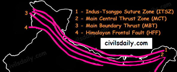
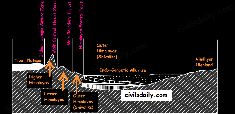
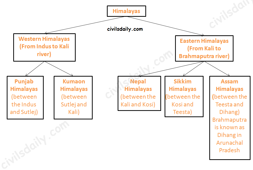
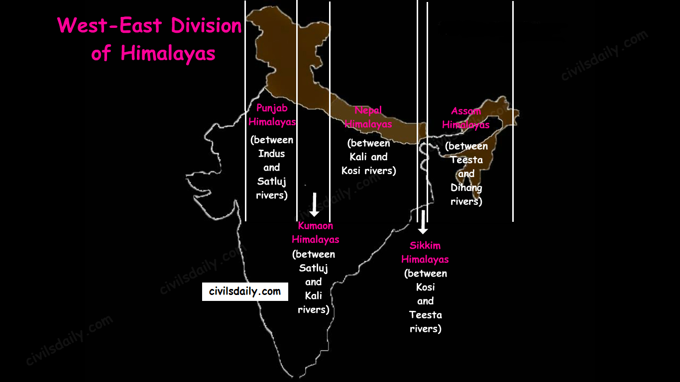
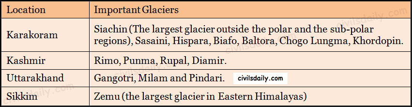
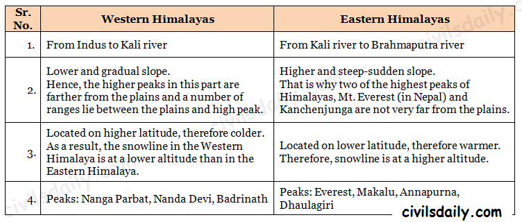

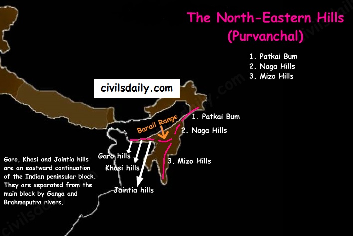
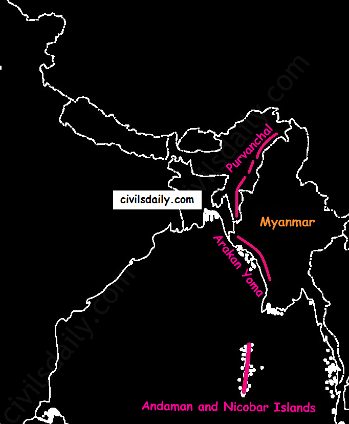
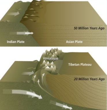
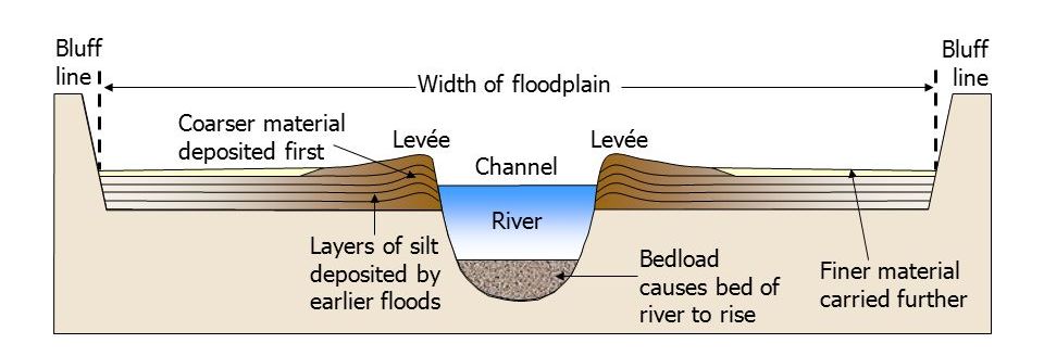
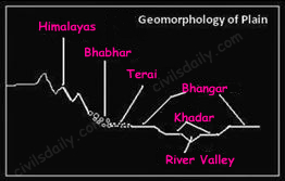
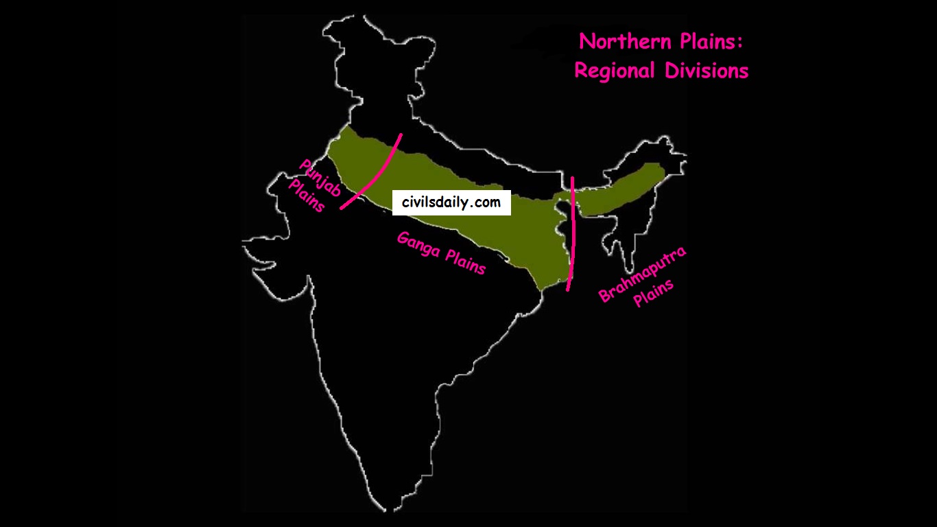
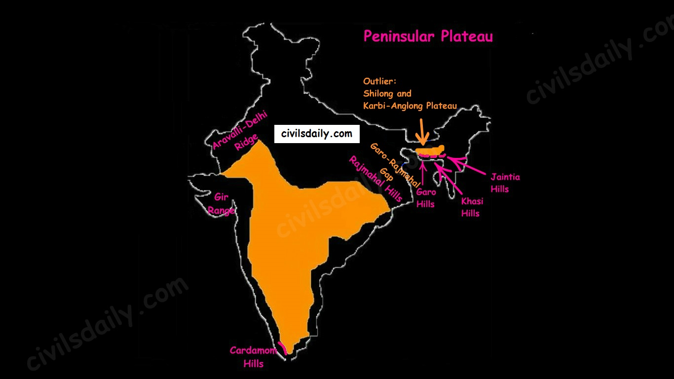
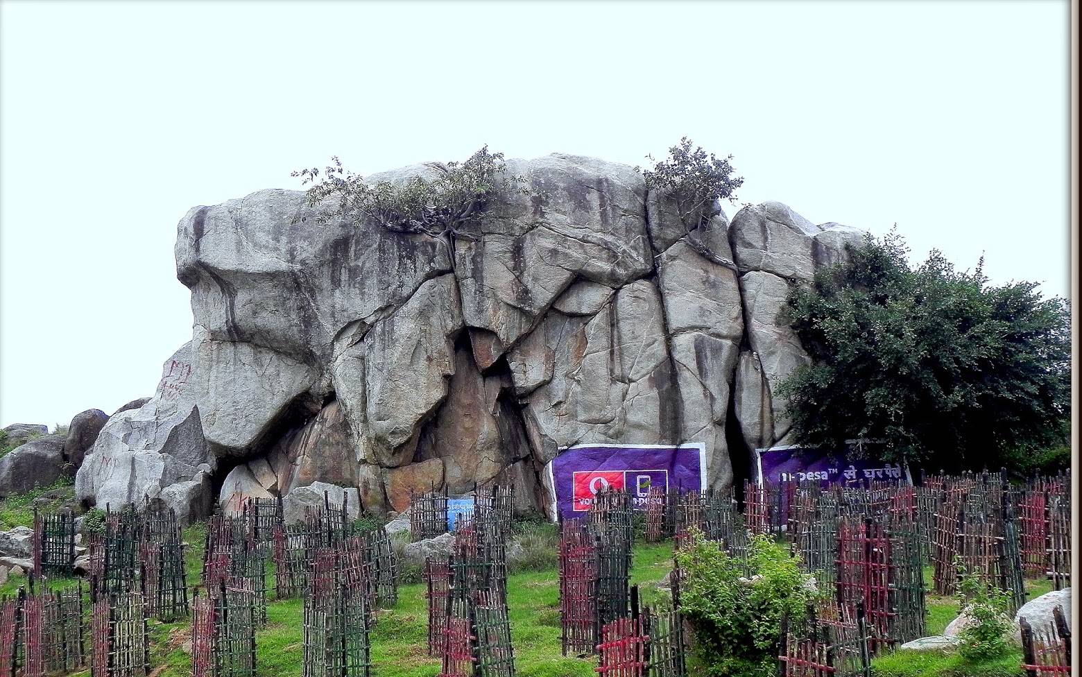
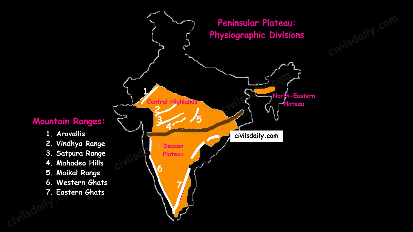
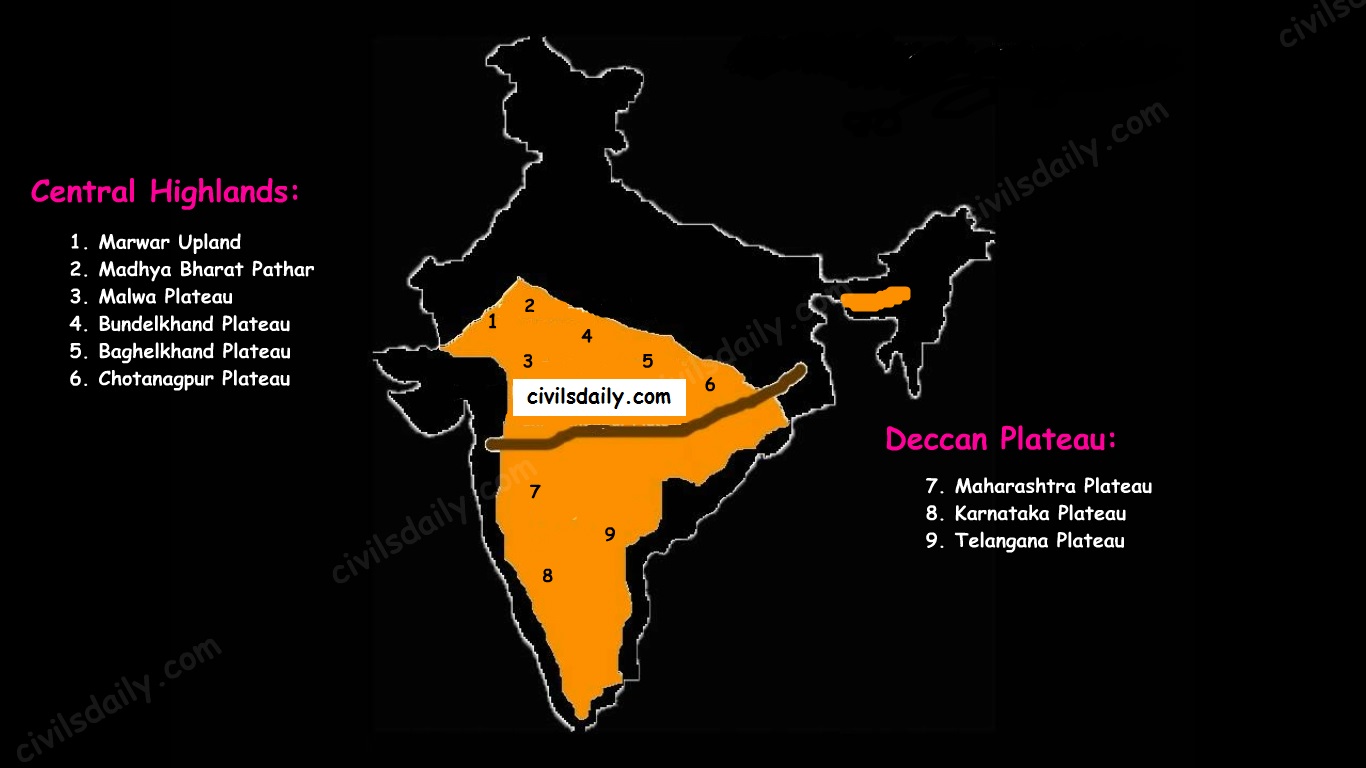
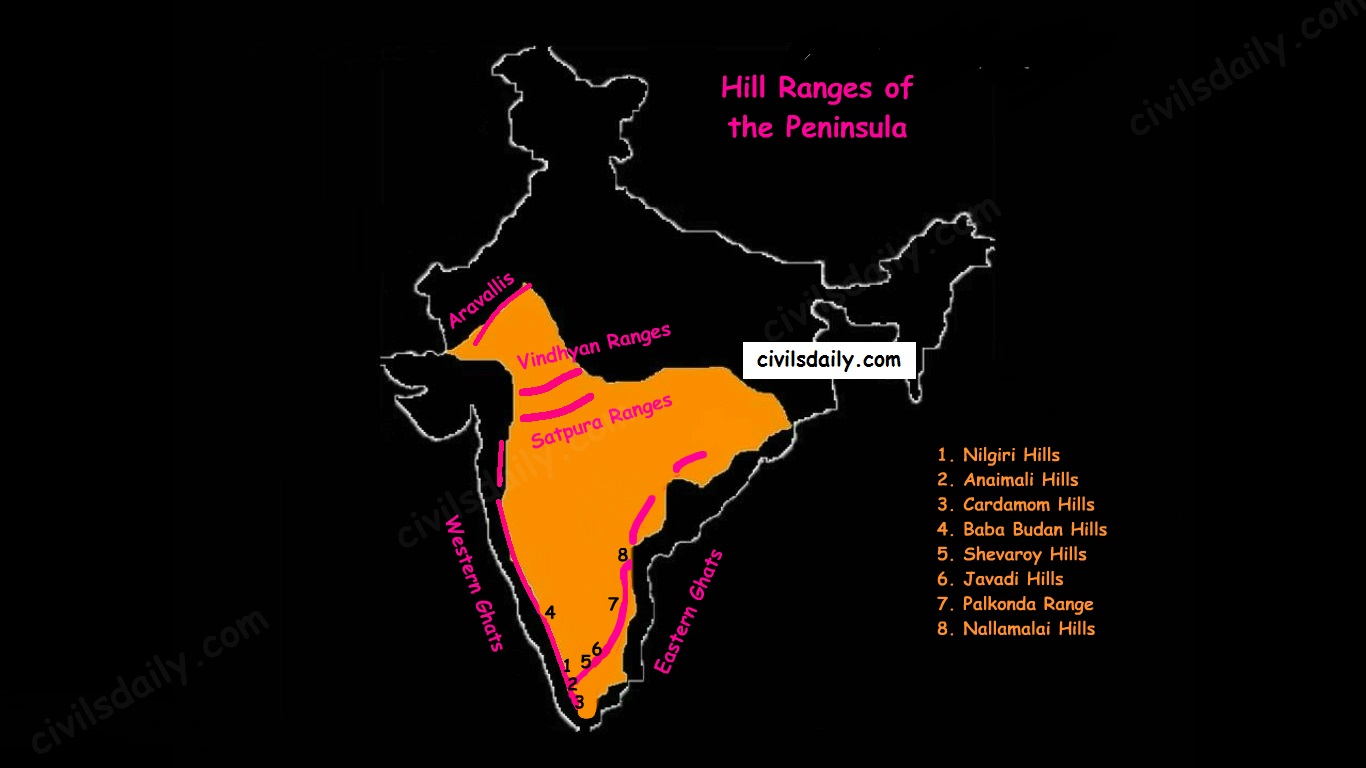
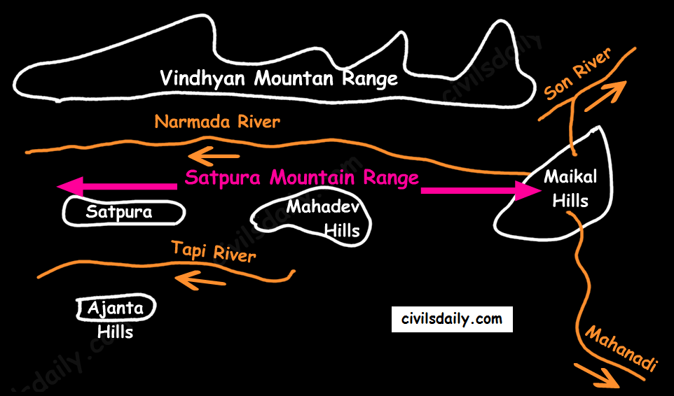
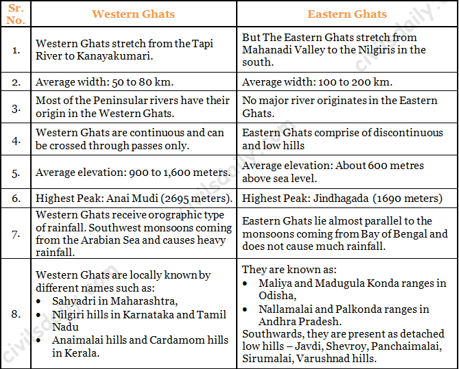
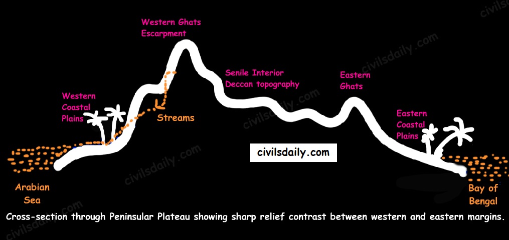
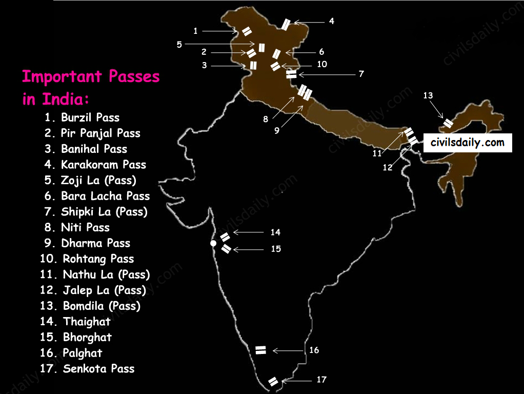
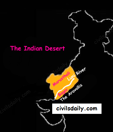
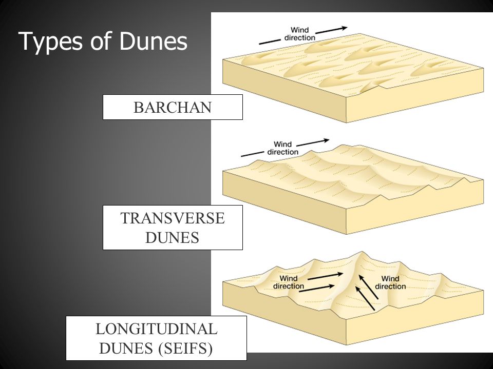
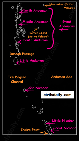
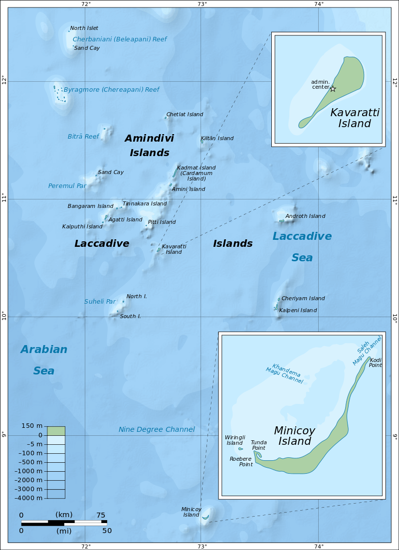


![MEETING LINK INSIDE [Starting Today @ 7PM]Target Prelims 2022 – Last 60 days Plan to clear prelims || Free Webinar by Mentors of 400 UPSC-CSE Toppers, Sajal Sir || Limited Slots, Register Now](https://d18x2uyjeekruj.cloudfront.net/wp-content/uploads/2022/04/5_6212758279148274812.jpg)


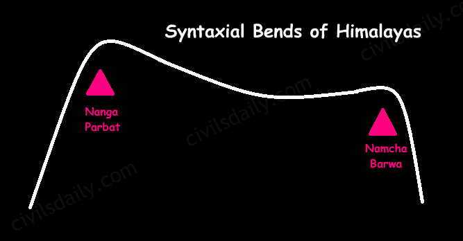
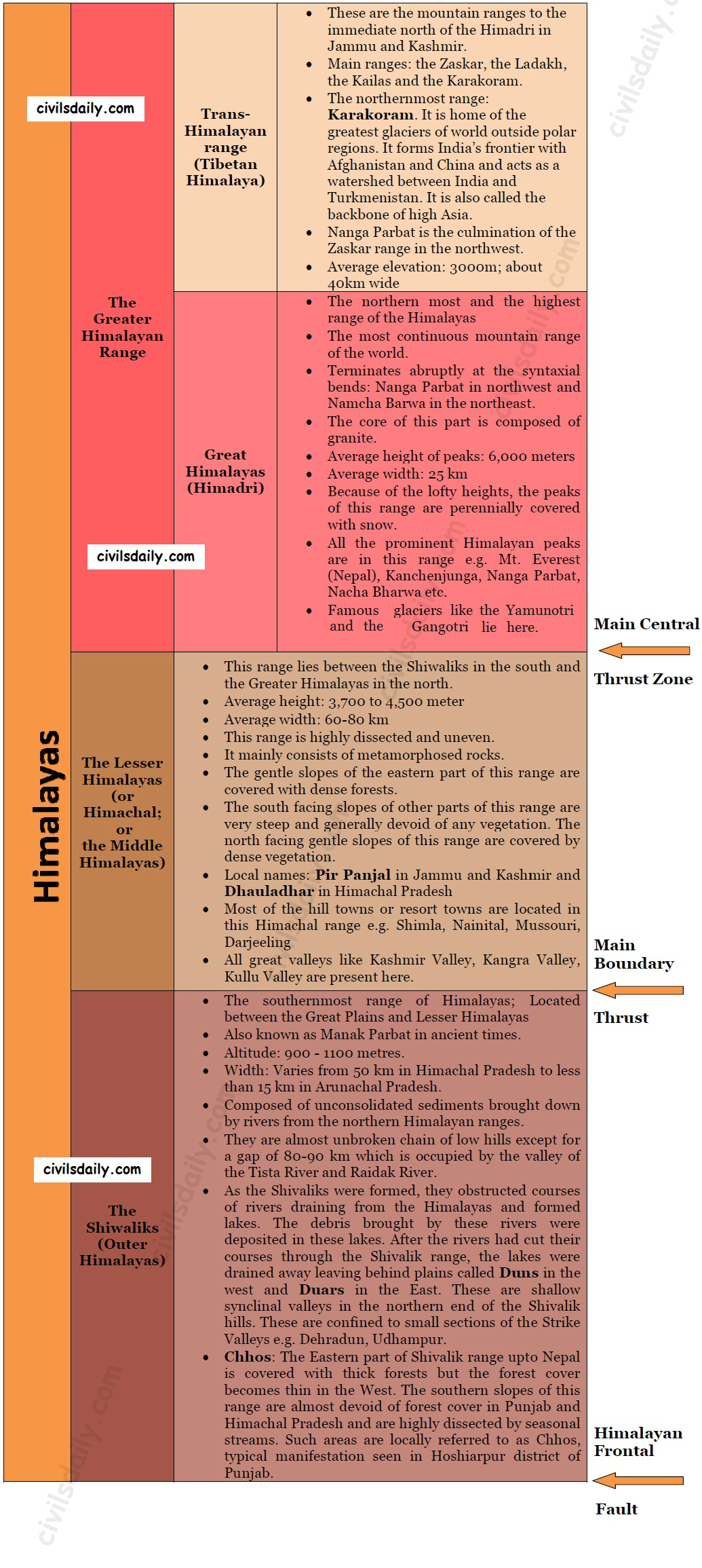
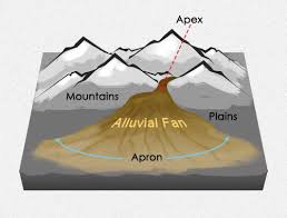
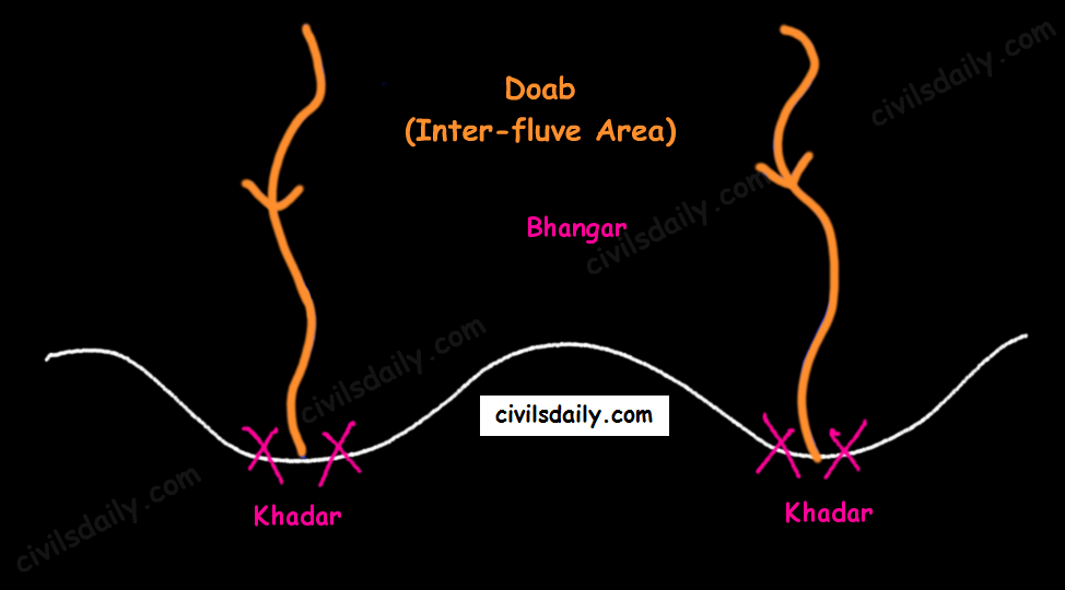