India needs an enabling policy and regulatory environment to tap into the potential of the Second Space Age and its rapidly growing space economy.
What is mean by the Second Space Age?
Commercialization: The Second Space Age refers to the recent era of increased commercialization and private sector involvement in space exploration, which began in the early 2000s.
Emergence of private space companies: This period has been marked by the emergence of private space companies like SpaceX, Blue Origin, and Virgin Galactic, who are investing heavily in space technology and infrastructure.
Today’s space domain has many more actors once dominated by US and USSR: Compared to the First Space Age dominated by the US and the USSR, today’s space domain has many more actors, with a majority being private companies. Private companies account for 90% of global space launches since 2020, and India is no exception
Increasing involvement of non-spacefaring nations: The Second Space Age is also characterized by the increasing involvement of non-spacefaring nations in space exploration and the development of technologies that enable greater access to space for both commercial and scientific purposes.
Exploration: The hope is that this new era will lead to breakthroughs in areas like space tourism, asteroid mining, and Mars colonization, among others.
India’s journey in space began modestly in the 1960s.
Societal objectives: Over the decades, the Indian Space Research Organisation (ISRO) prioritized societal objectives and benefits, such as developing satellite technology for mass communication, remote sensing for weather forecasting, resource mapping of forests, agricultural yields, groundwater and watersheds, fisheries and urban management, and satellite-aided navigation.
Enhanced launch capabilities: ISRO also developed satellite launch capabilities, beginning with the SLV-1 in the 1980s, followed by the PSLV series, which has become its workhorse with over 50 successful launches.
Facts for prelims
Steps taken to promote the space industry in India
Resulting Outcome
Creation of Indian Space Research Organisation (ISRO) in 1969
Establishment of a strong foundation for space research and exploration in India
Launch of Aryabhata satellite in 1975
First satellite successfully launched by India
Establishment of the Vikram Sarabhai Space Centre (VSSC) in 1972
Development of technologies for rocket and satellite launch
Launch of Rohini satellite in 1983
First satellite launched using an Indian-made launch vehicle
Launch of Polar Satellite Launch Vehicle (PSLV) in 1993
Capability to launch smaller satellites into orbit
Launch of Geosynchronous Satellite Launch Vehicle (GSLV) in 2001
Capability to launch larger and heavier satellites into orbit
Successful Mars Orbiter Mission (MOM) in 2014
India became the first country to successfully launch a spacecraft to Mars in its first attempt
Formation of NewSpace India Limited (NSIL) in 2019
Increased involvement of private sector in space activities and commercialization of space technologies
Announcement of Gaganyaan mission in 2018
Development of human spaceflight capabilities in India
India’s Space Potential
Economy and employment: India’s space economy, estimated at $9.6 billion in 2020, is expected to be $13 billion by 2025. However, with an enabling policy and regulatory environment, the Indian space industry could exceed $60 billion by 2030, directly creating more than two lakh jobs.
Downstream activities: Downstream activities such as satellite services and associated ground segment are dominant, accounting for over 70% of India’s space economy.
Media and entertainment segment: Media and entertainment account for 26% of India’s space economy, with consumer and retail services accounting for another 21%.
The Growing Role of the Private Sector
Increasing space start ups: The Indian private sector is responding to the demands of the Second Space Age, with over 100 space start-ups today. From less than $3 million in 2018, investment in the sector has doubled in 2019 and crossed $65 million in 2021.
Potential of multiplier effect on economy: The sector is poised for take-off, as a transformative growth multiplier like the IT industry did for the national economy in the 1990s.
Way ahead: Creating an Enabling Environment
ISRO needs to focus on research and collaborate with the Indian private sector, which has different needs and demands.
To create an enabling environment for the private sector, India needs a space activity act that provides legal grounding, sets up a regulatory authority, and enables venture capital funding into the Indian space start-up industry.
Although a series of policy papers have been circulated in recent years, legislation is needed to provide legal backing and create an enabling environment for private sector growth.
Conclusion
India’s space industry has enormous potential, but realizing it requires an enabling policy and regulatory environment that encourages private sector growth. With a space activity act that provides legal backing, sets up a regulatory authority, and enables venture capital funding, India can take advantage of the Second Space Age and become a major player in the global space economy.
Mains Question
Q. What do you understand by mean Second Space Age? Highlight potential of India’s space industry and growing role of private sector
This Spotlight is a part of our Mission Nikaalo Prelims-2023.
You can check the broad timetable of Nikaalo Prelims here
Session Details
YouTube LIVE with Parth sir – 1 PM – Prelims Spotlight Session
Evening 04 PM – Daily Mini Tests
Join our Official telegram channel for Study material and Daily Sessions Here
10th Apr 2023
Important Seas and Mountain Ranges in the World
Tasman Sea
The Tasman Sea is a marginal sea of the South Pacific Ocean, situated between Australia and New Zealand. It measures about 2,000 kilometres (1,200 mi) across and about 2,800 kilometres (1,700 mi) from north to south. The sea was named after the Dutch explorer Abel Janszoon Tasman, who was the first recorded European to encounter New Zealand and Tasmania. The British explorer Captain James Cook later extensively navigated the Tasman Sea in the 1770s as part of his first voyage of exploration.
Persian Gulf
This inland sea of some 251,000 square kilometres (96,912 sq mi) is connected to the Gulf of Oman in the east by the Strait of Hormuz; and its western end is marked by the major river delta of the Shatt al-Arab, which carries the waters of the Euphrates and the Tigris. Its length is 989 kilometres (615 miles), with Iran covering most of the northern coast and Saudi Arabia most of the southern coast. The Persian Gulf is about 56 km (35 mi) wide at its narrowest, in the Strait of Hormuz. The waters are overall very shallow, with a maximum depth of 90 metres (295 feet) and an average depth of 50 metres (164 feet).
Countries with a coastline on the Persian Gulf are (clockwise, from the north): Iran; Oman’s exclave Musandam; the United Arab Emirates; Saudi Arabia; Qatar, on a peninsula off the Saudi coast; Bahrain, on an island; Kuwait; and Iraq in the northwest. Various small islands also lie within the Persian Gulf, some of which are the subject of territorial disputes between the states of the region.
Mediterranean Sea The Mediterranean Sea is a sea connected to the Atlantic Ocean, surrounded by the Mediterranean Basin and almost completely enclosed by land: on the north by Southern Europe and Anatolia, on the south by North Africa, and on the east by the Levant. The sea is sometimes considered a part of the Atlantic Ocean, although it is usually identified as a separate body of water.
The countries with coastlines on the Mediterranean Sea are
Albania
Algeria
Bosnia and Herzegovina
Croatia
Cyprus
Egypt
France
Greece
Israel
Italy
Lebanon
Libya
Malta
Morocco
Monaco
Montenegro
Slovenia
Spain
Syria
Tunisia
Tukey
In addition, the Gaza Strip (“Palestine” has been associated with the geographical area that currently covers the State of Israel, the West Bank and the Gaza Strip) and the British Overseas Territories of Gibraltar and Akrotiri and Dhekelia have coastlines on the sea.
Black Sea
The Black Sea is a marginal sea of the Atlantic Ocean. It has an area of 436,400 km2 (168,500 sq mi) (not including the Sea of Azov). The roughly oval-shaped Black Sea occupies a large basin strategically situated at the southeastern extremity of Europe but connected to the distant waters of the Atlantic Ocean by the Bosporus (which emerges from the sea’s southwestern corner), the Sea of Marmara, the Dardanelles, the Aegean Sea, and the Mediterranean Sea.
Countries bordering the Black Sea are-
Ukraine
Russia
Georgia
Turkey
Bulgaria
Romania
Caspian Sea
The Caspian Sea is the largest enclosed inland body of water on Earth by area, variously classed as the world’s largest lake or a full-fledged sea. It is in an endorheic basin (a basin without outflows) located between Europe and Asia.
The Caspian Sea is bordered on the northwest by Russia, on the northeast by Kazakhstan, on the west by Azerbaijan, on the southeast by Turkmenistan, and on the south by Iran. It is classified as both a sea and a lake, and it is the largest enclosed inland body of water in the world.
Azerbaijan
Iran
Kazakhstan
Russia
Turkmenistan
Red Sea
The Red Sea (also the Erythraean Sea) is a seawater inlet of the Indian Ocean, lying between Africa and Asia. The connection to the ocean is in the south through the Bab el Mandeb strait and the Gulf of Aden. To the north lie the Sinai Peninsula, the Gulf of Aqaba, and the Gulf of Suez (leading to the Suez Canal). The sea is underlain by the Red Sea Rift which is part of the Great Rift Valley.
The salinity of the Red Sea is greater than the world average, approximately 4 percent. This is due to several factors:
Lack of significant rivers or streams draining into the sea.
Limited connection with the Indian Ocean, which has lower water salinity.
High rate of evaporation and very little precipitation.
The six countries bordering the Red Sea proper are:
Eastern shore:
Saudi Arabia
Yemen
Western shore:
Egypt
Sudan
Eritrea
Djibouti
Aral Sea
The Aral Sea was an endorheic lake lying between Kazakhstan (Aktobe and Kyzylorda Regions) in the north and Uzbekistan (Karakalpakstan autonomous region) in the south. The name roughly translates as “Sea of Islands”, referring to over 1,100 islands that once dotted its waters; in the Turkic languages aral means “island, archipelago”.
South China Sea
The South China Sea is a marginal sea that is part of the Pacific Ocean, encompassing an area from the Karimata and Malacca Straits to the Strait of Taiwan of around 3,500,000 square kilometres (1,400,000 sq mi). The area’s importance largely results from one-third of the world’s shipping sailing through its waters and that it is believed to hold huge oil and gas reserves beneath its seabed.
It is located
south of China;
east of Vietnam and Cambodia;
northwest of the Philippines;
east of the Malay peninsula and Sumatra, up to the Strait of Malacca in the western, and
north of the Bangka–Belitung Islands and Borneo
Ross sea
The Ross Sea is a deep bay of the Southern Ocean in Antarctica, between Victoria Land and Marie Byrd Land. It derives its name from the British explorer James Ross who visited this area in 1841. To the west of the sea lies Ross Island and to the east Roosevelt Island, while the southernmost part is covered by the Ross Ice Shelf, and is about 200 miles (320 km) from the South Pole.
Weddel sea
The Weddell Sea is part of the Southern Ocean and contains the Weddell Gyre. Its land boundaries are defined by the bay formed from the coasts of Coats Land and the Antarctic Peninsula. The easternmost point is Cape Norvegia at Princess Martha Coast, Queen Maud Land. To the east of Cape Norvegia is the King Haakon VII Sea. Much of the southern part of the sea is covered by a permanent, massive ice shelf field, the Filchner-Ronne Ice Shelf . The sea is named after the Scottish sailor James Weddell, who entered the sea in 1823 and originally named it after King George IV; it was renamed in Weddell’s honour in 1900.
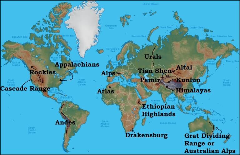
Mountain Ranges
Sr. No.
Mountain Range
Important/Highest Peaks
Location
Description
1
Rocky Mountains
Mt. Elbert (highest peak in the Rockies)
North America
It is one of the longest fold mountains in the world and extends from Canada to Western US (New Mexico State)
2
Appalachian Mountains
Mt. Mitchell, North Carolina, US (highest peak of Appalachian Mountains)
North America
It is a fold mountain with rich in mineral resources
3
Alps
Mont Blanc (French –Italian border)
Europe
It is a folded mountain and source for rivers like Danube, Rhine, etc.
4
Sierra Nevada
Mt. Whitney
California, USA
Habitat for many Red Indian tribes
5
Alaska Range
Mt. McKinley
North America
Mt. McKinley highest peak in North America
6
Altai Mountains
Belukha mountain
Central Asia
Young folded mountain which extends from Kazakhstan to northern China.
7
Andes Mountains
Mt. Aconcagua
South America
Longest mountain chain in the world
8
Atlas Mountains
Mt. Toubkal
Northwestern Africa
Young fold mountain spreading over Morocco and Tunisia.
9
Drakensberg Mountains
Mt. Lesotho
South Africa
Young folded mountain
10.
Caucasus Mountain
Mt. Elbrus
Europe
Located between the Black Sea and the Caspian Sea
11.
Ural Mountains
Mt. Narodnaya
Russia
This mountain range act as a boundary between Europe and Asia.
12.
Hindukush Mountains
Mt. Trich Mir
Pakistan and Afghanistan
Folded mountain with rugged topography which makes it difficult for transportation.
13.
Himalayas
Mt. Everest
Asia
Young fold mountains in Asia which separates Indian sub-continent from Asian plains
14.
Arakan Yoma
Mt. Kennedy peak
Myanmar
It extends from north to south direction. Shifting cultivation is practised.
15.
Kunlun Mountains
Mt. Muztag
North of Tibetan plateau and western China
It is one of the young folded mountains.
16.
Vosges
Mt. Grand Ballon
Eastern France, Europe
Famous for the cultivation of grapes and manufacture of wines.
17.
Great Dividing Range
Mt. Kosciuszko
Australia
This range is the source for the rivers Darling and Murray.
Important Straits, Deserts and Volcanoes
Important Volcanoes, Straits and Deserts:
Vezuvias : Italy
Etna : Italy
Stromboli : Italy
Barren : India (Andaman Nicobar)
Kilimancharo : Tanzania
Krakathove : Indonesia
Pina thubo : Philippense
Ring of fire : Pacific
Lighthouse of the Pacific : Ezalko
Lighthouse of the Mediteranian : Stromboli
Important Deserts:
Fozil desert : Kalahari
Little Sahara : Australia
Death desert : Thakkala Makkan
Painted desert : North America
Coldest desert : Gobi
Warmest desert : Sahara
Driest desert : Attakkama
Great Indian desert : Thar
Roob Asavali : Asia
Attakkama : South America
Sahara : Africa
Kalahari : Africa
Nameeb : Nameebia
Great Sandy : Australia
Great Victoria : Australia
Thakkala Makkan : China
Sahel : China
Thar : India
The following table lists the major straits in the world:
Strait
Contiguous Landmass
Joining Seas/Water Bodies
Formosa Strait
China and Taiwan
The South China Sea and the East China Sea
Strait of Tartary
Russia (East Russia-Sakhalin Islands)
Sea of Okhotsk and the Sea of Japan
Yucatan Strait
Mexico and Cuba
The Gulf of Mexico and the Caribbean Sea
Mesina Strait
Italy and Sicily
The Tyrrhenian Sea and the Ionian Sea, within the central Mediterranean
Otranto Strait
Italy and Albania
Adriatic Sea & Ionian Sea
Cook Strait
New Zealand
The Tasman Sea and South Pacific Ocean
Mozambique Channel
Mozambique and Madagascar
Indian Ocean
North Channel
Ireland and Scotland
Irish Sea and Atlantic Ocean
Hormuz Strait
Iran and Oman
The Gulf of Oman and the Persian Gulf
Bab-el-Mandeb
Djibouti, Yemen, and Eritrea of the Somali Peninsula
The Gulf of Aden and the Red Sea
Ten Degree Channel
Car Nicobar Islands and Little Andaman
Andaman Sea and the Bay of Bengal
Sunda Strait
Java island of Indonesia with its Sumatra island.
Java Sea and the Indian Ocean
Florida Strait
Cuba and the USA
Gulf of Mexico and the Atlantic Ocean
Bering Strait
Asia from America
The Arctic Ocean and East Pacific ocean
Strait of Gibraltar
Spain and Morocco
The Atlantic Ocean and the Mediterranean Sea
Korea Strait
Japan and South Korea
The East China Sea and the Sea of Japan
Strait of Malacca
Malaysia and Sumatra
The Pacific Ocean to the east with the Indian Ocean to the west
Bonifacio Strait
Corsica island of France and Sardinia islands of Italy
The Tyrrhenian Sea and the Mediterranean Sea
Palk Strait
India and Sri Lanka
The Bay of Bengal in the northeast with the Palk Bay/Arabian Sea in the southwest
Prime Minister visited Bandipur Tiger Reserve in Karnataka and released the latest tiger census data marking the completion of 50 years of ‘Project Tiger’.
PM also launched the International Big Cats Alliance (IBCA). IBCA will focus on protection and conservation of seven major big cats of the world -Tiger, Lion, Leopard, Snow Leopard, Puma, Jaguar and Cheetah, with membership of the range countries.
About Project Tiger
Launched from Jim Corbett National Park, Uttarakhand, the project is an ongoing scheme of the Ministry of Environment, Forest and Climate Change (MoEFCC).
The centrally sponsored scheme is applicable in nine reserves of different States, namely Assam, Bihar, Karnataka, Madhya Pradesh, Maharashtra, Odisha, Rajasthan, Uttar Pradesh, and West Bengal.
Project Tiger has been converted into a statutory authority, National Tiger Conservation Authority (NTCA) by providing enabling provisions in the Wild Life (Protection) Act, 1972 through an amendment, via Wild Life (Protection) Amendment Act, 2006. The NTCA addresses ecological and administrative concerns for conserving tigers. It provides a statutory basis for the protection of tiger reserves and provides strengthened institutional mechanisms for the protection of ecologically sensitive areas and endangered species.
Purpose of Project Tiger
The tiger is a unique animal that plays a pivotal role in the health and diversity of an ecosystem.
Predation balance: It is a top predator which is at the apex of the food chain.
Regulation of herbivores: It keeps the population of wild ungulates in check, thereby maintaining the balance between prey herbivores and the vegetation upon which they feed.
Ecosystem balance: Therefore, the presence of tigers in the forest is an indicator of the well being of the ecosystem.
Tourism: Apart from the ecological services provided by the animal, the tiger also offers direct use such as attracting tourists, which provide incomes for local communities.
Execution of the Project Tiger
Project Tiger was administered by the NTCA. The overall administration of the project is monitored by a steering committee, which is headed by a director. A field director is appointed for each reserve, who is assisted by a group of field and technical personnel.
Shivalik-Terai Conservation Unit
North-East Conservation Unit
Sunderbans Conservation Unit
Western Ghats Conservation Unit
Eastern Ghats Conservation Unit
Central India Conservation Unit
Sariska Conservation Unit
Kaziranga Conservation Unit
The various tiger reserves were created in the country based on the ‘core-buffer’ strategy:
Core Area: are free of all human activities. It has the legal status of a national park or wildlife sanctuary. It is kept free of biotic disturbances and forestry operations like a collection of minor forest produce, grazing, and other human disturbances are not allowed within.
Buffer Areas: are subjected to ‘conservation-oriented land use’. They comprise forest and non-forest land. It is a multi-purpose use area with twin objectives of providing habitat supplement to spillover population of wild animals from the core conservation unit and providing site-specific co-developmental inputs to surrounding villages for relieving their impact on the core area.
Issues with the Project
Implementation bottlenecks: The efforts were hampered by poaching, as well as debacles and irregularities in Sariska and Namdapha, both of which were reported extensively in the Indian media.
Forest Dwellers Rights: The Forest Rights Act passed by the Indian government in 2006 recognizes the rights of some forest-dwelling communities in forest areas. This has led to controversy over implications of such recognition for tiger conservation.
Man-Animal Conflict: Some have argued that this is problematic as it will increase conflict and opportunities for poaching; some also assert that “tigers and humans cannot co-exist”.
Abuse of Authority: Others argue that this is a limited perspective that overlooks the reality of human-tiger coexistence and the abuse of power by authorities, evicting local people and making them pariahs in their own traditional lands.
Other efforts to save Tigers
India is home to 70 percent of the global tiger population. Therefore, the country has an important role to play in tiger conservation.
[1] Project Tiger
(discussed above)
[2] CITES (Convention on International Trade in Endangered Species of Wild Fauna and Flora)
Besides protecting tiger territory, other measures being taken to save the tiger include: curbing wildlife trade through international agreements.
CITES is an international agreement between governments aimed at ensuring that international trade in specimens of wild animals and plants, including tigers, does not threaten their survival. India ratified this treaty in 1976.
[3] Global Tiger Forum and Tiger Range Countries
Established in 1994, the Global Tiger Forum is the only inter-governmental body for tiger conservation.
Its membership includes seven tiger range countries: Bangladesh, Bhutan, India, Cambodia, Myanmar, Nepal and Vietnam.
[4] CA|TS
14 tiger reserves have been accredited under CA|TS (Conservation Assured | Tiger Standards) categories.
The CA|TS is a set of criteria that examines the management of tiger sites to gauge the success rates of tiger conservation.
[5] St. Petersburg Declaration
This resolution was adopted In November 2010, by the leaders of 13 tiger range countries (TRCs) assembled at an International Tiger Forum in St. Petersburg, Russia
It aimed at promoting a global system to protect the natural habitat of tigers and raise awareness among people on white tiger conservation.
[6] Various NGOs
International NGO members consist of World Wildlife Fund, International Fund for Animal Welfare (IFAW), and TRAFFIC.
Several national NGOs from India and Nepal are also members.
Success of these efforts
India’s tiger population rose by 200 in the past four years to reach 3,167 in 2022, the latest tiger census data revealed.
According to the data, the tiger population was 1,411 in 2006, 1,706 in 2010, 2,226 in 2014, 2,967 in 2018 and 3,167 in 2022.
The four-year tiger census report, Status of Tigers in India, 2018 shows numbers of the big cat have increased across all landscapes.
The total count has risen to 2,967 from 2,226 in 2014 — an increase of 741 individuals (aged more than one year), or 33%, in four years.
At present, India has around 75% of tiger population and its source areas amongst the 13 tiger range countries in the world.
2.24% of country’s geographical area is spread out in 51 tiger reserves in 18 States.
Significance of Tiger Conservation
Tiger conservation is necessary for several reasons:
Ecological balance: Tigers are apex predators and help maintain the ecological balance of the ecosystem they inhabit. They help regulate the populations of prey species and maintain a balance in the food chain.
Biodiversity: Tigers are an umbrella species, meaning that their conservation can lead to the conservation of other species in their ecosystem. The presence of tigers indicates a healthy ecosystem with a diverse range of flora and fauna.
Economic benefits: Tiger conservation can provide economic benefits to local communities through eco-tourism. It can create job opportunities and generate revenue for the local economy.
Cultural significance: Tigers hold cultural significance in many societies and are considered to be symbols of power, strength, and courage.
Climate change: Tigers are indicators of the health of forests, which play a crucial role in mitigating climate change. The conservation of tigers and their habitat can help in reducing carbon emissions and combating climate change.
Various threats to Tigers
Despite measures being initiated to protect wild tigers, habitat loss and poaching continue to pose a threat to the animal’s survival.
Tiger parts are used in traditional Chinese medicines, tiger skin is used for decorative and medicinal purposes and tiger bones are again used for medicinal purposes for curing body pain, et al.
Between 2000 and 2014, TRAFFIC’s research found that parts of a minimum of 1,590 Tigers were seized in Tiger range States, an average of two Tigers per week.
Other existential threats to tigers
Poaching: Illegal hunting and poaching of tigers for their body parts and skins remains a significant threat to their survival.
Man-Animal conflict: This largely seems a normal phenomenon in India. We broadly remember the case of Tigress Avni which was finally shot dead by the forest officials in Maharashtra.
Illegal wildlife trade: The illegal trade in tiger parts, skins, and bones remains a significant threat to the survival of tigers in India and around the world.
Shrinking habitat: This often leads to territorial conflicts among the Tigers.
Issues with Tourism: Excess of tourist activities is problematic for animals. Frequent visits in reserved forests areas disrupt them to move freely for their prey.
Climate Change: The effects of climate change and floods are a major problem. The latest study by WWF shows that Sundarban which is one of the biggest home of tigers in India would sink entirely in 2070.
Way forward
The process of tiger conservation should be more dynamic and compatible with the future possibilities of climatic changes as well.
The Forest Department and the Central government can collaborate to protect the natural corridors to ensure the free movement of the tigers for better food resources.
Campaigns such as ‘Save the Tiger’ are recommended as effective measures to make people across the country and globe aware of the significance of conserving tiger species.
Sensitization of local communities against poaching is also a crucial measure in this regard.
We have to make the environment and development co-exist and go hand in hand by planning our future developmental goals in such a manner that our environmental goals are not compromised.
The Union government is gearing up to constitute the Sixteenth Finance Commission in November this year to recommend the formula for sharing revenues between the Centre and the States for the five-year period beginning 2026-27.
What is the Finance Commission?
The Finance Commission (FC) was established by the President of India in 1951 under Article 280 of the Indian Constitution.
It was formed to define the financial relations between the central government of India and the individual state governments.
The Finance Commission (Miscellaneous Provisions) Act, 1951 additionally defines the terms of qualification, appointment and disqualification, the term, eligibility and powers of the Finance Commission.
As per the Constitution, the FC is appointed every five years and consists of a chairman and four other members.
Since the institution of the First FC, stark changes in the macroeconomic situation of the Indian economy have led to major changes in the FC’s recommendations over the years.
Constitutional Provisions
Several provisions to bridge the fiscal gap between the Centre and the States were already enshrined in the Constitution of India, including Article 268, which facilitates levy of duties by the Centre but equips the States to collect and retain the same.
Article 280 of the Indian Constitution defines the scope of the commission:
Who will constitute: The President will constitute a finance commission within two years from the commencement of the Constitution and thereafter at the end of every fifth year or earlier, as the deemed necessary by him/her, which shall include a chairman and four other members.
Qualifications: Parliament may by law determine the requisite qualifications for appointment as members of the commission and the procedure of selection.
Terms of references: The commission is constituted to make recommendations to the president about the distribution of the net proceeds of taxes between the Union and States and also the allocation of the same among the States themselves. It is also under the ambit of the finance commission to define the financial relations between the Union and the States. They also deal with the devolution of unplanned revenue resources.
Important functions
Devolution of taxes: Distribution of net proceeds of taxes between Center and the States, to be divided as per their respective contributions to the taxes.
Grants-in-aid: Determine factors governing Grants-in-Aid to the states and the magnitude of the same.
Augment states fund: To make recommendations to the president as to the measures needed to augment the Fund of a State to supplement the resources of the panchayats and municipalities in the state on the basis of the recommendations made by the finance committee of the state.
Any financial function: Any other matter related to it by the president in the interest of sound finance.
Members of the Finance Commission
The Finance Commission (Miscellaneous Provisions) Act, 1951 was passed to give a structured format to the finance commission and to bring it to par with world standards.
It laid down rules for the qualification and disqualification of members of the commission, and for their appointment, term, eligibility and powers.
The Chairman of a finance commission is selected from people with experience of public affairs. The other four members are selected from people who:
Are, or have been, or are qualified, as judges of a high court,
Have knowledge of government finances or accounts, or
Have had experience in administration and financial expertise; or
Have special knowledge of economics
Key challenges ahead for 16th FC
Overlap with GST Council: A key new challenge for the 16th FC would be the co-existence of another permanent constitutional body, the GST Council.
Conflict of interest: The GST Council’s decisions on tax rate changes could alter the revenue calculations made by the Commission for sharing fiscal resources.
Feasibility of recommendations: Centre usually takes the Commission’s recommendations on States’ share of tax devolution and the trajectory for fiscal targets into account, and ignores most other suggestions.
Major outstanding recommendations
Creating a Fiscal Council: The 15th FC has suggested creating a Fiscal Council where Centre and States collectively work out India’s macro-fiscal management challenges, but the government has signalled there is no need for it, he pointed out.
Creating a non-lapsable fund for internal security: The centre accepted to set up a non-lapsable fund for internal security and defense ‘in principle’, its implementation still has to be worked out.
Former Sikkim CM claimed that the Sikkimese people feel betrayed as Article 371F, which guarantees special provisions for Sikkim, was “violated”.
What is Article 371F?
Article 371F is a special provision in the Constitution of India that was created to provide for the unique status of Sikkim, a state located in the northeastern part of India.
Sikkim was an independent kingdom until 1975, when it became the 22nd state of India.
Article 371F was included in the Constitution to ensure that Sikkim’s distinct identity and cultural heritage were protected and preserved after its merger with India.
Special provisions for Sikkim
Under Article 371F, Sikkim has been granted several special provisions that are not available to other states in India. Some of the key provisions of Article 371F are:
Protection of Sikkimese people: Only the descendants of Sikkim subjects (those who lived in the state before its merger with India) whose names were mentioned in the 1961 register are considered Sikkimese and are entitled to certain benefits, such as the right to own land and get state government jobs. They are also exempted from paying income tax.
Legislative powers: The Governor of Sikkim has special powers with respect to the Sikkim Legislative Assembly, including the power to nominate one member to the Assembly and the power to give his or her assent to certain bills.
Constitutional safeguards: Certain constitutional safeguards have been provided to the people of Sikkim to protect their distinct identity and cultural heritage.
Formation of Committees: The Central Government has the power to appoint a committee of experts to advise on matters related to Sikkim, and the State Government can also appoint committees to examine issues related to the protection of Sikkim’s unique identity.
Why in news?
The Financial Bill, 2023 redefined Sikkimese as any Indian citizen domiciled in Sikkim, which would extend these benefits to a broader population.
This move is seen as a violation of Article 371F, which was the basis for Sikkim’s merger with India in 1975.
Concerns highlighted
The leader claimed that the people of Sikkim feel betrayed by the violation of Article 371F.
He alleged that Sikkim has become a hotbed for political violence.
He claimed that unrest in a sensitive border state like Sikkim is not good for national security.
Back2Basics: Article 371
It is a provision in the Constitution of India that grants special provisions and autonomy to certain states in India.
It is a set of temporary and transitional provisions that were included in the Constitution to address the specific needs and aspirations of various regions and communities in the country.
The provisions of Article 371 differ from state to state, depending on the specific needs and demands of the region. For instance:
Maharashtra and Gujarat: Article 371 provides for special provisions for the states of Maharashtra and Gujarat, which grants certain rights and privileges to the people of the Marathi-speaking areas of Maharashtra and the Gujarati-speaking areas of Gujarat.
Nagaland: Article 371A provides for special provisions and autonomy for the state of Nagaland. It grants the Nagaland Legislative Assembly special powers with respect to lawmaking, and prohibits outsiders from acquiring land in the state.
Assam: Article 371B provides for special provisions for the state of Assam, which includes the establishment of a regional council for the state and grants the council certain legislative and executive powers.
Manipur: Article 371C provides for special provisions for the state of Manipur. It gives the Manipur Legislative Assembly the power to enact laws related to land, forests, and minerals, and also provides for the protection of the rights of the hill tribes in the state.
Andhra Pradesh: Article 371D provides for the establishment of a special committee to oversee the development of backward regions in the state of Andhra Pradesh.
The provisions are aimed at promoting the development and welfare of the people in these states, while preserving their unique cultural and linguistic identity.
Scientists at the National Geophysical Research Institute (NGRI) in Hyderabad have discovered the presence of rare-earth elements (REEs) in Anantapur district, Andhra Pradesh.
What are Rare-Earth Elements?
Rare-earth elements (REEs) are a group of 17 elements, including lanthanum, cerium, praseodymium, neodymium, yttrium, hafnium, tantalum, niobium, zirconium, and scandium.
These elements are widely used in modern electronics, such as smartphones, computers, jet aircraft, and other products, due to their unique magnetic, optical, and catalytic properties.
These elements are crucial components in various electronic devices and have industrial applications in sectors like imaging, aerospace, and defense.
SHORE Project and discovery of REEs
The discovery was part of a study funded by the Council of Scientific and Industrial Research (CSIR) under a project called ‘Shallow subsurface imaging Of India for Resource Exploration’ (SHORE).
NGRI scientists found enriched quantities of REEs in “whole rock analyses”.
Drilling for at least a kilometer deep will help ascertain the consistency of the elements’ presence underground.
Significance of the discovery
The discovery of REEs in Anantapur district is significant as these elements are in high demand worldwide, and their supply is limited.
REEs have become a subject of geopolitical concern due to their increasing demand and limited supply.
China is currently the world’s largest producer and exporter of rare-earth elements (REEs), accounting for more than 80% of global production.
The country has significant reserves of REEs and has invested heavily in mining and processing infrastructure.
India has given the final approval to build its biggest scientific facility, Laser Interferometer Gravitational-Wave Observatory (LIGO), in the Hingoli district of Maharashtra. The facility will join the global project to detect and study gravitational waves.
Gravitation and General Theory of Relativity
Newton’s law of gravitation, proposed by Sir Isaac Newton in the 17th century, explains that the force that makes an object fall to the ground is also responsible for making heavenly bodies go around in their orbits.
However, the theory did not explain the existence of an attractive force between any two bodies or the instantaneous propagation of the gravitational force over large distances.
In 1915, Albert Einstein proposed the General Theory of Relativity, which altered our understanding of gravitation. Einstein proposed that space-time interacted with matter, was influenced by it, and in turn, and influenced events.
The curvature in space-time produced by matter was the reason other smaller bodies in the vicinity felt the gravitational pull.
General Relativity also predicted that moving objects would generate gravitational waves in space-time.
Ripples in spacetime caused by violent and energetic events in the universe
Location
Livingston, Louisiana and Hanford, Washington
Detector
Michelson interferometer
Function
Measure changes in length caused by passing gravitational waves
Benefits
Improving our understanding of the universe and its origins
Discovery
Detected gravitational waves for the first time in 2015
Significance
Confirmed a prediction made by Albert Einstein’s theory of general relativity
Field
Gravitational wave astronomy
Discoveries
Many exciting discoveries about the nature of the universe
About LIGO-India
LIGO-India will be the fifth node of this international network of gravitational wave observatories, and possibly the last.
The instrument is so sensitive that it can easily get influenced by events like earthquakes, landslides, or even the movement of trucks, and produce a false reading.
That is why multiple observatories are needed to revalidate the signals.
India’s involvement in LIGO is crucial to demonstrating its intent and capability to pull-off complex science projects independently.
Significance
The detection and study of gravitational waves could help in understanding the universe’s structure, the origin of the universe, and the functioning of black holes.
The LIGO project also has huge spin-off benefits for India’s science and technology sector.
Physicists in Japan have discovered a new isotope of uranium, with atomic number 92 and mass number 241.
Uranium
Uranium is a naturally occurring chemical element with the symbol U and atomic number 92.
It is a heavy metal that is radioactive and found in small quantities in rocks and soils worldwide.
Uranium has several isotopes, which are atoms that have the same number of protons but different numbers of neutrons.
Isotopes of Uranium
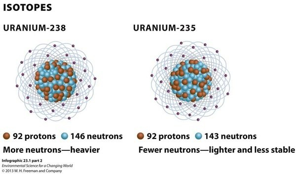
The most common isotopes of uranium are uranium-238 and uranium-235.
Uranium-238: It is the most abundant isotope of uranium, accounting for over 99% of natural uranium. It has 92 protons and 146 neutrons in its nucleus. It is not fissile, which means it cannot sustain a nuclear chain reaction. However, it is fertile, which means it can absorb neutrons and undergo radioactive decay to produce other isotopes such as plutonium-239, which is fissile.
Uranium-235: It is the second most abundant isotope of uranium, accounting for less than 1% of natural uranium. It has 92 protons and 143 neutrons in its nucleus. Unlike uranium-238, it is fissile, which means it can sustain a nuclear chain reaction. It is used as fuel in nuclear reactors and as the primary material for nuclear weapons.
How are isotopes created?
Isotopes can be created through natural processes or artificial processes in a laboratory.
Isotopes are created through natural processes such as radioactive decay, cosmic ray interactions, and nuclear fusion reactions in stars.
For example, carbon-14 is created in the Earth’s upper atmosphere when cosmic rays interact with nitrogen atoms.
Isotopes can also be created artificially through nuclear reactions.
This involves bombarding atoms with particles such as protons, neutrons, or alpha particles, which can change the number of protons and/or neutrons in the nucleus.
How uranium-241 was found?
To find uranium-241, the researchers accelerated uranium-238 nuclei into plutonium-198 nuclei using the KEK Isotope Separation System (KISS).
In a process called multinucleon transfer, the two isotopes exchanged protons and neutrons, resulting in nuclear fragments with different isotopes.
The researchers identified uranium-241 and measured the mass of its nucleus using time-of-flight mass spectrometry.
Theoretical calculations suggest that uranium-241 could have a half-life of 40 minutes.
Significance of the discovery
The discovery is significant because it refines our understanding of nuclear physics, particularly the shapes of large nuclei of heavy elements and how often they occur.
This information helps physicists to design models for nuclear power plants and exploding stars.
Also, what are Magic numbers?
There is a particular interest in ‘magic number’ nuclei, which contain a certain number of protons or neutrons that result in a highly stable nucleus.
Lead (82 protons) is the heaviest known ‘magic’ nucleus, and physicists have been trying to find the next element with magic numbers.
The researchers hope to extend their systematic mass measurements towards many neutron-rich isotopes, at least to neutron number 152, where a new ‘magic number’ is expected.
Conclusion
The discovery of the new neutron-rich uranium isotope is a major breakthrough in nuclear physics, as it provides essential information for understanding the behavior of heavy elements.
The researchers’ aim to extend their measurements to other neutron-rich isotopes reflects their commitment to exploring the frontiers of nuclear science and to improve our understanding of the universe.
Discovering new magic number nuclei through these measurements could have practical applications in designing safer and more efficient nuclear power plants and understanding the properties of exploding stars.
Central idea: Indian-American statistician Calyampudi Radhakrishna Rao has been awarded the 2023 International Prize in Statistics, which is considered the Nobel Prize for statistics. He is 102 YO.
Who is C. R. Rao?
R. Rao, is an Indian-American mathematician and statistician.
He is currently professor emeritus at Pennsylvania State University and Research Professor at the University at Buffalo.
Rao has been honoured by numerous colloquia, honorary degrees, and festschrifts and was awarded the US National Medal of Science in 2002.
The American Statistical Association has described him as “a living legend whose work has influenced not just statistics, but has had far reaching implications for fields as varied as economics, genetics, anthropology, geology, national planning, demography, biometry, and medicine.”
The Times of India listed Rao as one of the top 10 Indian scientists of all time.
Rao’s Groundbreaking Paper
The research paper, “Information and accuracy attainable in the estimation of statistical parameters,” was published in 1945 in the Bulletin of the Calcutta Mathematical Society.
The paper provided a lower limit on the variance of an unbiased estimate for a finite sample, which has since become a cornerstone of mathematical statistics.
Key outcomes of his research
Rao’s 1945 paper has three outcomes-
Cramer-Rao inequality: It provides a lower limit on the variance of an unbiased estimate for a finite sample.
Rao-Blackwell Theorem: It provides a method to improve an estimate to an optimal estimate.
Information geometry: It is a new interdisciplinary area called “information geometry,” which integrated principles from differential geometry into statistics, including the concepts of metric, distance, and measure.
The claim of poverty reduction in India during the pandemic year of 2020-21 is contested due to discrepancies in data and survey design. The PLFS data is used to make this claim, and there are recent papers that have come up with divergent claims on trends in poverty, showing both a rapid decline in poverty as well as a sharp increase.
Use of Comparable Estimates
Poverty estimates in India have always been based on consumption estimates from the NSO, particularly based on the consumption expenditure surveys (CES).
The last official poverty estimates were for 2011-12, even though a comparable consumption survey was conducted in 2017-18.
What is Periodic Labour Force Survey (PLFS)?
PLFS is a large-scale household survey conducted by the National Statistical Office (NSO) of India.
It collects data on various aspects of the labour force in India, including employment, unemployment, and labour force participation rates. In addition to these labour force indicators, the PLFS also collects data on consumption expenditure, which can be used to estimate poverty levels.
Issue with PLFS Data
Estimates are not comparable: The PLFS estimates of poverty are not comparable with those from the CES, as the PLFS estimates are based on a single question.
Consumption estimates: The issue of sensitivity of consumption estimates to survey design, the level of aggregation and details has been extensively written about and was at the heart of the Great Indian Poverty Debate of the early 2000s.
Details about consumption expenditure is not just relevant: The sensitivity to the details of questions asked to collect consumption expenditure is not just relevant across different surveys but also across different rounds of the PLFS.
Poverty Trends
The first set of conclusions can be drawn for the period between 2011-12 and 2017-18.
Using the CES based full schedule and the leaked report for 2017-18, a rise in poverty can be seen.
For a similar time period, the single question asked in the earlier rounds of PLFS can be compared with the 2014-15 (72nd round) NSO survey on services and durable goods expenditure which had exactly the same question in the same block with the same instructions making them comparable to estimates from the PLFS from 2017-18 to 2019-20.
These suggest that the poverty headcount ratio was 27 per cent in 2014-15 and rose to 36 per cent in 2017-18, declining to 32 per cent in 2018-19 and remaining at that level in 2019-20.
Unfortunately, for the period during the pandemic (2019-20 to 2020-21) that the PM paper tries to address, it is difficult to say what happened based on available consumption data because of the questionnaire changes mentioned above.
Impact on Policy
The absence of official estimates on poverty is also a reflection of the lack of political priority of the government on such a crucial indicator.
Currently, a survey on consumption expenditure is being canvassed by the NSO which again follows a completely new methodology and schedule. While it may provide another set of estimates of consumption expenditure, it is unlikely to help resolve the poverty debate.
Conclusion
The issue of what happened to poverty after 2011-12 is crucial for policy. However, frequent interference in the statistical system through changes in survey and questionnaire design, suppression of data, and delaying the release of crucial data are making it difficult to have a correct assessment of reality. The absence of official estimates on poverty is a reflection of the lack of political priority of the government on such a crucial indicator.


![[Sansad TV] Perspective: 50 Successful Years of Project Tiger](https://d18x2uyjeekruj.cloudfront.net/wp-content/uploads/2022/12/sansad.jpg)