💥Join UPSC 2027,2028 Mentorship (August Batch) + XFactor Notes & Microthemes PDF

Subject: Conservation & Mitigation

1. Conservation Progs.
2. Worldwide initiatives
3. Mitigation Strategies
4. Conventions and Protocols

  • Why is Karnataka opposing Centre’s draft Eco-Sensitive Area norms for Western Ghats?

    The Union Environment Ministry’s latest draft notification on Ecologically Sensitive Areas (ESA) in the Western Ghats is facing stiff opposition in Karnataka.

    What is the news?

    • The MoEFCC had issued a draft notification that demarcated large parts of Karnataka, Tamil Nadu, Gujarat and Maharashtra as eco-sensitive areas.
    • Among these states, Karnataka contains the largest geographical share of the notified areas in the Western Ghats, at 20,668 sq km.

    ESA in Western Ghats

    • In 2013, the Kasturirangan committee had submitted a report which recommended that 37% of the Western Ghats, covering an area of 59,940 sq km be classified as ESA.
    • On the basis of this, several drafts were introduced which were subsequently rejected by the surrounding states, including Karnataka.

    What is ESA?

    • Eco-Sensitive Zones (ESZs) or Ecologically Fragile Areas (EFAs) are areas notified by the MoEFCC around Protected Areas, National Parks and Wildlife Sanctuaries.
    • The purpose of declaring ESZs is to create some kind of “shock absorbers” to the protected areas by regulating and managing the activities around such areas.
    • They also act as a transition zone from areas of high protection to areas involving lesser protection.

    How are they demarcated?

    • The Environment (Protection) Act, 1986 does NOT mention the word “Eco-Sensitive Zones”.
    • However, Section 3(2)(v) of the Act, says that Central Government can restrict areas in which any industries, operations or processes or class of industries, operations or processes shall be carried out or shall not, subject to certain safeguards.
    • Besides Rule 5(1) of the Environment (Protection) Rules, 1986 states that central government can prohibit or restrict the location of industries and carrying on certain operations or processes on the basis of certain considerations.
    • The same criteria have been used by the government to declare No Development Zones (NDZs).

    Defining its boundaries

    • An ESZ could go up to 10 kilometres around a protected area as provided in the Wildlife Conservation Strategy, 2002.
    • Moreover, in the case where sensitive corridors, connectivity and ecologically important patches, crucial for landscape linkage, are beyond 10 km width, these should be included in the ESZs.
    • Further, even in the context of a particular Protected Area, the distribution of an area of ESZ and the extent of regulation may not be uniform all around and it could be of variable width and extent.

    Activities Permitted and Prohibited

    • Permitted: Ongoing agricultural or horticultural practices, rainwater harvesting, organic farming, use of renewable energy sources, and adoption of green technology for all activities.
    • Prohibited: Commercial mining, saw mills, industries causing pollution (air, water, soil, noise etc.), the establishment of major hydroelectric projects (HEP), commercial use of wood, Tourism activities like hot-air balloons over the National Park, discharge of effluents or any solid waste or production of hazardous substances.
    • Under regulation: Felling of trees, the establishment of hotels and resorts, commercial use of natural water, erection of electrical cables, drastic change of agriculture system, e.g. adoption of heavy technology, pesticides etc, widening of roads.

    What does the new draft notification for the Western Ghats say?

    • The draft notification demarcates 46,832 sq km in the five states Gujarat, Maharashtra, Karnataka, Goa and Tamil Nadu as ESA in the Western Ghats.
    • Kerala is excluded from the draft notification and it had earlier undertaken the exercise of demarcating ESA in the state by physical verification.
    • Among the five states, 20,668 sq km of the ESA lies in Karnataka, 1,461 sq km in Goa, 17,340 sq km in Maharashtra, 6,914 sq km in Tamil Nadu and 449 sq km in Gujarat.
    • According to the notification, the concerned state governments are responsible for monitoring and enforcing the provisions of the notification.

    What are the curbs that the state governments will have to implement?

    • The draft notification states there shall be a complete ban on mining, quarrying and sand mining in the ESA.
    • All existing mines are to be phased out within five years from the date of issue of the final notification or on the expiry of the existing mining lease.
    • It also bars setting up of new thermal power projects and expansion of existing plants in the sensitive area, and the banning of all new ‘Red’ category industries.
    • The construction of new townships and area development projects will also be prohibited in the areas.
    • ‘Orange’ category industries, with a pollution index score of 41-59, such as jute processing and ‘White’ industries that are considered non-polluting will also be allowed with strict compliance.

    What were the suggestions by the Kasturirangan panel?

    • The panel, formed in 2012, was tasked with the mandate of taking a “holistic view of the issue, and to bring synergy”.
    • It aimed to protecting the environment and biodiversity, while maintaining the needs and aspirations of the local and indigenous people, of sustainable development and environmental integrity of the region.
    • The report had recommended a blanket ban on mining, quarrying, red category industries and thermal power projects.
    • It also stated that the impact study of infrastructural projects on the forest and wildlife should be conducted before permission is given.

    What is Karnataka’s stand on the matter?

    • The Karnataka government has been firm in rejecting the implementation of the guidelines.
    • It has staunchly opposed to the Kasturirangan committee report on Western Ghats.
    • It urged that declaring Western Ghats as ESA would adversely affect the livelihood of people in the region.
    • Environmental experts consider the state government’s decision to be disastrous for the biodiversity of the Western Ghats.


    UPSC 2023 countdown has begun! Get your personal guidance plan now! (Click here)

  • Kali Bein and its cultural significance

    Punjab CM has been admitted to hospital, days after he had drunk a glass of water directly from the Kali Bein, a holy rivulet in Sultanpur Lodhi.

    What is the Kali Bein?

    • The 165-km rivulet starts from Hoshiarpur, runs across four districts and meets the confluence of the rivers Beas and Sutlej in Kapurthala.
    • Along its banks are around 80 villages and half a dozen small and big towns.
    • Waste water from there as well as industrial waste used to flow into the rivulet via a drain, turning its waters black, hence the name Kali Bein (black rivulet).
    • Dense grass and weeds grew on the water until a cleaning project started.

    Why did Punjab CM drink water from it?

    • The occasion was the 22nd anniversary of the cleaning project, which had started on July 16, 2000.
    • The project has been slow for years after having made remarkable progress in the initial years.
    • Nevertheless, when Mann drank water from it directly, it was a much cleaner Kali Bein than it was before 2000.

    Cultural significance

    • The Kali Bein is of great significance to Sikh religion and history, because the first Guru, Nanak Dev, is said to have got enlightenment here.
    • When Guru Nanak Dev was staying at Sultanpur Lodhi with his sister Bebe Nanki, he would bathe in the Kali Bein.
    • He is said to have disappeared into the waters one day, before emerging on the third day.
    • The first thing he recited was the “Mool Mantra” of the Sikh religion.

    How did the cleaning project start?

    • It was started by environmentalist Baba Balbir Singh Seechewal with a handful of followers, without government help.
    • They removed weeds, treated the water and spread awareness among residents.
    • Six years of hard work paid off when then President A P J Abdul Kalam visited the site in 2006 and praised them for their effort.
    • The then government in Punjab then announced that it would take up the project to stop the discharge of untreated water into the rivulet.

    What is its national significance?

    • At one stage, the project had become a role model for river cleaning missions.
    • The ‘Kali Bein Model’ was cited as the blueprint for the National Mission for Clean Ganga.
    • Uma Bharti, then Union Minister for Water Resources, River Project and Ganga Rejuvenation, visited the Kali Bein in 2015, and called it a Guru Sthan for the Ganga project.
  • Cheetahs likely to arrive in Kuno before August 15


    India came one step closer to bringing back the world’s fastest animal, the Cheetah to the country with an agreement signed in New Delhi with Namibia.

    Asiatic Cheetah

    • Cheetah, the world’s fastest land animal was declared extinct in India in 1952.
    • The Asiatic cheetah is classified as a “critically endangered” species by the IUCN Red List, and is believed to survive only in Iran.
    • It was expected to be re-introduced into the country after the Supreme Court lifted curbs for its re-introduction.

    Distribution of cheetahs in India

    • Historically, Asiatic cheetahs had a very wide distribution in India.
    • There are authentic reports of their occurrence from as far north as Punjab to Tirunelveli district in southern Tamil Nadu, from Gujarat and Rajasthan in the west to Bengal in the east.
    • Most of the records are from a belt extending from Gujarat passing through Maharashtra, Madhya Pradesh, Uttar Pradesh, Chhattisgarh, Jharkhand and Odisha.
    • There is also a cluster of reports from southern Maharashtra extending to parts of Karnataka, Telangana, Kerala and Tamil Nadu.
    • The distribution range of the cheetah was wide and spread all over the subcontinent. They occurred in substantial numbers.
    • The cheetah’s habitat was also diverse, favouring the more open habitats: scrub forests, dry grasslands, savannahs and other arid and semi-arid open habitats.

    What caused the extinction of cheetahs in India?

    • The major reasons for the extinction of the Asiatic cheetah in India:
    1. Reduced fecundity and high infant mortality in the wild
    2. Inability to breed in captivity
    3. Sport hunting and
    4. Bounty killings
    • It is reported that the Mughal Emperor Akbar had kept 1,000 cheetahs in his menagerie and collected as many as 9,000 cats during his half-century reign from 1556 to 1605.
    • The cheetah numbers were fast depleting by the end of the 18th century even though their prey base and habitat survived till much later.
    • It is recorded that the last cheetahs were shot in India in 1947, but there are credible reports of sightings of the cat till about 1967.

    Conservation objectives for their re-introduction

    • Based on the available evidence it is difficult to conclude that the decision to introduce the African cheetah in India is based on science.
    • Science is being used as a legitimising tool for what seems to be a politically influenced conservation goal.
    • This also in turn sidelines conservation priorities, an order of the Supreme Court, socio-economic constraints and academic rigour.
    • The issue calls for an open and informed debate.

    Issues in re-introduction

    • Experts find it difficult whether the African cheetahs would find the sanctuary a favorable climate as far as the abundance of prey is concerned.
    • The habitat of cheetahs is needed to support a genetically viable population.


    UPSC 2023 countdown has begun! Get your personal guidance plan now! (Click here)
  • India’s climate Vulnerability

    Context

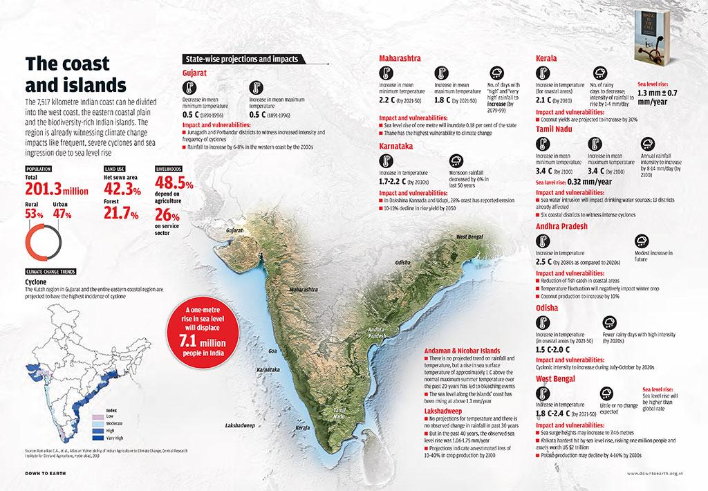
    In the absence of COVID-19, climate change-induced disasters would have been India’s biggest red alert in recent years.

    India’s vulnerabilities

    • Temperatures over the Indian Ocean have risen by over 1°C since the 1950s, increasing extreme weather events.
    • India is the fourth worst-hit in climate migration.
    • Heat waves in India have claimed an estimated 17,000 lives since the 1970s.
    • Labour losses from rising heat, by one estimate, could reach ₹1.6 lakh crore annually if global warming exceeds 2°C, with India among the hardest hit.
    • Extreme heat waves hit swathes of India. Heatwaves are aggravated by deforestation and land degradation, which also exacerbate fires.
    • Agriculture, being water-intensive, does not do well in heat wave-prone areas.

    Way forward

    • Two part approach: India needs a two-part approach:
    • Adaptation: one, to adapt to climate impacts by building resilience against weather extremes, and
    • Mitigation: to mitigate environmental destruction to prevent climate change from becoming more lethal.
    • Climate resistant agriculture: Agricultural practices which are not water-intensive and to support afforestation that has a salutary effect on warming.
    • Financial transfers can be targeted to help farmers plant trees and buy equipment — for example, for drip irrigation that reduces heavy water usage.
    • Crop diversification: Climate-resilient agriculture calls for diversification — for example, the cultivation of multiple crops on the same farm.
    • Climate-resilient agriculture calls for diversification — for example, the cultivation of multiple crops on the same farm
    • Managing vulnerable regions in coastal zones: Floods and storms are worsened by vast sea ingress and coastline erosion in the low-lying areas in the south.
    • It is vital to map flood-risk zones to manage vulnerable regions.
    • Environment Impact Assessments must be mandatory for commercial projects.
    • Design changes: Communities can build round-shaped houses, considering optimum aerodynamic orientation to reduce the strength of the winds.
    • Roofs with multiple slopes can stand well in strong winds, and central shafts reduce wind pressure on the roof by sucking in air from outside.
    • Moving away from fossil fuels: Adaptation alone will not slow climate damages if the warming of the sea level temperatures is not confronted.
    • Leading emitters, including India, must move away from fossil fuels.
    • Expanding and protecting forest cover: a big part of climate action lies in protecting and expanding forest coverage.
    • India gains from being part of the Glasgow declaration on forest protection that 141 countries signed in 2021.
    • Management of dams: Nearly 295 dams in India are more than 100 years old and need repairs.
    • In stemming landslides in Uttarakhand, regulations must stop the building of dams on steep slopes and eco-fragile areas, as well as the dynamiting of hills, sand mining, and quarrying.
    • Climate financing: India’s share in disaster management should be raised to 2.5% of GDP.
    • Climate finance is most suited for large-scale global funding from the World Bank, the International Monetary Fund, and the Asian Development Bank.
    • But smaller-scale financing can also be vital.

    Conclusion

    For public pressure to drive climate action, we need to consider climate catastrophes as largely man-made.


  • Forest restoration in India

    Context

    This month is time for Van Mahotsav, which literally means “celebrate the forest”.

    Why tree planting matters

    • According to the International Union for Conservation of Nature (IUCN), deforestation and forest degradation contribute around 12% of global greenhouse gas emissions.
    • The total area occupied by primary forests in India has decreased by 3.6%.
    • Tree planting comes with varied environmental and ecological benefits.
    • Forests are integral in regulating ecosystems, influencing the carbon cycle and mitigating the effects of climate change.
    • Annually, forests absorb roughly 2.6 billion tonnes of carbon dioxide.
    • This absorption includes nearly 33% of the carbon dioxide released from burning fossil fuels.
    • Livelihood: Forests are a boon for local communities and their livelihoods by functioning as a resource base for goods and services.
    • Enrich soil fertility: According to academics from the World Resources Institute, forest ecosystems enrich soil fertility and water availability, enhancing agricultural productivity, and in turn the rural economy.
    • Prevents erosion and flooding: Tree planting prevents erosion and stems flooding.
    • Sustainable forest crops reduce food insecurity and empower women, allowing them to gain access to more nutritional diets and new income streams.
    • Agroforestry lessens rural-to-urban migration and contributes to an increase in resources and household income.
    • Planting trees is deeply linked to the ‘wholistic’ well-being of all individuals, the community, and the planet.

    Afforestation through forest landscape restoration

    • Typically, governments have relied on afforestation and reforestation as a means of establishing trees on non-treed land. These strategies have now evolved.
    • Focus on forest landscape restoration: The focus is now on forest landscape restoration — the process of regaining ecological functionality and improving human welfare across deforested or degraded forest landscapes.
    • Community participation: Forest landscape restoration seeks to involve communities in the process of designing and executing mutually advantageous interventions for the upgradation of landscapes.
    • Nearly two billion hectares of degraded land in the world (and 140 million hectares in India) have scope for potential restoration as forest land.
    • Ensuring diversity of species: A crucial aspect of this process is to ensure the diversity of the species while planting trees.
    •  Natural forests with diverse native tree species are more efficient in sequestering carbon than monoculture tree plantations.
    • Planting diverse species is also healthier for local communities and their livelihoods.
    • An international study published earlier this year in the journal, Science, found that diversifying species in forest plantations has a positive impact on the quality of the forests.

    Programs and initiative for forest restoration

    • The span 2021-2030 is the UN Decade on Ecosystem Restoration, emphasising efforts to restore degraded terrestrial ecosystems including forests.
    • Bonn Challenge: In 2011, the Bonn Challenge was launched with a global goal to restore 150 million hectares of degraded and deforested landscapes by 2020 and 350 million hectares by 2030.
    • India joined the Bonn Challenge in 2015, pledging to restore 26 million hectares of degraded and deforested land by 2030.
    • An additional carbon sink of 2.5 billion-3 billion tonnes of carbon dioxide equivalent through forest and tree cover is to be created by 2030.
    • There are a myriad government programmes such as Compensatory Afforestation, the National Afforestation Programme, the National Mission for a Green India (Green India Mission), the Nagar Van scheme and the Forest Fire Prevention and Management Scheme to name a few.
    • The Green Skill Development Programme is for the youth who aspire to attain employment in the environment and forest sectors.

    Challenges

    • Forest restoration in India faces hurdles in terms of the identification of areas for restoration, a lack of importance accorded to research and scientific strategies in tree planting, stakeholders’ conflicts of interest, and financing.

    Way forward

    • To be successful, forest landscape restoration must be implemented proactively, bolstering landscapes and forest ecosystems to be durable and adjustable in the face of future challenges and societal needs.
    • Involvement of stakeholders: It also needs the involvement and the alignment of a host of stakeholders including the community, champions, government and landowners.
    • Participatory governance: The restoration of natural forest ecosystems can be strengthened through participatory governance by engaging stakeholders.
    • Taking into account socio-economic context: Vulnerable forest-dependent communities should be factored in, and any effort should be tailored to the local socio-economic context and landscape history of a region.

    Conclusion

    In today’s world, forests need to be celebrated more than ever before. Simultaneously, more forests need to be created and restored.

    UPSC 2022 countdown has begun! Get your personal guidance plan now! (Click here)

  • Political tussle over Podu Cultivation and Forest Lands in Telangana

    Activists have taken up the issue of Podu cultivation of adivasis and tribals in forest areas in Telangana.

    What one means by Podu?

    • Podu is a traditional system of cultivation used by tribes in India, whereby different areas of jungle forest are cleared by burning each year to provide land for crops.
    • It is a form of shifting agriculture using slash-and-burn methods. The word comes from the Telugu language.
    • Traditionally used on the hill-slopes of Andhra Pradesh, it is similar to the jhum method found in north-east India and the bewar system of Madhya Pradesh.

    What is the ‘Podu’ Land Issue?

    • The Telangana government had decided in 2021 to move landless, non-tribal farmers engaged in shifting cultivation inside forests to peripheral areas in an effort to combat deforestation.
    • It ensured that all steps would be taken to ensure that forest land was not encroached upon.
    • It is observed that podu progressively degrades large areas of the forest.

    Shifting cultivation in India

    • In this type of agriculture, first of all a piece of forest land is cleared by felling trees and burning of trunks and branches.
    • After the land is cleared, crops are grown for two to three years and then the land is abandoned as the fertility of the soil decreases.
    • The farmers then move to new areas and the process is repeated.
    • Dry paddy, maize, millets and vegetables are the crops commonly grown in this type of farming.

    This practice is known by different names in different regions of India:

    1. Jhum in Assam,

    2. Ponam in Kerala,

    3. Podu in Andhra Pradesh and Odisha and

    4. Bewar masha penda and Bera in various parts of Madhya Pradesh.


    What TS has to offer as alternative to Podu?

    • To stop this deforestation, the government wants to move out cultivators from deep inside forests to the periphery by allotting them land for cultivation.
    • Tribal farmers who have been traditionally cultivating for decades would not be affected by this drive against illegal encroachers.
    • The land ownership titles have been given to tribals and more than 3 lakh acres have been allocated to tribal farmers state-wide.

    And what about non-tribal farmers?

    • These farmers can apply to the state government to allocate them land outside the forests.
    • Those who are moved out of the forests would be given land ownership certificates, power and water supplies and Rythu Bandhu benefits.

    Back2Basics: Rythu Bandhu

    • Rythu Bandhu is a scheme under which the state government extends financial support to land-owning farmers at the beginning of the crop season through direct benefit transfer.
    • The scheme aims to take care of the initial investment needs and do not fall into a debt trap.
    • This in turn instills confidence in farmers, enhances productivity and income, and breaks the cycle of rural indebtedness.

    DBT under the Scheme

    • Each farmer gets Rs 5,000 per acre per crop season without any ceiling on the number of acres held.
    • So, a farmer who owns two acres of land would receive Rs 20,000 a year, whereas a farmer who owns 10 acres would receive Rs 1 lakh a year from the government.
    • The grant helps them cover the expenses on input requirements such as seeds, fertilizers, pesticides, and labor.


    UPSC 2023 countdown has begun! Get your personal guidance plan now! (Click here)

  • Proposed Amendments to the Environment (Protection) Act, 1986

    The Ministry of Environment, Forest and Climate Change (MoEFCC), put out a note, proposing amendments in the Environment (Protection) Act, 1986.

    Environment Protection Act (EPA), 1986

    • EP Act was passed under Article 253 of the Constitution, which empowers the Centre to enact laws to give effect to international agreements signed by the country.
    • The purpose of the Act is to implement the decisions of the UN Conference on the Human Environment.
    • They relate to the protection and improvement of the human environment and the prevention of hazards to human beings, other living creatures, plants and property.
    • It was enacted in 1986 on the backdrop of Bhopal Gas Tragedy.
    • The Act was last amended in 1991.

    Why this Act?

    • The Act is an “umbrella” legislation that has provided a framework for the environmental regulation regime in India.
    • It covers all major industrial and infrastructure activities and prohibits and regulates specific activities in coastal areas and eco-sensitive areas.
    • The Act also provides for coordination of the activities of various central and state authorities established under other environment-related laws, such as the Water Act and the Air Act.

    What are the proposed amendments?

    • The Environment Ministry has proposed amendments in four key legislations:
    1. Environment (Protection) Act, 1986
    2. Water (Prevention and Control of Pollution) Act, 1974
    3. Air (Prevention and Control of Pollution) Act, 1981 and
    4. Public Liability Insurance (PLI) Act, 1991
    • These are the cornerstone environmental laws that led to the setting up of the Central Pollution Control Board (CPCB).
    • These laws empowered the CPCB to take criminal action against individuals and corporate bodies who pollute air, water and land.

    Powers given to CPCB by these Laws

    • The clutch of laws currently empowers the CPCB to either:
    1. Shut down a polluting industrial body or
    2. Imprison executives of an organization found to be environmental violators
    • The EPA currently says that violators face imprisonment up to five years or a fine up to ₹1 lakh or both.
    • There’s also a provision for the jail term to extend to seven years.

    Purpose of the Amendments

    • The Environment Ministry had received suggestions to decriminalise existing provisions of the EPA to weed out “fear of imprisonment for simple violations.”
    • These, however, don’t apply to violations that cause grave injury or loss of life.

    How will violators be punished?

    • The changes proposed include the appointment of an ‘adjudication officer’.
    • He/She will decide on the penalty in cases of environmental violations such as reports not being submitted or information not provided when demanded.
    • Funds collected as penalties would be accrued in an “Environmental Protection Fund.”
    • In case of contraventions of the Act, the penalties could extend to anywhere from 5 lakh to 5 crore, the proposal notes.

    Need for such amendments

    • Limited success of existing laws: The history of environmental action and its success in India shows that the current laws have had limited effectiveness.
    • Backlog of cases: An analysis by the Centre for Science and Environment found that Indian courts took between 9-33 years to clear a backlog of cases for environmental violations.
    • Capitalist power: Myriad challenges dogged the process of bringing violators to book.
    • Red tapism: Flag pollution from an industrial unit would mean filing a complaint with the court of the concerned DM, or furnishing evidence to the CPCB which would again have to approach the same institution.
    • Burden of proof: In most cases, it was practically impossible to hold a specific individual in an organization responsible for a specific crime given the burden of proof required.


    UPSC 2023 countdown has begun! Get your personal guidance plan now! (Click here)

  • Places in news: Singalila National Park

    The Singalila National Park, the highest protected area in West Bengal, will soon wild Red Panda.

    Singalila National Park

    • Singalila National Park is located on the Singalila Ridge at an altitude of more than 7000 feet above sea level, in the Darjeeling district of West Bengal.
    • It is well known for the trekking route to Sandakphu that runs through it.
    • The Singalila area in Darjeeling was purchased by the British Government from Sikkim Durbar in 1882, and notified a Reserve Forest under the Indian Forest Act 1878.
    • It was notified as a National Park in 1992 and was also officially opened up for tourism.

    Why introduce Red Panda?

    • The number of red pandas has been declining in the wild, even in the Singalila and Neora Valley National Parks, the two protected areas where the mammal is found in the wild in West Bengal.
    • Recent studies estimate that there are 38 of them in Singalila and 32 in Neora.
    • The zoological park who is at the centre of the Red Panda Augmentation Programme.
    • Conservation breeding of red pandas is only one part of the programme.

    About Red Panda

    IUCN Red List: Endangered

    • The red panda (Ailurus fulgens), also known as the lesser panda, is a small mammal native to the eastern Himalayas and southwestern China.
    • It was first formally described in 1825.
    • The red panda inhabits coniferous forests as well as temperate broadleaf and mixed forests, favouring steep slopes with dense bamboo cover close to water sources.
    • It is solitary and largely arboreal.
    • It feeds mainly on bamboo shoots and leaves, but also on fruits and blossoms.


    UPSC 2023 countdown has begun! Get your personal guidance plan now! (Click here)

  • Forest Rights Act 2006

    The Odisha government is chasing an ambitious target of completing the implementation of the Forest Rights Act (FRA) by granting all kinds of rights mandated under the historic Act by 2024.

    What is Forest Rights Act (FRA)?

    • The symbiotic relationship between forests and forest-dwelling communities found recognition in the National Forest Policy, 1988.
    • The policy called for the need to associate tribal people in the protection, regeneration and development of forests.
    • The Scheduled Tribes and Other Traditional Forest Dwellers (Recognition of Forest Rights) Act, 2006, was enacted in this regard.
    • It aimed to protect the marginalised socio-economic class of citizens and balance the right to environment with their right to life and livelihood.

    Provisions of the 2006 Act

    • The Act recognizes that tribal and other traditional forest-dwelling communities would be hard put to provide documentary evidence for their claims.
    • Rule 13 of the Act, therefore, stipulates that the Gram Sabhas should consider more than one evidence in determining forest rights.
    • The rule sanctions a wide range of evidence, including “statements by village elders”, “community rights” and “physical attributes such as houses, huts and permanent improvements made to land such as levelling, bunds and check dams”.

    Why in news now?

    • The forest rights claims of these tribes and forest-dwellers are mostly rejected by the States.
    • Being poor and illiterate, living in remote areas, they do not know the appropriate procedure for filing claims.
    • The gram sabhas, which initiate the verification of their claims, are low on awareness of how to deal with them.

    Why are forest rights important for tribals?

    • Aimed at undoing the “historic injustice” meted out to forest-dependent communities due to curtailment of their customary rights over forests, the FRA came into force in 2008.
    • It is important as it recognises the community’s right to use, manage and conserve forest resources, and to legally hold forest land that these communities have used for cultivation and residence.
    • It also underlines the integral role that forest dwellers play in the sustainability of forests and in the conservation of biodiversity.
    • It is of greater significance inside protected forests like national parks, sanctuaries and tiger reserves as traditional dwellers then become a part of management of the protected forests.


    Try answering this PYQ

    Q.Under the Scheduled Tribes and Other Traditional Forest Dwellers (Recognition of Forest Rights) Act, 2006, who shall be the authority to initiate the process for determining the nature and extent of individual or community forest rights or both?

    (a) State Forest Department

    (b) District Collector/Deputy Commissioner

    (c) Tahsildar/Block Development Officer/Mandal Revenue Officer

    (d) Gram Sabha


    [wpdiscuz-feedback id=”2muu2leum7″ question=”Please leave a feedback on this” opened=”1″]Post your answers here.[/wpdiscuz-feedback]

    UPSC 2023 countdown has begun! Get your personal guidance plan now! (Click here)

  • Making sense of Assam floods

    Context

    This year’s floods in Assam have been merciless. In many parts of the state, both rural and urban, shoals of water drove people from their homes and forced many of them to seek shelter for their livestock.

    Understanding the reasons for massive flood in Assam this year

    • The Bay has a major influence on the monsoon in Northeast India.
    • Two coupled ocean-atmosphere phenomena, one from the distant Pacific, La Niña and another in the tropical Indian Ocean, a negative dipole condition, combined to create high rainfall in the Bay of Bengal.
    • To add to that, a warmer atmosphere because of climate change can hold more moisture leading to intense bouts of rain.
    • Apart from embankment failures, a number of unofficial and media reports suggest that the devastation in the floodplains is also a consequence of the way the dams and reservoirs are operated.
    • This indicates that environmental factors unique to each locality are responsible for the floods.
    • The flooding pattern is usually repeated year-to-year. However, at times, this pattern is disturbed — this year for example.
    • The incidence of such megafloods depends on several variables like unusually high rainfall and the failure of critical embankments.

    Role of floods in the making of the floodplain environment and ecology

    • Rejuvenation of ecosystem: Floods cause disruption and damage but they also generate a bounty of fish and rejuvenate flood-plain ecosystems all along the Brahmaputra, including in the Kaziranga.
    • Landscape: This landscape has been shaped over millions of years with the help of an active monsoonal environment and mighty rivers that carry sediments weathered from the still-rising Himalaya.
    • Every year, the Brahmaputra and its tributaries — which are at the centre of Assam’s environment — transport billions of tonnes of sediment, mainly from the Eastern Himalaya, making the landscape volatile.
    • Flooding helps release waters to surrounding land and distribute sediments and nutrients across the floodplains and wetlands.

    How human presence has influenced floodplains

    • As the human footprint intensified on the floodplains, the landscape was increasingly “developed and engineered”.
    • The engineered and planned landscape has affected the floodplains in two ways: It has undermined their ability to store and absorb water and reduced their capacity to transport sediment.
    • Urban floods: This year’s floods took an especially worrying proportion in several urban areas.
    • Guwahati has historically been a lowland and the city has been uniquely shaped by three hills that accumulate water during the monsoon.
    • Its northern side faces one of the most turbulent rivers in the world.
    • However, extensive swamps, channels and their tributaries worked in tandem to make the place habitable.
    • A transformation, however, took place in the 20th century, especially in the later decades, when these natural features were forced to disappear.
    • From an estimated 11,000 people in 1901, the city now is home to close to 1.1 million people.
    • Such a population increase is bound to have several footfalls and not all of them could have been prevented.
    • What has hit the city hardest is the disappearance of some of its critical environmental features.

    Way forward

    • Human interventions such as dams to “tame” rivers and “stabilise” hydrologically dynamic landscapes and riverscapes should be based on guidelines that account for the environmental conditions in Northeast India, especially the fragile geology, changing rainfall patterns, high seismicity and the risk of landslides.
    • Resilience of people: The rapid transformation in rainfall characteristics and flooding patterns demand building people’s resilience.
    • Reconsider projects: Construction projects that impede the movement of water and sediment across the floodplain must be reconsidered.
    • Use of technology: At the same time, climate-imposed exigencies demand new paradigms of early-warning and response systems and securing livelihoods and economies.

    Conclusion

    Floods have played a key role in Assam’s ecology. But increasing human footprint has affected the ability of flood plains to absorb water and transport sediment.

    UPSC 2023 countdown has begun! Get your personal guidance plan now! (Click here)