💥Join UPSC 2027,2028 Mentorship (July Batch) + XFactor Notes & Microthemes PDF

Subject: Disaster Management

  • Why Zoning of Flood Plains is important?

    flood plain

    Central Idea

    • Punjab has been grappling with severe floods for over a month, predominantly affecting villages along rivers like Sutlej, Beas, Ravi, and Ghaggar.
    • These areas, known for their fertile flood plains, have been hit the hardest due to floods exacerbated by encroachments and construction.

    Flood Plains and their Significance

    • Flood plains adjacent to rivers serve as natural defences against inland flooding. Maintained without concrete encroachments, they absorb excess water, safeguarding other regions.
    • Properly managed flood plains also aid in recharging groundwater levels and maintaining the water table.

    What is Zoning of Flood Plains?

    • Zoning of flood plains refers to the practice of categorizing and regulating different areas within flood-prone regions based on their vulnerability to flooding and the intensity of flood events.
    • This aims to manage land use and construction activities in these areas to minimize the risks associated with flooding, protect communities and infrastructure, and maintain the natural functions of flood plains.
    • It involves designating specific zones within flood-prone regions and establishing regulations and guidelines for development, construction, and land use in each zone.

    Current Scenario: No Zoning in Punjab

    • National Green Tribunal (NGT): NGT guidelines state that construction should not occur within 500 meters of a river’s central lining.
    • Punjab’s Lag: Despite NGT’s directives and the need for floodplain zoning, Punjab has yet to initiate the process. Encroachments persist, putting riverside villages at perpetual risk.

    Impact of Inaction: People and Ecosystems Affected

    • Risk to People and Property: Unregulated construction leads to increased flood risks further inland, causing greater harm during floods.
    • Environmental Impact: Concretization of flood plains delays water drainage and affects soil fertility and quality.

    Flood Prone Districts and National Issue

    • Districts at Risk: Many districts including Ropar, Ludhiana, Ferozepur, Patiala, and more fall within flood plains, magnifying the need for preparedness.
    • Nationwide Challenge: While only four states have adopted flood plain zoning in principle, implementation has been insufficient. Even those that adopted zoning have not effectively delineated and demarcated flood plains.

    Activists’ Advocacy

    • Activists’ Concerns: Environmental activists and NGOs in Punjab have been advocating for flood plain zoning to mitigate risks.
    • Urgent Implementation: Immediate initiation and completion of flood plain zoning are crucial to safeguard lives, property, and ecosystems from devastating floods.

    Conclusion

    • The recent floods in Punjab underline the urgency of flood plain zoning to avert catastrophe.
    • By adopting effective zoning measures, the state can shield its citizens and environment from the damaging impacts of unchecked construction and flooding.
    • It is imperative that Punjab takes swift action to implement flood plain zoning and thereby protect its vulnerable regions from the perpetual threat of floods.
  • In news: International Atomic Energy Agency (IAEA)

    Central Idea

    • Japan has begun discharging treated radioactive wastewater from the disabled Fukushima Daiichi Nuclear Power Station into the Pacific Ocean in a plan endorsed by the International Atomic Energy Agency (IAEA).

    International Atomic Energy Agency (IAEA)

    • IAEA is an international organization that plays a pivotal role in promoting the peaceful use of nuclear energy while preventing the proliferation of nuclear weapons.
    • It was established in 1957 as an autonomous agency under the UN is headquartered in Vienna, Austria.
    • It plays a crucial role in safeguarding the principles outlined in the Nuclear Non-Proliferation Treaty (NPT) of 1970.
    • Despite its independent treaty, the IAEA remains accountable to both the UN General Assembly and the United Nations Security Council (UNSC).

    What does it do?

    • Promotion of Peaceful Nuclear Energy: Established amidst the Cold War’s geopolitical tension, the IAEA’s core mission centers on promoting the constructive application of nuclear energy.
    • Prevention of Military Use: The agency’s fundamental role is to prevent the diversion of nuclear programs for military intentions, ensuring compliance with international agreements.

    IAEA’s Tri-fold Missions

    • Peaceful Utilization: Fostering member states’ constructive adoption of nuclear energy for peaceful purposes constitutes a pivotal aspect of IAEA’s mission.
    • Safeguarding Measures: A cornerstone role of the IAEA involves implementing measures to verify the non-military use of nuclear energy, particularly through assessing declared nuclear activities and materials.
    • Nuclear Safety: The IAEA takes an active stance in advocating stringent standards of nuclear safety to prevent accidents and ensure public and environmental protection.

    Significant feature: IAEA’s Safeguards

    • Purpose of Safeguards: IAEA’s safeguards are mechanisms designed to affirm that a nation adheres to its international commitment against exploiting nuclear programs for weaponry purposes.
    • Verification Approach: Safeguards are founded on the meticulous examination of a state’s reported nuclear materials and activities, evaluating their accuracy and completeness.
    • Varied Verification Measures: The agency employs a range of verification tools, including on-site inspections, visits, and ongoing monitoring, ensuring rigorous oversight.

    Dual Dimensions of Safeguards

    • Declared Nuclear Material Verification: Through the inspection of reported nuclear materials and activities, IAEA ensures that a state remains transparent in its nuclear endeavors.
    • Non-Diversion Assurance: A significant facet is the assurance of the absence of undeclared nuclear materials or activities, thereby averting any unauthorized deviation from peaceful usage.
  • Himachal Floods: A man-made disaster?

    himachal

    Central Idea

    • Himachal Pradesh has experienced devastating flash floods during the recent monsoon season, resulting in a significant loss of lives and assets.
    • This article explores the factors contributing to the floods, including climate change and anthropogenic actions, and raises questions about the current development model’s sustainability.

    Reasons for amplified Flood Impacts

    [A] Climate Change and Floods

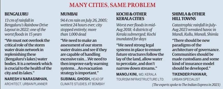
    • IPCC’s Warning: The IPCC VI report predicts that the Himalayas and coastal regions of India will be the hardest hit by climate change. Increased precipitation in shorter periods is evident in the Himalayas, leading to heavy rains and floods.
    • Abnormal Rainfall: Normal rainfall is expected to be between 720mm and 750mm, but instances of exceeding 888mm in 2010 and 926.9mm in 2018 have been observed. The current precipitation has been a result of the combined effect of the southwest monsoon and western disturbances.

    [B] Impact of Development Model

    • Dr. Parmar Model: Himachal Pradesh’s development model, initiated in 1971, transformed the state into a model of development for mountain regions. It focused on land reforms, social welfare investments, and human resource development.
    • Shift in Development: Liberalization brought demands for fiscal reforms, forcing the state to generate its own resources. Exploitation of natural resources such as forests, water, tourism, and cement production became the focus of development efforts.
    • Hydropower Projects: Dominant focus on hydropower projects led to uncontrolled construction, transforming mountain rivers into streams, and causing ecological damage.
    • Tourism Expansion: Road expansion for tourism promotion resulted in bypassing geological studies, leading to landslides and destruction during rainfall.
    • Cement Plants: Establishment of massive cement plants altered the landscape, reducing the land’s water absorption capacity and contributing to flash floods.
    • Changing Crop Patterns: Shift from traditional cereal farming to cash crops increased the demand for hastily constructed roads without proper drainage, leading to rapid swelling of rivers during rainfall.

    Way Forward

    • Commission of Inquiry: Instituting a Commission of Inquiry involving major stakeholders can address policy framework failures and project aspects.
    • Empowering Local Communities: A new architecture is needed to empower local communities over their assets. Insuring assets and involving local communities as custodians can expedite rebuilding efforts.
    • Sustainable Infrastructure: With climate change as a reality, infrastructure planning should adapt to avert disasters and mitigate the impacts of heavy rainfall.

    Conclusion

    • The flash floods in Himachal Pradesh demonstrate the consequences of both climate change and human-induced development.
    • It calls for a comprehensive approach that considers sustainable development practices, empowers local communities, and prioritizes environmental conservation to protect lives and assets in the region.
  • Lightning not a Natural Disaster: Centre

    light

    Central Idea

    • A senior government official stated that lightning deaths can be prevented through education and awareness, and thus, the government is against declaring it a natural disaster.

    Why discuss this?

    • State Demands: States like Bihar and West Bengal have requested that lightning-related deaths be considered natural disaster, making victims eligible for compensation from the State Disaster Response Fund (SDRF).
    • Increased fatalities: According to the National Crime Records Bureau, lightning caused 2,880 deaths in 2021, accounting for 40% of all accidental deaths from “forces of nature.”

    What is Lightning?

    Lightning is a rapid and powerful discharge of electricity in the atmosphere, often directed towards the Earth.

    • Genesis: Lightning discharges occur in giant, moisture-bearing clouds that are several kilometers tall.
    • Ice Crystal Formation: Water vapor in the clouds condenses into small ice crystals as temperatures drop below 0°C.
    • Electron Release and Collision: Collisions between ice crystals generate a release of electrons, leading to a chain reaction and the formation of a positive and negative charge within the cloud.
    • Types: Lightning can occur within clouds (inter-cloud and intra-cloud) or between the cloud and the ground (cloud-to-ground).

    Intensity of Lightning Strikes

    • Voltage and Amperage: A typical lightning flash can reach around 300 million volts and 30,000 amps, significantly higher than household current.
    • Comparisons: Household current is 120 volts and 15 amps, highlighting the immense power of lightning.

    Mitigating Lightning Incidents

    • Early Warning System: India has established an early warning system for lightning, saving numerous lives.
    • Focus on Rural Areas: Over 96% of lightning deaths occur in rural areas, necessitating mitigation and awareness programs targeted at these communities.
    • Deployment of Protection Devices: Low-cost lightning protection devices need to be deployed more widely, especially in rural areas.
    • Lightning Action Plans: States are encouraged to develop and implement lightning action plans, similar to heat action plans, to mitigate lightning-related risks.
    • International Centre for Excellence: Efforts are underway to establish an international center for excellence in lightning research to enhance detection and early warning systems.


  • States demand that ‘Lightning’ be declared a Natural Disaster

    Central idea: A few states have requested lightning to be declared a natural disaster due to the high number of deaths caused by it in the country.

    Why discuss this?

    • Around 2,500 people die every year due to lightning.
    • Present norms consider cyclones, droughts, earthquakes, fires, floods, tsunamis, hailstorms, landslides, avalanches, cloudbursts, pest attacks, frost, and cold waves as disasters covered under the State Disaster Response Fund.
    • Deliberations are necessary as it is a policy issue.

    What is lightning?

    • Scientifically, lightning is a rapid and massive discharge of electricity in the atmosphere some of which is directed towards earth.
    • The discharges are generated in giant moisture-bearing clouds that are 10-12 km tall.
    • The base of these clouds typically lie within 1-2 km of the Earth’s surface, while the top is 12-13 km away.
    • Temperatures in the top of these clouds are in the range of –35° to –45°C.

    Its formation

    • As water vapour moves upward in the cloud, the falling temperature causes it to condense.
    • As they move to temperatures below 0°C, the water droplets change into small ice crystals.
    • They continue to move up, gathering mass until they are so heavy that they start to fall to Earth.
    • This leads to a system in which, simultaneously, smaller ice crystals are moving up and bigger crystals are coming down.
    • Collisions follow and trigger the release of electrons, a process that is very similar to the generation of sparks of electricity.
    • As the moving free electrons cause more collisions and more electrons, a chain reaction ensues.
    • This process results in a situation in which the top layer of the cloud gets positively charged, while the middle layer is negatively charged.
    • The electrical potential difference between the two layers is huge, of the order of a billion to 10 billion volts.
    • In very little time, a massive current, of the order of 100,000 to a million amperes, starts to flow between the layers.

    Types of lightning

    • Broadly, there are three forms of lightning:
    1. Inter-cloud
    2. Intra-cloud
    3. Cloud-to-ground
    • It is the cloud-to-ground form of lightning that kills humans, as well as animals and livestock, and can substantially damage property.
    • While the Earth is a good conductor of electricity, it is electrically neutral.
    • However, in comparison to the middle layer of the cloud, it becomes positively charged.
    • As a result, about 15%-20% of the current gets directed towards the Earth as well.
    • It is this flow of current that results in damage to life and property on Earth.

    How intensely does it strike?

    • A typical lightning flash is about 300 million volts and30,000 amps.
    • To put it in perspective, household current is 120 volts and 15 amps.
    • A flash of lightning is enough to light a 100-watt incandescent bulb for about three months.

    Why does lightning kill so many people in India?

    • The reason for the high number of deaths is due to people being caught unawares and more than 70% of fatalities happened due to people standing under isolated tall trees.
    • About 25 per cent of the people were struck in the open.
    • Also, lightning is the direct promulgation of climate change extremities.

    Mitigating lightning incidents

    • Lightning is not classified as a natural disaster in India.
    • But recent efforts have resulted in the setting up of an early warning system that is already saving many lives.
    • More than 96% of lightning deaths happen in rural areas.
    • As such, most of the mitigation and public awareness programmes need to focus on these communities.
    • Lightning protection devices are fairly unsophisticated and low-cost. Yet, their deployment in the rural areas, as of now, is extremely low.
    • States are being encouraged to prepare and implement lightning action plans, on the lines of heat action plans.
    • An international centre for excellence on lightning research to boost detection and early warning systems is also in the process of being set up.
  • ISRO releases Landslide Atlas of India

    landslide

    The Indian Space Research Organisation (ISRO) recently released the Landslide Atlas of India to identify landslide hotspots in the country.

    What are Landslides?

    • Landslides are natural disasters that occur in mountainous terrains where soil, rock, geology, and slope conditions are conducive.
    • A landslide is the sudden movement of rock, boulders, earth, or debris down a slope.
    • They can be triggered by natural causes such as heavy rainfall, earthquakes, snowmelting, and undercutting of slopes due to flooding.
    • They are extremely hazardous, posing a threat to human and animal lives, damaging property, roads, and bridges, disrupting communication lines, and snapping power lines.
    • Landslides are broadly classified based on the type of materials involved, the type of movement of the material, and the type of flow of the material.

    Why do they occur?

    • Landslides are natural disasters that occur mainly in mountainous terrains due to conducive conditions of soil, rock, geology, and slope.
    • Heavy rainfall, earthquakes, snow-melting, and undercutting of slopes due to flooding can trigger landslides.
    • Anthropogenic activities such as excavation, cutting of hills and trees, excessive infrastructure development, and overgrazing by cattle can also cause landslides.

    Factors contributing

    • The main factors that influence landslides include lithology, geological structures like faults, hill slopes, drainage, geomorphology, land use and land cover, soil texture and depth, and weathering of rocks.
    • Rainfall variability pattern is the single biggest cause for landslides in India, with the Himalayas and the Western Ghats remaining highly vulnerable.

    India’s vulnerability to landslides

    • India is considered among the top five landslide-prone countries globally, where at least one death per 100 sq. km is reported in a year due to a landslide event.
    • Approximately 12.6% of the country’s geographical land area (0.42 million sq km) is prone to landslides, with 66.5% of landslides reported from the North-western Himalayas, 18.8% from the North-eastern Himalayas, and 14.7% from the Western Ghats.

    Risks in specific states          

    • Mizoram recorded the highest number of landslide events in the past 25 years, with 12,385 events, of which 8,926 were recorded in 2017 alone.
    • Nagaland and Manipur also reported a high number of landslide events during the 2017 monsoon season.
    • Uttarakhand and Kerala reported the highest number of landslides, with Uttarakhand experiencing 11,219 events since 1998, and Kerala making inhabitants significantly vulnerable to fatalities, despite fewer events.

    Classification and Mapping of Landslides

    • Landslides are broadly classified based on the type of materials involved, type of movement, type of flow of the material, and whether they spread laterally.
    • The Landslide Atlas of India maps landslides mainly based on events and seasons.
    • The National Remote Sensing Centre (NRSC) used a landslide database created from 1998 to 2022 using aerial and high-resolution satellite images.


  • Turkey hit by series of powerful Earthquakes: The science behind it

    turkey

    More than 4000 people died and several hundred were injured after a major earthquake of magnitude 7.8 hit south-central Turkey and Northwest Syria.

    What is an Earthquake?

    • An earthquake is an intense shaking of the ground caused by movement under the earth’s surface.
    • It happens when two blocks of the earth suddenly slip past one another.
    • This releases stored-up ‘elastic strain’ energy in the form of seismic waves, which spreads through the earth and cause the shaking of the ground.

    What exactly causes Earthquakes?

    • As we know, the earth’s outermost surface, crust, is fragmented into tectonic plates.
    • The edges of the plates are called plate boundaries, which are made up of faults.
    • The tectonic plates constantly move at a slow pace, sliding past one another and bumping into each other.
    • As the edges of the plates are quite rough, they get stuck with one another while the rest of the plate keeps moving.
    • Earthquake occurs when the plate has moved far enough and the edges unstick on one of the faults.
    • The location below the earth’s surface where the earthquake starts is called the hypocenter, and the location directly above it on the surface of the earth is called the epicentre.

    How prone is Turkey to Earthquakes?

    • Turkey and Syria lie in a seismically active region
    • The region where the earthquake has struck lies along a well-known seismic fault line called the Anatolia tectonic block that runs through northern, central, and eastern Turkey.
    • It is a seismically active zone — though not as active as, say, the Himalayan region which is one of the most dangerous regions in the world from the perspective of earthquakes.

    What makes Turkey a hotbed of seismic activity?

    turkey

    • Turkey is frequently shaken by earthquakes. In 2020 itself, it recorded almost 33,000 earthquakes in the region.
    • Turkey is located on the Anatolian tectonic plate, which is wedged between the Eurasian and African plates.
    • On the north side, the minor Arabian plate further restricts movement.
    • One fault line — the North Anatolian fault (NAF) line, the meeting point of the Eurasian and Anatolian tectonic plates — is known to be “particularly devastating”.
    • Then there is the East Anatolian fault line, the tectonic boundary between the Anatolian Plate and the northward-moving Arabian Plate.
    • It runs 650 kilometers from eastern Turkey and into the Mediterranean.
    • In addition to this, the Aegean Sea Plate, located in the eastern Mediterranean Sea under southern Greece and western Turkey, is also a source of seismic activity in the region.

    Where was the earthquake epicentered?

    • The centre of the earthquake was centred about 33 km from Gaziantep, around 18 km deep.
    • Its effect was felt across West Asia, Northern Africa and South Eastern Europe with residents of Lebanon, Cyprus, Greece, Israel and Egypt also reporting tremors.

    Aftermath: Many Aftershocks hits the region

    • Aftershocks are a sequence of earthquakes that happen after a larger mainshock on a fault.
    • Aftershocks occur near the fault zone where the mainshock rupture occurred and are part of the “readjustment process” after the main slip on the fault.
    • While they become less frequent with time, although they can continue for days, weeks, months, or even years for a very large mainshock.

    Can earthquakes be predicted?

    • An accurate prediction of an earthquake requires some sort of a precursory signal from within the earth that indicates a big quake is on the way.
    • Moreover, the signal must occur only before large earthquakes so that it doesn’t indicate every small movement within the earth’s surface.
    • Currently, there is no equipment to find such precursors, even if they exist.

    India offers assistance

    • India is among the 45 countries, which have so far offered assistance to Turkey.
    • It’s sending search and rescue teams of the National Disaster Relief Force (NDRF) and medical teams along with relief material to the West Asian nation.
  • EIA must before allowing urban development projects: SC

    The Supreme Court has urged legislators and policy experts to ensure that Environment Impact Assessment (EIA) studies are done before giving the green signal for urban development projects in India’s cities.

    What is the news?

    • The Supreme Court how haphazard urban development has ruined the ‘Garden City’ of Bengaluru as witnessed during a major spell of rain in September 2022.
    • The court said that the city struggled for drinking water while it lay submerged after the downpour.

    Food and Agricultural Organization (FAO) defines it as,

    a formal process to predict the environmental consequences of human development activities and to plan appropriate measures to eliminate or reduce adverse effects and to augment positive effects.

    • Thus, Environmental Impact Assessment (EIA) is an integral part of Environmental Management. It investigates likely impacts, both positive and negative, of development projects on the surrounding environment.
    • Simply put, EIA is a detailed study regarding the impacts of any project on the environment. It serves as a decision-making tool which helps policy makers approve, reject or find an alternative to a project

    EIA

    In India, Environment Impact Assessment (EIA) is notified under the Environment (Protection) Act 1986.

    Evolution of EIA 

    • The origin of EIA lies in the enactment of the National Environmental Policy Act(NEPA) in the year 1969 in the USA. It not only introduced the concept of environmental impact assessment but also made it necessary for federal agencies to evaluate impact of environmental decisions.
    • Environment Impact Assessment gained popularity after the introduction of the concept of sustainable developmentvia World Commission on Environment 1987 & United Nations Conference on Environment and Development (Rio Summit) in 1992. It led to adoption of EIA in many countries as well. Principle 17 of the Rio Summit states that,
    • Environmental impact assessment (EIA), as a national instrument, shall be undertaken for proposed activities that are likely to have a significant adverse impact on the environment and are subject to a decision of a competent national authority[Given just for your info. No need to remember this type of complex language.Instead, you can mention that EIA is mentioned explicitly under Principle 17 of the Rio declaration of 1992].
    • In 1976-77, EIA was started in India, when the Department of Science and Technology was asked by Planning Commission to examine the river-valley projects from the environmental angle.
    • Eventually n 1994, EIA was made mandatory in India under the Environmental (Protection) Act, 1986. Until then, environmental clearance from the Central Government was an administrative decision and had no legislative backing.
    • Since then, EIA has been amended several times. The most significant amendment was made in 2006

    EIA Process

    Environment Impact Assessment (EIA) process can vary depending on a country’s policy and requirement. However, EIA process in most countries, including India, have the following steps:

    1. Screening
    2. Scoping
    3. Collection of baseline data
    4. Impact Prediction
    5. Assessment of alternatives, mitigation measures & Environmental, Impact Assessment Report
    6. Public Hearing
    7. Decision Making
    8. Monitoring the clearance conditions

    Screening: This is the first step in the EIA process. At this stage it is decided whether the proposed project needs an EIA and if so to what detail. Screening criteria are based upon:

    • Scales of investment
    • Type of development
    • Location of development

    Scoping: It is the most significant step in the entire EIA process as key environmental issues involved are identified at this stage.

    • Scoping has to be done by consultants in consultation with the project proponent and guidance, if needed, from Impact Assessment Agency
    • The Ministry of Environment and Forests has published sector-wise guidelines which outline the significant issues which have to be addressed while conducting the EIA studies.
    • At the end of scoping, detailed terms of reference (TOR) are prepared of EIA.
    • TOR is a written document containing written requirements governing EIA implementation, consultations to be held, data to be gathered, methodology to be used etc

    Involved in Environmental Impact Assessment

    Collection of baseline data: It describes the existing environmental status of the identified study area. The site-specific primary data is monitored and supplemented with secondary data

    Impact prediction: Under this, possible effects on the physical, biological, social and economic conditions are taken into consideration and measures are suggested to prevent, reduce or compensate for the impacts.

    For example:

    • Impact of biological diversity in an area ex. EIA done by Gadgil panel on the western ghats regions.
    • Impact on habitat because of deforestation and pollution- Impact on Himalayan ecosystem when hydropower projects are opened.
    • Impact on endangered animals and migratory paths. For ex Great India hornbill’s trail in India is evaluated so as to see that such developmental project is not affecting its pathway.
    • The predictions of impact can never be absolute and certain and thus there is a need to comprehensively consider all factors and take all possible precautions for reducing the degree of uncertainty.

    Assessment of alternatives, mitigation measures & Environmental Impact Assessment Report: Identification of alternatives and their comparison: For every project, possible alternatives are to be identified and environmental impacts and benefits to be compared.

    • Alternatives should then be ranked for selection of the best environmental option for optimum economic benefits to the community at large.
    • Environment Management Plan (EMP): Once alternatives have been reviewed, an impact mitigation plan is drawn up for the selected option and is supplemented with an Environmental Management Plan (EMP) to guide the proponent towards environmental improvements. EMP is a crucial input to monitoring the clearance conditions and therefore details of monitoring should be included in it.
    • EMP is a site-specific plan developed to ensure that the project is implemented in an environmentally sustainable manner where all contractors and subcontractors, including consultants understand the potential environmental risks arising from the project and take appropriate actions to properly manage that risk.
    • An Environmental Impact Assessment (EIA) Report prepared at this stage should provide clear information to the decision maker on the different environmental scenarios without the project, with the project and with project alternatives.

    Public Hearing: Public must be informed and consulted on a proposed development after the completion of EIA report

    • Gram Sabha must be consulted before the project starts. Gram Sabha means the electorate (people eligible to vote) of the region

    Decision-making: It involves consultations between the project proponent (assisted by a consultant) and the impact assessment authority (assisted by an expert group if necessary). Final decision regarding the project is taken, keeping in mind EIA and EMP (Environment Management Plan).

    Monitoring: Monitoring should be done during both construction and operation phases of a project. This is not only to ensure that the commitments made are complied with but also to observe whether the predictions made in the EIA reports were correct or not.

    • Where the impacts exceed the predicted levels, corrective action should be taken.
    • Monitoring enables the regulatory agency to review the validity of predictions and the conditions of implementation of the Environmental Management Plan (EMP).

    Objective of EIA

    • To bring out a national policy to encourage productive and enjoyable harmony between man and environment.
    • To promote efforts to prevent or eliminate damage to the environment.
    • To increase understanding of ecological systems and natural resources important to the nation

    Why we need Environmental Impact Assessment (EIA)? / Significance of EIA / Benefits of EIA

    • Facilitates sustainable development: In present times anthropogenic activities like rapid industrialization, mass production and clearing of forests have created immense pressure on the natural environment. Tools like EIA help in balancing the need for economic growth with equally important concept of sustainability.
    • Mitigating negative impacts & informed decision-making– Environmental Impact Assessment (EIA) helps in minimizing the negative impact of various development projects. It enables monitoring programmes to be established to assess future impacts and provide data on which managers can take informed decisions to avoid environmental damage.
    • Aids cost-effectiveness– EIA helps in selection and design of projects, programmes or plans with long term viability and therefore improves cost effectiveness.
    • Advance assessments also helps avoid future losses that may be incurred if the project is found environmentally unacceptable at a later stage. Cost of adaptation when a project is already running is usually more.

    Thus, EIA as a tool aims to minimize the environmental impacts emanating out of any economic activity that have the potential to cause environmental degradation.

    Environmental Components

    Rapid EIA vs Comprehensive EIA

    The difference is in the time scale of the data supplied. But both types require complete coverage of all EIA procedures

    • Rapid EIA: Under Rapid EIA data supplied is of only one season(other than monsoon) to reduce the time required. Rapid EIA is for speedier appraisal process.
    • Comprehensive EIA: It collects data from all four seasons.Rapid EIA is acceptable if it does not compromise upon the quality of decision making. The review of Rapid EIA submissions will show whether a comprehensive EIA is warranted or not. Therefore, submission of comprehensive EIA in the first stance would generally be more efficient approach. Comprehensive EIA includes appraisal of those projects whose analysis in not to be done soon, here time is not the essential factor but the quality of the appraisal is.

    EIA notifications

    Central govt has the power to issue EIA notifications under Section 3 of the Environment Protection Act, 1986, wherein it can impose restrictions on setting up new projects or expansion or modernisation of existing projects. The section stipulates that such measures must benefit the environment.

    Under the Environment (Protection) Act of 1986, first EIA notification was issued in 1994. Later, it was replaced by a modified draft in 2006

    Salient Features of EIA rules Amendment done in 2006 

    • Environmental Impact Assessment Notification 2006 decentralized the environmental clearance projects by categorizing the developmental projects in two categories i.e., Category Aand Category B

    Salient features of EIA

    After 2006 Amendment, EIA comprises of four cycles:

    • Screening
    • Scoping
    • Public Hearing
    • Appraisal
    • State Level Environment Impact Assessment Authority (SEIAA) and State Level Expert Appraisal Committee (SEAC) are constituted to provide clearance to category B projects.
    • Category A Projects require mandatory environmental clearance. Screening process is not required.
    • Category B projects undergo screening process. They are classified in two types:
    • Category B1 Projects: Mandatorily require EIA
    • Category B2 Projects: Do not require EIA

    Thus,

    • Category Aprojects and category B1 projects undergo the complete EIA process
    • Category B2projects are excluded from complete EIA process

    This 2006 EIA notification has undergone several amendments over last 14 years. A new draft EIA Notification 2020 has been floated by the govt. It is meant to incorporate the amendments and court orders issued since 2006.

    Major Provisions of draft EIA notification 2020

    • Public Consultation 
    • Period of public consultation hearings is proposed to be reduced to a maximum of 40 days.
    • Time provided for the public to submit their responses is proposed to be reduced from present 30 to 20 days.
    • Rationale by the govt: the shorter window was “in tune with the times”, given the growth of internet and mobile telephony.
    • Concern: Several environmental activists and organisations have instead argued that even the 30-day timeframe was inadequate as information failed to reach the stakeholders residing in remote and inaccessible terrains
    • More discretionary powers to government
    • Central government can declare “economically sensitive areas” without public hearing or environmental clearance
    • Government also gets to decide which projects are to be considered “strategic”.
    • Post-facto clearance: Legalisation of projects that have commenced operations without obtaining necessary clearances; subject to a payment of penalty.

    Supreme court’s view on postfacto clearance –

    • In a judgment in early 2020, in the case of Alembic Pharmaceuticals Ltd vs Rohit Prajapati,the Supreme Court by also referring to Common Cause vs. Union of India judgment, struck down and condemned ex-post facto environmental clearance (a concept which the new draft EIA proposes to regularise).
    • In 2013, the Hon’ble Supreme Court in the case of Association for Environmental Protection vs State of Kerala, held that commencement of projects without obtaining prior EC (environmental clearance) is a violation of the fundamental right to lifeguaranteed under Article 21 of the Constitution


    • Post-clearance compliance: Post-clearance compliance implies that once a project gets approved by the concerned authority, the proponent projects are required to adhere to certain rules laid down in the EIA report in order to ensure that no further environmental damages take place.
    • The new draft EIA, contrary to the 2006 notification — which required submission of the compliance report every six months, proposes annual reports. 
    • Concern: Environmental experts are of the view that allowing a longer period for filling the compliance report will give an opportunity to project proponents to hide disastrous consequences, which could go unnoticed


    • Exemption clause: It identifies a long list of projects like roads and pipelines in border areas which have been exempted from public consultation and prior clearance.
    • Concern: Analysts note that by this provision, the government shall have discretion to designate any project as being of strategic importance. Activists in states with crucial resources like uranium, as in Meghalaya, have also opposed this provision


    • Baseline Data: Does away with the need to carry out studies covering all seasons in a year

    In the 2019 ‘Ease of Doing Business’ report by the World Bank, India rose steadily from 142nd ranking in 2014 to 63rd ranking in 2019. India, however, has steadily declined on Environment Performance Index, from 141st rank in 2016 to 168th rank out of 180 countries in 2020.

    The government has assured that it will strive to strike a balance between the environmental and developmental concerns. As and when the EIA is finalised, it is expected to incorporate the perspectives of multiple stakeholders in a balanced manner.

    Shortcomings of the Environment Impact Assessment (EIA) process

    Applicability: There are several projects with environmental impacts that are exempted from the notifications. Ex. Low scale sand mining

    Inadequate capacity of EIA approval authorities: Lack of technical and environmental experts, anthropologists and social scientists among the members and involvement of crony capitalism and nexus between corporates and politicians leads to faulty decision making, where projects which severe harm the environment may also get approved.

    Deficiencies in screening, scoping and impact analysis: There are no independent bodies and no standardized formats for project evaluation.

    • Absence of standardized baseline data brings arbitrariness in impact prediction.
    • It is allegedly done by those people which are on the payroll of company which creates a conflict of interest. They intentionally exclude negative impact on forests/ environment and impact on tribes during the scoping process

    Poor quality EIA reports: EIA is presently used as a project justification tool rather than as a project planning tool to contribute to achieving sustainable development. Involvement of planning for future activities should also be focused upon along with the justification of the project itself.

    • EIA is not just a tool to describe YES or NO regarding a project but also about how the harm, if any, to the environment can be minimized, so as to be pollution-neutral and environmentally sustainable.

    Initiated at a later stage: Another flaw in the EIA process in India is that it is undertaken at a much later stage, especially after the project has been designed, approved and almost ready for construction. Thus, by the time EIA starts huge costs are incurred and the project becomes too big to fall.

    Inadequate public participation: In many countries like Nepal, Argentina and Australia, public involvement is mandatory at various stages of the EIA process (i.e., screening, scoping, report preparation and decision making), but in India public consultation occurs only once during the entire process. According to the EIA notification 2006, this public consultation is performed in two ways.

    • First, written comments are sought on draft EIA report from stakeholders
    • Second, public hearing is conducted at or near the proposed project site.

    Drawbacks of this system:

    • Public consultation is done after the preparation of draft EIA reportand when it is ready for final submission to the expert committee.
    • Also, the notification issued for public hearing are not published in local vernacular languagesthus keeping it out of the scope of understanding of locals.

    Weak monitoring: Monitoring is not done through an independent agency. Environment management plans of strategic industries like nuclear energy are not put into the public domain.

    How can we strengthen the EIA process?

    1.Independent Agency: Entire EIA process right from screening to monitoring should be done by independent agencies and establishing a National Accreditation Body for agencies carrying out EIA.

    • Creation of centralized baseline data bank

    2.Applying Precautionary Principle: This principle states that if there is a threat of serious damage (in this case, to the environment) from a particular action then a lack of scientific certainty should not be used to avoid taking steps to prevent that damage. Hence, the list of concerns raised by the public should be studied in detail to arrive at any conclusion. Ex. GM crops.

    • Clearances given to project that is not clearly justified becomes questionable as happened in Sethusamudram Project

    3.Strategic Environment Assessment (SEA): It helps in choosing a project and not just evaluate it. It offers alternatives and guides project financing. The directives of SEA are reflected in the National Environment Policy 2006. Similarly, Nepal also carries out SEA’s.

    • A Strategic Environmental Assessment (SEA) is a systematic process for evaluating the environmental implications of a proposed policyplanor programme

    4.Robust and Inclusive public hearing: A key role for local people through Panchayats and Urban Local Bodies (ULBs) at every stage. Special focus on forests and tribal. The traditional knowledge of locals needs to be incorporated.

    5.Transparency: Greater transparency in the clearance process and dissemination of all documents for public scrutiny.

    6.Capacity Building: NGO’s, civil society groups and local communities need to build their capacities to use the EIA notification towards better decision-making on projects that can impact their local environments and livelihoods. Capacities can be built to proactively and effectively use the notification rather than respond in a manner that is seen as negative or unproductive.

    Way forward

    In a world that is challenged by environmental degradation and social conflicts, scholars have upheld public and local participation to be a “threshold condition” for development. EIA provides this necessary element in the economic development process. Therefore, EIA-based approvals for most projects should mandatorily and necessarily involve the process of conducting public hearings so that the views and opinions of people who are likely to be affected can be taken on board before a decision to approve the project is made so as to reduce future scope of resentment.


  • In news: Bhopal Gas Leak Tragedy

    bhopal

    The Supreme Court has grilled the Centre on how the settlement can be reopened, when Union Carbide has already paid over $ 470 million to the Bhopal gas tragedy victims, and also expressed concern over Rs 50 crore undisbursed funds.

    Why in news?

    • Union Carbide, now a part of Dow Jones – has not fulfilled its responsibility in terms of providing just compensation.
    • Around 19 years after compensation was agreed upon, the Indian government filed a curative petition in 2010 to seek additional compensation from Dow, of more than ten times the amount it gave in 1989.

    Bhopal Gas Tragedy

    • On the night of December 2, 1984, one of the biggest industrial disasters to ever take place began unfolding in Bhopal.
    • Harmful Methyl Isocyanate (MIC) gas started leaking from a nearby Union Carbide pesticide plant, eventually resulting in the Bhopal Gas tragedy.
    • An estimated 3,000 people died within the first few days.
    • Over time, similarly horrifying numbers of those who suffered life-long health issues would become known.

    Health hazards of the disaster

    • Its effects were such that apart from killing thousands of people in a short span of time, it led to disease and other long-term problems for many who inhaled the gas.
    • The sources of water around the factory were deemed unfit for consumption and many handpumps were sealed.
    • To date, the reproductive health of many of Bhopal’s women has been affected.
    • Children born to those exposed to the gas have faced congenital health problems.

    How did govt respond to the disaster?

    The incident pointed to the lack of specific laws in India at the time for handling such matters.  This changed after Bhopal.

    • Environment (Protection) Act, 1986: It authorised the central government to take relevant measures and regulate industrial activity for environmental and public safety.
    • Public Liability Insurance Act of 1991: It was also passed to provide public liability insurance for providing immediate relief to the persons affected by an accident occurring while handling any hazardous substance.


    Crack Prelims 2023! Talk to our Rankers

    (Click) FREE 1-to-1 on-call Mentorship by IAS-IPS officers | Discuss doubts, strategy, sources, and more

  • What is Joshimath Crisis?

    joshimath

    Many families living in Uttarakhand’s Joshimath has shifted to safe places after their homes developed deep cracks, leaving them in a panicked state.

    Joshimath Crisis

    • Joshimath lies on an ancient landslide, resting on a deposit of sand and stone, not rock.
    • The rivers Alaknanda and Dhauli Ganga play their part in triggering landslides, by eroding the river banks and mountain edges.
    • It is believed that increased construction activity and growing population have contributed to frequent landslides in the area, the 1976 Mishra Committee Report had pointed out.

    What is Land Subsidence?

    • Land subsidence is when the ground sinks or settles.
    • It can happen because people are taking too much water or minerals from the ground, which causes the ground to sink.
    • It can also be caused by natural processes, like soil compaction or the movement of the earth’s crust.
    • Land subsidence can cause problems like damage to buildings and roads, and can make it more likely for flooding to occur.

    Why is it sinking?

    • Joshimath is a deposit of sand and stone — it is not the main rock — hence it was not suitable for a township.
    • Vibrations produced by blasting, heavy traffic, etc. has led to a disequilibrium in natural factors.
    • Lack of proper drainage facilities also leads to landslides.
    • A lot of water has been percolating down into the porous crystalline rocks beneath the surface, softening them further.
    • When water is not allowed to flow down its natural course, it creates a lot of pressure, either over the ground, or underneath.
    • The existence of soak pits, which allow water to slowly soak into the ground, is responsible for the creation of cavities between the soil and the boulders.
    • This leads to water seepage and soil erosion.

    Issues with Joshimath’s town-planning

    • Overt tourism: The place is now the hub of tourists headed to at least three important shrines — Badrinath, Hemkund Sahib and Shankaracharya temple — as a result of which major infrastructure development has taken place.
    • Ignoring topography: There are lots of loose soft rocks, moraine (material left behind by retreating glaciers), and sediments. The soil is, therefore, not ideal for large constructions.
    • Seismically active area: Added to this is the fact that the area falls in a highly seismic zone, and experiences regular tremors, making the top soil unstable.

    Preventing a disaster

    1976 Mishra Committee Report suggested-

    • Imposition of restrictions on heavy construction: Construction should only be allowed after examining the load-bearing capacity of the soil and the stability of the site, and restrictions should also be imposed on the excavation of slopes.
    • Keeping the boulders: In the landslide areas, stones and boulders should not be removed from the bottom of the hill as it would remove toe support, increasing the possibility of landslides.
    • Sealing of cracks: Cracks which have developed on the slopes should be sealed. The toe of a landslide is its bottom-most point.
    • Conserving of trees: It has also advised against cutting trees in the landslide zone, and said that extensive plantation work should be undertaken in the area, particularly between Marwari and Joshimath, to conserve soil and water resources.
    • Agriculture on the slopes must be avoided: Activities like ploughing loosens the soil thereby triggering the scope for landslides.
    • Preventing water seepage: To prevent any more landslides in the future, the seepage of open rain water must be stopped by the construction of a pucca drainage system.
    • Cobbled roads: Roads should be metalled and without scuppers, that drain away the water from the road surface.
    • River training: The construction of structures to guide the river’s flow should be carried out. Hanging boulders on the foothills should be provided with appropriate support.

    Way forward

    • Ensuring safety of people: This should be immediate priority. State government should establish a clear and continuous communication channel with the affected people.
    • Time-bound reconstruction plan must be prepared.
    • Continuous seismic monitoring must be done.
    • A risk sensitive urban development plan for Joshimath should also be developed.


    Crack Prelims 2023! Talk to our Rankers

    (Click) FREE 1-to-1 on-call Mentorship by IAS-IPS officers | Discuss doubts, strategy, sources, and more