💥Join UPSC 2027,2028 Mentorship (July Batch) + XFactor Notes & Microthemes PDF

Subject: Disaster Management

  • Challenges of Monsoon Variability and Disaster Preparedness

    Introduction

    Heavy rains in August 2025 have wreaked havoc across North India, Himachal Pradesh cut off, Jammu and Kashmir reporting over 40 deaths, Punjab’s farmland submerged, and the Yamuna swelling in the capital. The floods highlight the increasing unpredictability of the southwest monsoon, where rainfall comes in concentrated bursts rather than spread across weeks. Beyond the immediate tragedy, this points to systemic governance challenges, unplanned infrastructure in fragile zones, inadequate early warning systems, and a reactive rather than preventive disaster management model.

    Increasing unpredictability of the monsoon

    1. Erraticism of rainfall: Concentrated bursts replace evenly spread rains, overwhelming slopes, rivers, and cities.
    2. Amplified erosion: Short, intense rain accelerates slope destabilisation in Himalayas.
    3. Recurring phenomenon: Evidence now suggests such rainfall patterns are no longer exceptional but likely regular.

    Fragility of Himalayan ecosystems and their weakening

    1. Deforestation and clearance: Forest cover removal and road-widening continue unchecked.
    2. Slope destabilisation: Lack of slope-safe engineering increases landslide risks.
    3. Shrinking catchments: Reduced buffering capacity heightens chances of slope failure and siltation downstream.

    Insufficiency in disaster preparedness

    1. Early warning gaps: Despite better forecasts, reliable ground-level alerts are absent.
    2. Relief over resilience: Agencies mobilise post-damage; pre-positioned supplies and community drills are missing.
    3. Reactive model: Each disaster treated as unforeseeable, ignoring repeated expert warnings.

    Policy choices aggravating vulnerabilities

    1. Strategic projects: Roads and urban expansion pursued in unstable landscapes.
    2. Poor compensatory afforestation: Quality of replanted forests does not match original ecological value.
    3. Climate-resilient infrastructure lag: Development focus prioritises speed over sustainability.

    Shifts required in disaster governance

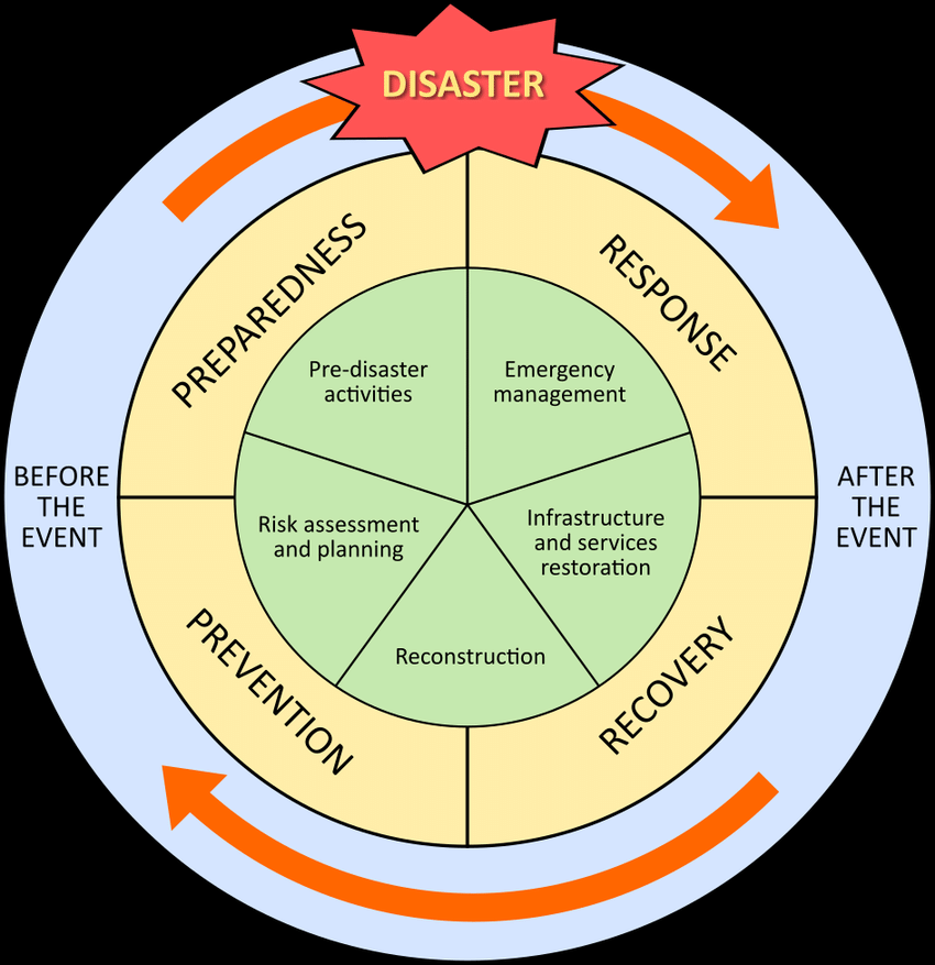
    1. Shift to preventive strategies: Focus on reducing vulnerabilities before disasters occur.
    2. Systematic preparedness: Regular drills, community participation, and pre-emptive relief stocks.
    3. Balanced growth: Infrastructure that respects ecological fragility and integrates climate resilience.

    Conclusion

    The 2025 floods across North India are not isolated accidents but part of a pattern of climate-driven extreme weather. Treating each calamity as “unprecedented” delays learning and perpetuates cycles of loss. Building resilience means moving beyond post-disaster relief to preventive strategies: sustainable infrastructure, landslide mitigation, community drills, and early-warning systems. Unless governance shifts from reaction to anticipation, monsoon seasons will continue to leave trails of destruction.

    PYQ Relevance

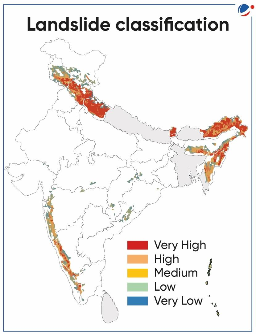
    [UPSC 2019] Disaster preparedness is the first step in any disaster management process. Explain how hazard zonation mapping will help disaster mitigation in the case of landslides.

    Linkage: The 2025 North India floods highlight how slope destabilisation and unchecked construction in Himalayan States amplify landslide risks. Hazard zonation mapping could have guided slope-safe engineering, restricted high-risk land use, and improved early warning. Thus, it directly connects preparedness to mitigation, aligning with the UPSC 2019 question.

  • Sleeping disasters: Cloudbursts

    Cloud Burst:

    A cloudburst is an extremely intense, localized shower, defined by the India Meteorological Department (IMD) as at least 100 mm of rain within one hour over 10 sq km. These events occur due to deep, rapid atmospheric uplift over steep terrain, typical of high-altitude Himalayan regions. They can trigger sudden flash floods and landslides, devastating communities in mountainous regions. The term does not refer to a literal bursting cloud but to rapid precipitation from cumulonimbus clouds, sometimes accompanied by thunder or hail.

    Why was the recent Uttarkashi Disaster not a Cloudburst?

    1. Despite initial reports, Uttarkashi district did not record any cloudburst-level rainfall. Actual rainfall was only light to moderate, ranging from 8 mm to 43 mm on Aug 5, far below the 100 mm/hour threshold
    2. The region lacked weather radar coverage at that altitude, so precise measurements were unavailable and the “cloudburst” classification was premature.
    3. Uttarkashi’s steep, rugged topography, with narrow valleys and loose debris, turned the soil into unstable slopes.
    4. A debris-laden flood, possibly triggered by a glacial lake burst, glacier collapse, or landslide, raced downstream as mud and silt-laden water to hit Dharali village violently.

    Reasons for occurrence of cloudbursts:

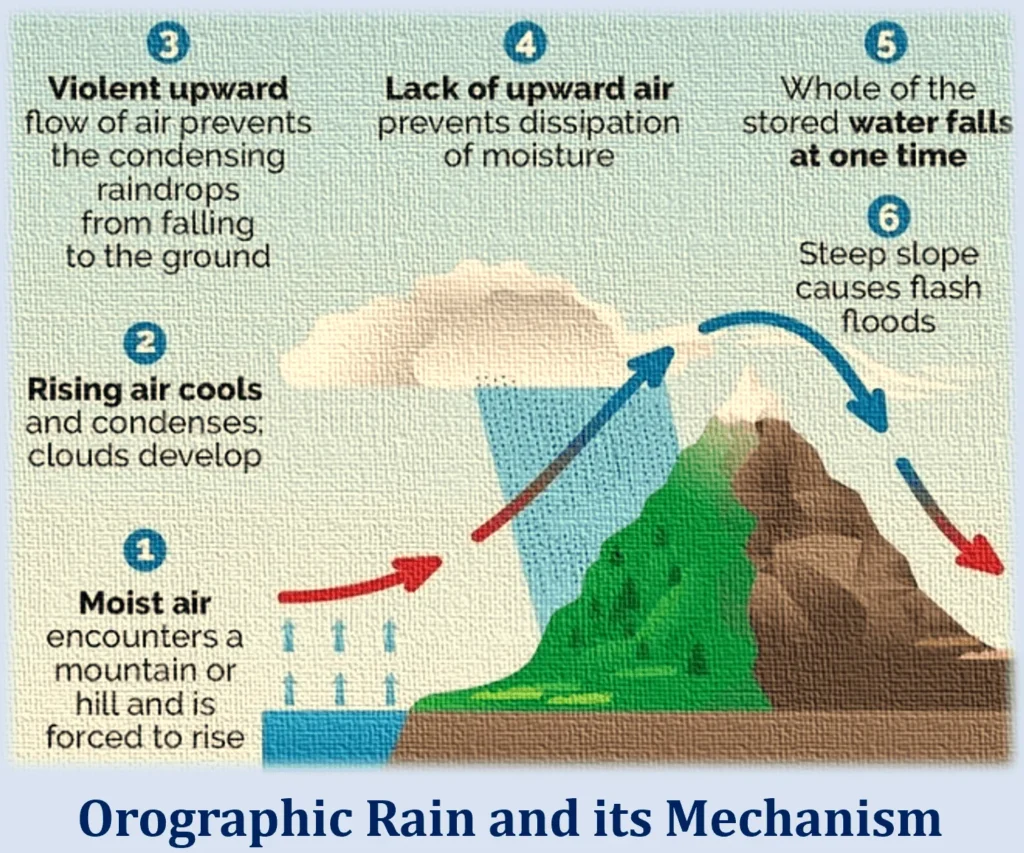
    1. Cloudbursts happen when warm, moist air quickly rises over mountains, cools down, and turns into heavy rain. This process, called orographic lift, causes the air to release a large amount of rain in a short time.
    2. Sudden mixing of warm and cold air
    3. Strong upward air movement (convection) and high moisture in the air at high altitudes

    Why Do Cloudbursts Happen In The Hills?

    1. Topography: Mountains force moist air to rise rapidly, causing sudden cooling and condensation.
    2. Weather Conditions: Warm air with high moisture content meets cooler air at high altitudes. This results in intense convection and localised torrential rain.

    Can cloudbursts be forecast?

    1. The India Meteorological Department (IMD) forecasts rainfall events well in advance, but it does not predict the quantum of rainfall,  in fact, no meteorological agency does.
    2. IMD gives general rainfall forecasts (light, heavy, very heavy), but not exact amounts.
    3. These forecasts are for large areas like districts or states, not specific locations.
    4. Cloudbursts can’t be predicted exactly due to tech limitations and lack of dense instruments.
    5. However, warnings for very heavy rain (which may lead to cloudburst-like events) are given 6–12 hours in advance.

    Impacts of cloud burst:

    1. Flash Floods: The most immediate and destructive impact is the rapid overflowing of rivers and streams, leading to widespread flooding of low-lying areas.
    2. Landslides and Mudslides: The excessive water saturates the soil on slopes, leading to the rapid downward movement of earth, rocks, and debris, causing significant destruction and posing a threat to human lives and infrastructure.
    3. Soil Erosion: The intense rainfall can wash away topsoil, degrading the land and negatively affecting agriculture.
    4. Land Subsidence: The weakening of the ground due to excessive water absorption can cause the sudden sinking or settling of the Earth’s surface
    5. Loss of Life: The suddenness and intensity of cloudbursts often leave little time for evacuation.
    6. Damage to Infrastructure: Roads, bridges, homes, and public utilities can be severely damaged or completely destroyed.

    While the term “cloudburst” often evokes images of catastrophic floods and landslides, it’s crucial to adopt a nuanced approach, avoiding knee-jerk reactions and recognizing that not all instances of heavy rainfall are cloudbursts. While the unpredictable ferocity of cloudbursts remains a formidable challenge, a proactive blend of scientific innovation, infrastructure resilience, and community-centric preparedness offers the compass to navigate their escalating threat, particularly in fragile ecosystems like the Himalayas.

  • [22nd July 2025] The Hindu Op-ed: Water, energy demand spotlights risk of human-induced quakes 

    PYQ Relevance:

    [UPSC 2020] Discuss the geophysical characteristics of Circum-Pacific Zone.

    Linakge: This question is about a region known for earthquakes and volcanoes. The article mainly talks about quakes caused by human activity but also mentions that these usually happen in places already on fault lines or where tectonic plates are shifting—areas like the Circum-Pacific. So, it’s important to understand these natural zones when looking at how human actions might trigger earthquakes.


    Mentor’s Comment:  Human-induced earthquakes are increasingly drawing scientific and public attention, as research shows that human activities like groundwater extraction, dam construction, and fracking can trigger or accelerate seismic activity, particularly in tectonically sensitive regions such as Delhi-NCR, the Western Ghats, and parts of Maharashtra and Kerala.

    Today’s editorial analyses the Issues related to Human-induced earthquakes in India. This topic is important for GS Paper I (Geography), GS Paper II (Governance) and  GS Paper III (Disaster Management) in the UPSC mains exam.

    _

    Let’s learn!

    Why in the News?

    Recent studies in India have highlighted a correlation between excessive groundwater depletion and increased seismic events, especially in Delhi.

    What are human-induced earthquakes?

    • These are earthquakes triggered by human activities rather than natural tectonic movements. Activities like mining, groundwater extraction, building dams, and fracking disturb the earth’s crust, causing seismic activity. Over 700 human-induced quakes have been recorded globally in the last 150 years.


    How do activities like groundwater extraction and dams trigger quakes in India?

    • Groundwater Depletion Weakens Crustal Stability: Excessive extraction of groundwater reduces pore pressure, leading to a shift in stress within the earth’s crust. Eg: In Delhi-NCR, increased seismic activity between 2003–2012 has been linked to excessive groundwater loss.
    • Reservoir-Induced Seismicity (RIS): The weight of large reservoirs exerts additional pressure on underlying faults, triggering quakes. Eg: The 1967 Koynanagar earthquake (magnitude 6.3) was linked to the Koyna Dam in Maharashtra.
    • Water Infiltration into Fault Zones: Water from reservoirs or excessive irrigation can seep deep into fault lines, lubricating them, and making them more likely to slip. Eg: Seismic tremors near Mullaperiyar Dam in Kerala are suspected to be induced due to water infiltration in a seismically sensitive region.
    • Load Variation Due to Filling and Emptying of Dams: Rapid filling or draining of reservoirs changes the stress distribution, causing small or moderate tremors. Eg: In the Himalayan region, such stress changes are a concern for dams like Tehri Dam.
    • Ground Subsidence from Overuse of Aquifers: Excessive groundwater extraction leads to land subsidence, altering the natural equilibrium of stress in the crust. Eg: Regions in North Gujarat have experienced subsidence, making them more vulnerable to fault reactivation and quakes.

    Why is Delhi-NCR prone to quakes from groundwater loss?

    • Rapid Groundwater Depletion Alters Stress Fields: Excessive groundwater extraction reduces the hydrostatic pressure underground, disturbing the natural stress balance in fault zones. This stress redistribution can reactivate dormant faults, triggering seismic activity. Eg: Studies from 2003–2012 show increased microseismic activity in parts of Gurgaon and Faridabad, correlated with falling water tables.
    • Aquifer-Related Land Subsidence: Continuous overuse of aquifers causes the land to sink (subsidence), which can strain the Earth’s crust and disturb nearby fault lines. In Delhi-NCR, land sinking has been recorded in Dwarka, Kapashera, and parts of Noida, increasing quake risk. Eg: A 2021 study by IIT-Kanpur showed that excessive aquifer use led to ground subsidence and elevated seismic hazard.
    • Built-Up Pressure on Seismically Active Faults: Delhi-NCR sits near the Mahendragarh-Dehradun fault and Delhi-Haridwar ridge, making it naturally earthquake-prone. When groundwater is extracted, it weakens the structural resistance of rocks, making nearby active faults more vulnerable. Eg: Minor tremors in Rohini and West Delhi (2020-21) were suspected to be linked to combined stress from tectonics and human activity.

    How does climate change contribute to seismic risks?

    • Melting Glaciers Increase Uplift Pressure: Rapid glacial melt in the Himalayas (due to rising temperatures) reduces surface weight. This triggers isostatic rebound — the crust rises and shifts, which can activate faults beneath. Eg: In Uttarkashi (Uttarakhand), increased seismic activity has been observed near retreating Gangotri Glacier, linked to glacial thinning and uplift.
    • Changing Rainfall Patterns Cause Landslides and Crustal Stress: Intense rainfall and flash floods (exacerbated by climate change) cause rapid groundwater recharge and erosion, disturbing fault stability. Eg: In Kodagu (Karnataka), unusually heavy rains in 2018 triggered landslides and minor tremors due to destabilized slopes and crustal shifts.
    • Sea-Level Rise and Coastal Seismic Pressure: Rising sea levels increase water load on coastal plates, especially in delta regions. This can suppress or activate tectonic stresses near coastlines. Eg: In Sundarbans (West Bengal), changes in sediment load and sea-level rise have raised concerns of future seismic risks in this low-lying, tectonically sensitive zone.
    What are the steps taken by the Indian Government?

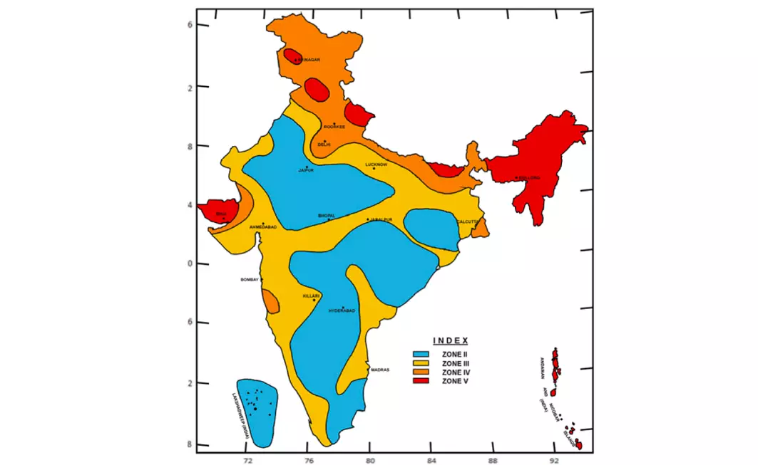
    •  Seismic Zoning and Monitoring: India is divided into four seismic zones (II to V) to prioritize risk-based planning. The National Centre for Seismology (NCS) monitors seismic activity across the country in real-time.
    • Implementation of Earthquake-Resistant Building Codes: The Bureau of Indian Standards (BIS) has issued IS codes for earthquake-resistant construction.
    • Capacity Building and Public Awareness: NDMA and NDRF conduct training, mock drills, and awareness programs in vulnerable areas.

    Way forward: 

    • Integrated Land and Water Management: Promote sustainable groundwater use, recharge practices, and land-use planning to reduce land subsidence and seismic vulnerability.
    • Expand Monitoring and Preparedness: Enhance seismic monitoring networks and public awareness programs to improve early warning systems and disaster resilience.
  • India needs a sincere aircraft accident investigation

    Why in the News?

    The tragic aircraft accident in Ahmedabad on June 12, 2025, has once again thrown a spotlight on India’s deeply flawed aviation accident investigation system.

    Why is the AAIB’s independence in question despite being a statutory body?

    • Operational Control by MoCA: Although the AAIB is technically autonomous, it functions under the Ministry of Civil Aviation (MoCA), which also regulates airlines through the Directorate General of Civil Aviation (DGCA). Eg: In the Air India AI171 crash (2025), both the investigation and regulation were under MoCA’s control, raising concerns of bias and lack of transparency.
    • Leadership Appointments by the Same Authority: The MoCA appoints the heads of both the DGCA and the AAIB, undermining the bureau’s credibility as an independent investigative body. Eg: This centralized appointment structure is unlike the railway sector, where investigations are done by the Commissioner of Railway Safety, independent of the Railway Ministry.
    • Suppression of Uncomfortable Findings: Independent reviews and reports exposing deeper faults are often buried or ignored. Eg: The Air Marshal J.K. Seth Committee Report (1997) identified serious aviation safety issues, but it was never implemented because it told inconvenient truths.

    What systemic flaws affect India’s aviation safety framework?

    • Lack of Functional Independence in Investigations: The Aircraft Accident Investigation Bureau (AAIB) operates under the same ministry (MoCA) that regulates the aviation sector, compromising neutrality. Eg: After the Air India AI171 crash in June 2025, concerns were raised that the investigation might not be impartial due to overlapping roles of MoCA and AAIB.
    • Fragmented Oversight and Regulatory Capture: Aviation oversight in India suffers from poor coordination, limited resources, and influence by the very entities it is supposed to regulate. Eg: The J.K. Seth Committee Report (1997) pointed out such flaws, including regulatory capture, yet its recommendations remain largely unimplemented.
    • Reactive Rather Than Preventive Safety Culture: India’s aviation safety system often responds after accidents occur, rather than identifying and mitigating risks in advance.Eg: Multiple helicopter and flying school crashes in 2024–25 were not adequately investigated for systemic lapses, highlighting the absence of a proactive safety mechanism.

    How does MoCA’s control lead to conflict of interest in aviation oversight?

    • MoCA Controls Both Regulation and Investigation: MoCA oversees the Directorate General of Civil Aviation (DGCA) and also controls the Aircraft Accident Investigation Bureau (AAIB), creating an inherent conflict between promoting aviation and investigating its failures. Eg: In the Air India AI171 crash (2025), MoCA was in charge of both regulating the airline and investigating the crash, raising doubts about impartiality.
    • Lack of Independent Appointments: Senior officials in both DGCA and AAIB are appointed by MoCA, making it difficult for these bodies to act independently or challenge government or airline lapses. Eg: The J.K. Seth Committee (1997) warned about lack of independence due to MoCA’s direct control over top appointments, yet no structural change followed.
    • Investigative Findings May Be Influenced or Suppressed: When the regulator and investigator are under the same authority, reports may be watered down or delayed to avoid political or bureaucratic accountability. Eg: The Kozhikode crash (2020) report’s recommendations were not fully implemented, with experts citing MoCA’s influence in diluting critical findings.

    Why is pilot error often blamed in aviation accident reports?

    • Legally Convenient: Blaming the pilot simplifies legal liability and expedites insurance claims, avoiding lengthy investigations or broader accountability. Eg: In many crash reports, including Aurangabad crash (1993), pilot error was highlighted while structural or operational flaws were downplayed.
    • Shields Other Stakeholders: It protects airlines, maintenance agencies, air traffic control, and the regulator from scrutiny or punishment. Eg: In the Air India Express IX611 case (2018), suspected overloading was ignored while responsibility was pushed toward the flight crew.
    • Systemic Culture of Scapegoating: There’s a lack of a genuine no-blame culture in India’s aviation safety framework. Pilots, even posthumously, become convenient scapegoats. Eg: After the Kozhikode crash (2020), the pilot was quickly blamed, although systemic issues like runway design and poor weather protocols were also contributing factors.

    Way forward: 

    • Ensure Structural Independence of Investigative Bodies: Transfer the AAIB and DGCA out of the Ministry of Civil Aviation’s direct control and make them statutory authorities reporting to Parliament. This will eliminate conflict of interest and promote credible, impartial investigations.
    • Promote a No-Blame Safety Culture: Need to amend existing rules to prevent automatic criminal liability for pilots unless gross negligence is proven (e.g., Rule 19(3) of Aircraft Rules, 1937).

    Mains PYQ:

    [UPSC 2018] Describe various measures taken in India for Disaster Risk Reduction (DRR) before and after signing ‘Sendai Framework for DRR (2015-2030)’. How is this framework different from ‘Hyogo Framework for Action, 2005?

    Linkage: The article explicitly frames an aircraft accident as a “wake-up call” and argues that India needs a system that “prevents failures, and not just manages the damage.” It states, “We cannot keep firefighting. We need a system that prevents failures”. This directly relates to the concept of Disaster Risk Reduction (DRR), which emphasises proactive measures and preparedness over reactive response.

  • ​Monsoon woes: On the southwest monsoon and the northeast

    Why in the News?

    In 2025, the Southwest Monsoon, which plays a vital role in India’s farming economy, brought heavy and destructive rains. Instead of simply starting the farming season, it has caused widespread damage across the northeastern states.

    Why is the northeastern region particularly vulnerable to monsoon-related disasters?

    • Geographical Terrain and River Systems: The Northeast has a complex topography of steep hills and fast-flowing rivers like the Brahmaputra and Barak. These rivers often overflow during monsoon, causing floods and erosion. Eg: In Assam, over 10 major rivers flowed above danger level in June 2025, affecting over 3 lakh people across 19 districts.
    • High and Prolonged Rainfall: The region receives one of the highest average monsoon rainfalls in India, making even a “below normal” monsoondestructive. Eg: Despite IMD predicting lower-than-normal rainfall, Assam, Tripura, and Sikkim faced flash floods and landslidesin May–June 2025.
    • Dual Monsoon Exposure and Fragile Ecology: The region experiences both the southwest monsoon (June–September) and a retreating monsoon (October–December), increasing disaster exposure. The fragile ecology, including deforestation and slope instability, worsens risks. Eg: In North Sikkim, landslides in early June 2025 marooned 1,500 tourists and blocked arterial roads due to incessant rain.

    What is the Dual Monsoon Pattern? 

    Dual Monsoon Pattern refers to the occurrence of two distinct monsoon phases in a year that affect a region, particularly the Northeastern States of India. These are:

    • Southwest Monsoon (June to September):
      This is the primary monsoon season for most of India. The Bay of Bengal branch of the southwest monsoon brings heavy rainfall to the Northeastern States like Assam, Meghalaya, and Arunachal Pradesh.
    • Retreating/Post-Monsoon (October to December):
      This secondary phase brings additional rainfall, especially to Nagaland, Manipur, Mizoram, and Tripura (NMMT region). This is often accompanied by cyclonic storms originating from the Bay of Bengal.

    How does the dual monsoon pattern affect the disaster preparedness of northeastern States?

    • Extended Vulnerability Period: The presence of both the southwest monsoon (June–September) and the retreating/post-monsoon (October–December) leads to a prolonged rainy season, increasing the duration for which states must stay alert and prepared. Eg: In 2023, flash floods affected parts of Meghalaya in both July and November, stretching disaster response capacities.
    • Recurring Strain on Resources: The back-to-back monsoon cycles put continuous pressure on relief infrastructure, emergency services, and budgetary resources, often without adequate recovery time between events. Eg: In Assam, flood shelters and boats used during June floods had to be reactivated again during October rains, delaying repairs and replenishment.
    • Challenges in Long-term Planning: The dual monsoon system makes it harder to plan and execute infrastructure repair, agricultural recovery, and resettlement efforts, as damage may recur within months. Eg: In Arunachal Pradesh, roads repaired after July landslides were again washed away during October rains in 2022, disrupting connectivity repeatedly.

    Why has infrastructure development lagged in the northeastern States compared to the rest of India?

    • Challenging Geographical Terrain: The region is dominated by mountainous landscapes, dense forests, and seismic zones, which make construction of roads, bridges, and railways technically difficult and cost-intensive. Eg: In Sikkim, frequent landslides and narrow mountain roads delay road-widening and highway projects.
    • Security and Strategic Concerns: The presence of international borders with countries like China, Myanmar, and Bangladesh and historical instances of insurgency have led to delays in project execution due to security concerns and administrative restrictions. Eg: The construction of the India-Myanmar-Thailand Trilateral Highway through Manipur has faced repeated delays due to local unrest and law-and-order issues.
    • Low Political and Economic Prioritisation: Compared to other regions, the Northeast has received less investment in infrastructure due to lower population density, limited industrial base, and less political influence at the national level. Eg: States like Nagaland and Mizoram have limited railway connectivity even today, unlike the rapid expansion seen in western and southern India.

    What are the steps taken by the Indian government? 

    • Strengthened Disaster Response and Early Warnings: The government has deployed NDRF units across the Northeast and enhanced IMD’s region-specific alerts for floods and landslides in states like Assam, Sikkim, and Arunachal Pradesh.
    • Infrastructure Development in Vulnerable Areas: Schemes like NESIDS support critical infrastructure such as flood protection embankments and all-weather roads in remote regions of Manipur and Mizoram.
    • Integration into National Disaster Management Frameworks: NDMA conducts capacity building, mock drills, and implements region-specific guidelines for urban flooding and landslide risk in cities like Gangtok and Guwahati.

    What long-term measures are needed to ensure sustainable disaster management in the Northeast? (Way forward)

    • Region-Specific Infrastructure Planning and Investment: Develop climate-resilient infrastructure suited to the region’s fragile ecology, such as landslide-resistant roads, flood-resistant housing, and robust early warning systems. Eg: The installation of a real-time flood monitoring system in the Brahmaputra basin has improved early evacuation in parts of Assam.
    • Integrated Inter-State and Central Coordination Mechanism: Establish a permanent regional disaster coordination body with participation from all Northeast states and the Centre to plan, share resources, and respond collectively to disasters. Eg: A joint task force involving Assam, Arunachal Pradesh, and Meghalaya could improve flood response across shared river systems like the Barak and Brahmaputra.

    Mains PYQ:

    [UPSC 2024] Flooding in urban areas is an emerging climate-induced disaster. Discuss the causes of this disaster. Mention the features of two such major floods in the last two decades in India. Describe the policies and frameworks in India that aim at tackling such floods.

    Linkage: The Bay of Bengal branch of the monsoon reaches the northeastern States first. These areas usually get a lot of rain during the monsoon, even in years when rainfall is lower than normal. Because of this, the region is naturally more prone to problems like flooding, which often comes with such heavy rain. 

  • Danger in the sea: On Kerala and the MSC Elsa 3 sinking

    Why in the News?

    The container ship MSC Elsa 3 sank off the coast of Kochi on May 24, triggering a major environmental and maritime safety crisis that could turn into one of India’s worst maritime pollution disasters.

    What led to the sinking of MSC Elsa 3?

    • Operational Failure at Sea: On May 24, MSC Elsa 3 began tilting off the coast of Kochi due to an unspecified operational problem. Despite attempts by the crew, the ship could not be stabilised.
    • Aging Vessel and Abandonment by Crew: Although structurally considered safe, the ship was nearly 30 years old. The crew abandoned it after unsuccessful efforts to right it, leading to its eventual sinking.
    • Unfavourable Sea Conditions: Monsoon-related rough weather worsened the situation, with containers dislodging and floating, further destabilising the vessel before it sank to a depth of 50 metres.

    Why are the sunken containers considered hazardous?

    • Reactive Chemicals: Some containers hold substances that react dangerously with water, posing immediate chemical and fire hazards. Eg: 12 containers had calcium carbide, which reacts with seawater to produce acetylene gas, a highly flammable and explosive compound.
    • Toxic Leakage: Leaked substances from damaged containers can pollute seawater and pose health hazards to marine life and humans. Eg: A container with rubber solution leaked and reacted with seawater, leading to the appearance of plastic pellets along the Kerala coast.
    • Long-Term Environmental Impact: Chemicals from sunken containers can gradually seep out, causing persistent marine pollution and ecological damage. Eg: If not retrieved, chemicals from these containers may enter the food chain, harming marine biodiversity and impacting fisheries.

    Who handles oil spill response in India?

    The Indian Coast Guard is the nodal agency under the National Oil Spill Disaster Contingency Plan (NOS-DCP).

    How does this incident test India’s maritime disaster readiness?

    • Inter-agency Coordination: Effective disaster response requires smooth coordination between multiple agencies such as the Coast Guard, pollution control boards, and port authorities. Eg: In the 2017 Chennai oil spill, response was delayed due to confusion and poor coordination, leading to severe coastal damage.
    • Emergency Response Infrastructure: The ability to quickly deploy salvage teams, pollution control equipment, and monitoring systems is essential. Eg: After MSC Elsa 3 sank, authorities had time to prepare, making it a critical test of India’s readiness to act swiftlybefore oil or chemicals leak.
    • Policy Implementation and Preparedness: Real-time implementation of national plans and compliance with international protocols demonstrate operational strength. Eg: The National Oil Spill Disaster Contingency Plan (NOS-DCP) designates the Coast Guard as the nodal agency, and this incident checks how well the plan is executed.

    What are the steps taken by the Indian Government? 

    • Activation of Nodal Agencies: The Indian Coast Guard has been designated as the nodal agency under the National Oil Spill Disaster Contingency Plan (NOS-DCP) to coordinate the response. Eg: In the MSC Elsa 3 case, the Coast Guard is actively engaged in monitoring oil leakage and coordinating salvage efforts.
    • Deployment of Salvage Operations: Salvage teams are being engaged following international insurance protocols to prevent further environmental damage. Eg: Authorities have mobilised professional salvers to safely retrieve containers and prevent hazardous leaks from the sunken ship.
    • Monitoring and Cleanup Measures: Environmental agencies have been tasked with identifying and addressing the pollution caused, including plastic pellets and chemical residues. Eg: The Kerala government is coordinating with central pollution control authorities to manage the shoreline impactand protect marine life.

    Way forward: 

    • Strengthen Maritime Hazard Protocols and Container Screening: India must enforce stricter pre-shipment screening of cargo for hazardous materials and mandate real-time tracking of containers carrying reactive or toxic substances.
    • Enhance Rapid Response Infrastructure and Inter-agency Coordination: Develop a unified maritime disaster response framework with clearly defined roles for all agencies — Coast Guard, pollution boards, port authorities, and state governments.

    Mains PYQ:

    [UPSC 2022] Discuss in detail the photochemical smog emphasizing its formation, effects and mitigation. Explain the 1999 Gothenburg Protocol.

    Linkage: The MSC Elsa 3 incident directly involves environmental pollution, specifically marine pollution from hazardous cargo and fuel oil, necessitating mitigation efforts. This question reflects the UPSC’s interest in environmental pollution issues.

  • [27th May 2025] The Hindu Op-ed: Focus on heat-resilience despite the monsoon


    PYQ Relevance:

    [UPSC 2024] What is disaster resilience? How is it determined? Describe various elements of a resilience framework. Also mention the global targets of the Sendai Framework for Disaster Risk Reduction (2015- 2030).

    Linkage: The heat health crisis falls under the broader domain of disaster risk reduction and building resilience, especially considering extreme heat events as climate-induced disasters. It prompts discussion on defining resilience and the frameworks needed, aligning with the call for embedding heat resilience into public health systems.


    Mentor’s Comment: India is going through a serious climate-health crisis as rising temperatures and frequent heatwaves put more pressure on the already stretched public health system. At the recent national conference “India 2047: Building a Climate-Resilient Future,” experts shared not only scientific facts like wet-bulb temperatures but also the real-life struggles of informal workers. This showed how heat stress and social inequality are closely linked. The conference highlighted the need to move beyond isolated emergency care and take united, cross-sector, and fair action to build climate resilience into the way we manage public health.

    Today’s editorial discusses the  serious climate-health crisis as rising temperatures and frequent heatwaves. This content would help in GS Paper II ( Governance & Health Sector) and GS Paper III (Climate change impact).

    _

    Let’s learn!

    Why in the News?

    As extreme weather increases, we need to move from only treating emergencies to preventing problems by focusing on fair and caring public health.

    Why is linking weather alerts with health systems crucial?

    • Enables Timely Preventive Action: Early warning systems allow health workers to prepare and respond before heatwaves lead to medical emergencies. Eg: In Ahmedabad, heat alerts trigger distribution of hydration kits and public advisories, reducing heatstrokecases.
    • Strengthens Community-Level Response: Alerts shared through ASHA workers or local networks can activate door-to-door checks, especially for the elderly and chronically ill. Eg: ASHAs sending WhatsApp messages and visiting vulnerable residents during red alerts.
    • Reduces Burden on Emergency Healthcare: By preventing illness through early interventions (like avoiding midday work, increasing hydration), the pressure on hospitals and emergency services is reduced. Eg: Pre-monsoon planning with meteorological inputs helps health centers stock cooling kits and prepare treatment spaces.

    What is the impact of extreme heat on India’s public health?

    • Rise in Heat-related Illnesses and Deaths: Extreme heat leads to heatstroke, dehydration, and worsens heart and kidney conditions. Eg: According to the National Centre for Disease Control (NCDC), over 25,000 heat-related deaths were recorded in India between 1992 and 2020.
    • Overburdened Healthcare Infrastructure: Hospitals face a surge in emergency cases during heatwaves, straining limited resources. Eg: During the 2022 heatwave, Delhi’s Lok Nayak Hospital reported a 30% increase in patients with heat-related symptoms in just a week.

    How does extreme heat act as a “social injustice multiplier”?

    • Greater Risk to Vulnerable Populations: Outdoor workers, elderly, and slum dwellers suffer disproportionately due to poor shelter and exposure. Eg: A study by the Indian Institute of Public Health (Ahmedabad) found construction workers had a 2.5 times higher risk of heat illness compared to the general population during peak summer.
    • Limited adaptive capacity: Daily wage workers, street vendors, and waste pickers cannot afford to stop working during heatwaves, making them more vulnerable to heat stress and illness. Eg: Construction workers under tin roofs suffer intense heat but have no choice but to continue working.
    • Excludes the marginalised from public guidance: Advice like “stay indoors” or “avoid exertion” is often irrelevant to those who lack shelter, depend on outdoor jobs, or live in overcrowded spaces, highlighting deep systemic inequalities. Eg: A homeless person or a street vendor cannot follow “stay indoors” guidance during a red alert.

    Who can act as frontline heat-safety champions?

    • ASHA Workers and Primary Health Workers: Trained Accredited Social Health Activists (ASHAs) and staff at Primary Health Centres (PHCs) are well-placed to spread awareness, monitor vulnerable groups, and respond early to heat-related illnesses. Eg: An ASHA worker in a rural village sends heat alerts via WhatsApp and conducts door-to-door visits during a heatwave.
    • Health and Wellness Centre Staff: Staff at Health and Wellness Centres can play a key role in educating communities, distributing hydration kits, and advising on preventive measures like staying hydrated and avoiding midday sun. Eg: A nurse at a wellness centre trains local youth on recognizing signs of heat stress and first-aid response.

    What are the steps taken by the Indian Government? 

    • Development of Heat Action Plans (HAPs): The government, in collaboration with local bodies and NGOs, has promoted city-level Heat Action Plans to reduce heat-related mortality through early warnings, public awareness, and cooling strategies. Eg: The Ahmedabad Heat Action Plan (2013) includes early warning systems, public cool spaces, and training for health workers.
    • Integration with Meteorological Services: India Meteorological Department (IMD) provides heat alerts, which are increasingly being integrated into local health response systems to trigger preventive action. Eg: Heat alerts in Odisha are linked to ASHA worker messaging and hydration kit distribution before peak summer.
    • Policy Push for Climate-Resilient Health Systems: The National Action Plan on Climate Change and Human Health (NAPCCHH) encourages health systems to be climate-ready by building infrastructure, developing clinical protocols, and training staff. Eg: Health ministries now issue advisories on heat stress, including guidance on modifying medication for chronic patients during heatwaves.

    What preventive steps can make India’s health system heat-resilient? (Way forward)

    • Strengthening Primary Health Infrastructure: Equip primary health centres, Health & Wellness Centres, and ASHA workers with training and protocols to identify and respond to heat-related illnesses. Eg: Trained ASHA workers in rural Gujarat conduct door-to-door checks during heat alerts and share hydration tips via WhatsApp groups.
    • Integrating Heat Risk into Chronic Disease Care: Clinicians should adjust medications, provide heat safety counselling, and track high-risk patients like those with heart or kidney conditions during summer. Eg: In Delhi, doctors monitor diabetic patients more closely during red alerts and advise them on avoiding midday exposure.
    • Standardising Clinical Protocols for Heat Illness: Create and implement national clinical guidelines for diagnosing and treating heatstroke and heat stress, including summer drills and heat corners in hospitals. Eg: Rajasthan hospitals now stock cooling kits and have designated heat response units during summer months.
  • Akshvi Platform for Disaster Damage Reporting

    Why in the News?

    India has introduced Akshvi, a unique e-digital wallet aimed at assisting in disaster relief and improving the accuracy of loss reporting.

    About Akshvi: The E-Digital Wallet for Disasters

    • Akshvi (Aapda Kshati Vivaran) is a unique e-digital wallet developed by SEEDS India to assist disaster-stricken communities in India.
    • The platform allows people to self-report economic and non-economic losses during climate-induced events.
    • It bridges the data gap in disaster reporting and enhancing relief distribution and climate resilience.

    Key Features of Akshvi:

    • Self-Reporting Mechanism: It enables affected communities to log their losses during disasters such as floods, droughts, heatwaves, and landslides, ensuring accurate and timely assessments.
    • Localized Data Collection: The platform collects hyperlocal data, which is vital for tailoring disaster management strategies and relief efforts to the specific needs of affected communities.
    • User-Friendly Interface:
      • IVRS: Allows voice recording of losses.
      • WhatsApp Chatbot: For tech-savvy users to log data.
      • Assisted Data Entry: Available for those needing help with information entry.
    • Traceability: The platform tracks the progress of relief, ensuring that aid reaches the affected households transparently.
    • Integration with Government Schemes: Akshvi’s data links to social welfare schemes and index-based insurance programs, improving disaster response efforts.
    [UPSC 2004] In which one of the following countries did hundreds of people die in 2004 due to Tropical Storm Jeanne?

    Options: (a) Colombia  (b) Haiti (c) Sudan (d) Ghana


  • [21st April 2025] The Hindu Op-ed: Tackle heatwaves with short- and long-term measures

    PYQ Relevance:

    [UPSC 2024] What is disaster resilience? How is it determined? Describe various elements of a resilience framework. Also mention the global targets of the Sendai Framework for Disaster Risk Reduction (2015- 2030).

    Linkage: Heatwaves are increasingly recognized as severe weather events and fall under the purview of disaster management. This question directly asks about disaster resilience and its framework, which is crucial for tackling heatwaves. Building resilience to heatwaves involves both short-term preparedness (early warning systems, public awareness) and long-term adaptation (infrastructure changes, social safety nets) as highlighted in the article. The Sendai Framework’s targets are also relevant for setting goals in reducing heatwave-related mortality and morbidity.


    Mentor’s Comment:  According to the World Meteorological Organization, 2024 was the hottest year ever recorded, with global temperatures about 1.55°C higher than in pre-industrial times. In India, December 2022 was the hottest December since temperature records began in 1901. Overall, India has seen more heatwaves in the last 20 years compared to the 20 years before that.

    Today’s editorial talks about the current heatwave situation and its effects. This topic is useful for GS Paper 3 in the UPSC Mains exam.

    _

    Let’s learn!

    Why in the News?

    On March 15, some states and cities in India faced their first severe heatwave of 2025 — about 20 days earlier than the first severe heatwave in 2024.

    What are the key health and socio-economic effects of heatwaves in India?

    • Health Impacts (Heat Stress): Heatwaves in India lead to heat stress, which occurs when the outside temperature approaches the body’s normal temperature of 37°C. This hampers the body’s ability to release internal heat, leading to a range of health problems including kidney failure, liver damage, and brain-related issues, sometimes resulting in death. Eg, the 2015 heatwave in Andhra Pradesh and Telangana caused over 2,000 deaths due to extreme temperatures.
    • Impact on Agriculture and Livestock: Heatwaves negatively affect the farming sector, reducing crop yields and livestock production due to heat stress. Eg, the 2020 heatwaves led to significant crop damage, particularly in areas like Punjab and Haryana, where farmers saw a drop in wheat and paddy production, impacting food security.
    • Socio-Economic Consequences: Heatwaves result in loss of productivity, particularly in labor-intensive sectors like agriculture, construction, and outdoor work. This causes economic losses as workers lose work hours, and agricultural outputs decline. Eg, in 2023, heat stress led to an estimated loss of 6% of work hours in India, contributing to reduced personal incomes and affecting national GDP.

    Why is heat stress an equity issue for vulnerable groups?

    • Disproportionate Impact on the Poor: Vulnerable groups such as the poor face the worst effects of heat stress due to limited access to resources like cooling systems, healthcare, and safe working conditions. Eg, in urban slums with poor infrastructure, people are exposed to higher temperatures both indoors and outdoors, leading to greater health risks compared to wealthier populations with air-conditioned homes.
    • Gendered Impact: Women, especially in rural and lower-income areas, are more affected by heat stress due to cultural norms that restrict their mobility and tasks, such as working in kitchens or wearing heavy clothing. Eg, women in rural India may have to work in the kitchen during peak heat hours, further increasing their risk of heat-related illnesses.
    • Impact on Migrant Workers and Informal Sector Employees: Migrants and workers in the informal sector often lack access to benefits such as paid leave, healthcare, or workplace protections, making them more vulnerable to heat stress. Eg, construction workers in cities like Delhi and Mumbai suffer from heat-related illnesses as they work outdoors without proper protection, and they cannot afford to miss work, leading to further health deterioration.

    When did India begin implementing Heat Action Plans (HAPs), and how have they evolved over the years?

    • Initial Implementation in 2013: India began implementing Heat Action Plans (HAPs) in 2013 when Ahmedabad, Gujarat, became the first city in Asia to develop a municipal Heat Action Plan. The plan focused on early heatwave predictions, public awareness, and health system preparedness. Eg, Ahmedabad’s HAP helped reduce heat-related mortality by alerting vulnerable communities and healthcare systems ahead of heatwaves.
    • Expansion to Other Cities (2014-2018): After the success in Ahmedabad, other cities and states began developing their own heat action plans. By 2018, over 20 Indian cities and states had implemented their HAPs, adapting them based on local vulnerabilities. Eg, cities like Chennai and Hyderabad incorporated heat action strategies, including cooling shelters and awareness campaigns.
    • National Coordination (2018): In 2018, the National Programme on Climate Change and Human Health (NPCCHH) was introduced to provide a unified approach, coordinating heat advisories and other health-related information across the country. Eg, the National Disaster Management Authority (NDMA) began issuing nationwide heatwave alerts to help states and cities prepare for extreme heat events.
    • Focus on Long-Term Measures (2020-Present): Recent iterations of HAPs have emphasized long-term preventive measures, such as urban greening, reflective rooftops, and improved building materials to reduce heat retention. Eg, several cities, like Delhi, are promoting cool roof policies, encouraging the use of heat-reflective materials on buildings to reduce urban heat islands.

    How can India improve the effectiveness and implementation of Heat Action Plans at the state and city levels?

    • Tailor Plans Based on Local Vulnerability: India can improve HAP effectiveness by ensuring that each state and city develops plans based on specific local vulnerabilities such as geography, socio-economic factors, and infrastructure. Eg, coastal cities like Mumbai may need strategies focusing on humidity and high temperatures, while inland cities like Jaipur might need to focus more on extreme heat and dry conditions.
    • Incorporate Real-Time Data and Predictive Technology: HAPs can be enhanced by using real-time data on temperature, humidity, and wind speed to improve forecasting accuracy and timely alerts. Eg, the use of satellite data and ground-based sensors in cities like Pune has allowed for more accurate predictions of heat stress, enabling better preparedness and quicker responses during heatwaves.
    • Strengthen Collaboration Between Stakeholders: Successful implementation of HAPs requires coordination between government bodies, local authorities, public health institutions, NGOs, and community organizations. Eg, in Ahmedabad, the city’s HAP involved collaborations between municipal authorities, public health officials, and non-governmental organizations, which significantly contributed to the reduction in heat-related deaths.
    • Focus on Long-Term Urban Planning and Infrastructure: HAPs should integrate long-term urban development strategies that mitigate heat in the built environment, such as increasing green spaces, promoting cool roofs, and using reflective materials for buildings. Eg, Chennai’s initiative to plant more trees and create shaded public spaces has helped reduce heat in urban areas, making the city more resilient to heatwaves.
    • Ensure Inclusivity and Equity in Response Measures: HAPs should ensure that vulnerable populations such as informal sector workers, elderly, and marginalized communities are given special attention during heatwaves. Eg, Delhi’s HAP has included mobile cooling units and shelters for the homeless, along with providing water points and health services in areas with high concentrations of migrant workers and low-income groups.

    What is the current situation regarding the occurrence of heat waves in India?

    • Increased Frequency of Heatwave Days: The number of heatwave days in India has risen over the past decade. In 2022, approximately 121 heatwave days were recorded across the country, a decrease from the previous year but still indicative of a growing trend.
    • Record-Breaking Temperatures: In May 2024, northern India experienced severe heatwaves, with temperatures reaching up to 49.1°C in New Delhi. Over 37 cities reported temperatures exceeding 45°C, leading to at least 56 confirmed deaths and 25,000 suspected cases of heatstroke.
    • Projections of Future Heatwave Intensification: Future projections indicate a significant increase in heatwave frequency due to climate change. Under the RCP 4.5 scenario, the frequency of heatwaves in India is expected to increase by a factor of 4 to 7 in the mid-term and by 5 to 10 times in the long-term future.

    Way forward: 

    • Strengthen Policy Integration and Local Capacities: Integrate Heat Action Plans into urban planning and disaster management policies, while building capacity at local levels for climate-resilient infrastructure and real-time response systems.
    • Targeted Support for Vulnerable Groups: Prioritize inclusive measures such as community cooling centers, mobile health units, and social safety nets to protect informal workers, elderly, and low-income populations from heat-related risks.
  • Himalayan tragedy: On avalanches in the Himalayan States

    Why in the News?

    Earlier this week, the Indian Army and Indo-Tibetan Border Police rescued 23 workers trapped under snow and ice after an avalanche in Mana village, Uttarakhand.

    What were the key challenges faced by the rescue teams during the avalanche operation in Mana Village?

    • Harsh Weather Conditions: The rescue teams operated under heavy snowfall and extreme cold at an elevation of 10,500 feet above mean sea level.
    • Blocked Access Routes: Snow-blocked roads required the use of helicopters for evacuation, complicating logistics and delaying rescue efforts.
    • Physical Exhaustion: Rescuers worked in near-continuous 60-hour shifts, demanding immense physical and mental stamina.
    • Buried Structures: Containers housing workers were buried under several feet of snow, ice, and rock, making detection and extraction challenging.
    • Limited Visibility and Navigation: Poor weather conditions hindered visibility, requiring the use of advanced technology like drone-based detection systems.

    Why is Mana village particularly vulnerable to avalanches and other natural disasters?

    • High-Altitude Location: Situated at 10,500 feet above sea level in the upper Himalayas, the village experiences heavy snowfall and extreme weather, increasing the risk of avalanches. Example: The recent avalanche buried containers under several feet of snow, making rescue operations challenging.
    • Geological Instability: The Himalayan region is tectonically active, making the terrain prone to landslides, avalanches, and other natural hazards. Example: Frequent landslides during the monsoon season disrupt roads and infrastructure in Uttarakhand.
    • Seasonal Climate Extremes: Harsh winters with severe snow accumulation create unstable snowpacks that can trigger avalanches. Example: Villagers traditionally migrate to lower areas like Gopeshwar during winter to avoid extreme weather risks.
    • Construction and Human Activity: Ongoing infrastructure projects, such as road-building by the Border Roads Organisation (BRO), disturb the fragile environment and increase disaster risks. Example: Workers were caught in an avalanche while working on a BRO construction site.
    • Proximity to Glacial Zones: Close to glacial areas where melting ice and shifting snowpacks heighten the probability of snow slides. Example: Melting glaciers in the region have previously triggered flash floods, like the 2021 Chamoli disaster.

    What lessons can be learned from other hazardous environments? 

    • Enhanced Shelter Design for Safety: Use reinforced, insulated shelters designed to withstand extreme weather and heavy snow loads, similar to Antarctic research stations. Example: Antarctic research bases like the Amundsen-Scott Station use elevated, modular designs to prevent snow burial and provide long-term safety.
    • Advanced Early Warning Systems: Implement real-time monitoring using satellite imaging, drones, and weather forecasting to detect potential avalanches and other hazards. Example: Switzerland’s avalanche warning system uses advanced sensors and weather models to alert communities and workers in mountainous areas.
    • Comprehensive Safety Protocols and Training: Provide specialized safety training, emergency drills, and evacuation plans to workers in high-risk zones. Example: Oil platforms in the Arctic conduct regular safety drills and have rapid-response systems for extreme weather emergencies.

    How could better infrastructure and safety measures reduce the risks faced by workers in high-altitude, disaster-prone areas? (Way forward)

    • Improved Worker Shelters and Living Conditions: Construct insulated, avalanche-resistant shelters with emergency exits and heating systems to protect workers from harsh weather. Example: The Siachen Glacier military base uses reinforced prefabricated shelters designed to withstand extreme snow and sub-zero temperatures.
    • Deployment of Real-Time Monitoring and Early Warning Systems: Use geospatial technology, drones, and automated weather stations to track snow accumulation and predict avalanches. Example: Japan’s snow monitoring system uses remote sensors to provide early warnings, reducing avalanche risks in mountainous areas.
    • Enhanced Emergency Response Infrastructure: Establish permanent rescue facilities with specialized equipment (e.g., thermal detectors and rapid evacuation routes) for quicker disaster response. Example: The Alps region in Europe maintains well-equipped avalanche rescue stations, ensuring faster response times and reducing casualties.

    Mains PYQ:

    Q Differentiate the causes of landslides in the Himalayan region and Western Ghats. (UPSC IAS/2021)