💥Join UPSC 2027,2028 Mentorship (July Batch) + XFactor Notes & Microthemes PDF

Subject: Geographical Features

  • Delamination of the Indian Plate

    Why in the News?

    Recent studies reveal that the Indian Plate is splitting into two, with the lower part detaching and sinking into the Earth’s mantle, a process called delamination, as published by the American Geophysical Union.

    About Delamination:

    • Delamination in tectonic plates refers to the process where the lower part of a continental plate, including the lower crust and/or lithospheric mantle, splits and sinks into the Asthenosphere.
    • This process is driven by density differences and can lead to rapid uplift, changes in stress regimes, and altered magmatism.
    • It can occur in various tectonic settings, including compressional zones, subduction zones, and intraplate regions. 
    • The denser lower part of the plate, including the lower crust and/or lithospheric mantle, is less buoyant than the less dense asthenosphere, leading to sinking.
    • High temperatures can also weaken the lithosphere and facilitate delamination.

    Delamination of the Indian Plate

    Indian Plate and Its Splitting:

    • The Indian Plate has been colliding with the Eurasian Plate for about 60 million years, causing the formation of the Himalayas and influencing regional seismic activity.
    • It is shifting northward at a rate of approximately 5 cm per year..
    • The lower, denser part of the Indian Plate is detaching and sinking into the Earth’s mantle.
    • This may lead to increased seismic activity due to shifts in tectonic stress.
    • In regions like the Himalayan collision zone, delamination results in fractures that increase stress in the Earth’s crust, raising the likelihood of seismic events.
    [UPSC 2004] Consider the following geological phenomena:

    1. Development of a fault 2. Movement along a fault 3. Impact produced by a volcanic eruption 4. Folding of rocks Which of the above cause earthquakes?

    Options:

    (a) 1, 2 and 3 (b) 2 and 4 (c) 1, 3 and 4 (d) 1, 2, 3 and 4


  • Study finds a Shift in Peak Time of Maximum Rainfall

    Why in the News?

    A recent study published in Geophysical Research Letters revealed changes in the amount and timing of rainfall using GSMaP Data between 2001-2010 and 2011-2020.

    About Global Satellite Mapping of Precipitation (GSMaP)

    • GSMaP is a specialized precipitation product developed through collaboration between ISRO (Indian Space Research Organisation) and JAXA (Japan Aerospace Exploration Agency).
    • It provides high-resolution precipitation data with a 0.1° x 0.1° grid and one-hour temporal resolution, focusing on the Indian subcontinent since March 2000.
    • The data supports rainfall trend analysis, climate modelling, and water resource management.

    Study finds a Shift in Peak Time of Maximum Rainfall

    Key Findings of the Study:

    • Rainfall Trends:
      • West-Central India: Increased daily rainfall (2 mm/day) from 2011-2020 compared to 2001-2010.
      • Eastern India: A decrease of ~1 mm/day in rainfall during the same period.
      • Regional Shifts: Northeastern and eastern India saw decreased rainfall, while the Indo-Gangetic Plain and southern India experienced increases.
    • Vegetation & Soil Moisture:
      • West-Central India saw an increase in vegetation (NDVI from 0.2 to 0.4) and soil moisture linked to increased rainfall.
      • Eastern India had decreased soil moisture during the same period.
    • Shifts in Peak Rainfall Timing:
      • Indo-Gangetic Plain: Peak rainfall advanced by 2-4 hours.
      • West-Central India: Peak rainfall delayed by 1-2 hours.
    • Factors responsible for this Shift:
      • Higher soil moisture supports rainfall, while reduced moisture, particularly in eastern India, decreases rainfall.
      • Higher aerosol concentrations in polluted areas like the Indo-Gangetic Plain lead to earlier rainfall peaks.
      • Changes in atmospheric circulation, topography, and coastal influences also affect rainfall distribution and timing.
    [UPSC 2012] Consider the following statements:

    1. The duration of the monsoon decreases from southern India to northern India.

    2. The amount of annual rainfall in the northern plains of India decreases from east to west.

    Which of the statements given above is / are correct?

    (a) 1 Only (b) 2 Only (c) Both 1 and 2 (d) Neither 1 nor 2


  • What is Atmospheric River?

    Why in the News?

    Earlier this month, severe weather in the United States, including heavy rainfall, strong winds, and thunderstorms, was caused by an Atmospheric River.

    What is an Atmospheric River?

    • An atmospheric river is a narrow, fast-moving band of moisture and wind that transports large amounts of water vapor across vast distances.
    • They form when large-scale weather patterns align, creating channels of moisture transport from tropical oceans, guided by low-level jet streams toward the coast.
    • They typically span 402-606 km in width and can extend over 1600 km in length.
    • The most powerful atmospheric rivers transport moisture equivalent to the Mississippi River’s flow.
    • Example: The Pineapple Express, a well-known atmospheric river, transports moisture from Hawaii to the West Coasts of the U.S. and Canada.
    • The intense rainfall from atmospheric rivers leads to flooding, mudslides, and infrastructure damage, with wind speeds comparable to hurricanes.

    Impact and Climate Change:

    • Rising global temperatures cause more water to evaporate, and warmer air can hold more moisture.
    • For every 1°C increase, the atmosphere can hold 7% more moisture, leading to stronger storms.
    • Research indicates such events will likely grow longer and more intense.
    [UPSC 2023] With reference to the Earth’s atmosphere, which one of the following statements is correct?

    (a) The total amount of insolation received at the equator is roughly about 10 times of that received at the poles.

    (b) Infrared waves are largely absorbed by carbon dioxide that is concentrated in the upper atmosphere.

    (c) Infrared waves are largely absorbed by water vapour that is concentrated in the lower atmosphere.  

    (d) Ultraviolet rays are absorbed by the ozone layer lying in the ionosphere.


  • What are Mesoscale Convective System (MCS)?

    Why in the News?

    A recent study in Nature Geoscience suggests that soil moisture levels could help predict severe thunderstorms, like mesoscale convective systems (MCSs), especially in regions like India.

    About Mesoscale Convective Systems (MCS):

    • MCSs are larger than individual thunderstorms but smaller than larger weather systems like cyclones.
    • They typically cover areas between 100 to 1,000 km in diameter.
    • They form when warm, moist air rises, creating storms that feed off each other, growing in size and intensity as they move across the region.
    • They can cause flash floods, damaging winds, and severe thunderstorms, and are often responsible for large-scale weather events.
    • In tropical regions, MCSs account for 50 to 90 % of total rainfall, making them a major cause of severe weather-related damage.
    • A notable example is the March 2024 thunderstorm in West Bengal, which caused significant property damage and loss of life.

    Soil Moisture’s Role in MCS as per the Study:

    • Shifts in soil moisture can be detected two to five days before the formation of storms, providing critical lead time for early warnings in vulnerable regions.
    • Contrasting soil moisture levels over large areas (hundreds of kilometers) lead to changes in atmospheric conditions, including A notable example is the March 2024 thunderstorm in West Bengal, which caused significant property damage and loss of life.
    • Larger contrasts in moisture content between dry and wet regions cause greater temperature differences, which in turn lead to changes in wind direction and speed.
    • These variations contribute to turbulence, making storms more intense and spreading rainfall over a wider area.
    [UPSC 2013] During a thunderstorm, the thunder in the skies is produced by the

    1. meeting of cumulonimbus clouds in the sky 2. lightning that separates the nimbus clouds 3. violent upward movement of air and water particles

    Select the correct answer using the codes given below:

    (a) 1 only (b) 2 and 3 (c) 1 and 3 (d) None of the above produces the thunder


  • The crisis in India’s cotton production, and what can help

    Why in the News?

    India’s cotton production has dropped by 25% over the last 10 years because of the pink bollworm. Some seed companies have created new genetically modified cotton varieties that can resist this pest, but government rules are delaying their approval and use.

    Why has cotton output fallen despite Bt cotton’s earlier success?

    • Resistance Development in Pests: The pink bollworm (PBW), a monophagous pest, developed resistance to Bt cotton toxins (cry1Ac and cry2Ab) over time. Eg: A study published in Nature showed PBW resistance by 2014, just 12 years after Bt cotton’s introduction.
    • Pest Adaptability and Short Life Cycle: PBW’s short life cycle (25–35 days) allows multiple generations in one crop season, accelerating resistance buildup. Eg: In central India, PBW reached economic threshold levels by 2014, impacting yields.
    • Yield Stagnation and Decline: The national average lint yield rose to 566 kg/ha in 2013–14 but has fallen to around 436–437 kg/ha in recent years. Eg: This drop mirrors increased pest pressure and reduced effectiveness of Bt technology.
    • Increased Import Dependence: Falling domestic production has led to India importing more cotton than it exports. Eg: In 2024–25, imports are projected at 30 lakh bales vs exports of 17 lakh bales.
    • Lack of New GM Approvals: Regulatory and political hurdles have stalled the approval of next-gen GM cotton hybrids resistant to PBW. Eg: No new GM cotton hybrid has been commercialised since Bollgard-II in 2006.

    How has the pink bollworm turned India into a net cotton importer?

    • Destruction of Cotton Bolls and Lint Quality: PBW larvae bore into cotton bolls, feeding on seeds and lint, reducing both yield and fibre quality. Eg: This led to a production drop from 398 lakh bales (2013–14) to just 294 lakh bales (2024–25 projected) — the lowest since 2008–09.
    • Resistance to Bt Cotton: PBW developed resistance to the Bt toxins (cry1Ac and cry2Ab) used in GM cotton, making current hybrids ineffective. Eg: Resistance was first noted in central India around 2014, eventually spreading to southern and northern zones.
    • Decline in Exports, Rise in Imports: As production fell and quality declined, exports dropped and imports surged. Eg: In 2024–25, India is expected to import 30 lakh bales but export only 17 lakh bales, reversing its earlier status as a net exporter.

    Which new genetic technologies are Indian seed companies using to combat PBW resistance in cotton crops?

    • Introduction of Novel Bt Genes: Companies are using Bt genes not previously deployed in India to overcome existing PBW resistance. Eg: Bioseed Research India is conducting trials with its ‘cry8Ea1’ gene-based hybrid under the proprietary BioCotX24A1 event.
    • Use of Synthetic Bt Genes: Synthetic versions of Bt genes are engineered to enhance toxicity and overcome pest resistance. Eg: Rasi Seeds has developed hybrids expressing a synthetic cry1c gene for improved resistance to PBW.
    • Deployment of Chimeric Bt Genes: Chimeric genes combine segments of multiple Bt genes to create a novel protein with broader insecticidal action.Eg: Ankur Seeds, in collaboration with NBRI, is trialing cotton hybrids using a chimeric Bt protein from Event 519.

    When did the pink bollworm start crossing the economic threshold level in various cotton-growing zones of India?

    • Central Zone (Maharashtra, Gujarat, Madhya Pradesh): PBW crossed the ETL around 2014, marking the beginning of widespread yield loss in the heartland of cotton production. Eg: Farmers in Maharashtra began reporting severe PBW damage post-2014 despite using Bt cotton.
    • Southern Zone (Telangana, Andhra Pradesh, Karnataka, Tamil Nadu): The pest breached the ETL by 2017, affecting the second major cotton belt in the country. Eg: Telangana experienced major crop losses during the 2017–18 season due to PBW infestation.
    • Northern Zone (Punjab, Haryana, Rajasthan): PBW reached ETL in the northern states by 2021, completing its spread across all major cotton-growing regions. Eg: In 2021, Haryana reported pink bollworm infestation even in previously unaffected areas.

    How are regulatory hurdles affecting the commercialisation of new GM cotton hybrids in India?

    • Lengthy Approval Process: Multi-stage field trials (event selection, BRL-1, BRL-2) take years before commercial approval is granted. Eg: Bioseed’s ‘cry8Ea1’ GM cotton is still in BRL-1 trial phase, needing further years of testing before release.
    • Lack of New GM Approvals Since 2006: No new GM cotton hybrid has been approved for commercial cultivation since Monsanto’s Bollgard-II in 2006. Eg: Despite several companies developing PBW-resistant varieties, commercialisation remains stalled.
    • Opposition from States and Activist Groups: State-level permissions and activist resistance delay or block field trials, affecting research and rollout. Eg: Rasi Seeds and Ankur Seeds await approvals for first-year trials amid regulatory scrutiny and local objections.

    What advantages does India have in cotton production and trade?

    • Favorable Climate and Large Cotton-Growing Area: India has a vast area suitable for cotton cultivation, with diverse agro-climatic zones supporting long growing seasons. Eg: India is the world’s largest cotton producer, with major states like Maharashtra, Gujarat, and Telangana contributing significantly.
    • Low Export Duties Compared to Other Countries: India faces lower tariffs on its textile exports in key markets like the US, making its products more competitive. Eg: Under the US’s “reciprocal tariff” policy, Indian textile exports face only 27% duty, while China’s face 54% and Bangladesh’s 37%.

    Way forward: 

    • Accelerate Regulatory Approvals for Next-Gen GM Cotton: The government should streamline and fast-track the approval process for new GM hybrids with novel, synthetic, or chimeric Bt genes to restore cotton productivity and pest control efficacy. Eg: Timely clearance of Bioseed’s cry8Ea1 and Rasi’s synthetic cry1c cotton hybrids can help tackle PBW resistance.
    • Promote Integrated Pest Management (IPM) and Farmer Awareness: Combine genetic solutions with IPM strategies—crop rotation, pheromone traps, and timely pesticide use—to delay resistance buildup. Launch nationwide farmer education programs on early detection and field hygiene. Eg: Maharashtra’s IPM pilot schemes have shown promise in reducing PBW infestations when practiced consistently.

    Mains PYQ:

    [UPSC 2021] What are the present challenges before crop diversification? How do emerging technologies provide an opportunity for crop diversification?

    Linkage:  Vulnerability of a monoculture system relying heavily on Bt cotton, crop diversification could be a strategy to reduce dependence on a single crop and potentially break pest cycles, although the article focuses on technological solutions within cotton itself.

  • Massive Earthquake hits Myanmar and Thailand

    Why in the News?

    A powerful 7.7 magnitude earthquake struck Myanmar, with its epicentre near Mandalay, the country’s second-largest city.

    Massive Earthquake hits Myanmar and Thailand

    What caused the Earthquake in Myanmar?

    • Myanmar is situated between the Indian Plate and the Eurasian Plate, which makes the region seismically active.
      • The Sagaing Fault, running from north to south through Myanmar, marks the boundary of these plates.
      • It is an active fault line that has caused significant earthquakes in the past, including a 7.9 magnitude earthquake in 1912 and a 6.9 magnitude earthquake in 2016.
    • The Indian Plate was moving northward along the Sagaing Fault relative to the Eurasian Plate. The friction and stress built up along this fault led to a sudden release of energy, resulting in the earthquake.
    • The earthquake’s epicentres was located 17.2 km from Mandalay, Myanmar’s second-largest city, at a depth of just 10 km.

    Why are Shallow Earthquakes more destructive?

    • Proximity to the Surface: Shallow earthquakes (less than 70 km deep) cause intense shaking. For example, the Myanmar earthquake occurred at 10 km, leading to rapid, forceful seismic waves and extensive damage.
    • Energy Release: Shallow earthquakes retain more energy in seismic waves, causing stronger surface shaking and greater destruction.
    • Higher Intensity: Shallow quakes produce higher intensity shaking, resulting in more structural damage compared to deeper quakes, where seismic waves lose energy.
    • Aftershocks: Shallow earthquakes often lead to more intense aftershocks, further damaging already weakened structures. The Myanmar earthquake had aftershocks, including one with magnitude 6.4.

    Back2Basics: Earthquake and Related Terminologies

    • Earthquake is a sudden shaking of the ground caused by energy release from tectonic plate movements or volcanic activity, generating seismic waves.
    • Key Terminologies:
      • Focus (Hypocenter): The point inside the Earth where the earthquake originates, deep beneath the surface.
      • Epicenter: The point on the Earth’s surface directly above the focus, usually the most affected area.
      • Seismic Waves: Waves that carry the energy released during an earthquake and cause ground shaking.
      • Fault: A crack or fracture in the Earth’s crust where movement occurs, often causing earthquakes.
      • Magnitude: A measure of the earthquake’s size or energy, commonly measured on the Richter scale.
      • Intensity: The strength of shaking at specific locations, measured by the Modified Mercalli Intensity (MMI) scale.

    Types of Earthquake Waves:

    • Body Waves: Travel through the Earth’s interior, detected first by seismographs.
      • Primary Waves (P-Waves): Fastest, compression waves that move through solids and liquids.
      • Secondary Waves (S-Waves): Shear waves, slower than P-waves, that move through solids only.
    • Surface Waves: Travel along the Earth’s surface, slower but cause more damage.
      • Love Waves: Move side-to-side horizontally, causing significant damage.
      • Rayleigh Waves: Cause elliptical ground motion, similar to ocean waves, very destructive.


    [UPSC 2021] Consider the following statements:

    1. In a seismograph, P waves are recorded earlier than S waves.

    2. In P waves, the individual particles vibrate to and fro in the direction of waves propagation whereas in S waves, the particles vibrate up and down at right angles to the direction of wave propagation.

    Which of the statements given above is/are correct?

    (a) 1 only (b) 2 only (c) Both 1 and 2 (d) Neither 1 nor 2


  • 50 Years of Farakka Barrage

    Why in the News?

    It was nearly 50 years ago, that India had completed the construction of the Farakka Barrage.

    About Farakka Barrage

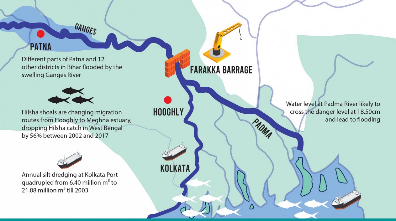
    • The Farakka Barrage is located on the Ganges River in Murshidabad District, West Bengal, India, about 18 km from the Bangladesh border.
    • The barrage measures 2,304 meters (7,559 feet) in length.
    • Its construction began in 1962 and was completed in 1970 at a cost of 1 billion dollars. It became operational on April 21, 1975.
    • The Feeder Canal is approximately 42 km long, connecting the barrage to the Hooghly River.
    • Purpose:
      • It diverts water to the Hooghly River to maintain the navigability of Kolkata Port and to flush out sediment from the river.
      • It diverts 1,800 cubic meters per second of water from the Ganges.
    • Construction Details:
      • Built by Hindustan Construction Company, it consists of 109 gates, with 108 over the river and one over low-lying land as a precaution.
      • Supports the Farakka Super Thermal Power Station.
    • The 1996 Ganges Water Sharing Treaty ensured fair water distribution:
      • 70,000 cusecs or less: 50% to both India and Bangladesh.
      • 70,000 – 75,000 cusecs: India gets 35,000 cusecs, Bangladesh the balance.
      • 75,000 cusecs or more: India receives 40,000 cusecs, Bangladesh gets the remainder.

    Significance in India-Bangladesh Water Sharing:

    • The Farakka Barrage is crucial for irrigation in West Bengal, supporting agriculture during the dry season.
    • Bangladesh, particularly Mongla and Khulna, depends on the Ganges for water.
    • The diverted water has led to water scarcity, impacting agriculture, fisheries, and livelihoods in Bangladesh, causing diplomatic tensions.
    • This treaty ensures equitable distribution and guarantees a minimum flow for Bangladesh.
    • Issues: 
      • Water diversion has led to salinization and soil degradation in Bangladesh, affecting agriculture and freshwater supplies.
      • Biodiversity loss and damage to the Sundarbans mangrove forests have been significant environmental impacts.
    [UPSC 1997] The canal-carrying capacity of Farakka is:

    (a) 40,000 cusecs (b) 60,000 cusecs (c) 80,000 cusecs (d) 100,000 cusecs


  • Delhi Earthquake

    Why in the News?

    A magnitude 4 earthquake struck New Delhi with epicentre near Dhaula Kuan. The quake was shallow (5 km depth), highlighting Delhi’s seismic vulnerability due to its location in Zone IV of India’s earthquake hazard map.

    Possible Causes of the Earthquake

    • Tectonic Activity along the Delhi-Hardwar Ridge:
      • Delhi sits on the Delhi-Hardwar Ridge, an active seismic fault.
      • Continuous collision of the Indian and Eurasian plates builds tectonic stress, leading to earthquakes when stress is released.
    • Groundwater Extraction as a Seismic Trigger: Excessive exploitation alters rock pressure, potentially inducing fault movements.
    • Anthropogenic (Human-Induced) Activity:
      • Urbanization, metro construction, and large-scale infrastructure projects alter subsurface stress.
      • Vibrations from construction activities can contribute to localized seismic instability.

    About the Aravalli-Delhi Fold Belt

    • The Aravalli-Delhi Fold Belt is a major geological formation that extends from southern Rajasthan to Haryana and Delhi.
      • It consists of ancient folded rock formations that have undergone millions of years of geological transformation.
    • This region has several pre-existing faults, meaning seismic activity can occur without direct tectonic subduction.
    • Although historically more active, tectonic movements in the belt have slowed over time.
    • These earthquakes occur due to fault reactivation and local stress accumulation rather than large-scale tectonic shifts.
      • Himalayan earthquakes are caused by subduction, where the Indian plate moves under the Eurasian plate.

    PYQ:

    [2021] Discuss about the vulnerability of India to earthquake related hazards. Give examples including the salient features of major disasters caused by earthquakes in different parts of India during the last three decades.

    [2015] The frequency of earthquakes appears to have increased in the Indian subcontinent. However, India’s preparedness for mitigating their impact has significant gaps. Discuss various aspects.


  • In news: Darien Gap

    Why in the News?

    The illegal journey into the US often involves dangerous crossings through multiple countries, including the treacherous Darien Gap – a vast, roadless jungle that connects Colombia and Panama.

    In news: Darien Gap

    What is the Darien Gap?

    • The Darien Gap is a 97-km stretch of dense rainforest, swamps, and mountains that forms the only break in the Pan-American Highway, which otherwise runs from Alaska to Argentina.
    • Due to its extreme terrain, harsh climate, and lack of infrastructure, the region has remained largely impenetrable.
    • However, in recent years, it has become a major migration route, as thousands of people attempt to cross it in hopes of reaching North America.
    • Geographical Features:
      • Location: Forms the border between Panama and Colombia.
      • Terrain: Consists of steep mountains, muddy swamps, fast-flowing rivers, and dense rainforests, making travel extremely difficult.
      • Climate: Has a hot, humid, and rainy environment with limited access to food and water.

    Geo-Political Significance:

    • Migration Crisis: Over 520,000 migrants crossed in 2023, with over 300,000 crossings in early 2024.
    • ‘Donkey Route’: Many migrants, including Indians, Venezuelans, Haitians, and Pakistanis, travel through Central American nations like Panama, Costa Rica, and Guatemala before reaching Mexico.
    • Criminal Activity: The region is controlled by smuggling networks, drug cartels, and armed groups, who demand money, rob migrants, or subject them to violence.
    • Humanitarian Concerns: Reports of sexual assaults, deaths, and disappearances are increasing, with overcrowded shelters and severe shortages of food, water, and medical aid.

    PYQ:

    [2015] The area known as ‘Golan Heights’ sometimes appears in the news in the context of the events is related to:

    (a) Central Asia

    (b) Middle East

    (c) South-East Asia

    (d) Central Africa

  • In news: Palar River

    Why in the News?

    The British-era Palar River Anaicut, a masonry check dam built in 1858, is undergoing a major restoration following severe structural damage caused by the 2021 floods.

    Supreme Court’s Directives:

    • The Supreme Court (SC) has directed that all restoration activities must adhere to environmental protection laws and sustainable development principles.
    • The WRD must ensure that the restored structure can withstand future floods and water releases.
    • The SC emphasized local farmers’ involvement in decision-making, considering the impact on irrigation and water availability.

    In news: Palar River

    About Palar River

    • The Palar River originates in the Nandi Hills of Karnataka, at an altitude of 1,400 meters above sea level.
    • It flows through Karnataka, Andhra Pradesh, and Tamil Nadu, covering a total length of 348 km before emptying into the Bay of Bengal near Vayalur, Tamil Nadu.
    • Important tributaries include Cheyyar, Ponnai, Malattar, and Kosasthalaiyar rivers.
    • The river has been a lifeline for agriculture, supporting ancient civilizations and irrigation networks in South India.
    • Geographical Features: 
      • It is rain-fed, experiencing seasonal variations—it remains dry for most of the year but carries heavy flows during monsoons.
      • Its basin consists of alluvial, red, and black soil, supporting paddy, sugarcane, and groundnut cultivation.
      • It is heavily dammed, leading to reduced flow, sand mining concerns, and groundwater depletion.
      • The Palar Anaicut and various reservoirs distribute water to agricultural lands in Tamil Nadu, ensuring water security for farmers.

    PYQ:

    [2016] Recently, which of the following States has explored the possibility of constructing an artificial inland port to be connected to sea by a long navigational channel?

    (a) Andhra Pradesh

    (b) Chhattisgarh

    (c) Karnataka

    (d) Rajasthan